Showing 264 items
matching bakery site
-
 Ballarat Heritage Services
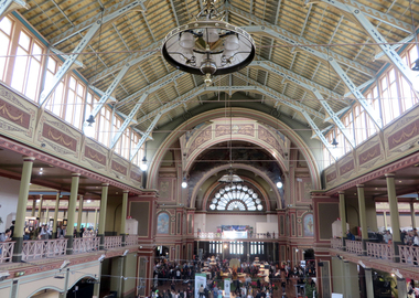
Photograph -Colour, Clare Gervasoni, Interior of the Melbourne Exhibition Building, 2019, 31/03/2019
The Melbourne International Flower and Garden Show is a flower show held annually since 1995 in early April each year, in Melbourne, Australia. It is located in the World Heritage Site of Carlton Gardens and the Royal Exhibition Building.[1] It is the largest horticultural event in the southern hemisphere, attracting over 100,000 visitors. It is rated among the top five flower and garden shows in the world. (Wikipedia)Colour photograph of the interior of the Melbourne Exhibition Buildings during the 2019 Melbourne Flower and Garden Show.melbourne international flower and garden show, carlton gardens, melbourne exhibition building -
 Ballarat Heritage Services
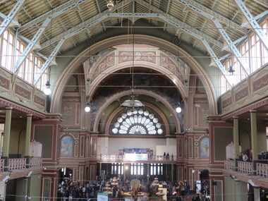
Photograph -Colour, Clare Gervasoni, Interior of the Melbourne Exhibition Building, 2019, 31/03/2019
The Melbourne International Flower and Garden Show is a flower show held annually since 1995 in early April each year, in Melbourne, Australia. It is located in the World Heritage Site of Carlton Gardens and the Royal Exhibition Building.[1] It is the largest horticultural event in the southern hemisphere, attracting over 100,000 visitors. It is rated among the top five flower and garden shows in the world. (Wikipedia)Colour photograph of the interior of the Melbourne Exhibition Buildings during the 2019 Melbourne Flower and Garden Show.melbourne international flower and garden show, carlton gardens, melbourne exhibition building -
 Ballarat Heritage Services
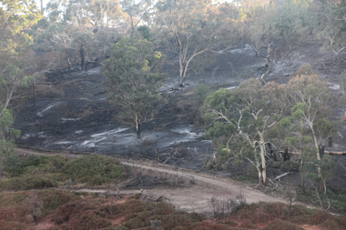
Photograph - Colour, Clare Gervasoni, Hepburn Bushfire site, 2019, 2019
Colour photographs of the site of the 2019 Hepburn Bushfire on Mannings Road / Mannings Hill, Elevaited Plans. The red line in the foreground of the photos is the remains of fire retardant from aircraft.hepburn bushfire, mannings road bushfire, mannings hill bushfire, bushfire, fire retardant, elevaitd plains -
 Ballarat Heritage Services
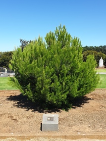
Photograph - Photograph - Colour, Clare Gervasoni, Aleppo Pine, Tower Hill Cemetery, 2019, 03/01/2019
The Tower Hill Cemetery is located near Koroit on the north side of the Princes Highway The, between Port Fairy and Warrnambool. The first burial at Tower Hill Cemetery took place in 1856. Over 150 years there has been over 8,000 burials. Around 45 percent of the burials are in unmarked graves. In 2023 this tree was no longer in existence, and a smaller tree was struggling in this site.Colour photographs of an Aleppo Pine planted in the Tower Hill Cemetery to mark the centenary of the landing at Galipolli.aleppo pine, anzac centenary, centenary, anniversary, tower hill cemetery, gallipoli -
 Ballarat Heritage Services
digital copy, Ballarat East High School Magazine 1960, 1960
School History: In February, 1955, Ballarat East High School opened in Hopetoun Street, in the vacated weatherboard buildings of the Girls’ Secondary School. In 1956, however, the School moved to its present site in Fussell Street, but because of the lack of space, Woodwork and Cookery classes were still held at Hopetoun Street. Since then there has been steady progress. The original building was extended, more classrooms and a library being built. A Domestic Science block was completed in 1957. Later, as mentioned elsewhere, sheltersheds, basketball courts, a bidycle shed and a canteen were provided for the pupils from funds raised by the Parents’ Association. Where there were previously bare areas of clayey soil we now have asphalt paths and neat gardens. Shrubs were planted, and seats, painted in the School colours, were places around the asphalted areas. (Page 5, 1959 BEHS School Magazine) 3 pdf files containing multiple pages of the BEHS 1960 School Magazinebehs, ballarat east high school, ballarat east, magazine, 1960 -
Ballarat Heritage Services
digital copy, Ballarat East High School Magazine 1961, 1961
School History: In February, 1955, Ballarat East High School opened in Hopetoun Street, in the vacated weatherboard buildings of the Girls’ Secondary School. In 1956, however, the School moved to its present site in Fussell Street, but because of the lack of space, Woodwork and Cookery classes were still held at Hopetoun Street. Since then there has been steady progress. The original building was extended, more classrooms and a library being built. A Domestic Science block was completed in 1957. Later, as mentioned elsewhere, sheltersheds, basketball courts, a bidycle shed and a canteen were provided for the pupils from funds raised by the Parents’ Association. Where there were previously bare areas of clayey soil we now have asphalt paths and neat gardens. Shrubs were planted, and seats, painted in the School colours, were places around the asphalted areas. (Page 5, 1959 BEHS School Magazine) 3 pdf files of multiple pages of BEHS School magazine=1961 behs, ballarat east high school, ballarat east, magazine, 1961 -
Ballarat Heritage Services
digital copy, Ballarat East High School Magazine 1962
School History: In February, 1955, Ballarat East High School opened in Hopetoun Street, in the vacated weatherboard buildings of the Girls’ Secondary School. In 1956, however, the School moved to its present site in Fussell Street, but because of the lack of space, Woodwork and Cookery classes were still held at Hopetoun Street. Since then there has been steady progress. The original building was extended, more classrooms and a library being built. A Domestic Science block was completed in 1957. Later, as mentioned elsewhere, sheltersheds, basketball courts, a bidycle shed and a canteen were provided for the pupils from funds raised by the Parents’ Association. Where there were previously bare areas of clayey soil we now have asphalt paths and neat gardens. Shrubs were planted, and seats, painted in the School colours, were places around the asphalted areas. (Page 5, 1959 BEHS School Magazine)4 pdf files holding multiple pages of BEHS 1962 School Magazines. These are large pdf files being each around 20MB or largerbehs, ballarat east high school, ballarat east, magazine, 1962 -
 Ballarat Heritage Services
Photograph - Colour, Clare Gervasoni, 'Kooringa, Pack Road, Marysville, 2012, 15/12/2012
A colour photographs showing the site of Kooringa, Marysville which was destroyed during the 2009 'Black Saturday' bushfire.. A newly constructed house is in the foreground.bushfire, black saturday, marysville, pack road, kooringa -
 Ballarat Heritage Services
Photograph - Colour, Toilets, Old Sarum, England, English Heritage Site, 2016, 01 November 2016
William the Conqueror inherited Old Sarum from the last Saxon king of England. It was an ideal site for a royal castle. It was here in 1070 that William paid off his army after a long and bitter campaign in northern England. It was here in 1086 that he called together all the major landholders in England so they could swear allegiance to him. It was a crucial moment. The Domesday Book was being written, a threatened Viking invasion had only just been averted and William's eldest son was in armed rebellion. Old Sarum was an important place where this Norman king of England held power. In 1794 the Ordnance Survey set out to check the accuracy of the first mapping of Southern England, which had begun ten years earlier. From a point just below Old Sarum Lieutenant William Mudge laid out a base-line 36,574 feet (11,253 metres) long. From each end of the line the positions of distant places were plotted using a huge theodolite made in 1791 by Jesse Ramsden. The accuracy of the process, which was repeated all over England, depended on Jesse Ramsden's craftsmanship and on William Mudge's surveying skill in setting out this first base-line from Old Sarum. The nearer end of Mudge's line is marked by an inscribed stone beside the modern A345 at Old Sarum. ordnance survey, william mudge, jesse ramsden, william the conqueror, old sarum, saxon, 1086, england -
 Ballarat Heritage Services
Photograph - Colour, Stonework, Old Sarum, England, English Heritage Site, 2016, 01 November 2016
William the Conqueror inherited Old Sarum from the last Saxon king of England. It was an ideal site for a royal castle. It was here in 1070 that William paid off his army after a long and bitter campaign in northern England. It was here in 1086 that he called together all the major landholders in England so they could swear allegiance to him. It was a crucial moment. The Domesday Book was being written, a threatened Viking invasion had only just been averted and William's eldest son was in armed rebellion. Old Sarum was an important place where this Norman king of England held power. In 1794 the Ordnance Survey set out to check the accuracy of the first mapping of Southern England, which had begun ten years earlier. From a point just below Old Sarum Lieutenant William Mudge laid out a base-line 36,574 feet (11,253 metres) long. From each end of the line the positions of distant places were plotted using a huge theodolite made in 1791 by Jesse Ramsden. The accuracy of the process, which was repeated all over England, depended on Jesse Ramsden's craftsmanship and on William Mudge's surveying skill in setting out this first base-line from Old Sarum. The nearer end of Mudge's line is marked by an inscribed stone beside the modern A345 at Old Sarum. ordnance survey, william mudge, jesse ramsden, william the conqueror, old sarum, saxon, 1086, england -
 Ballarat Heritage Services
Photograph - Colour, looking from Stonework towards earth mounds, Old Sarum, England, English Heritage Site, 2016, 01 November 2016
William the Conqueror inherited Old Sarum from the last Saxon king of England. It was an ideal site for a royal castle. It was here in 1070 that William paid off his army after a long and bitter campaign in northern England. It was here in 1086 that he called together all the major landholders in England so they could swear allegiance to him. It was a crucial moment. The Domesday Book was being written, a threatened Viking invasion had only just been averted and William's eldest son was in armed rebellion. Old Sarum was an important place where this Norman king of England held power. In 1794 the Ordnance Survey set out to check the accuracy of the first mapping of Southern England, which had begun ten years earlier. From a point just below Old Sarum Lieutenant William Mudge laid out a base-line 36,574 feet (11,253 metres) long. From each end of the line the positions of distant places were plotted using a huge theodolite made in 1791 by Jesse Ramsden. The accuracy of the process, which was repeated all over England, depended on Jesse Ramsden's craftsmanship and on William Mudge's surveying skill in setting out this first base-line from Old Sarum. The nearer end of Mudge's line is marked by an inscribed stone beside the modern A345 at Old Sarum. ordnance survey, william mudge, jesse ramsden, william the conqueror, old sarum, saxon, 1086, england -
 Ballarat Heritage Services
Photograph - Colour, Looking from Stonework towards people walking on earth mounds, Old Sarum, England, English Heritage Site, 2016, 01 November 2016
William the Conqueror inherited Old Sarum from the last Saxon king of England. It was an ideal site for a royal castle. It was here in 1070 that William paid off his army after a long and bitter campaign in northern England. It was here in 1086 that he called together all the major landholders in England so they could swear allegiance to him. It was a crucial moment. The Domesday Book was being written, a threatened Viking invasion had only just been averted and William's eldest son was in armed rebellion. Old Sarum was an important place where this Norman king of England held power. In 1794 the Ordnance Survey set out to check the accuracy of the first mapping of Southern England, which had begun ten years earlier. From a point just below Old Sarum Lieutenant William Mudge laid out a base-line 36,574 feet (11,253 metres) long. From each end of the line the positions of distant places were plotted using a huge theodolite made in 1791 by Jesse Ramsden. The accuracy of the process, which was repeated all over England, depended on Jesse Ramsden's craftsmanship and on William Mudge's surveying skill in setting out this first base-line from Old Sarum. The nearer end of Mudge's line is marked by an inscribed stone beside the modern A345 at Old Sarum. ordnance survey, william mudge, jesse ramsden, william the conqueror, old sarum, saxon, 1086, england -
 Ballarat Heritage Services
Photograph - Colour, Stairs, Old Sarum, England, English Heritage Site, 2016, 01 November 2016
William the Conqueror inherited Old Sarum from the last Saxon king of England. It was an ideal site for a royal castle. It was here in 1070 that William paid off his army after a long and bitter campaign in northern England. It was here in 1086 that he called together all the major landholders in England so they could swear allegiance to him. It was a crucial moment. The Domesday Book was being written, a threatened Viking invasion had only just been averted and William's eldest son was in armed rebellion. Old Sarum was an important place where this Norman king of England held power. In 1794 the Ordnance Survey set out to check the accuracy of the first mapping of Southern England, which had begun ten years earlier. From a point just below Old Sarum Lieutenant William Mudge laid out a base-line 36,574 feet (11,253 metres) long. From each end of the line the positions of distant places were plotted using a huge theodolite made in 1791 by Jesse Ramsden. The accuracy of the process, which was repeated all over England, depended on Jesse Ramsden's craftsmanship and on William Mudge's surveying skill in setting out this first base-line from Old Sarum. The nearer end of Mudge's line is marked by an inscribed stone beside the modern A345 at Old Sarum. ordnance survey, william mudge, jesse ramsden, william the conqueror, old sarum, saxon, 1086, england -
 Ballarat Heritage Services
Photograph - Colour, Public toilets hidden in earth mound, Old Sarum, England, English Heritage Site, 2016, 01 November 2016
William the Conqueror inherited Old Sarum from the last Saxon king of England. It was an ideal site for a royal castle. It was here in 1070 that William paid off his army after a long and bitter campaign in northern England. It was here in 1086 that he called together all the major landholders in England so they could swear allegiance to him. It was a crucial moment. The Domesday Book was being written, a threatened Viking invasion had only just been averted and William's eldest son was in armed rebellion. Old Sarum was an important place where this Norman king of England held power. In 1794 the Ordnance Survey set out to check the accuracy of the first mapping of Southern England, which had begun ten years earlier. From a point just below Old Sarum Lieutenant William Mudge laid out a base-line 36,574 feet (11,253 metres) long. From each end of the line the positions of distant places were plotted using a huge theodolite made in 1791 by Jesse Ramsden. The accuracy of the process, which was repeated all over England, depended on Jesse Ramsden's craftsmanship and on William Mudge's surveying skill in setting out this first base-line from Old Sarum. The nearer end of Mudge's line is marked by an inscribed stone beside the modern A345 at Old Sarum. ordnance survey, william mudge, jesse ramsden, william the conqueror, old sarum, saxon, 1086, england -
 Ballarat Heritage Services
Photograph - Colour, Entrance to Public toilets hidden in earth mound, Old Sarum, England, English Heritage Site, 2016, 01 November 2016
William the Conqueror inherited Old Sarum from the last Saxon king of England. It was an ideal site for a royal castle. It was here in 1070 that William paid off his army after a long and bitter campaign in northern England. It was here in 1086 that he called together all the major landholders in England so they could swear allegiance to him. It was a crucial moment. The Domesday Book was being written, a threatened Viking invasion had only just been averted and William's eldest son was in armed rebellion. Old Sarum was an important place where this Norman king of England held power. In 1794 the Ordnance Survey set out to check the accuracy of the first mapping of Southern England, which had begun ten years earlier. From a point just below Old Sarum Lieutenant William Mudge laid out a base-line 36,574 feet (11,253 metres) long. From each end of the line the positions of distant places were plotted using a huge theodolite made in 1791 by Jesse Ramsden. The accuracy of the process, which was repeated all over England, depended on Jesse Ramsden's craftsmanship and on William Mudge's surveying skill in setting out this first base-line from Old Sarum. The nearer end of Mudge's line is marked by an inscribed stone beside the modern A345 at Old Sarum. ordnance survey, william mudge, jesse ramsden, william the conqueror, old sarum, saxon, 1086, england -
 Ballarat Heritage Services
Photograph - Colour, Masons' Marks, Old Sarum, England, English Heritage Site, 2016, 01 November 2016
William the Conqueror inherited Old Sarum from the last Saxon king of England. It was an ideal site for a royal castle. It was here in 1070 that William paid off his army after a long and bitter campaign in northern England. It was here in 1086 that he called together all the major landholders in England so they could swear allegiance to him. It was a crucial moment. The Domesday Book was being written, a threatened Viking invasion had only just been averted and William's eldest son was in armed rebellion. Old Sarum was an important place where this Norman king of England held power. In 1794 the Ordnance Survey set out to check the accuracy of the first mapping of Southern England, which had begun ten years earlier. From a point just below Old Sarum Lieutenant William Mudge laid out a base-line 36,574 feet (11,253 metres) long. From each end of the line the positions of distant places were plotted using a huge theodolite made in 1791 by Jesse Ramsden. The accuracy of the process, which was repeated all over England, depended on Jesse Ramsden's craftsmanship and on William Mudge's surveying skill in setting out this first base-line from Old Sarum. The nearer end of Mudge's line is marked by an inscribed stone beside the modern A345 at Old Sarum. ordnance survey, william mudge, jesse ramsden, william the conqueror, old sarum, saxon, 1086, england -
 Ballarat Heritage Services
Photograph - Colour, Masons' Marks, Old Sarum, England, English Heritage Site, 01 November 2016
William the Conqueror inherited Old Sarum from the last Saxon king of England. It was an ideal site for a royal castle. It was here in 1070 that William paid off his army after a long and bitter campaign in northern England. It was here in 1086 that he called together all the major landholders in England so they could swear allegiance to him. It was a crucial moment. The Domesday Book was being written, a threatened Viking invasion had only just been averted and William's eldest son was in armed rebellion. Old Sarum was an important place where this Norman king of England held power. In 1794 the Ordnance Survey set out to check the accuracy of the first mapping of Southern England, which had begun ten years earlier. From a point just below Old Sarum Lieutenant William Mudge laid out a base-line 36,574 feet (11,253 metres) long. From each end of the line the positions of distant places were plotted using a huge theodolite made in 1791 by Jesse Ramsden. The accuracy of the process, which was repeated all over England, depended on Jesse Ramsden's craftsmanship and on William Mudge's surveying skill in setting out this first base-line from Old Sarum. The nearer end of Mudge's line is marked by an inscribed stone beside the modern A345 at Old Sarum. ordnance survey, william mudge, jesse ramsden, william the conqueror, old sarum, saxon, 1086, england -
 Ballarat Heritage Services
Photograph - Colour, Masons' Marks, Old Sarum, England, English Heritage Site, 2016, 01 November 2016
William the Conqueror inherited Old Sarum from the last Saxon king of England. It was an ideal site for a royal castle. It was here in 1070 that William paid off his army after a long and bitter campaign in northern England. It was here in 1086 that he called together all the major landholders in England so they could swear allegiance to him. It was a crucial moment. The Domesday Book was being written, a threatened Viking invasion had only just been averted and William's eldest son was in armed rebellion. Old Sarum was an important place where this Norman king of England held power. In 1794 the Ordnance Survey set out to check the accuracy of the first mapping of Southern England, which had begun ten years earlier. From a point just below Old Sarum Lieutenant William Mudge laid out a base-line 36,574 feet (11,253 metres) long. From each end of the line the positions of distant places were plotted using a huge theodolite made in 1791 by Jesse Ramsden. The accuracy of the process, which was repeated all over England, depended on Jesse Ramsden's craftsmanship and on William Mudge's surveying skill in setting out this first base-line from Old Sarum. The nearer end of Mudge's line is marked by an inscribed stone beside the modern A345 at Old Sarum. ordnance survey, william mudge, jesse ramsden, william the conqueror, old sarum, saxon, 1086, england -
 Ballarat Heritage Services
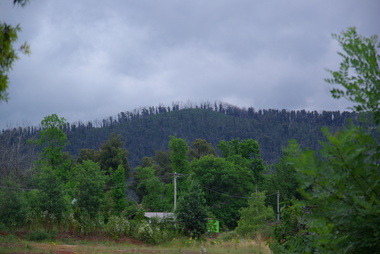
Photograph, Clare Gervasoni, Camberville Mill Site, 2014, 04/11/2014
Colour photograph at Camberville, Victoria.camberville, forestry, forest -
 Ballarat Heritage Services
Photograph, Clare Gervasoni, Camberville Mill Site, 2014, 04/11/2014
Colour photograph at Camberville, Victoria.camberville, forest -
 Ballarat Heritage Services
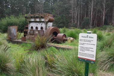
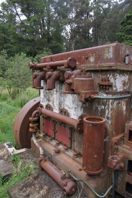
Photograph, Clare Gervasoni, Camberville Mill Site, 2014, 04/11/2014
Colour photograph of abandoned machinery at Camberville. camberville, forestry, machinery -
 Ballarat Heritage Services
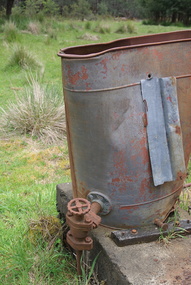
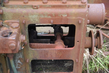
Photograph, Camberville Mill Site, 2014, 04/11/2014
camberville, camberville mill -
 Ballarat Heritage Services
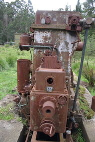
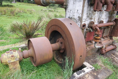
Photograph, Camberville Mill Site, 2014, 04/11/2014
camberville, camberville mill -
 Ballarat Heritage Services
Photograph, Camberville Mill Site, 2014, 04/11/2014
-
 Ballarat Heritage Services
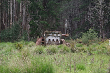
Photograph, Camberville Mill Site, 2014, 04/11/2014
camberville, camberville mill -
 Ballarat Heritage Services
Photograph, Mullock Heap In Victoria Park, Ballarat, 2014, 04/11/2014
The large mullock heap, marks the site of a former quartz mine, and is one of the few visible signs of the former presence of extensive gold mining activities in this area of Ballarat. Originally known as Park Mine, and now known as Mount Holled Smith, the mine associated with this mullock heap puddled 750 tons of washdirt each day. The mine closed down in 1874, at which time 94,699 ounces of gold had been removed from the ground. Colour photograph of a mullock heap in Ballarat's Victoria Park.mullock heap, ballarat gardens, victoria park, park mine -
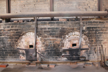 Ballarat Heritage Services
digital photographs, Lisa Gervasoni, Glenthompson Brickworks, c2010-2017
The Thompson brothers, George and Joseph, formerly of Ballarat and the new owners of Yallum Park, established the Glenthompson Brickworks in 1900. The entire process of creating a solid, pressed Glenthompson Brick happens on site, where red and cream clay is excavated. Brick presses dating back to 1940 are still in operation today, the kilns are stacked by hand to ensure specific needs are met and colour varieties are achieved. Refined oil is used to fire down draught kilns, which allows temperatures to be adjusted to ensure unique colour ranges are achieved.Colour photographs of kilns at Glenthompson Brickworks. building, heritage, glenthompson, industry, industrial heritage, brickworks, oven, glenthompson brickworks, george thompson, joseph thompson