Showing 3420 items
matching bridge road
-
 Eltham District Historical Society Inc
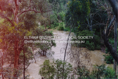
Photograph, Flooding of Diamond Creek at Lower Eltham Main Road bridge, Nov 2004, 2004
... Flooding of Diamond Creek at Lower Eltham Main Road bridge... at the Lower Eltham Main Road bridge in Nov 2004... melbourne eltham main road bridges diamond creek floods Two colour ...Two colour photographs of the flooded Diamond Creek at the Lower Eltham Main Road bridge in Nov 2004eltham, main road, bridges, diamond creek, floods -
 Eltham District Historical Society Inc
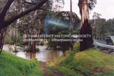
Photograph, Flooding of Diamond Creek at Lower Eltham Main Road bridge, Nov 2004, 2004
... Flooding of Diamond Creek at Lower Eltham Main Road bridge... at the Lower Eltham Main Road bridge in Nov 2004... melbourne eltham main road bridges diamond creek floods Two colour ...Two colour photographs of the flooded Diamond Creek at the Lower Eltham Main Road bridge in Nov 2004eltham, main road, bridges, diamond creek, floods -
 Eltham District Historical Society Inc
Album - Photograph, J.A. McDonald, Cecil Street Bridge, Eltham-Yarra Glen Road, Eltham, Oct. 1962
... Cecil Street Bridge, Eltham-Yarra Glen Road, Eltham...Eltham-Yarra Glen Road Cecil Street Bridge Looking upstream... melbourne Eltham-Yarra Glen Road Cecil Street Bridge Looking ...Eltham-Yarra Glen Road Cecil Street Bridge Looking upstream Oct. 1962Record of various Shire of Eltham infrastructure works undertaken during the period of 1952-1962 involving bridge and road reconstruction projects, sometimes with Eltham Shire Council Project Reference numbers quoted. It was during this period that a number of significant improvements were made to roads and new bridges constructed within the shire that remain in place as of present day (2022). In many situations, the photos provide a tangible visible record of infrastructure that existed throughout the early days of the Shire. The album was put together by or under the direction of the Shire Engineer, J.A. McDonald.H941 stamped on reverse (film processing #)infrastructure, shire of eltham, bridge construction, road construction, 1962-10, bible street reserve, cecil street bridge, eltham, eltham-yarra glen road, main road -
 Eltham District Historical Society Inc
Album - Photograph, J.A. McDonald, Cecil Street Bridge, Eltham-Yarra Glen Road, Eltham, Oct. 1962
... Cecil Street Bridge, Eltham-Yarra Glen Road, Eltham...Eltham-Yarra Glen Road Cecil Street Bridge Looking upstream... melbourne Eltham-Yarra Glen Road Cecil Street Bridge Looking ...Eltham-Yarra Glen Road Cecil Street Bridge Looking upstream Oct. 1962Record of various Shire of Eltham infrastructure works undertaken during the period of 1952-1962 involving bridge and road reconstruction projects, sometimes with Eltham Shire Council Project Reference numbers quoted. It was during this period that a number of significant improvements were made to roads and new bridges constructed within the shire that remain in place as of present day (2022). In many situations, the photos provide a tangible visible record of infrastructure that existed throughout the early days of the Shire. The album was put together by or under the direction of the Shire Engineer, J.A. McDonald.H941 stamped on reverse (film processing #)infrastructure, shire of eltham, bridge construction, road construction, 1962-10, cecil street bridge, eltham, eltham-yarra glen road, main road -
 Eltham District Historical Society Inc
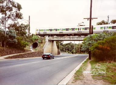
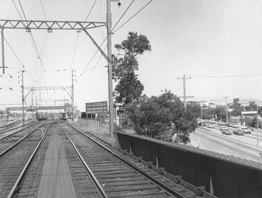
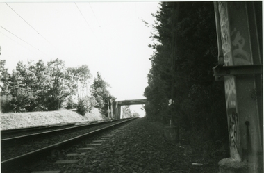
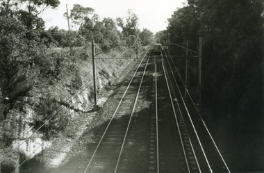
Photograph, Train passing over the Sherbourne Road railway bridge
... Train passing over the Sherbourne Road railway bridge... melbourne railway bridge sherbourne road train streets Colour ...Colour photographrailway bridge, sherbourne road, train, streets -
 Linton and District Historical Society Inc
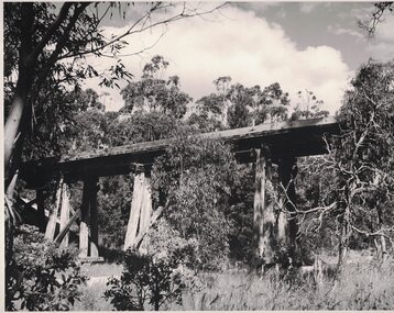
Photograph, Railway Bridge over Mortchup Road near Linton
... Railway Bridge over Mortchup Road near Linton...Mortchup Road railway bridge...Black and white image of a wooden trestle bridge elevated...Mortchup Road railway bridge Black and white image ...Black and white image of a wooden trestle bridge elevated over a road.mortchup road railway bridge -
 Kew Historical Society Inc
Photograph - Yarra Flats near Burke Road Bridge, 1937
... Yarra Flats near Burke Road Bridge... to be the Yarra Flats near Burke Road Bridge. On the horizon, building can... Road Bridge ...Land along the Yarra River in Kew is now either designated open space, parkland or public golf links. By the 1930s much of this area remained open farmland, bought at auction for dairy farming in the 1840s.Original, black and white positive print of what is said to be the Yarra Flats near Burke Road Bridge. On the horizon, building can be seen, whereas in the middle ground, farm fencing and a windmill are the main features as well as remnant Eucalypts. Inscribed verso: "Yarra Flats near Burke Rd Bridge 1937" studley park -- kew (vic.) -
 Ringwood and District Historical Society
Photograph, Eastfield Road bridge just opened - looking east. Ringwood 1978
... Eastfield Road bridge just opened - looking east. Ringwood...Written on back of photograph, "Late 1978. Eastfield Road..., "Late 1978. Eastfield Road bridge just opened - looking east ...Written on back of photograph, "Late 1978. Eastfield Road bridge just opened - looking east." -
 Ringwood and District Historical Society
Photograph, The old Warrandyte Road bridge viewed across bypass. Ringwood, 1986
... The old Warrandyte Road bridge viewed across bypass... viewed across bypass." (Warrandyte Road bridge)..., "29.11.86. The old bridge viewed across bypass." (Warrandyte Road ...Written on back of photograph, "29.11.86. The old bridge viewed across bypass." (Warrandyte Road bridge) -
 Ringwood and District Historical Society
Photograph, Warrandyte Road Bridge over Mullum Mullum Creek, Ringwood 1986
... Warrandyte Road Bridge over Mullum Mullum Creek, Ringwood.... Warrandyte Road Bridge over Mullum Mullum Creek"...., "3.8.86. Ringwood. Warrandyte Road Bridge over Mullum Mullum Creek ...Written on back of photograph, "3.8.86. Ringwood. Warrandyte Road Bridge over Mullum Mullum Creek". -
 Ringwood and District Historical Society
Photograph, Ringwood Railway Station overlooking Maroondah Hwy viewed from bridge over Warrandyte Road in foreground, 1974
... from bridge over Warrandyte Road in foreground, 1974...., 1974 from bridge over Warrandyte Road."..., 1974 from bridge over Warrandyte Road." Black and White ...Black and White photographWritten on back of photograph, "Ringwood Railway Station, 1974 from bridge over Warrandyte Road." -
 Ringwood and District Historical Society
Photograph, Ringwood Railway Station, 1974, viewed from bridge over Warrandyte Road in foreground, looking west
... Ringwood Railway Station, 1974, viewed from bridge over..., 1974. From bridge over Warrandyte Road"...., 1974. From bridge over Warrandyte Road". Black and White ...Black and White photographWritten on back of photograph, "Ringwood Railway Station, 1974. From bridge over Warrandyte Road". -
 Ringwood and District Historical Society
Photograph, Maroondah Highway West, Ringwood, 1965. Wantirna Road bridge
... Maroondah Highway West, Ringwood, 1965. Wantirna Road...Typed below photograph, "Wantirna Road railway bridge... Road railway bridge. Widening underpass - 1965". Maroondah ...Typed below photograph, "Wantirna Road railway bridge. Widening underpass - 1965". -
 Ringwood and District Historical Society
Photograph-B&W, Joan Walker, East Ringwood 2000-Eastfield Road Bridge looking West To East Ringwood, 2000
... East Ringwood 2000-Eastfield Road Bridge looking West To...East Ringwood 2000-Eastfield Road Bridge looking West... East Ringwood 2000-Eastfield Road Bridge looking West To East ...East Ringwood 2000-Eastfield Road Bridge looking West To East Ringwood- B&W Photo from Album 6501 -
 Ringwood and District Historical Society
Photograph, Earth fill over culverts in place of old Warrandyte Road bridge, Ringwood 1986
... Earth fill over culverts in place of old Warrandyte Road... culverts in place of old Warrandyte Road bridge."... bridge." Earth fill over culverts in place of old Warrandyte Road ...Written on back of photograph, "29.22.86. Earth fill over culverts in place of old Warrandyte Road bridge." -
 Ringwood and District Historical Society
Photograph, Mullum Mullum Creek. West side of Warrandyte Road Bridge. Ringwood 1986
... Mullum Mullum Creek. West side of Warrandyte Road Bridge... Mullum Creek. West side of Warrandyte Road Bridge."... Road Bridge." Mullum Mullum Creek. West side of Warrandyte Road ...Written on back of photograph, "3.8.86. Ringwood. Mullum Mullum Creek. West side of Warrandyte Road Bridge." -
 Ringwood and District Historical Society
Photograph, Maroondah Highway West, Ringwood, 1965. Wantirna Road bridge
... Maroondah Highway West, Ringwood, 1965. Wantirna Road...Written on back of photograph, "Wantirna Road railway..., "Wantirna Road railway bridge. Preparing to widen underpass - 1965 ...Written on back of photograph, "Wantirna Road railway bridge. Preparing to widen underpass - 1965". -
 Whitehorse Historical Society Inc.
Photograph, Quarry Road Bridge, Mitcham, 2007
... Quarry Road Bridge, Mitcham...Coloured Photo of Quarry Road Bridge, Mitcham near... Mitcham melbourne quarry road mitcham bridges Coloured Photo ...Coloured Photo of Quarry Road Bridge, Mitcham near boundary of Whitehorse Road and Manningham Municipalities. (See record number NP3411 above)quarry road, mitcham, bridges -
 Stawell Historical Society Inc
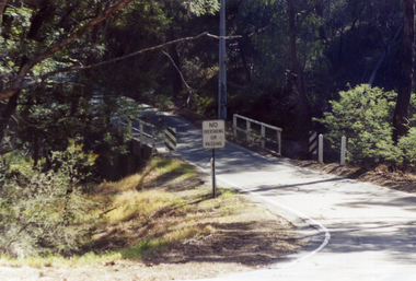
Photograph, Concongella Creek Bridge on the Navarre Road
... Concongella Creek Bridge on the Navarre Road...Concongella Creek Bridge Navarre Road... grampians Concongella Creek Bridge Navarre Road Stawell Concongella ...Concongella Creek Bridge Navarre Roadstawell -
 Ringwood and District Historical Society
Photograph, Warrandyte Road bridge from footpath near St. Pauls Anglican Church, Ringwood. Circa 1986-7
... Warrandyte Road bridge from footpath near St. Pauls...Written on back of photograph, "Date ? Warrandyte Road..., "Date ? Warrandyte Road bridge from footpath near St. Pauls ...Written on back of photograph, "Date ? Warrandyte Road bridge from footpath near St. Pauls Anglican Church." -
 Whitehorse Historical Society Inc.
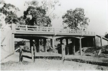
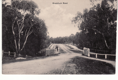
Postcard - Black and white postcard, Blackburn Road Bridge in Blackburn. Circa 1908, C.1914
... Blackburn Road Bridge in Blackburn. Circa 1908.... Creek bridge looking south featuring Bridge over unmade road... Creek bridge looking south featuring Bridge over unmade road ...Black and white postcard of Blackburn Road at Gardiner's Creek bridge looking south featuring Bridge over unmade road. Entitled 'Blackburn Road'hooke, janet emily, albert arthur, blackburn road, blackburn -
 Eltham District Historical Society Inc
Photograph, Mountain View Road railway bridge, Montmorency
... Mountain View Road railway bridge, Montmorency...Black and white photograph of railway bridge, Mountain View... melbourne bridges railways mountain view road montmorency Black ...Black and white photograph of railway bridge, Mountain View Road, Montmorencybridges, railways, mountain view road, montmorency -
 Ringwood and District Historical Society
Photograph-B&W, Joan Walker, East Ringwood 2000-Taken from the Eastfield Road Bridge looking towards the East Ringwood Station, 2000
... East Ringwood 2000-Taken from the Eastfield Road Bridge...East Ringwood 2000-Taken from the Eastfield Road Bridge... the Eastfield Road Bridge looking towards the East Ringwood Station- B&W ...East Ringwood 2000-Taken from the Eastfield Road Bridge looking towards the East Ringwood Station- B&W Photo from Album 6501 -
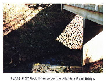 Eltham District Historical Society Inc
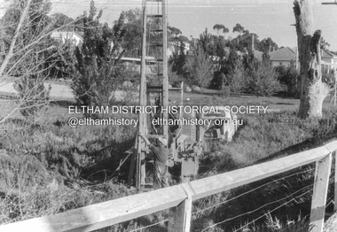
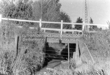
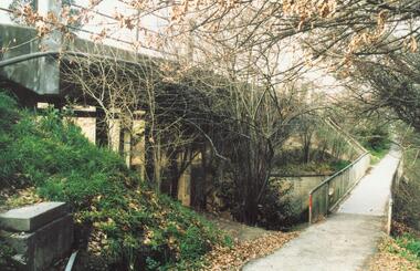
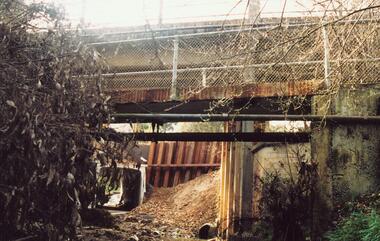
Work on paper (Sub-Item) - Photograph, Rock lining under the Allendale Road Bridge, 1976
... Rock lining under the Allendale Road Bridge... under the Allendale Road Bridge, Eltham North... under the Allendale Road Bridge, Eltham North rock lining bridge ...Colour photograph of rock lining along the Diamond creek under the Allendale Road Bridge, Eltham Northrock lining, bridge, eltham north, diamond creek -
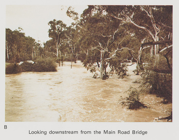 Eltham District Historical Society Inc
Work on paper (Sub-Item) - Photograph, Flooding, looking downstream from Main Road Bridge, Eltham 8 April 1977
... Flooding, looking downstream from Main Road Bridge, Eltham... from Main Road Bridge, Eltham , 8 April 1977. ... from Main Road Bridge, Eltham , 8 April 1977. flood diamond ...Colour photograph. Looking downstream on the Diamond Creek from Main Road Bridge, Eltham , 8 April 1977. flood, diamond creek, flooding, main road, eltham -
 Ringwood and District Historical Society
Photograph, Warrandyte Road bridge over Mullum Creek, Ringwood. 1921 or 1931
... Warrandyte Road bridge over Mullum Creek, Ringwood. 1921 or...Written on photographs, "Warrandyte Road bridge over Mullum..., "Warrandyte Road bridge over Mullum Creek" One photograph is dated ...Written on photographs, "Warrandyte Road bridge over Mullum Creek" One photograph is dated 1921 and the other 1931. (3 copies) -
 Glenelg Shire Council Cultural Collection
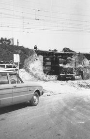
Photograph - Photograph - Bridgewater Construction, n.d
... Bridgewater Road Bridge construction...Black and white photo of Otway street/Bridgewater road...' 4x2 1/4 - Pencil 'Bridgewater road bridge 29/3/57 looking... Bridgewater Road Bridge construction Front: Back- Margin ruled ...Port of Portland Authority ArchivesFront: Back- Margin ruled in pencil, diagonal in pencil. 'C' 4x2 1/4 - Pencil 'Bridgewater road bridge 29/3/57 looking s.s.w'- written in blue biro. 'Otway Street Bridge - Pencilport of portland archives, otway street bridge, bridgewater road bridge construction -
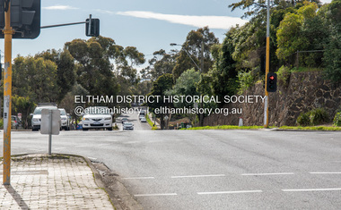 Eltham District Historical Society Inc
Photograph, Peter Pidgeon, Main Road at Bridge Street, Eltham, 2 Aug. 2022
... Main Road at Bridge Street, Eltham... photographer J.H. Clark Eltham J.H. Clark Photo (2022) Main Road Bridge ...Comparison photo: SEPP_0708 Part of a presentation by Peter Pidgeon to the Society, 13 August 2022 showcasing a series of photographs taken by John Henry Clark over the period 1895 to 1930. John Henry Clark was the youngest of three boys born to William Henry Clark (1823-1877) and Maria White (1843-1914). He and his brothers, William Charles Clark (1872-1945), Clement Kent Clark (1874-1912) operated a photography business (Clark Bros.) from 25 Thomas Street, Windsor near Prahran during the period c.1894 to 1914. Following death of Clement in September 1912 and their mother in 1914, the Clark Bros business appears to have dissolved, the premises demolished, and a new house was under construction in 1915. John set up business independently in 1914 operating out of 29 Moor Street, Fitzroy where he is registered in the 1914 and 1915 Electoral Rolls. By 1916 John had relocated to Eltham where he continued his practice as a photographer and took many of the early images around the district of Little Eltham. Around 1930 John changed professions and opened a small cobbler's shop in 1931 near the pond opposite Dalton Street adjacent to the Jarrold family cottage. He never married and continued his profession as a bootmaker from this little shop, maintaining a close relationship with Mrs Jarrold for the rest of their lives. His bootmaker shop remains today beside the Whitecloud cottage and is one of only three remaining shops in the area from the early 20th century.Comparative photo taken 2022 with one taken from same location over 100 years earlier by noted local photographer J.H. ClarkBorn Digitaleltham, j.h. clark photo (2022), main road, bridge street -
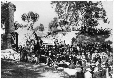 Eltham District Historical Society Inc
Negative - Photograph, Unveiling of War Memorial Obelisk, corner of Main Road and Bridge Street, Eltham
... Unveiling of War Memorial Obelisk, corner of Main Road and..., corner of Main Road and Bridge Street, Eltham Negative Photograph ...The unveiling of the Eltham Obelisk War Memorial was performed by the Rev. Padre Charles Tregear, assisted by Church of England vicar, Mr Safsford on August 3, 1919. Reproduced page 99 of "Pioneers & Painters." "Beneath a lonely pine tree on the hill crest out from Eltham, where the Greensborough Road junctions with the main Melbourne Road, Eltham has erected an everlasting tribute to the memory of the fallen heroes of the district. It is an obelisk of Harcourt granite in the rough, bearing an appropriate inscription and 27 names—an unpretentious monument by the wayside, which will stand for all time silently expressing the appreciation of the living for the sacrifice of the dead. The obelisk stands 14 feet high. ... Representatives of every house in the town, and many people from the surrounding district, gathered around the obelisk for the opening ceremony. The spring-like sunshine of the afternoon attracted everybody out of doors. There must have been 700 people present when the Lieutenant-Governor, Sir William Irvine, removed the draping of flags and revealed the names on the obelisk, the base of which was surrounded by wreaths and branches of wattle bloom, placed there by parents whose sorrow at the loss of sons was blunted, for the day at least, by feelings of pride. .." Age, Monday 4 August 1919, page 8 This was the memorial's orginal location. It has been relocated numerous times.This photo forms part of a collection of photographs gathered by the Shire of Eltham for their centenary project book,"Pioneers and Painters: 100 years of the Shire of Eltham" by Alan Marshall (1971). The collection of over 500 images is held in partnership between Eltham District Historical Society and Yarra Plenty Regional Library (Eltham Library) and is now formally known as the 'The Shire of Eltham Pioneers Photograph Collection.' It is significant in being the first community sourced collection representing the places and people of the Shire's first one hundred years.Digital image 4 x 5 inch B&W Negsepp, shire of eltham pioneers photograph collection, eltham, main road, bridge street, eltham war memorial, obelisk, obelisk corner -
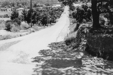 Eltham District Historical Society Inc
Photograph, Looking west along Bridge Street, from Main Road, Eltham, February 1968, Feb 1968
... Looking west along Bridge Street, from Main Road, Eltham.... duplication eltham main road bridge street susan street Black ...Shows the Diamond Creek bridge and part of Susan Street In February 1968 an unknown person took a series of photos from the Eltham Hotel at Pitt Street heading north along Main Road through the shopping centre to just north of Elsa Court covering the length of the section of Main Road which was duplicated shortly thereafter. Shows the condition and environment of the streesscape of Main Road, Eltham immediately prior to the duplication between Pitt Street and Elsa Court through the shopping centre. Also shows a number of shops and businesses that operated at that time.Black and white photographduplication, eltham, main road, bridge street, susan street