Showing 209 items
matching bullock island
-
 Lakes Entrance Historical Society
Photograph - Lakes Entrance, Gippsland Ports, 2006 c
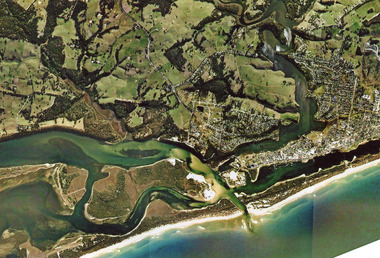
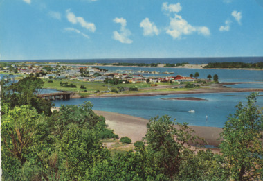
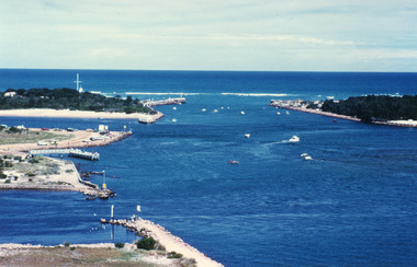
... to Gippsland Lakes including Bullock Island Reeves Channel Rigby Island... Bullock Island Reeves Channel Rigby Island houses on Kalimna Hill ...Second copyColour aerial photograph of entrance from Bass Strait to Gippsland Lakes including Bullock Island Reeves Channel Rigby Island houses on Kalimna Hill and Princes Highway winding down Jemmys Point hill into township of Lakes Entrance Victoriaaerial photograph, ocean, waterways -
 Lakes Entrance Historical Society
Postcard, Bulmer H D, 1950c
... Point, showing Bullock Island between North Arm and Cunninghame... Highway Jemmys Point, showing Bullock Island between North Arm ...Also one other postcard same donated by M & V Carpenter in spares box.Black and white postcard of the Princes Highway Jemmys Point, showing Bullock Island between North Arm and Cunninghame Arm, distant view of the entrance from Bass Strait to the Gippsland Lakes. Post and rail fence along roadside. Lakes Entrance VictoriaPrinces Highway and a view of the Entrance vegetation, roads and streets -
 Lakes Entrance Historical Society
Photograph - Topography, 2007c
... between Rigby Island and Kalimna, also Bullock Island. Lakes... Bullock Island. Lakes Entrance Victoria Photograph Topography ...Colour aerial photograph of the land forms around the entrance to the Gippsland Lakes, from Kalimna West to Lakes Entrance, North Arm to the ocean. Shows massive sand buildup between Rigby Island and Kalimna, also Bullock Island. Lakes Entrance Victoriawaterways, navigation, topography -
 Lakes Entrance Historical Society
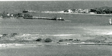
Photograph - The Entrance, Calvert Barbara, 1960c
... . It also shows the rock groynes at Bullock Island with dredged sand... at Bullock Island with dredged sand starting to fill the basins ...Black and white photograph of the man-made entrance from Bass Strait to the Gippsland Lakes taken from Jemmys Point. It also shows the rock groynes at Bullock Island with dredged sand starting to fill the basins to enlarge the island. Lakes Entrance Victoriawaterways, public works -
 Lakes Entrance Historical Society
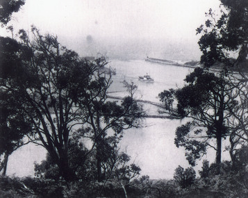
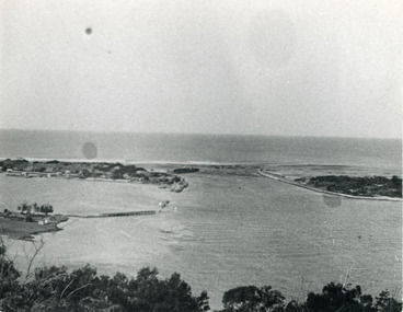
Photograph - The Entrance, 1920c
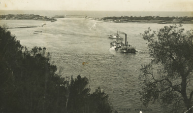
... at Jemmys Point. It also shows the rock groynes at Bullock Island... groynes at Bullock Island. A steamer is entering the lakes from ...Black and white photograph of the man-made entrance from Bass Strait to the Gippsland Lakes, taken from the road at Jemmys Point. It also shows the rock groynes at Bullock Island. A steamer is entering the lakes from Cunninghame Arm. Lakes Entrance Victoriawaterways, ships and shipping -
 Lakes Entrance Historical Society
Postcard - Dredge Pioneer, Segerberg and Bulmer, 1910 c
... of Bullock Island calm entrance in distance steamer JCD heading... Jemmys Point facing entrance rock groynes on west of Bullock ...Message on back Arrived safe 25th have a good time hoping you are well from FCG Addressed to Mrs FC Gason, Jessops Hill, Lower NicholsonBlack and white postcard showing dredge Pioneer working below Jemmys Point facing entrance rock groynes on west of Bullock Island calm entrance in distance steamer JCD heading across Reeves Channel after leaving Lakes Entrance VictoriaLakes Entrance waterways, dredges, correspondence -
 Lakes Entrance Historical Society
Photograph - The Entrance, 1945c
... . It also shows the rock groynes at the western end of Bullock... at the western end of Bullock Island, and at the entrances to Cunninghame ...Other copiesHand tinted colour photograph of the man-made entrance from Bass Strait to the Gippsland lakes, taken from Jemmys Point. It also shows the rock groynes at the western end of Bullock Island, and at the entrances to Cunninghame Arm and the North Arm. Lakes Entrance VictoriaThe Entrance, Lakes Entranceislands, waterways, boats and boating -
 Lakes Entrance Historical Society
Photograph - The Entrance, Tambo Shire, 1990
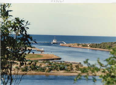
... spit on right, eastern spit hidden behind bush, Bullock Island..., Bullock Island on left centre, mouth of North Arm in foreground ...Colour photograph showing the entrance to the lakes from Bass Strait, dredge April Hamer working on the bar. Western spit on right, eastern spit hidden behind bush, Bullock Island on left centre, mouth of North Arm in foreground, Lakes Entrance, Victoria.waterways, islands, township -
 Lakes Entrance Historical Society
Photograph, 2001
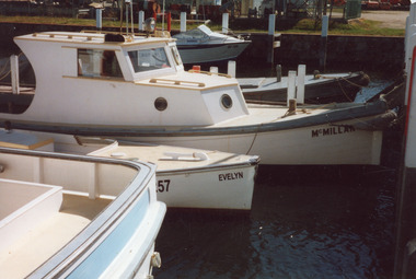
... on Bullock Island. Small cabin cruiser called McMillan, open cockpit... Colour photograph of boats tied up at the Ports Jetty on Bullock ...Date made November 2001Colour photograph of boats tied up at the Ports Jetty on Bullock Island. Small cabin cruiser called McMillan, open cockpit workboat called Evelyn, in foreground transom of larger cabin cruiser and in the background is a small aluminium run about. Lakes Entrance Victoriaships and shipping, dredging, jetties -
 Lakes Entrance Historical Society
Postcard - The Entrance, 1940c
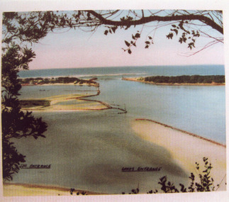
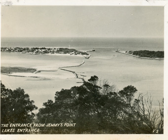
... of Bullock Island, Reeves and Entrance Channels, the Entrance... of the Western end of Bullock Island, Reeves and Entrance Channels ...Originally in a pack of miniature postcards produced for sale to tourists.Black and white small format postcard of the Western end of Bullock Island, Reeves and Entrance Channels, the Entrance and Carpenter Town at the New Works. Taken from Jemmys Point, it shows rock groynes built to channel water flow to the Entrance. Lakes Entrance VictoriaThe Entrance Jemmys Point Lakes Entrance V2 topography, waterways -
 Lakes Entrance Historical Society
Postcard - North Arm, Valentine Series, 1930c
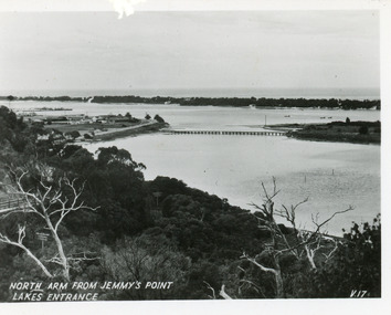
... Hotel at western end of town, bridge to Bullock Island, scrub... to Bullock Island, scrub covered hummocks and Bass Strait in distance ...This is the before paired photograph used in the 150 year Lakes Entrance 1858-2008 display.|The after paired photograph number is 01590.1 Also one 12 x 16 framed photograph used in room display.Black and white small format postcard of North Arm and Cunninghame Arm of Gippsland Lakes, taken from Jemmys Point, Club Hotel at western end of town, bridge to Bullock Island, scrub covered hummocks and Bass Strait in distance. Lakes Entrance VictoriaNorth Arm from Jemmys Point Lakes Entrancebridges, islands, waterways, topography -
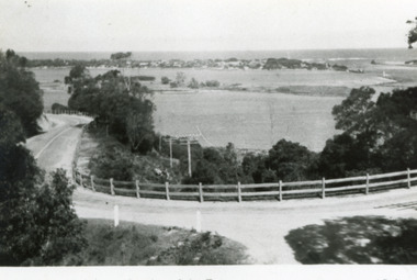
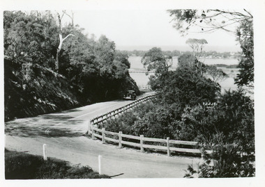
 Lakes Entrance Historical Society
Postcard, 1930c
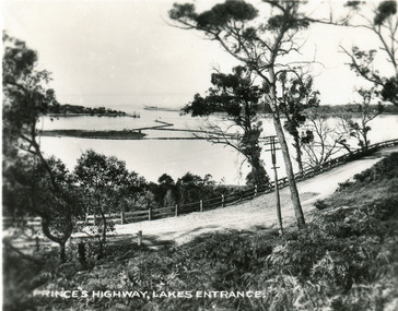
... , Bullock Island and rock groynes in the lake also entrance... and the post and rail guard fence, Bullock Island and rock groynes ...Also faded copy identical imageBlack and white small format postcard of the Princes Highway at Jemmys Point. It shows the road winding around the hill between the scrub covered hill and the post and rail guard fence, Bullock Island and rock groynes in the lake also entrance in distance. Lakes Entrance VictoriaPrinces Highway, Lakes Entranceislands, fences, roads and streets -
 Lakes Entrance Historical Society
Photograph - Tarpeena, Hammarstrom Ian, 1986 c
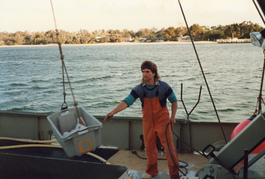
... Tarpeena at Co-op jetty, Bullock Island, shows deck hand Gerald..., Bullock Island, shows deck hand Gerald Rice at work during ...Colour photograph taken on the deck of fishing boat Tarpeena at Co-op jetty, Bullock Island, shows deck hand Gerald Rice at work during unloading of catch from fish well. Cunninghame Arm and New Works cottages in image. Lakes Entrance Victoriaships and shipping, fishing industry, people -
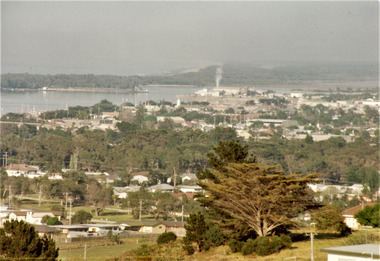 Lakes Entrance Historical Society
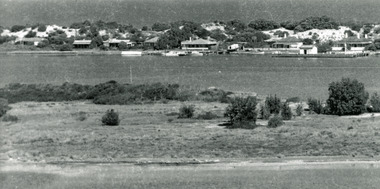
Photograph - Township, Fish Marie, 1985c
... Colour photograph of township, showing building on Bullock... of township, showing building on Bullock Island, Cunningham Arm ...Colour photograph of township, showing building on Bullock Island, Cunningham Arm and small white shed on old New Works Jetty near the entrance, view towards the barrier. Photo taken from near telecom tower on Merrangbaur Hill 1985c. Lakes Entrance Victoriatopography, township, waterways, bridges -
 Lakes Entrance Historical Society
Postcard - Views of Lakes Entrance c1970, John Engelander and Co Melbourne, 1970 c
... road to Bullock Island, Club Spit being formed, Hill 60 visible... North Arm old toilet block opposite road to Bullock Island, Club ...Princes Highway to town showing concrete bridge over North Arm . Also identical postcard with message on back in Spares boxColour postcard of view from Princes Highway to town showing concrete bridge over North Arm old toilet block opposite road to Bullock Island, Club Spit being formed, Hill 60 visible on outer barrier hummocks Lakes Entrance Victoriaroads and streets, township, waterways -
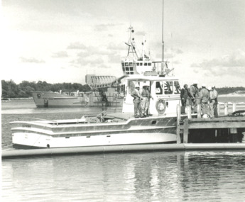
 Lakes Entrance Historical Society
Photograph - Lakes Tide and dredge Sandpiper at Fishermans Coop Lakes Entrance Victoria 1989
... Colour photograph of wharf at Bullock Island showing oil... photograph of wharf at Bullock Island showing oil rig supply vessel ...Colour photograph of wharf at Bullock Island showing oil rig supply vessel Lakes Tide and dredge Sandpiper at moorings Fishermans Coop building in background Thunderbird at New Works jetty in distance. Taken from dredge April Hamer Lakes Entrance Victoria 1989boats and boating, jetties, business, waterways -
 Lakes Entrance Historical Society
Photograph, Lakes Post Newspaper, Gippsland Ports vessel Latrobe Lakes Entrance Victoria, 1/11/1995 12:00:00 AM
... . Dredge April Hamer in background both moored at Bullock Island... moored at Bullock Island Lakes Entrance Victoria. Also photograph ...Black and white photograph of Gippsland Ports vessel Latrobe and crew taken on training day for Oil Spill disaster. Dredge April Hamer in background both moored at Bullock Island Lakes Entrance Victoria. Also photograph taken during Oil Spill disaster activities gippsland ports, events -
 Lakes Entrance Historical Society
Photograph, Glenice Soderlund, Lady Harriet barge, Lakes Entrance Victoria, 1/06/1989 12:00:00 AM
... at wharf in Cunninghame Arm mast and rigging intact. Bullock Island... intact. Bullock Island and sand dunes in background Lakes ...Colour photograph showing Lady Harriet barge moored at wharf in Cunninghame Arm mast and rigging intact. Bullock Island and sand dunes in background Lakes Entrance Victoria. Also an enlarged colour lamenated photograph almost identical 04673.1 29 x 19.5 cmbarges, boats and boating -
 Lakes Entrance Historical Society
Postcard - Princes Highway Kalimna, 1940c
... and rail guard fence. Glimpse of Bullock Island, lake and hummocks... and rail guard fence. Glimpse of Bullock Island, lake and hummocks ...Plus 3 identical black and white|Plus 2 tinted, (one tinted copy has inscription, 'Jemmy's Point')Black and white small format postcard of the road as it winds around Jemmys Point. It shows a motor car travelling up the hill between the steep cliff of the road cutting and the post and rail guard fence. Glimpse of Bullock Island, lake and hummocks in distance. Lakes Entrance Victoriafences, roads and streets, transport, coast -
 Lakes Entrance Historical Society
Photograph - Carpentertown, 1920c
... , part of Bullock Island showing some vegetation and one... of cottages, part of Bullock Island showing some vegetation and one ...Copied from a copy in possession of J WhadcoatBlack and white photograph showing view of seven cottages on dunes. View of several boats at jetties and on slipway, white shed on New Works wharf, Cunninghame Arm in front of cottages, part of Bullock Island showing some vegetation and one telegraph pole. Lakes Entrance Victoriawaterways, islands, settlement -
 Lakes Entrance Historical Society
Photograph - The Entrance, Fraser Ian, 1995c
... to the Gippsland Lakes. It shows the western end of Bullock Island.... It shows the western end of Bullock Island and the entrance ...Colour photograph of the entrance from Bass Strait to the Gippsland Lakes. It shows the western end of Bullock Island and the entrance to North Arm, cars parked on island and many people fishing. This area built up during dredging operations over many years. Lakes Entrance Victoria topography, fishing industry, boats and boating -
 Lakes Entrance Historical Society
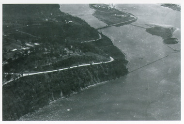
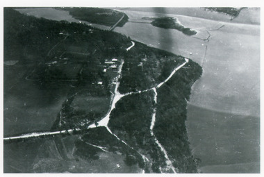
Photograph - Kalimna, Bulmer H D, 1940c
... to Bullock Island, and rock groynes. Track to lookout and signal... end of township, North Arm bridge, footbridge to Bullock ...Black and white photograph of aerial view of Kalimna Heights, showing scattered buildings, Princes Highway around side of cliff, western end of township, North Arm bridge, footbridge to Bullock Island, and rock groynes. Track to lookout and signal beacon visible. Lakes Entrance Victoria waterways, roads and streets, bridges, township -
 Lakes Entrance Historical Society
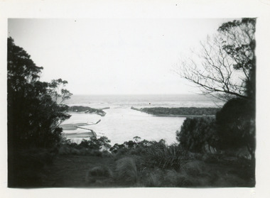
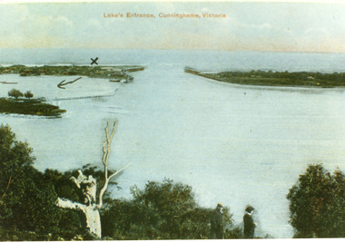
Postcard - The Entrance, 1900c
... and settlement at the entrance, Bullock Island and groynes to direct flow..., Bullock Island and groynes to direct flow of lake waters towards ...Also copy tinted postcard 10 x 15Coloured post card of the man made entrance through the sand dunes, taken from Jemmys Point. It shows the works and settlement at the entrance, Bullock Island and groynes to direct flow of lake waters towards entrance. Two men standing on Jemmys Point. Lakes Entrance VictoriaLakes Entrance, Cunninghame, Victoriaislands, waterways, topography -
 Lakes Entrance Historical Society
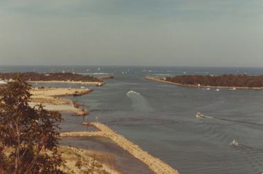
Photograph - The Entrance, 1920c
... . Navigation light on tip of Bullock Island on extreme right. Lakes... of Bullock Island on extreme right. Lakes Entrance Victoria ...Copied from photograph in possession of J WhadcoatBlack and white photograph showing stone piers at entrance to Gippsland Lakes from ocean - Bass Strait. Eastern pier on left, dune and western pier on right. Cranes and some work sheds on left. Navigation light on tip of Bullock Island on extreme right. Lakes Entrance Victoriajetties, waterways, topography, township -
 Lakes Entrance Historical Society
Photograph - Kalimna, Bulmer H D, 1940c
... bridge, footbridge to undeveloped Bullock Island with rock... to undeveloped Bullock Island with rock groynes in place. Part of eastern ...Black and white photograph of aerial view of Kalimna escarpment, Princes Highway, road to Kalimna Hotel, scattering of buildings including Gainsborough House, in distance is North Arm bridge, footbridge to undeveloped Bullock Island with rock groynes in place. Part of eastern pier of entrance at Lakes Entrance, Victoria. waterways, topography, township, bridges -
 Lakes Entrance Historical Society
Photograph - The Entrance, 1924c
... Works. West end of Bullock Island on left side of photo, bathing...Piers Islands Houses Black and white photograph showing ...Black and white photograph showing view from Jemmys Point of the entrance, with wooden piers, PWD houses and works buildings at New Works. West end of Bullock Island on left side of photo, bathing boxes and some trees on island, some rock groyne work at the entrance. Lakes Entrance Victoriapiers, islands, houses -
 Lakes Entrance Historical Society
Album - Photograph Album, Lady Harrietts Barge relocation,Lakes Entrance Victoria, 1995
... photographs showing relocation of Lady Harrietts Barge from Bullock... Harrietts Barge from Bullock Island to New Works precinct Lakes ...Small photograph album containing twenty three colour photographs showing relocation of Lady Harrietts Barge from Bullock Island to New Works precinct Lakes Entrance Victoria. Includes two colour photographs of toilets and two colour photographs of old machinery on concrete pad at New Workds areaenvironment, parks, public works -
 Lakes Entrance Historical Society
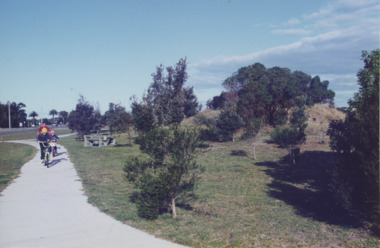
Photograph - Esplanade Lakes Entrance Victoria, Lakes Entrance Tidy Town, 1995 c
... and Bullock Island road. Middle distance left turn into Marine Parade... on pathway between south end of North Arm bridge and Bullock Island ...Colour photograph showing two children and an adult riding bicycles on pathway between south end of North Arm bridge and Bullock Island road. Middle distance left turn into Marine Parade foreground now site of skate park. In distance palm trees at entry to Esplanade Lakes Entrance Victoriarecreation, topography, roads and streets, parks -
 Lakes Entrance Historical Society
Photograph - The Entrance, Lakes Entrance Victoria. c 1979, G W Holding, 1/04/1979 12:00:00 AM
... filling on Bullock Island extension, Lakes Entrance Victoria. c... to North Arm and clay and gravel filling on Bullock Island ...Also a colour photograph of similar view of event named King of the Straits. Not held again at this venue due to dangerous conditions in Bass Strait. number 04234.1 size 9 x 13 cmColour photograph showing the Entrance, power boats in the ocean contestants in the Offshore Powerboat Race hosted by the Gippsland Lakes Boating Club, six power boats in the lake. Good view of rock groynes at entrance to North Arm and clay and gravel filling on Bullock Island extension, Lakes Entrance Victoria. c 1979 waterways, events, boats and boating -
 Lakes Entrance Historical Society
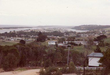
Photograph - Township
... west to Bullock Island and Rigby Island. Photo taken from near... and sand dunes on left. Looking west to Bullock Island and Rigby ...Colour photograph of township of Lakes Entrance showing North Arm, North Arm Bridge, Jemmys Point, Mount Barclay, Kalimna Heights, Cunningham Arm and sand dunes on left. Looking west to Bullock Island and Rigby Island. Photo taken from near Telecom Tower on Merrangbaur Hill. Lakes Entrance Victoria bridges, waterways, islands, township