Showing 470 items
matching caravan
-
 Ballaarat Mechanics' Institute (BMI Ballarat)
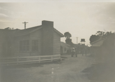
Begonia Festival Caravan
1960s, ballarat, begonia festival, caravan -
 Glenelg Shire Council Cultural Collection
Photograph - Photograph - View of Portland Harbour and port, c. 1980
Port of Portland Authority archives.Front: (no inscriptions) Back: (no inscriptions)port of portland archives, portland harbour, lighthouse, caravan park, south portland, aluminium smelter -
Clunes Museum
Plan - PLANS CLUNES CARAVAN PARK, NO. 1 - SHIRE OF TALBOT & CLUNES. IAN MANSLEY, SHIRE ENGINEER NO. 2 - LEO MCMAHON & ASSOCIATES PTY. LTD. LICENSED SURVEYORS & ENGINEERS, 31 LYONS ST. NTH. BALLARAT, 1976
NO. 1 PLAN - CLUNES CARAVAN PARK ENGINEER - IAN MANLEY NO. 2 PLAN - SECTION 15 TOWNSHIP OF CLUNES, COUNTY OF TALBOT, BY LEO MCMAHON AND ASSOCIATES, LICENSED SURVEYORS AND CIVIL ENGINEERSplans, caravan park, ian manley, plan section 15 -
 Old Colonists' Association of Ballarat Inc.
Photograph, Thornton Richards, Cottages at the Ballarat Old Colonists' Association Retirement Village, c1960
The Old Colonists' Association of Ballarat Inc Retirement Village is located at Charles Anderson Grove.Thirteen black and white cottages at the Ballarat Old Colonists' Association Retirement Village in Charles Anderson Grove, off Gillies Street. The retirement village is next to a caravan park, and Garden Court. old colonists' association ballarat, charles anderson grove, retirement village, garden court, caravan park, wendouree -
 Old Colonists' Association of Ballarat Inc.
Photograph, Thornton Richards, Cottages at the Ballarat Old Colonists' Association Retirement Village, c1960
The Old Colonists' Association of Ballarat Inc Retirement Village is located at Charles Anderson Grove.Thirteen black and white cottages at the Ballarat Old Colonists' Association Retirement Village in Charles Anderson Grove, off Gillies Street. The Caravan Park and Garden Court is also evident in the photograph.old colonists' association ballarat, charles anderson grove, retirement village -
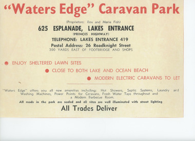 Lakes Entrance Historical Society
Album - Waters Edge Camp Park, Marie Fish, 1962 to 1975
Park owned by Rex and Marie FishAdvertisement for Waters Edge Caravan Park in first page of brown covered photograph album with 60 photographs of building and early days of Waters Edge Camp Park Lakes Entrance Victoriabusinesses, camping, tourism -
Clunes Museum
Newspaper - NEWSPAPER CUTTING, BALLARAT COURIER PTY. LTD
JAMES WILLIAM ESMOND MONUMENT.NEWSPAPER CUTTING FROM THE SUPPLEMENT TO THE BALLARAT COURIER, WITH A SCENE OF THE FIRST GOLDSTRIKE IN VICTORIA AND A PHOTO OF JAMES WILLIAM ESMOND MONUMENT AT CLUNES MARKING THE DISCOVERY OF GOLD THERE IN JULY 1851.ADVERTISEMENTS OF WILLIAM BARKELL ART & HISTORICAL CENTRE, CLUNES NEWSAGENTS, CLUNES LICENSED GROCER, NATIONAL HOTEL, MOTEL, CLUB HOTEL, CARAVAN PARK, ETC.local history, document, newspaper cutting, mining, monument -
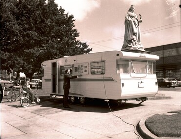
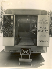
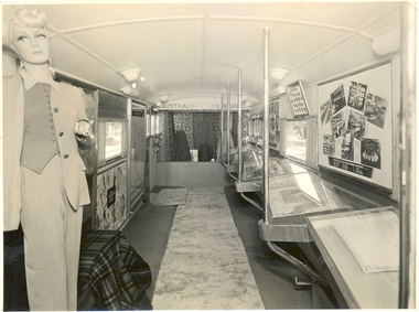 National Wool Museum
Photograph
The Australian Wool Board promotional caravanRitter-Jepperson Studios...wool marketing fashion, australian wool board australian wool board - wool marketing committee, retsol rugs, wool marketing, fashion -
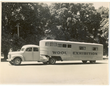
 National Wool Museum
Photograph
The Australian Wool Board promotional caravanRitter-Jepperson Studios...wool marketing fashion, australian wool board australian wool board - wool marketing committee, wool marketing, fashion -
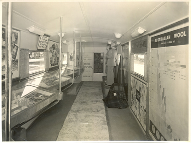
 National Wool Museum
Photograph
The Australian Wool Board promotional caravanRitter-Jepperson Studios...wool marketing fashion, australian wool board australian wool board - wool marketing committee, wool marketing, fashion -
 National Wool Museum
Photograph
The Australian Wool Board promotional caravanRitter-Jepperson Studios...wool marketing fashion, australian wool board australian wool board - wool marketing committee, retsol rugs, wool marketing, fashion -
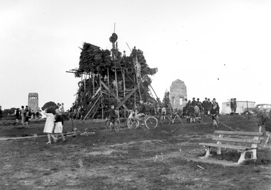 Surrey Hills Historical Society Collection
Photograph, Bonfire, Beckett Park, Balwyn (Surrey Hills), c1937/8, 1937
"The bonfire at Beckett Park was the culmination of the EMPIRE DAY/CELEBRATIONS in Surrey Hills in 1935 and 1936. In 1937 vandals lit the fire prematurely but residents hastily rebuilt it - about / 100 tons including old tyres. A volunteer fire-watcher had his caravan close by until lights-up time on Saturday night. / Courtesy Ian Barkla. / see 180 (handwritten on backing board)." / "BONFIRE BUILDING at BECKETT PARK/EMPIRE DAY CELEBRATIONS IN 1930s/ The celebrations were centred on the/ shopping centres in Surrey Hills and/Mont Albert to boost local business (and/ the spirits of residents) after the Depression./ - from a glass negative - Mr Ian Barkla."Image depicting the building of a large bonfire made primarily from rubber tyres, supported by a wooden frame c1937/8. There is a significant crowd of people watching the erection of the pyre from ground level. Several members of the crowd are seated or holding bicycles. There are multiple persons situated on the pyre or on a ladder propped up against the mound of tyres. The area containing the pyre has been fenced off with rope (?). A white coloured caravan in situated to the right (facing) of the bonfire in close proximity to a dark coloured car. Two stone towers and a park bench are also visible in the image.Black and white, W 25.3 cm x H 20.3 cm, landscapeparks and reserves, beckett park, balwyn, bicycles, crowds, empire day, depression 1929-1939, economic depression, frank leslie barkla, bonfires -
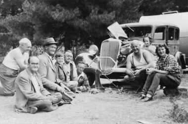 Halls Gap & Grampians Historical Society
Photograph - B/W, C 1946
The woman on the right is Mrs Nally, nee Lawson. The man next to her is her husband Pat Nally (a policeman from Port Fairy). The young girl is Patricia Nally. The man lying on the ground next to the car is William Parfett. next to him is (?) Lawson, the boy is either David or Robert Parfett (they were twins). The photo was taken at Zumsteins Campground.The photo shows a group of people (six men, one boy, one woman and one girl) seated and kneeling around a car and caravan. The car bonnet it raised and there is a man's hat sitting on the right headlight.people, tourists -
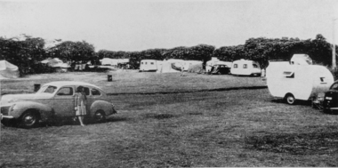 Torquay and District Historical Society
Photograph (copy), Early Torquay Beach Scenes
Photograph shows the caravan park at Torquay front beach.A snapshot of past holidays at the beach.Black and white photographtorquay foreshore caravan park -
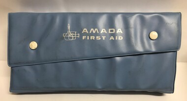 Greensborough Historical Society
First Aid Kit, Amada First Aid, 1960c
First aid kit possibly used by travellers in a car and/or caravan.First aid kit comprising scissors, magnifying glass, tweezers, bandages and medications in blue press-stud plastic pack. (Torniquet and antiseptic cream missing)first aid kits -
Clunes Museum
Document, MINUTES FOR PUBLIC MEETING HELD IN THE TOWN HALL CLUNES ON 23/2/1971, 23/02/1971
THIS PUBLIC MEETING WAS TO CONSIDER THE FOLLOWING; HOLDING OF A "BACK TO CLUNES", CONSTRUCTION OF A CARAVAN PARK AND CONSTRUCTION OF A SCENIC TOURISE ROAD FROM ANGUS STREET TO FRASER STREET VIA "THE ROCKS" THIS RESULTED IN THE ELECTION OF A "BACK TO CLUNES" COMMITTEE AND THE" SCENIC ROAD AND CARAVAN PARK COMMITTEE".2 X FOOLSCAP PAGES OF THE COPY OF MINUTES HELD IN THE TOWN HALL, CLUNES ON 23/2/1971local history, local government, council, events and celebrations, back to clunes, scenic road and caravan park committee -
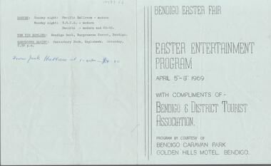 Bendigo Historical Society Inc.
Document - BENDIGO EASTER FAIR COLLECTION: EASTER ENTERTAINEMNT PROGRAM 1969
Four pages Bendigo Easter Fair - Easter Entertainment Program: April 5th-8th 1969. With the compliments of Bendigo & District Tourist Association. Program by courtesy of Bendigo caravan park - Golden Hills Motel, Bendigo.event, easter fair, bendigo easter fair -
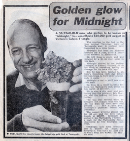 Tarnagulla History Archive
News clipping: Golden glow for Midnight, Golden glow for Midnight, 21 July, 1982
Murray Comrie Collection. A news clipping from The Sun newspaper about a man known as Midnight finding a gold nugget. Midnight lived in a caravan behind the Tarnagulla pub. Quotes publican Eric Morris. Image of Eric Morris with the nugget.tarnagulla, gold, prospecting, people, residents, eric morris, midnight, nuggets, hotels -
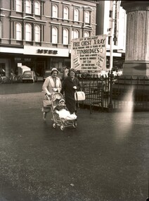 Ballaarat Mechanics' Institute (BMI Ballarat)
Chest X ray sign Sturt St
1960s, ballarat, chest xray, caravan, sturt st -
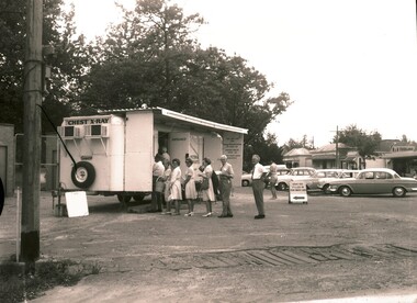 Ballaarat Mechanics' Institute (BMI Ballarat)
Chest Xray Caravan
1960s, ballarat, chest, xray, caravan -
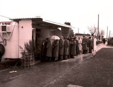 Ballaarat Mechanics' Institute (BMI Ballarat)
Chest Xray Caravan 2
1960s, ballarat, chest, xray, caravan -
 Phillip Island and District Historical Society Inc.
Photographs, Gary Field, 1963
Photographs taken by Gary Field. Lady in photos is Gary's mother. She planted Angophora trees near corner of Daffyd Street and Appley Avenue. (Information supplies by John Eddy).Four black & white photographs of panoramic views from and of Daffyd Street, Red Rocks in 1963, looking north with French Island and the Peninsula on the horizon, view of houses and caravans in Daffyd Street and showing local scrub and housing.daffyd street red rocks, red rocks phillip island, houses 1960's, gary field -
Tatura Irrigation & Wartime Camps Museum
Booklet, Dhurringile and The Delle's, 2001
Written to record family history of life on Dhurringile farm and early history of tomato growng at Dhurringile and TaturaInside a plastic bag. White cover, brown writing, blue border. Sketches of caravan truck, tomato, fish, farmer, cow, dog, snake. Photo of truck used for delivering tomatoes to Melbourne market on back coverdhurringile, dell vergin family, tatura, tomato industry, books, history, local, rural, industries -
Peterborough History Group
Peterborough Foreshore Committee Records
Records about the running of the Foreshore Reserve, including the playground and the development of the Caravan Park.Significant as it includes information about the establishment, maintenance and running of the caravan park, including a list of names of bookings in 1958. Also information about the construction of the river boat ramp and the town playground. Correspondence about a request by the Foreshore Committee to include land to the west of Peterborough but which was subsequently adopted by National Parks. It is interesting to note the names of Committee members and the changes over time. Storage box containing various documents pertaining to the running of the Foreshore Committee including cheque book, copies of correspondence, receipts and financial records.peterborough, great ocean road, camping, curdies river -
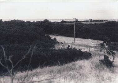
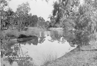 Stawell Historical Society Inc
Photograph, Botanical Reserve in Stawell West
Botanical Reserve Stawell West. Now called The Grampian Gate Caravan Park.Black and white photograph of lake with trees around the edges.Botanical Reserve Stawell.stawell -
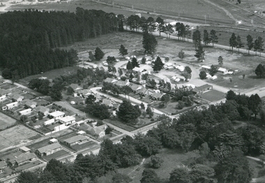
 The Beechworth Burke Museum
Photograph, 1960s
This photograph was taken in the 1960s at Lake Sambell Caravan Park and visible in the photograph are individual caravan sites with electricity outlets, a large single-story building with a caravan park banner, dirt roads, a freestanding message board, and a parked car. Lake Sambell Caravan Park opened in 1959 owing to the work of R.E. Carter, Beechworth Shire engineer from 1954-63. Carter advocated for improvements to the lake and surrounding area in order to encourage tourism in Beechworth. The opening of the caravan park was part of many improvements to Lake Sambell made in this period by Carter including: the swimming pool in 1961, water skiing and boating facilities, and increased lake surface in 1964. These improvements were financed mainly by grants from the Tourist Development Authority. The popularity of caravanning in Australia exploded during this post-war period of the late 1950s and 1960s. This popularity was driven by multiple factors, including: the stopping of fuel rations, the accessibility of car ownership through the manufacturing of affordable cars, technological developments in caravan design, and the increase in prosperity and leisure time for many Australians. Facilities such as electrical outlets to power caravans are present in this photograph of Lake Sambell Caravan Park. Lake Sambell is an artificial lake that was developed on the previous site of the Rocky Mountain Mining Company workings and was officially opened by Minister for Lands, Mr Baily, on October 5, 1928. The disused and unattractive remains of the mine were converted into a recreational area intended for swimming, boating, and fishing. The lake is named after Mr L.H. Sambell, shire engineer and secretary of the Forward Beechworth Committee, who advocated for the enhancement of Beechworth into a tourist destination and was central to the planning and establishment of the lake. This photograph is of historical and social significance in providing insight into caravanning during the 1960s in Australia. Caravanning was extremely popular during the 1960s in Australia due to multiple social and economic factors including the stopping of fuel rations, the accessibility of car ownership through the manufacturing of affordable cars, technological developments in caravan design, and the increase in prosperity and leisure time for many Australians.Black and white rectangle photograph printed on photographic paper and unmounted.Reverse: 3536/ [logo back printing: KODAK/ VELOX/ PAPER] / C798 lake sambell caravan park, lake sambell, caravanning 1960s, caravan park, rocky mountain mining company, kodak velox paper, r.e. carter, l.h. sambell, caravan electricity outlets, tourist development authority, post-war prosperity, forward beechworth committee, lake sambell boating, lake sambell swimming pool, lake sambell fishing, artificial lake, travel 1960s, recreation 1960s -
 The Beechworth Burke Museum
Photograph, 1960s
This photograph was taken in the 1960s at Lake Sambell Caravan Park, visible in the photograph are individual caravan sites with electricity outlets, a large single-story building, a parked car, and two caravans partially obstructed by trees. Lake Sambell Caravan Park opened in 1959 owing to the work of R.E. Carter, Beechworth Shire engineer from 1954-63. Carter advocated for improvements to the lake and surrounding area in order to encourage tourism in Beechworth. The opening of the caravan park was part of many improvements to Lake Sambell made in this period by Carter including: the swimming pool in 1961, water skiing and boating facilities, and increased lake surface in 1964. These improvements were financed mainly by grants from the Tourist Development Authority. The popularity of caravanning in Australia exploded during this post-war period of the late 1950s and 1960s. This popularity was driven by multiple factors, including: the stopping of fuel rations, the accessibility of car ownership through the manufacturing of affordable cars, technological developments in caravan design, and the increase in prosperity and leisure time for many Australians. Facilities such as electrical outlets to power caravans are present in this photograph of Lake Sambell Caravan Park. Lake Sambell is an artificial lake that was developed on the previous site of the Rocky Mountain Mining Company workings and was officially opened by Minister for Lands, Mr Baily, on October 5, 1928. The disused and unattractive remains of the mine were converted into a recreational area intended for swimming, boating, and fishing. The lake is named after Mr L.H. Sambell, shire engineer and secretary of the Forward Beechworth Committee, who advocated for the enhancement of Beechworth into a tourist destination and was central to the planning and establishment of the lake. This photograph is of historic and social significance in documenting the enhancement of the Lake Sambell area overseen by R.E. Carter and providing insight into caravanning during the 1960s in Australia. Caravanning was extremely popular in Australia during the late 1950s and 60s due to multiple social and economic factors including the stopping of fuel rations, the accessibility of car ownership through the manufacturing of affordable cars, technological developments in caravan design, and the increase in prosperity and leisure time for many Australians. Black and white rectangle photograph printed on photographic paper and unmounted.Reverse: 3538/ [logo back printing KODAK/ VELOX/ PAPER] / C798lake sambell caravan park, lake sambell, lake sambell 1960s, lake sambell fishing, lake sambell boating, lake sambell swimming pool, r.e. carter, l.h. sambell, tourist development authority, caravanning 1960s, caravan electricity outlets, caravan park, forward beechworth committee, rocky mountain mining company, lake caravan park, caravan mid 20th century, beechworth tourism, travel in the 1960s, holiday 1960s -
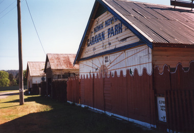 Lakes Entrance Historical Society
Photograph - Nowa Nowa Caravan Park, 1999
Colour photograph of a building at the Nowa Nowa Caravan Park, a weatherboard building with gable corrugated iron roof. Also in photograph two buildings, one of which was Hodder's Store and the other which used to be the bakehouse. Nowa Nowa Victoriacamping, buildings -
 Port Fairy Historical Society Museum and Archives
Photograph
Moyne river bridge photograph taken in 1956 showing Blakes caravan park in backgroundColoured landscape of the Moyne River bridge taken from the balcony of the house (Riverside) on the corner of Regent Street and Gipps street From Tom Bartlett's Gipps Street looking East over bridge 1956bridge, moyne river, traffic, gipps street -
 Lakes Entrance Historical Society
Photograph - Camp Park, 1949
Also two other black and white photographs taken at park in a caravan 05437.1 and 5437.2Black and white photograph of entry to holiday park Lakes Entrance Victoriacamping, businesses, tourism