Showing 3916 items
matching creek street
-
 Stawell Historical Society Inc
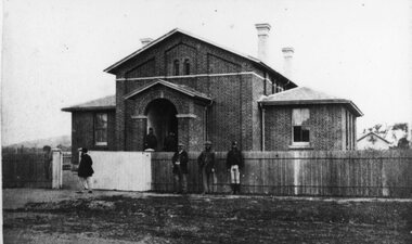
Photograph, Pleasant Creek Court House in Longfield Street Stawell with Constables in front 1880
... Pleasant Creek Court House Longfield Street 1880 Constables... grampians Pleasant Creek Court House Longfield Street 1880 ...Pleasant Creek Court House Longfield Street 1880 Constables in frontstawell government -
 Eltham District Historical Society Inc
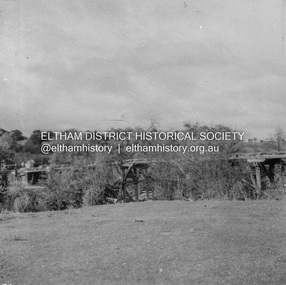
Negative - Photograph, George W. Bell, Foot Bridge to Eltham High School, c.1960
... Footbridge over the Diamond Creek at Dalton Street near... melbourne Footbridge over the Diamond Creek at Dalton Street near ...Footbridge over the Diamond Creek at Dalton Street near Withers Way. It has since been replaced and integrated into the Wingrove Park Trail.This photo forms part of a collection of photographs gathered by the Shire of Eltham for their centenary project book,"Pioneers and Painters: 100 years of the Shire of Eltham" by Alan Marshall (1971). The collection of over 500 images is held in partnership between Eltham District Historical Society and Yarra Plenty Regional Library (Eltham Library) and is now formally known as the 'The Shire of Eltham Pioneers Photograph Collection.' It is significant in being the first community sourced collection representing the places and people of the Shire's first one hundred years.Digital image 4 x 5 inch B&W Negsepp, shire of eltham pioneers photograph collection, eltham, eltham high school, foot bridge, bridge, dalton street, diamond creek (creek), george w. bell collection, wingrove park trail, withers way -
 Eltham District Historical Society Inc
Photograph, Looking north along Main Road from Cecil Street intersection, Eltham, February 1968, Feb 1968
... under railway line to the Diamond Creek and Cecil Street sign.... under railway line to the Diamond Creek and Cecil Street sign ...Shows position of under road water course, which also went under railway line to the Diamond Creek and Cecil Street sign.In February 1968 an unknown person took a series of photos from the Eltham Hotel at Pitt Street heading north along Main Road through the shopping centre to just north of Elsa Court covering the length of the section of Main Road which was duplicated shortly thereafter. Shows the condition and environment of the streesscape of Main Road, Eltham immediately prior to the duplication between Pitt Street and Elsa Court through the shopping centre. Also shows a number of shops and businesses that operated at that time.Black and white photographduplication, eltham, main road, cecil street, railway line, watercourse, floods -
 Bendigo Historical Society Inc.
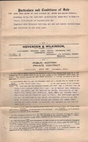
Document - H.A. & S.R. WILKINSON COLLECTION: CONDITION OF SALE
... Creek and Haman Streets Bendigo together with 5-roomed dwelling... Inc. History House 11 Mackenzie Street Bendigo goldfields ...Condition of sale by private contract dated 14th. December, 1928 between G. J. Wilkinson and M. Berry for land at corner Creek and Haman Streets Bendigo together with 5-roomed dwelling for the price of 350 pounds.organization, business, h.a. & s.r wilkinson real estate -
 Bendigo Historical Society Inc.
Print - ETCHING OF VIEW STREET SANDHURST 1859, 1859
... over creek. View street going towards Barnard street... Inc. History House 11 Mackenzie Street Bendigo goldfields ...Black and white etching of View Street buildings. Dudley House. Mechanics Institute. Henry Jackson. Pikes bridge with children crossing. Horses & carts. People walking. Timber slats over creek. View street going towards Barnard street. Etching copy of original. View Street. Sandhurst. 1859. Survey & Post Office. FH 566 Not Found 8.12.2022place, bendigo, view street buildings. 1859 -
 City of Greater Bendigo - Civic Collection
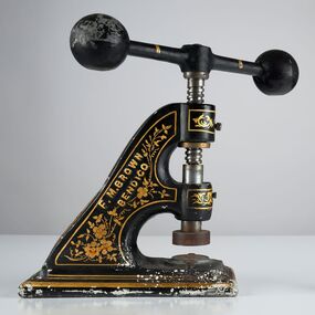
Ceremonial object - Common Seal, F M Brown & Co Foundry
... ) on the corners of Creek and High Street in Bendigo. This embosser...) on the corners of Creek and High Street in Bendigo. This embosser ...F. M. Brown & Co were a foundry located (in 1892) on the corners of Creek and High Street in Bendigo. This embosser was manufactured by them for the City of Bendigo. Large, decorated, hand operated cast iron embosser with an top iron winder. Winder has a large knob on each end and when turned lowers and raises the seal. Embosser is decorated with a layer of plaster with is black with gold hand painted decorations including scrolls and flowers. Object is extremely heavy. Seal head is still attached and holds the embossing stamp for the City of Bendigo. 'F.M Brown Bendigo' on both sides of the embosser 'City of Bendigo' on seal head.city of bendigo commerce -
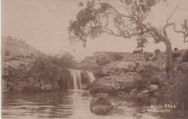 Sunbury Family History and Heritage Society Inc.
Photograph
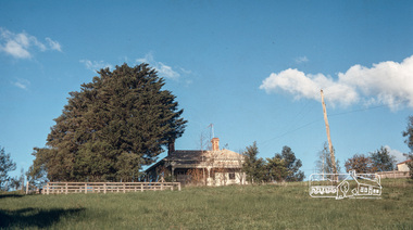
... The Mill Falls are downstream on the Jacksons Creek from... Street bridge in Sunbury. Jacksons Creek Mill Falls sunbury MILL ...The Mill Falls are downstream on the Jacksons Creek from the Macedon Street bridge in Sunbury.A sepia photograph in post card format of a river with a waterfall. A straggly tree is growing on the bank on the RHS of the photograph.MILL FALL/ SUNBURYjacksons creek, mill falls, sunbury -
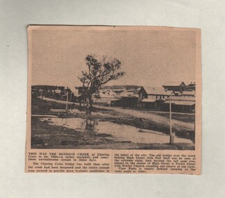 Bendigo Historical Society Inc.
Document - BASIL MILLER COLLECTION: TRAMS - BENDIGO CREEK AT CHARING CROSS
... in the 1860's. Shows old bridge over creek linking High Street... Inc. History House 11 Mackenzie Street Bendigo goldfields ...Newspaper clipping, date unknown, with photograph taken in the 1860's. Shows old bridge over creek linking High Street and Pall Mall. Indicates location of Forest Street, and shows Wesley Church to the in centre left background.person, individual, basil miller -
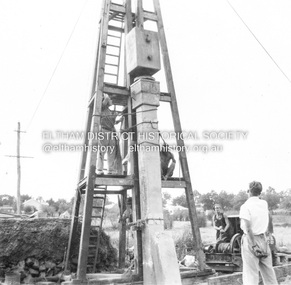 Eltham District Historical Society Inc
Album - Photograph, J.A. McDonald, Eltham-Greensborough Road, 1957
... Diamond Creek Bridge (Bridge Street Bridge) Inner Vertical... melbourne Diamond Creek Bridge (Bridge Street Bridge) Inner Vertical ...Diamond Creek Bridge (Bridge Street Bridge) Inner Vertical pile downstream side Eltham abutment This pile appalled at head after this blow. 1957Record of various Shire of Eltham infrastructure works undertaken during the period of 1952-1962 involving bridge and road reconstruction projects, sometimes with Eltham Shire Council Project Reference numbers quoted. It was during this period that a number of significant improvements were made to roads and new bridges constructed within the shire that remain in place as of present day (2022). In many situations, the photos provide a tangible visible record of infrastructure that existed throughout the early days of the Shire. The album was put together by or under the direction of the Shire Engineer, J.A. McDonald.infrastructure, road construction, shire of eltham, bridge construction, bridge street bridge, eltham, eltham-greensborough road, 1957 -
 Stawell Historical Society Inc
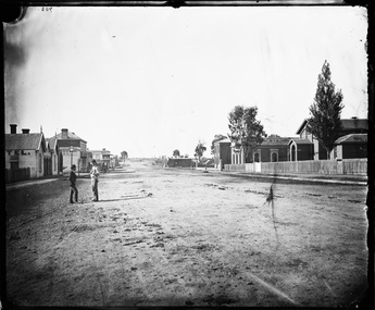
Photograph, Longfield Street Stawell with buildings on both sides Holtermann Photograph April 1874, by Charles Bayliss of American and Australasian Photograph Co
... Pleasant Creek Longfield Street Scene looking South... pleasant creek hotels Pleasant Creek Longfield Street Scene looking ...Part of Holtermann Collection Ref FL1253748.Pleasant Creek Longfield Street Scene looking South. Hotels on left Camp Hotel, Constitution Hotel and Shamrock Hotel on other side of Seaby Street. Pleasant Creek Court House, Shire Hall and Literary Institute on Right. Smith's Store in distance on right, on other side of Seaby Street. Note two wire telegraph poles in distance along side of road beyond Smiths Store. One of the two gentlemen talking is Merlin's photographic assistant Charles Bayliss who toured the Victorian Gold towns producing photographs for American Australasian Photographic Company. From State Library NSW records, Holtermann's Collection. stawell, pleasant creek, hotels -
 Stawell Historical Society Inc
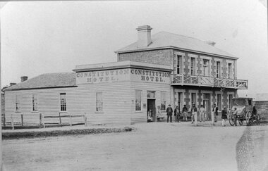
Photograph, Constitution Hotel in Longfield Street Pleasant Creekwith a Cob & Co Coach at the front c1866
... Constitution Hotel Longfield Street Pleasant Creek. Cob... grampians Constitution Hotel Longfield Street Pleasant Creek. Cob ...Constitution Hotel Longfield Street Pleasant Creek. Cob & Co Coach at front. c1866stawell -
 Falls Creek Historical Society
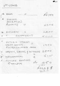
Document - Motel Planning - Hand-Written Figures - 1st Stage; 2nd Stage; Deletions
... , Christie Street, Falls Creek.... for a new chalet on Site 4, Christie Street, Falls Creek. Motel ...Bob (Herman) Hymans (a former member of the Royal Netherlands Navy) was born in Bloemendaal, Holland on 30th September 1922. During World War II he fought against the Japanese in the Dutch East Indies (now Indonesia) and was imprisoned in Changi and on the Burma Railway. After gaining qualifications as a Ski Instructor, Bob arrived in Falls Creek in July 1950. Working as an Instructor and Supervisor at Bogong Lodge, Bob decided his future was in accommodation. He was successful in negotiating an indenture for land from the State Electricity Commission (SEC). It took Bob two years to build his Grand Coeur Chalet but, tragically, it was burned down in August 1961. Bob also built the first Chairlift in Australia. This was a single chairlift and the structure was built from wooden electricity poles. He was constantly full of new ideas and proposals for the village. Bob Hymans died on 7th July 2007. This Collection of documents and letters tells the story of Bob's endeavours to develop Falls Creek into the ski village it is today.This Collection of documents and letters tells the story of Bob’s endeavours to develop Falls Creek into the ski village it is today. 6 sheets of handwritten notes recording cost estimates for different stages of Mr Hymans' plans for a new chalet on Site 4, Christie Street, Falls Creek.falls creek tourist area management committee, bob hymans, falls creek administration -
 Eltham District Historical Society Inc
Album - Photograph, J.A. McDonald, Eltham-Greensborough Road, 27 July 1956
... Diamond Creek Bridge (Bridge Street Bridge) Downstream... melbourne Diamond Creek Bridge (Bridge Street Bridge) Downstream ...Diamond Creek Bridge (Bridge Street Bridge) Downstream cylinder pier No. 1 showing concrete slurry and rock fault. Paul Krafeznk 27th July 1956Record of various Shire of Eltham infrastructure works undertaken during the period of 1952-1962 involving bridge and road reconstruction projects, sometimes with Eltham Shire Council Project Reference numbers quoted. It was during this period that a number of significant improvements were made to roads and new bridges constructed within the shire that remain in place as of present day (2022). In many situations, the photos provide a tangible visible record of infrastructure that existed throughout the early days of the Shire. The album was put together by or under the direction of the Shire Engineer, J.A. McDonald.infrastructure, road construction, shire of eltham, bridge construction, bridge street bridge, eltham, eltham-greensborough road, 1956-07-26, paul krafeznk -
 Bendigo Historical Society Inc.
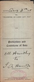
Document - H.A. & S.R. WILKINSON COLLECTION: CONDITION OF SALE
... of Creek and Thistle Streets, Bendigo held under miners right.... A. Hunter for land at the corner of Creek and Thistle Streets ...Particulars and conditions of sale dated 3rd. August, 1928 between M. Huntley and S. A. Hunter for land at the corner of Creek and Thistle Streets, Bendigo held under miners right No. 6128 and being residence area No. 18124 for the price of 16 pounds and 10 shillingsorganization, business, h.a. & s.r wilkinson real estate -
 Eltham District Historical Society Inc
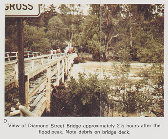
Work on paper (Sub-Item) - Photograph, Flooding, View of Diamond Street Bridge, Eltham 8 April 1977
... Colour photograph. Flooding of Diamond Creek at Diamond... diamond creek flooding eltham Diamond Street bridge Image printed ...Colour photograph. Flooding of Diamond Creek at Diamond Street Eltham bridge approximately 2 1/2 hours after the flood peak. Note debris on the bridge deck. 8 April 1977. flood, diamond creek, flooding, eltham, diamond street, bridge -
 Bendigo Historical Society Inc.
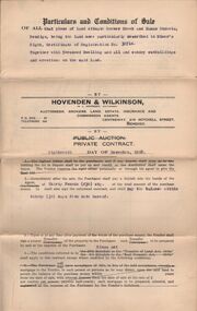
Document - H.A. & S.R. WILKINSON COLLECTION: CONDITION OF SALE
... at corner of Creek and Haman Streets Bendigo described in Miner's... Inc. History House 11 Mackenzie Street Bendigo goldfields ...Condition of sale by private contract dated 18th. December, 1928 between H. A. Wilkinson and D. R. Hay for block of land at corner of Creek and Haman Streets Bendigo described in Miner's right certificate No. 30714 together with 5-roomed dwelling for the price of 340 pounds.organization, business, h.a. & s.r wilkinson real estate -
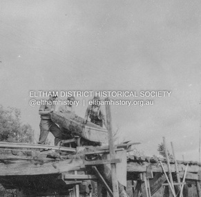
 Eltham District Historical Society Inc
Album - Photograph, J.A. McDonald, Eltham-Greensborough Road, 26 July 1956
... Diamond Creek Bridge (Bridge Street Bridge) Old bridge from... melbourne Diamond Creek Bridge (Bridge Street Bridge) Old bridge ...Diamond Creek Bridge (Bridge Street Bridge) Old bridge from N.W. bank Handrails stripped – 26/7/56 View looking west along bridge to Susan Street intersection with barriers placed across the roadRecord of various Shire of Eltham infrastructure works undertaken during the period of 1952-1962 involving bridge and road reconstruction projects, sometimes with Eltham Shire Council Project Reference numbers quoted. It was during this period that a number of significant improvements were made to roads and new bridges constructed within the shire that remain in place as of present day (2022). In many situations, the photos provide a tangible visible record of infrastructure that existed throughout the early days of the Shire. The album was put together by or under the direction of the Shire Engineer, J.A. McDonald.infrastructure, road construction, shire of eltham, bridge construction, bridge street bridge, eltham, eltham-greensborough road, 1956-07-26 -
 Eltham District Historical Society Inc
Photograph, Fred Mitchell, Sunnyside, 82 Bible Street, Eltham, 1968, 1968
... the land looking west from the house to the Diamond Creek. Hence... the land looking west from the house to the Diamond Creek. Hence ...Original home of W.J. Taylor and family who owned all the land looking west from the house to the Diamond Creek. Hence, Taylor Street. Located on top of the hill, the home was built c.1885 and still stands today (No. 82). Digital copy of colour photographfred mitchell collection, 1968, bible street, eltham, houses, w.j. taylor, sunnyside -
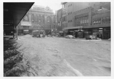 Melbourne Tram Museum
Photograph - Set of 5 black and white - Elizabeth St flood, Peter Duckett, 17-2-1972
... Market and the former creek bed of Elizabeth Street acting... and the former creek bed of Elizabeth Street acting as a drain. Cars ...Shows the impact of a major rain event near the Victoria Market and the former creek bed of Elizabeth Street acting as a drain. Cars floated and trams were damaged.Yields information about a major rain event in Elizabeth St during 1972 and the impact it had on vehicles and tramway operations.Set of five black and white photographs of major flooding in Elizabeth St 17-2-1972. Copied by the donor from negatives provided by the photographer.floods, elizabeth st, tramways, events, trams, melbourne -
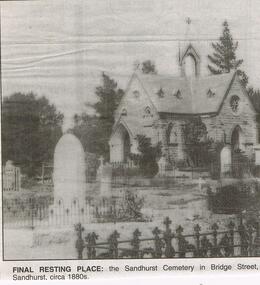 Bendigo Historical Society Inc.
Newspaper - JENNY FOLEY COLLECTION: FINAL RESTING PLACE
... is at the Back Creek Cemetery in Carpenter Street Bendigo.... Inc. History House 11 Mackenzie Street Bendigo goldfields ...Bendigo Advertiser "The way we were" from 1999. Final resting place: the Sandhurst cemetery in Bridge Street, Sandhurst, circa 1880s. NOTE: Photo incorrectly labelled. This chapel is at the Back Creek Cemetery in Carpenter Street Bendigo.newspaper, bendigo advertiser, the way we were -
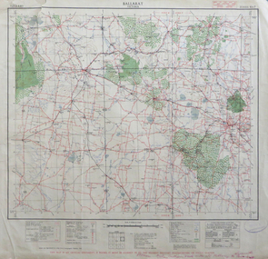 Federation University Historical Collection
Map, Ballarat, Victoria, 1942, 1942
... Creek, Leigh River, Fiery Creek, Hopkins River. Street names..., Skipton, Mount Emu Creek, Leigh River, Fiery Creek, Hopkins River ...Two copies of a map of the district around Ballarat, including Creswick, Scarsdale, Smythesdale, Lake Bolac, Ararat, Talbot, Sebastopol, Maryborough, Cardigan, Skipton, Mount Emu Creek, Leigh River, Fiery Creek, Hopkins River. Street names are listed on the back of the map. It includes roads, timber, creeks, rivers, telephone lines, railwayPrinted in red at the base of the map "This map is an official document. If found, itmust be handed in to the nearest Military Headquarters or Police Station.ballarat, map, world war two, skipton, creswick, ararat, lake bolac -
 Bacchus Marsh & District Historical Society
Map, Maddingley Township, Parish of Parwan, 1880s
... A single page paper map showing land allotments, streets... A single page paper map showing land allotments, streets, rivers ...This map is dated Sept. 6th 1856. However places in the township of Maddingley which did not appear until the late 1880s such as the Bacchus Marsh Railway Station and line are shown on this map in their correct locations. This suggests the map has been derived from an earlier map. An earlier date of 1843 with a surveyor's name preceding it can also be seen on the map. The map is important because it indicates the location and dimensions of early but now discontinued use of land such as the showgrounds and police paddock and a site reserved for the Church of England which was not ultimately used for a permanent church. A single page paper map showing land allotments, streets, rivers, creeks, park lands, the railway line and Bacchus Marsh railway station in the township of Maddingley. The map is pasted into a bound volume containing 76 maps or plans in total. Bottom of Map: Surveyor-General's Office, Melbourne, Sept 6th, 1856bacchus marsh victoria maps, maddingley victoria maps, land use, maddingley victoria history -
 Bacchus Marsh & District Historical Society
Map, Maddingley Township, Parish of Parwan, circa 1890s
... A single page paper map showing land allotments, streets... showing land allotments, streets, rivers, creeks, park lands ...Maddingley is a locality or township within the broader township area of Bacchus Marsh. This map is not dated. However features in Maddingley which appeared in the 1880s and 1890s are present in the map, These include the Bacchus Marsh Railway Station and the Bacchus Marsh Showgrounds. The main residential and commercial area of Maddingley is shown on this map in an area bounded by Bacchus Street, Barry Street, Griffith Street and Maddingley Road. Other streets visible are Franklin Street, Inglis Street, Labilliere Street, McCrae Street, Moore Street and part of Station Street.A single page paper map showing land allotments, streets, rivers, creeks, park lands, the railway line and Bacchus Marsh railway station in the township of Maddingley. The map is pasted into a bound volume containing 76 maps or plans in total. bacchus marsh victoria maps, maddingley victoria maps, land use, maddingley victoria history -
 Hume City Civic Collection
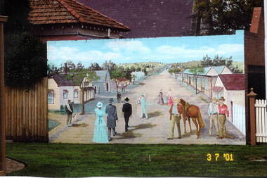
Photograph, Sunbury Mural, 3rd July 2001
... opened in Sunbury in Macedon Street between Jacksons Creek... opened in Sunbury in Macedon Street between Jacksons Creek ...The mural of the artist's image of early Sunbury was painted on the garage wall of the Sunbury Presbytery. It could be viewed from the former court house garden. The first businesses opened in Sunbury in Macedon Street between Jacksons Creek and Jackson Street. The view in the mural is looking east towards Jacksons Creek.When the railway service reached Sunbury in 1859, the business area then relocated from Macedon Street to the Evans and O'Shanassy Streets precinct. Some businesses still exist at the original Macedon Street site.A coloured scanned photograph of a mural which was painted on a brick wall.murals, early sunbury, macedon street -
 Sunshine and District Historical Society Incorporated
Map (1967), CITY OF SUNSHINE, June 1967, 1967
... and Parish boundaries, streets, railways, creeks, river etc.... and Parish boundaries, streets, railways, creeks, river etc. CITY ...The City of Sunshine no longer exists. Part of the eastern area has been annexed by the City of Maribyrnong, and the rest of the old City of Sunshine has been amalgamated with the City of Keilor to form the larger City of Brimbank.This 1967 map is a historical record of the City of Sunshine as it existed 27 years before the amalgamation of Councils, and the creation of the City of Brimbank in 1994.Whitish paper map with black printing that is laminated in clear plastic film, and has a wood slat attached to the top edge. The June 1967 map is of the previous CITY OF SUNSHINE showing City and Parish boundaries, streets, railways, creeks, river etc.Purple ink stamps at top left hand and right hand areas showing address and contact details of 'Sunshine Industrial Promotion Centre.'city of sunshine, june 1967, map, city, parish, boundaries, brimbank -
 Bendigo Historical Society Inc.
Document - The Cobblestone Crossing, 2/11/2023
... Creek near current Creeth Street. The crossing provided horse... Inc. History House 11 Mackenzie Street Bendigo goldfields ...A cobblestone crossing was established across Long Gully Creek near current Creeth Street. The crossing provided horse-drawn vehicles from Sparrowhawk, Derwent Gully and the original Maiden Gully to Long Gully.A 3 page document on Sparrowhawk Rd, the old Cobblestone crossing and the long lost sights of the surrounding area. john harvey, long gully, sparrowhawk rd, creeth st -
 Ballarat Heritage Services
Photograph - Colour, Germano's, Yandoit Creek, 16/01/2016
... of Main Rd and Seventh Street, Yandoit Creek.... of Main Rd and Seventh Street, Yandoit Creek. luigi germano ...Luigi Germano was from Asti, Italy. The home of the late Rene and Tony Saligari was built on the site of the former Yandoit Hills State School. The school was moved to the corner of Main Rd and Seventh Street, Yandoit Creek.Colour landscape view of a drystone house built at Yandoit Creek by Luigi Germano, and a weatherboard house built by Tony and Rene Saligari.luigi germano, yandoit creek, yandoit hills state school -
 Eltham District Historical Society Inc
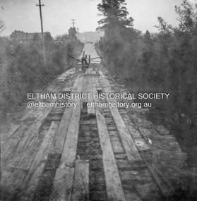
Album - Photograph, J.A. McDonald, Eltham-Greensborough Road, 18 Oct. 1956
... Bridge Street Bridge Flood level on Eltham pier 18th... melbourne Bridge Street Bridge Flood level on Eltham pier 18th ...Bridge Street Bridge Flood level on Eltham pier 18th October 1956 Looking west across the Diamond Creek to Susan Street intersection Beware!.. our rivers are rising (1956, October 19). The Argus (Melbourne, Vic. : 1848 - 1957), p. 1. Retrieved August 24, 2022, from http://nla.gov.au/nla.news-article84392304Record of various Shire of Eltham infrastructure works undertaken during the period of 1952-1962 involving bridge and road reconstruction projects, sometimes with Eltham Shire Council Project Reference numbers quoted. It was during this period that a number of significant improvements were made to roads and new bridges constructed within the shire that remain in place as of present day (2022). In many situations, the photos provide a tangible visible record of infrastructure that existed throughout the early days of the Shire. The album was put together by or under the direction of the Shire Engineer, J.A. McDonald.infrastructure, road construction, shire of eltham, bridge construction, bridge street bridge, eltham, eltham-greensborough road, 1956-10-18, diamond creek (creek), floods, floodwater, silver street bridge -
 Eltham District Historical Society Inc
Album - Photograph, J.A. McDonald, Eltham-Greensborough Road, June 1956
... Diamond Creek Bridge (Bridge Street Bridge) Deck being... melbourne Diamond Creek Bridge (Bridge Street Bridge) Deck being ...Diamond Creek Bridge (Bridge Street Bridge) Deck being stripped June 1956 View looking southeast from the western bank of the Diamond Creek close to the present-day Eltham Skatepark. On the far centre left can be seen the Eltham Methodist Church on the cirner of John Street and Main Road, now the Eltham-Montmorency Uniting ChurchRecord of various Shire of Eltham infrastructure works undertaken during the period of 1952-1962 involving bridge and road reconstruction projects, sometimes with Eltham Shire Council Project Reference numbers quoted. It was during this period that a number of significant improvements were made to roads and new bridges constructed within the shire that remain in place as of present day (2022). In many situations, the photos provide a tangible visible record of infrastructure that existed throughout the early days of the Shire. The album was put together by or under the direction of the Shire Engineer, J.A. McDonald.infrastructure, road construction, shire of eltham, bridge construction, 1956-06, bridge street bridge, eltham, eltham-greensborough road, methodist church, presbyterian church, uniting church