Showing 270 items
matching dangerous
-
 Eltham District Historical Society Inc
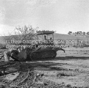
Negative - Photograph, J.A. McDonald, Kangaroo Ground-Queenstown Road, Aug. 1960
(Kangaroo Ground-St Andrews Road) “Rymers” Corner – shifting Hawthorn hedges on Tompkins property Council’s Drott 6 Woods Drott 9 August 1960 Showing hedge in rear already transported EDHS_05569-55 (EDHS_05577-3/4) and EDHS_05569-56 (EDHS_05577-5/6) - Hawthorn Hedges, Kangaroo Ground 50-50 ELTHAM, CUT THE HEDGES! While all of us are talking about the road toll, Eltham Council must have been in long recess. Around Kangaroo Ground are farmers’ hawthorn hedges shrouding dangerous corners on busy roads. If the council does not insist on their removal for a distance clear enough for safe driving, then it must be held culpable for the accidents that are bound to happen. – WAKE UP (Melbourne) ELTHAM, CUT THE HEDGES! 50-50 (1960, 6 January), The Sun (News clipping held in SEA_74-1_007) ‘BAD HEDGES’ WILL GO “We know there are some bad hedges on corners in the Kangaroo Ground area, but roadworks this year will eliminate them,” the Eltham Shire secretary, Mr Maxwell B. Watson, said yesterday. A reader in 50-50 yesterday complained of farmers’ hawthorn hedges obscuring drivers’ views at bad corners on busy roads in the Kangaroo Ground district. Mr Watson said the roadworks were deviations to remove the sharp turns, and the road would cut back into paddocks. The hedges would go at the same time. Meanwhile, the shire had power to require owners to cut back hedges, and this would be done if specific instances were reported and found justifiable. ‘BAD HEDGES’ WILL GO (1960, January 7), The Sun (News clipping held in SEA_74-1_007)Record of various Shire of Eltham infrastructure works undertaken during the period of 1952-1962 involving bridge and road reconstruction projects, sometimes with Eltham Shire Council Project Reference numbers quoted. It was during this period that a number of significant improvements were made to roads and new bridges constructed within the shire that remain in place as of present day (2022). In many situations, the photos provide a tangible visible record of infrastructure that existed throughout the early days of the Shire. The album was put together by or under the direction of the Shire Engineer, J.A. McDonald.infrastructure, shire of eltham, 1960-08, garden hill, kangaroo ground, kangaroo ground-queenstown road, kangaroo ground-st andrews road, rymers corner, bulldozer, drott -
 Eltham District Historical Society Inc
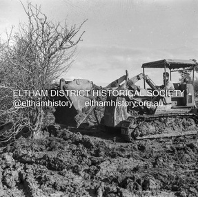
Negative - Photograph, J.A. McDonald, Kangaroo Ground-Queenstown Road, Aug. 1960
(Kangaroo Ground-St Andrews Road) “Rymers” Corner – shifting Hawthorn hedges on Tompkins property Council’s Drott 6 Woods Drott 9 August 1960 Showing method of lifting clumps of Hawthorn EDHS_05569-55 (EDHS_05577-3/4) and EDHS_05569-56 (EDHS_05577-5/6) - Hawthorn Hedges, Kangaroo Ground 50-50 ELTHAM, CUT THE HEDGES! While all of us are talking about the road toll, Eltham Council must have been in long recess. Around Kangaroo Ground are farmers’ hawthorn hedges shrouding dangerous corners on busy roads. If the council does not insist on their removal for a distance clear enough for safe driving, then it must be held culpable for the accidents that are bound to happen. – WAKE UP (Melbourne) ELTHAM, CUT THE HEDGES! 50-50 (1960, 6 January), The Sun (News clipping held in SEA_74-1_007) ‘BAD HEDGES’ WILL GO “We know there are some bad hedges on corners in the Kangaroo Ground area, but roadworks this year will eliminate them,” the Eltham Shire secretary, Mr Maxwell B. Watson, said yesterday. A reader in 50-50 yesterday complained of farmers’ hawthorn hedges obscuring drivers’ views at bad corners on busy roads in the Kangaroo Ground district. Mr Watson said the roadworks were deviations to remove the sharp turns, and the road would cut back into paddocks. The hedges would go at the same time. Meanwhile, the shire had power to require owners to cut back hedges, and this would be done if specific instances were reported and found justifiable. ‘BAD HEDGES’ WILL GO (1960, January 7), The Sun (News clipping held in SEA_74-1_007)Record of various Shire of Eltham infrastructure works undertaken during the period of 1952-1962 involving bridge and road reconstruction projects, sometimes with Eltham Shire Council Project Reference numbers quoted. It was during this period that a number of significant improvements were made to roads and new bridges constructed within the shire that remain in place as of present day (2022). In many situations, the photos provide a tangible visible record of infrastructure that existed throughout the early days of the Shire. The album was put together by or under the direction of the Shire Engineer, J.A. McDonald.infrastructure, shire of eltham, 1960-08, garden hill, kangaroo ground, kangaroo ground-queenstown road, kangaroo ground-st andrews road, rymers corner, bulldozer, drott -
 Eltham District Historical Society Inc
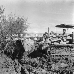
Negative - Photograph, J.A. McDonald, Kangaroo Ground-Queenstown Road, Aug. 1960
(Kangaroo Ground-St Andrews Road) “Rymers” Corner – shifting Hawthorn hedges on Tompkins property Council’s Drott 6 Woods Drott 9 August 1960 Showing method of lifting clumps of Hawthorn EDHS_05569-55 (EDHS_05577-3/4) and EDHS_05569-56 (EDHS_05577-5/6) - Hawthorn Hedges, Kangaroo Ground 50-50 ELTHAM, CUT THE HEDGES! While all of us are talking about the road toll, Eltham Council must have been in long recess. Around Kangaroo Ground are farmers’ hawthorn hedges shrouding dangerous corners on busy roads. If the council does not insist on their removal for a distance clear enough for safe driving, then it must be held culpable for the accidents that are bound to happen. – WAKE UP (Melbourne) ELTHAM, CUT THE HEDGES! 50-50 (1960, 6 January), The Sun (News clipping held in SEA_74-1_007) ‘BAD HEDGES’ WILL GO “We know there are some bad hedges on corners in the Kangaroo Ground area, but roadworks this year will eliminate them,” the Eltham Shire secretary, Mr Maxwell B. Watson, said yesterday. A reader in 50-50 yesterday complained of farmers’ hawthorn hedges obscuring drivers’ views at bad corners on busy roads in the Kangaroo Ground district. Mr Watson said the roadworks were deviations to remove the sharp turns, and the road would cut back into paddocks. The hedges would go at the same time. Meanwhile, the shire had power to require owners to cut back hedges, and this would be done if specific instances were reported and found justifiable. ‘BAD HEDGES’ WILL GO (1960, January 7), The Sun (News clipping held in SEA_74-1_007)Record of various Shire of Eltham infrastructure works undertaken during the period of 1952-1962 involving bridge and road reconstruction projects, sometimes with Eltham Shire Council Project Reference numbers quoted. It was during this period that a number of significant improvements were made to roads and new bridges constructed within the shire that remain in place as of present day (2022). In many situations, the photos provide a tangible visible record of infrastructure that existed throughout the early days of the Shire. The album was put together by or under the direction of the Shire Engineer, J.A. McDonald.infrastructure, shire of eltham, 1960-08, garden hill, kangaroo ground, kangaroo ground-queenstown road, kangaroo ground-st andrews road, rymers corner, bulldozer, drott -
 Eltham District Historical Society Inc
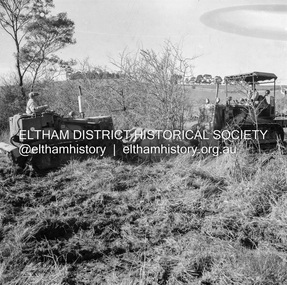
Negative - Photograph, J.A. McDonald, Kangaroo Ground-Queenstown Road, Aug. 1960
(Kangaroo Ground-St Andrews Road) “Rymers” Corner – shifting Hawthorn hedges on Tompkins property Council’s Drott 6 Woods Drott 9 August 1960 EDHS_05569-55 (EDHS_05577-3/4) and EDHS_05569-56 (EDHS_05577-5/6) - Hawthorn Hedges, Kangaroo Ground 50-50 ELTHAM, CUT THE HEDGES! While all of us are talking about the road toll, Eltham Council must have been in long recess. Around Kangaroo Ground are farmers’ hawthorn hedges shrouding dangerous corners on busy roads. If the council does not insist on their removal for a distance clear enough for safe driving, then it must be held culpable for the accidents that are bound to happen. – WAKE UP (Melbourne) ELTHAM, CUT THE HEDGES! 50-50 (1960, 6 January), The Sun (News clipping held in SEA_74-1_007) ‘BAD HEDGES’ WILL GO “We know there are some bad hedges on corners in the Kangaroo Ground area, but roadworks this year will eliminate them,” the Eltham Shire secretary, Mr Maxwell B. Watson, said yesterday. A reader in 50-50 yesterday complained of farmers’ hawthorn hedges obscuring drivers’ views at bad corners on busy roads in the Kangaroo Ground district. Mr Watson said the roadworks were deviations to remove the sharp turns, and the road would cut back into paddocks. The hedges would go at the same time. Meanwhile, the shire had power to require owners to cut back hedges, and this would be done if specific instances were reported and found justifiable. ‘BAD HEDGES’ WILL GO (1960, January 7), The Sun (News clipping held in SEA_74-1_007)Record of various Shire of Eltham infrastructure works undertaken during the period of 1952-1962 involving bridge and road reconstruction projects, sometimes with Eltham Shire Council Project Reference numbers quoted. It was during this period that a number of significant improvements were made to roads and new bridges constructed within the shire that remain in place as of present day (2022). In many situations, the photos provide a tangible visible record of infrastructure that existed throughout the early days of the Shire. The album was put together by or under the direction of the Shire Engineer, J.A. McDonald.infrastructure, shire of eltham, 1960-08, garden hill, kangaroo ground, kangaroo ground-queenstown road, kangaroo ground-st andrews road, rymers corner, bulldozer, drott -
 Department of Energy, Environment and Climate Action
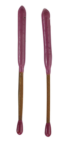
Delayed Action Incendiary Device (DAID)
The Forests Commission developed the use of helicopters for aerial ignition from the mid 1960s. Bryant and May at Richmond worked with the Commission to develop a Delayed Action Incendiary Device. DAIDs as the were known, had an overall length of 180 mm, striker end length - 10 mm. Ignition end length - 80 mm, then a layer of high melting point wax (to prevent accidental ignition when rubbing together in transit). Both ends coated with a modified match head compound with safety fuse exposed length between coated match ends. There was a 17-second delay from when the small end was struck to an intense flaming of the large end, which lasted for 40 seconds. DAIDs were dangerous so were stored in a metal box outside the helicopter along with a disposable striker patch attached with a quick release pin to a special half-door. The first test was with a Bell 47G on 4 October 1967 and the first use, anywhere in the world, of DAIDs to backburn a large bushfire was undertaken in north eastern Victoria in February 1968. There was a crash of an FCV helicopter conducting aerial ignition near Wandiligong on 19 April 1978 with the tragic death of two forest officers and their pilot. The crash led to the immediate end of the use of DAIDs and the adoption of the safer Premo ping-pong ball incendiary machine which originally came from Canada but was modified at the Altona workshops. Overall, the development of aerial ignition techniques by the Forests Commission from the mid-1960s resulted in a steady climb in the area burnt each year…. peaking at 477,000 ha in 1980-81 and with an impressive 10-year rolling average of 220,000 ha around the time of 1983 Ash Wednesday Bushfires.Developed in Victoria for aerial ignition by the FCV and Byant & MayLarge double ended match used for aerial ignition and back burning by dropping from a helicopterforests commission victoria (fcv), bushfire, planned burning -
 Federation University Historical Collection
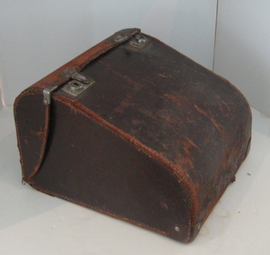
Calculator, Burroughs, Calculator (Adding Machine), c1935
The "Burroughs Calculator" was a non-printing key-driven machine introduced in 1912 in response to the success of the Felt & Tarrant "Comptometer". The first Burroughs key-driven machine was very similar to the Comptometer in its external appearance, but was quite different in its internal mechanism, with the register and carry mechanism based on a complex system of planetary gears. It was only about two-thirds of the weight of the Felt & Tarrant machine, and had none of the safety features. In particular, there was no protection against incomplete keystrokes in either direction. The register would simply advance in proportion to the depth of stroke, with no indication of error. However, the price was also about two-thirds of the Comptometer, which made it quite a popular (if dangerous) machine. (http://home.vicnet.net.au/~wolff/calculators/Burroughs/Burroughs.htm) The Burroughs Portable Adding Machine introduced in 1925 became the basic design for the adding machine for many years, until the ten key adder was introduced and started to replace it gradually. The key-driven type machine did not print, and while it was often used as an adding machine, it developed into a special purpose machine in later years. The machine was very fast . The efficient operation of these machines required an experienced operator who often received a high salary. The machine was produced over a very long period because of its unique capabilities and was often used to verify product delivery lists from delivery routes. Later models of the machine, called a duplex design, could hold a running total in a second set of dial wheels while the primary wheels continued to add and subtotal amounts that could be transferred at any time to the running total. A side note, Burroughs copied the Felt design for its first models and was sued for patent infringement by Felt and Tarrant who prevailed in the suit. As a result, Burroughs totally redesigned their machine and went on to compete with the Felt machine for decades. Info from (http://www.burroughsinfo.com/group_d.htm) Black metal low keyboard manual adding machine. The key-driven type machine did not print, and was exceedingly fast and experienced operators could easily outrun an operator on a full keyboard or 10-key adding machine. The adding machine has a brown leather carry case.calculator -
 Mission to Seafarers Victoria
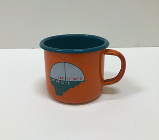
Souvenir - Cup, Margaret Woodward, 2015
Margaret Woodward is a an artist and an an associate professor of design at Charles Sturt University. Artist statement: "The Sea is All Around us is a multi-layered event which creates a memorable experience for those visiting the Dome Gallery and the Mission to Seafarers in Melbourne’s Docklands. The event acknowledges and raises awareness of the often difficult and dangerous working lives and journeys of seafarers by making visible their role in transporting commodities, materials and objects to and from Australia’s shores. This installation at the Dome Gallery in the Mission to Seafarers in Melbourne’s Docklands marks the third stage of an ongoing research project which seeks to reveal the ‘social life’ of souvenirs. Beyond their representational role souvenirs also trigger intangible, affective qualities – reminders of journeys and places, new associations with tastes, sounds and people, and thereby becoming objects which focus and hold memories. This installation invites seafarers and visitors to participate in a global project which aims to witness sea journeys and trace the mobile life of seafarers and souvenirs. For a fortnight in May 2015, the Dome Gallery became an architectural large scale compass, with the circular floor marking the intersection of its latitude and longitude (37 º 49'21" S 144º 57'03"E). Over these two weeks the Dome Gallery was inscribed with marks recording journeys made by seafarers, recording destination and departure ports, home lands and waterways, and in doing so making visible a small segment of the global patterns of seafaring. Custom-made souvenirs designed for the installation are given to seafarers as gestures of welcome and a memento of their visit. The souvenirs originating in Poland continue their journey by sea, to destinations beyond the Dome becoming part of the global network of seafaring, with an invitation for seafarers to record their future journeys using QR code scanning technologies. It is hoped that by releasing the 200 limited edition souvenirs accompanying the seafarers the mobile life of souvenirs and seafarers will also become visible. Like messages in bottles they leave our shores, becoming ambassadors, representing the Dome Gallery at the Mission to Seafarers, the waters of Port Phillip Bay, Australia’s red soil and vegetation, and carrying memories of visiting Melbourne." The Mission has always been open to the community and has a tradition of hosting cultural events: shows, concerts, exhibitions, festivals.Orange enamel and teal mug created for the art installation by artist Margaret Woodward at the Mission to Seafarers. On one side it is decorated with a compass and a latitude and longitude; on the opposite side, a leaf, a QR code on the bottom takes you to the website.Written at the bottom of the mug: Please scan to map the journey of this souvenir * www.sensingtheremote.net *2015cultural events, norla dome, mso, 2015, art installation, margaret woodward -
 Mission to Seafarers Victoria
Booklet - Catalogue, Margaret Woodward, The Sea is All Around us, 2015
Margaret Woodward is a an artist and an an associate professor of design at Charles Sturt University. Artist statement: "The Sea is All Around us is a multi-layered event which creates a memorable experience for those visiting the Dome Gallery and the Mission to Seafarers in Melbourne’s Docklands. The event acknowledges and raises awareness of the often difficult and dangerous working lives and journeys of seafarers by making visible their role in transporting commodities, materials and objects to and from Australia’s shores. This installation at the Dome Gallery in the Mission to Seafarers in Melbourne’s Docklands marks the third stage of an ongoing research project which seeks to reveal the ‘social life’ of souvenirs. Beyond their representational role souvenirs also trigger intangible, affective qualities – reminders of journeys and places, new associations with tastes, sounds and people, and thereby becoming objects which focus and hold memories. This installation invites seafarers and visitors to participate in a global project which aims to witness sea journeys and trace the mobile life of seafarers and souvenirs. For a fortnight in May 2015, the Dome Gallery became an architectural large scale compass, with the circular floor marking the intersection of its latitude and longitude (37 º 49'21" S 144º 57'03"E). Over these two weeks the Dome Gallery was inscribed with marks recording journeys made by seafarers, recording destination and departure ports, home lands and waterways, and in doing so making visible a small segment of the global patterns of seafaring. Custom-made souvenirs designed for the installation are given to seafarers as gestures of welcome and a memento of their visit. The souvenirs originating in Poland continue their journey by sea, to destinations beyond the Dome becoming part of the global network of seafaring, with an invitation for seafarers to record their future journeys using QR code scanning technologies. It is hoped that by releasing the 200 limited edition souvenirs accompanying the seafarers the mobile life of souvenirs and seafarers will also become visible. Like messages in bottles they leave our shores, becoming ambassadors, representing the Dome Gallery at the Mission to Seafarers, the waters of Port Phillip Bay, Australia’s red soil and vegetation, and carrying memories of visiting Melbourne." The Mission has always been open to the community and has a tradition of hosting cultural events: shows, concerts, exhibitions, festivals.Small flyer in PDf for the art installation by artist Margaret Woodward at the Mission to Seafarerscultural events, norla dome, mso, 2015, art installation, margaret woodward -
 Flagstaff Hill Maritime Museum and Village
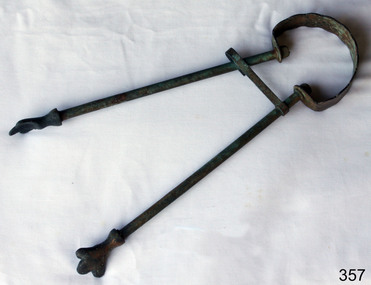
Domestic object - Fire Tongs
Fireplace tongs were used to add wood to the fireplace as well as break down the crackling wood to add more oxygen to growing flames. Of the four tools that were usually found in an upright fireplace set, tongs had the biggest design variation. Some tongs looked like medical calipers that were rounded at the bottom, while others were almost like metronomes with their rectangular shapes. https://www.lovetoknow.com/home/antiques-collectibles/vintage-antique-fireplace-tools Tongs are tools used to handle items, and generally move the item from one place to another, or turn things, like a piece of meat on a barbecue. Tongs usually have flat ends to pick up items without damaging them and to grip onto the items easily, however, some tongs have claws or toothed ends to grab more bulky and slippery items. Tongs are used mainly for handling food or hot items. Modern tongs are usually made from plastic, metal, stainless steel, or other material, depending on their purpose. Originally, tongs were probably wood sticks that eventually became metal sticks around 3000 BC to handle hot items in a fire Tongs are used to extend the hand or as a replacement handler for potentially dangerous items. Tongs usually have a sprung end so that the operator is required to squeeze the middle of the tongs to grab hold of an item, or they have a pivot which requires the user to squeeze the handles at the end to grip onto items, these being more effective at holding heavy items due to the extra force able to be applied. There are many types of tongs including barbecue tongs, salad tongs, blacksmith tongs, crucible tongs, ice cube tongs, sugar cube tongs and fire tongs. Tongs are often called ‘a pair of tongs’ and the word comes from the Old English, ‘tange’ or ‘tang’, meaning ‘that which bites’. There is evidence of Egyptians using metal rods and tong like tools to hold objects over fire, in around 1450 BC. https://tenrandomfacts.com/tongs/Fire tongs are still used with most open fires in homes.Brass fire tongs with holding clip and flat rounded handle at the end.None.flagstaff hill, warrnambool, shipwrecked-coast, flagstaff-hill, flagstaff-hill-maritime-museum, maritime-museum, shipwreck-coast, flagstaff-hill-maritime-village, fireplace tools, tongs -
 Ballarat Tramway Museum
Book, State Electricity Commission of Victoria (SECV), "Electric Tramways of the State Electricity Commission of Victoria - By-Law No. 1 - August, 1965", Aug. 1965
1297 - Booklet with red heavy card cover and 24 pages inside and a four page supplement glued into rear cover giving details of the by-laws operating for the SEC tramways in Ballarat and Bendigo. Gives details of the definitions, fares and charges, sale of tickets, regulating number of passengers, stopping places, nuisances, smoking, dangerous goods, luggage and goods, general matters and fares broken into adult fares for each section and Children's fares and Pensioners' Concession fares for both Ballarat and Bendigo. Note - introduced decimal currency into the fares as well as pence. Document number on front cover "TYE 1-270". This by-law replaced or revoked all previous by-laws and amendments. Came in effect 1/10/1965 with a fare rise. Received Governor In Council approval on 24/8/1965. These fares have been amended in pencil for Ballarat. The amendment pasted into the rear of the booklet is dated 2nd August. 1966 and came into effect on 1/9/1966. 1297.1 - ditto, but actual used copy by D. J. Everett - see Reg. Item 2292 for details of SEC Ballarat Employee. On page one or title sheet, has an additional amendment pasted in - dated 14/1/1969 giving details of fare increases in Ballarat and Bendigo to come into effect 14/1/1969. Single sheet printed both side. See also Reg items 66 and 281 for this sheet of paper by itself. Item added 2/3/2003. 1297.2 - booklet as above for 1297, but without supplements - in as printed condition 8/1965. 1297.3 - as for 1297 with 1966 and two number 1969 supplements pasted into the book. One 1969 supplement at the front and additional at the rear. 1966 supplement pasted into the rear of the book. Has BTPS Catalogue Numbers 207, 208 and 209 written onto the front of the booklet. Four other copies - unnumbered held. Additional items added 10/7/2005. Additional copy of 1297.3 added 6/8/2016 from donation of T. Jeffreys. 1297 - In pencil on pages 15 to 18 showing revised fares and the number "58 676" on page 24 - possibly a telephone number. 1297.3 - has "Ballarat Tramway Preservation Society Catalogue Nos. 207, 208, 209" written in black ink on the top of the cover.trams, tramways, secv rules, by laws, tickets, fares, ballarat, bendigo -
 Parks Victoria - Wilsons Promontory Lightstation
Stretcher
Made of canvas and bamboo slats with hemp ropes, adjustable canvas straps and metal buckles and rings, the rescue stretcher was used for carrying an injured person. According to the Powerhouse Museum, the stretcher and was ‘designed to support and carry an injured person in circumstances where the person has to be lifted vertically’. Known as the ‘Neil Robertson stretcher’, it was developed in the early 1900s by John Neil Robertson as a lightweight rescue device and was modelled on Japanese bamboo litters. An identical stretcher is held in Sydney’s Powerhouse Museum and is thought to date between c.1967 and 1999. The museum’s statement of significance for the unique stretcher elaborates on its cultural values: The canvas is wrapped around the patient and secured with strong canvas straps. A lifting rope is attached to a ring above the patient's head, while a guideline is tied near the ankles and used to stop the stretcher swaying as it is hoisted up. This style of stretcher was specifically designed for use on ships, where casualties might have to be lifted from engine-room spaces, holds and other compartments with access hatches too small for ordinary stretchers. The original name of the Neil Robertson stretcher was 'Hammock for hoisting wounded men from stokeholds and for use in ships whose ash hoists are 2 ft. 6 in. diameter'. Since those times the Neil Robertson stretcher has also been used in factories and mines and for other emergency rescue situations. It is still possible to buy this type of stretcher although the slats are now more likely to be made of wood. The example in the Powerhouse collection was amongst several items of obsolete first aid and rescue equipment donated by the electricity generation company Delta Electricity. It would have been used - or at least been on stand-by - at the company's Munmorah Power Station or the associated coal mine on the Central Coast of New South Wales. Industrial sites and mines are extremely dangerous work places. Throughout the 20th century to the present there has been a drive, especially in developed countries like Australia, to improve workplace safety. Measures taken to reduce injuries and deaths have included safer industrial equipment, safer work practices, staff training, and the ready availability of accident and emergency equipment.It was also used throughout WWI and WWII. There are two other examples of the stretcher are known in Parks Victoria heritage collections. Canvas and bamboo stretcher with straps and buckles. Hemp ropes are attached to the stretcher. -
 Melbourne Tram Museum
Photograph - Last day of original Essendon Airport tram terminus, Ron Scholten, 7-10-1976
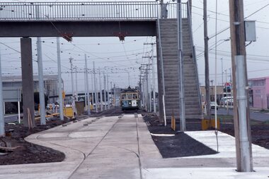
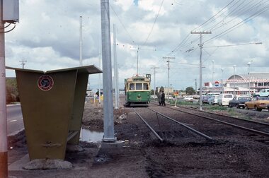
The original line to the Essendon Aerodrome was constructed in 1943 to serve the airport and aircraft construction. It was funded by the Commonwealth Government. By 1976, patronage to the airport terminus in Vaughan St had dropped, the crossing of the highway to the Tullamarine Airport opened in 1970, was dangerous, and the highway needed to be widened. The new terminus was a short distance to the north between Mathews Ave and the Highway. This series of photographs show the last day of operations to the original terminus and the changeover, which was done in about 7 hours. No buses were required. It was done by workers of the Melbourne and Metropolitan Tramways Board. The line was later extended to Airport West. .1 - W5 789, (Essendon Airport Route 59) about to turn from Mathews Ave into Vaughan St. Has new track and footbridge in the foreground. .2 - W5 791 on the siding or spur at the airport terminus, the last tram to use this facility. .3 - W2 571, at the Airport terminus alongside Vaughan St on the last morning of the use of this terminus. The Bundy clock can be seen behind the pole on the lefthand side and the Brick passenger shelter. Shows buffer stops, and Forestair hanger behind. .4 - W2 595 turning from Vaughan St into Mathews Ave. Has the tram stop No. 55 in the view. .5 - W5 839 turning from Vaughan St into Mathews Ave. Shows the flashing yellow light that gave some protection to the trams. .6 - W2 247 about to turn into Vaughan St. Driver about to reboard the tram. Note the new copper trolley wire is up for the new track but has been pulled to the west side using rope. .7 - W5 805, turning from Mathews Ave into Vaughan St, to the old Essendon Airport terminus. Has a new track in the foreground, and the overhead for the curves is still in position. .8 - W6 991 turning from Vaughan St into Matthews Ave, at 855am, the last tram from the old terminus. The track gang has commenced work to remove the outbound curve. Would appear four passengers waiting at the tram stop, two with lunch bags. Note the cattle grid in the foreground between the rails. New rails on the ground on the left-hand side. See Reg Item 6163 for further photos of this event.Yields information about the last day of the operation of the original Essendon Airport tram line.Set of 8 Kodachrome cardboard mount colour slides of the relocation of the Essendon Airport tram terminus 7-10-1976, by Ron Scholten.All slides have detailed descriptions on the reartrams, tramways, essendon aerodrome, essendon airport, closure, new tramways, route 59, w5 789, w5 791, w2 571, w2 595, w5 839, w2 247, w5 805, w6 991, w2 class, w5 class, w6 class, mmtb, trackwork -
 Melbourne Tram Museum
Photograph - Changing the Location of the Essendon Airport terminus, Ron Scholten, 7-10-1976
The original line to the Essendon Aerodrome was constructed in 1943 to serve the airport and aircraft construction. It was funded by the Commonwealth Government. By 1976, patronage to the airport terminus in Vaughan St had dropped, the crossing of the highway to the Tullamarine Airport opened in 1970, was dangerous, and the highway needed to be widened. The new terminus was a short distance to the north between Mathews Ave and the Highway. This series of photographs show the operation of a tram service during the changeover. Trams ran from the Niddrie crossover near Keilor Road to a temporary terminus just short of the worksite, with cars running "bang" road or the wrong way for one trip along either line. This would have been controlled by an Inspector at the Niddrie end. The work was done over a 7-hour period, including changing the overhead over. Work would have been completed after the changeover period. .1 - W5 800 at “temporary” Essendon Airport terminus, Cnr Mathews Ave, Vaughan St. after running “bang” road or the wrong way to this point from the Niddrie or Keilor Road crossover. Curves have been removed.. Has an Inspector chatting to a man with a hat standing alongside the tram. The shelter has a City of Keilor logo on it. .2 - W5 684, taken from the overbridge at the TAA stop - during the changeover of the tracks. Tram running “bang” road from Niddrie to the temporary terminus. .3 - SW5 787, temporary terminus in Mathews Ave, about to return to Niddrie as an “up” car on the “down” line. .4 - MMTB Track gang commissioning and placing rails at the new terminus with scrubber 10 waiting. Overhead in position with overhead for the curves partly removed. Mobile Crane on the left-hand side moving a formwork piece into position .5 - 10W cleaning new track at the new terminus. .6 - Rail Scrubber 10W at work cleaning head of rails where new concrete section. Has a TAA bus on the right side. .7 - W5 783 is about to be the first passenger tram to the terminus, at 3.50 pm About 20 workmen are completing the inbound or up track. .8 - W5 783 about to be the first passenger tram to the terminus, at 3.50 pm About 20 workmen are completing the inbound or up track.Yields information about the last day of the operation of the original Essendon Airport tram line and the works done for the new terminus.Set of 8 Kodachrome cardboard mount colour slides of the relocation of the Essendon Airport tram terminus 7-10-1976, by Ron Scholten. All slides have detailed descriptions on the rear trams, tramways, essendon aerodrome, essendon airport, closure, new tramways, route 59, mmtb, trackwork, w5 800, w5 684, sw5 787, scrubber 10w, w5 783, w5 class, sw5 class, taa airlines, city of keilor -
 Flagstaff Hill Maritime Museum and Village
Functional object - Copper Sheet, circa 1878
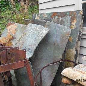
In 1984 the Commonwealth Government made available to Flagstaff Hill a collection of lead ingots and copper sheets recovered from the wreck-site of the LOCH ARD. They were presented to the Warrnambool City Council by the Hon. Tom Uren MHR, Minister for Territories and Local Government: “The Commonwealth recognises that shipwrecks like the LOCH ARD are our national heritage with important educational, recreational and tourist applications” (The Standard, Tuesday 8 May 1984). The LOCH ARD was wrecked in 1878. Unsuccessful salvage operations were then undertaken with the 90 ton paddle steamer NAPIER. In sudden bad weather this vessel too was sunk. The precise position of the LOCH ARD in the exposed and dangerous waters off Mutton Bird Island became lost to memory. The underwater location of the LOCH ARD was rediscovered in 1967 by a Warrnambool skindiver, Stan McPhee. In the two years following his find, the vessel was systematically pillaged by unauthorised salvagers. This led to the State and Federal Governments’ intervention in 1969. A roundup and seizure of recovered lead ingots and copper sheets was conducted by Commonwealth and Victorian Police. Offenders were charged and convicted. The “repossessed loot of the Tassie Boys” was placed into secure storage (Jack Loney, 1978, Wrecks & Reputations). The LOCH ARD manifest of cargo lists “Pig lead 50 tons, 994 pig & 37 rolls” and “Copper 33 plates, 53 bolts”. While the lead ingots have been subsequently described as “ballast”, the copper sheets are unlikely to have been associated with the ship’s normal complement in that way. Similar product lines in the cargo manifest are “Bar and rod iron 102 tons”, “Plate iron 3 tons” and “Zinc 12 tons”. These raw materials were used by colonial artisans such as blacksmiths and metal smelters to fashion, and repair, agricultural implements and industrial machinery. Copper was valued for its non-corrosive properties and its malleability, or ease of working. Both these qualities were useful, for example, in laying underground gas pipes that supplied lighting to residences, businesses and streetscapes in the mid-nineteenth century. As the nineteenth century progressed, the metal was also increasingly valued for its conductivity, with copper wiring linking colonial communities to each other, and the wider world, via the Telegraph system. The average weight of the copper sheets is 216 kilograms, calculated by "volume 0.1936m³ X Cu density 8930kgs/m³".The shipwreck of the Loch Ard is of significance for Victoria and is registered on the Victorian Heritage Register ( S 417). Flagstaff Hill has a varied collection of artefacts from Loch Ard and its collection is significant for being one of the largest accumulation of artefacts from this notable Victorian shipwreck. The collections object is to also give us a snapshot into history so we can interpret the story of this tragic event. The collection is also archaeologically significant as it represents aspects of Victoria's shipping history that allows us to interpret Victoria's social and historical themes of the time. The collections historically significance is that it is associated unfortunately with the worst and best-known shipwreck in Victoria's history. Large heavy sheets or panels of copper metal raised from the wreck of the LOCH ARD. The 10 sheets are of roughly similar dimensions and rectangular shape. They bear signs of prolonged submersion in seawater, with various degrees of limestone accretion, adhered marine growth, and green oxidisation. Three of the sheets are severely buckled, demonstrating the force of underwater explosives used in their salvage. One sheet appears cut or severed in a diagonal line downwards from its top left hand corner. One sheet has a 10cm X 10cm square cut out of its top right hand corner. All sheets are in sturdy, stable condition. No maker’s marks are visible.flagstaff hill, warrnambool, shipwrecked coast, flagstaff hill maritime museum, flagstaff hill maritime village, great ocean road, loch line, loch ard, captain gibbs, eva carmichael, tom pearce, glenample station, mutton bird island, loch ard gorge, sailing ship, copper sheet, manutacturing materials, metal imports, muntz -
 Flagstaff Hill Maritime Museum and Village
Badge - Gripman Badge, Stokes & Sons, Jul 1916 - Nov. 1919
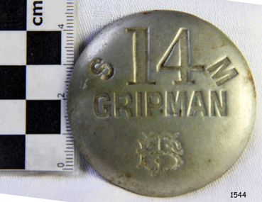
This cable tram Gripman’s badge, or driver’s badge, was part of a tram driver’s uniform. The inscriptions on the front of the badge identify it as belonging to Gripman number 14, at the South Melbourne Car House depot of the Tramways Board. The Gripman Badge would be re-issued whenever another Gripman takes over the position. Cable trams were invented in America in 1873. In Melbourne, cable trams were in use from 1885 until 1940, with a network of up to 1200 cable cars or 'dummies' and trailers travelling at around 9.5 miles (15km) per hour along 46 miles (74km) of double tracks. The Gripman drove the dummy car, operating the heavy levers to connect the gripping gears to the cable installed in a slot in the road. To turn at intersections he would skilfully disconnect, freewheel around the corner and carefully reconnect to the continuously operating steel cable. Large winding gears in an Engine House along the line pulled the cable along, powered by steam engines and later electric engines. The gripping gears were in the centre of the car's floor with seating all around the sides, a dangerous place for curious children. , whose worried parents would guide them into the tram that was towed behind the dummy car. The Melbourne Tramways Board operated the cable trams between July 1916 and November 1919 after taking over from the privately operated Melbourne Tramway and Omnibus Company. In 1919, the Melbourne and Metropolitan Tramways Board (MMTB) took over the Tramways Board. Stokes & Sons: - The maker of the badge, Thomas Stokes, migrated to Melbourne from Birmingham in 1854 and set up business in Mincer Lane as a die-sinker, producing medals, tokens, buttons and silverware, and an engraving service. He moved to Flinders Lane in 1856. After a time, in 1894, the business became Stokes & Sons Pty: Ltd, electroplates and badge makers at Post Office Place in Melbourne. The maker's mark 'Stokes & Sons' was made on badges until 1962. LOCAL CONNECTION: -t was common practice to recycle the used cables from the tramway. For example, the Wollaston Bridge in Warrnambool, Victoria, is suspended by recycled cable tram Melbourne. (Other recycled cables were used for fencing wire.) -Portland's cable tram is an example of the cable trams used in Melbourne from 1885 to 1940.This badge was used to identify a Gripman who operated a cable car tram's dummy car for the Tramways Board in Melbourne between 1916 and 1919. It represents the need for people to be able to identify workers in the service industry, a need still addressed today by staff ID badges and digital identification. The badge also represents the period in Melbourne's history when cable cars were used for public transport for over four decades, gradually changing from steam to electric power. Trams still have an important role in Melbourne's public transport. Badge, round hollow metal dome with two open metal guides on the back. A cable tram Gripman (driver) badge with embossed inscriptions on the front and stamped on the back. There is a logo of entwined letters T and B on the front. It identifies Gripman number 14, South Melbourne, Tramway Board. It was made by Stokes & Sons of Melbourne. Impressed into the front: "S / 14 / M" "GRIPMAN" Logo intertwined "T" and "B" Embossed on reverse "STOKES &o SONS"flagstaff hill, flagstaff hill maritime museum and village, warrnambool, maritime museum, maritime village, great ocean road, shipwreck coast, badge, gripman, stokes & sons, numesmatics, tramway, tram, tram driver, uniform, cable tram, identification, cable car driver, tramway board, south melbourne, melbourne tramways board, tb, mtb, mmtb, melbourne and metropolitan tramways board, tramway button, gripman button, id, identification badg, staff badge, name badge, employee, grip car, dummy car -
 Melbourne Tram Museum
Book, Agatha Christie, "Destination unknown", 1954
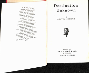
Book, hard cover, 12 sections, sewn with end papers, 210 pages, titled "Destination unknown", written by Agatha Christie, published by The Crime Club, 1954. Has the stamp of the Footscray Tramway Library, asking it to be returned within 14 days inside the front cover and in many places throughout the book, along with Number "606" on the inside front cover and on the spine of the book. The book was part of a library run by the depot staff to provide materials during broken shifts and to take home. From Wikipedia - accessed 26/12/2019: Plot summary Hilary Craven, a deserted wife and bereaved mother, is planning suicide in a Moroccan hotel, when she is asked by British secret agent Jessop to undertake a dangerous mission as an alternative to taking an overdose of sleeping pills. The task, which she accepts, is to impersonate the wife of Thomas Betterton, a nuclear scientist who has disappeared and may have defected to the Soviet Union. Soon she finds herself in a group of oddly-assorted travellers being transported to the unknown destination of the title. The destination turns out to be a secret scientific research facility disguised as a modern leper colony and medical research center at a remote location in the Atlas Mountains. The scientists are well-treated, but they are not allowed to leave the facility, and they are locked in secret areas deep inside the mountain whenever government officials and other outsiders visit. Hilary Craven successfully passes herself as Betterton's wife Olive, because he is miserable and wants desperately to escape. Hilary discovers that the facility was built by the fabulously wealthy and somewhat villainous Mr Aristides, for financial rather than political ends. He has lured the world's best young scientists to it with various deceptions so that he can later sell their services back to the world's governments and corporations for a huge profit. She falls in love with Andrew Peters, a handsome young American who was in the group with her on their journey to the facility. With the help of clues she has left along the way, Jessop eventually locates and rescues her and the others held there. Peters turns out also to be on a mission, intent on bringing Betterton to justice for the murder of his first wife. Betterton, revealed to also be a scientific fraud who plagiarized his work, is arrested. Hilary no longer wants to die, and she and Peters are free to begin their life together.On the top of the first page "13/3" indicating the price, "m/arz"? on the bottom left hand corner and inside the front cover the label of "Robertson & Mullens Ltd" booksellers.trams, tramways, footscray depot, libraries, novels, personnel, crews, shifts -
 The Beechworth Burke Museum
Photograph, 1907-8
The photo from 1907-8 is a sepia print, depicting a small valley with building at base. There are flumes visible above areas of water, trees on hills and a few small cottages on the hillside. Cock's Pioneer Gold & Tin Sluicing Co NZ No 2 Site. The photo was taken of Matthews Gully looking west. Sluicing was undertaken in the area from 1900 to 1942 with some short breaks between these periods. The image depicts a location mined by Cocks Pioneer Gold and Tin Sluicing Company (as recorded on the annotation on the card mount) The Cocks Pioneer Gold and Tin Mines N.L was one of El Dorado's two largest open cut sluicing mines of the 20th Century. The other was named the Cocks El Dorado Gold Dredging Company. The Cocks Pioneer Mines operated from 1901 until 1941 and found a total of 117,378 ounces of Gold and 1,673 tones of tin concentrates over these years. The Cocks company was formed in 1898 and operated until 1941. Open cut sluicing involved the use of high-powered hoses which used the centrifugal sand pump system (known as hydraulic sluicing) which broke down the soil which was then processed for gold and other precious metals. From 1914 , four years after this image was captured, the company reformed to Cocks Pioneer Gold and Tin Mines NL (previously it was known as Cocks Pioneer Sluicing Co) and undertook large scale sluicing operations until 1929 and then 1934-1941. El Dorado is located on Reedy Creek and is surrounded by forested country to the north and east. It is 20 km east of Wangaratta in Victoria's regional north-east. John Cock was the son of a Cornish minor who arrived in El Dorado in 1858. Cock founded his gold and tin mining company which ran successfully for many years in the El Dorado region. It was an open cut sluicing company because of the abandonment of underground mining after this was deemed too dangerous. In 1935 Cock's El Dorado Company commissioned the floating dredge which is still visible in El Dorado today. The dredge was built by the Thompson engineering works, Castlemaine, and weighed over 2,000 tones and today has a place on the Victorian Registers of historic buildings. Interestingly, the name El Dorado does not derive from the gold in the region, but from the Barambogie pastoral run completed by William Baker in 1840-1841. Gold was discovered in El Dorado 1854 but the gold was too deep for individual prospectors to find, it required the use of heavy machinery.The search for gold is ingrained into the history of Victoria and therefore, images like this one which portray an open cut sluicing site can reveal important information for society and technology for the date when the photograph was taken. This image is of important historical significance for its ability to convey information about sluicing and the methods used to find gold in 1910. It also shows a location where sluicing was undertook which provides insight into the impact of sluicing on the environment at a time when it was done. This image is important for current research into the history of El Dorado, a small regional location near Wangaratta in Victoria's North East. Therefore, this image has the capacity to be beneficial for research into society and the motivations of those living and working in this region during this period and therefore, has social significance. The Beechworth Burke Museum has additional images relating to gold sluicing and El Dorado which can be analysed and studied alongside images like this one.Sepia coloured rectangle photograph printed on gloss photographic paper Reverse: 1997. 2613/ A02613/ No2 site/ Matthews Gully/ Cocks Pioneer G&T. ?? Co NZ/ No2 Site looking West/ 1907-8/ (7)sluicing, hydraulic sluicing, 1907, 1908, mining, cock's pioneer gold & tin sluicing co nz, nz, site no 2, matthews gully, west, valley, building, cottages, hillside, trees, water, gold and tin mine -
 Eltham District Historical Society Inc
Photograph, View looking up 'Policeman's Hill' on Main Road from Dalton Street showing Police Residence, c.1906, 2010c
For original image see EDHS_00533 This photo was originally mounted on 3mm MDF fibre board with notes and stickers applied as part of a display on the former Police Residence and now present day Local History Centre, home to Eltham District Historical Society; possibly put together by Harry Gilham during his time as president of the society. Eltham Police Station and Residence: A brief history 1860 Eltham Courthouse built in Main Road, together with an adjoining police residence, office, lock–up and stables. 1959 Police Department purchases a house in Pryor Street to be refurbished as Eltham Police Station 1961 Police in Eltham move into Pryor Street refurbished buildings and office. c.1961-1981 Occupied by Vermin and Noxious Weeds Destruction Section of the Department of Crown Lands and Survey. Former Police Station dragged around to rear of Police Residence (prior to August 1967) to make way for the construction of a driveway and access from Main Road. The building was placed on the site of a former Scullery and modified for Lands Department use. 1981 Shire of Eltham take over management of old Police Residence in Eltham. It remains unoccupied for a period of time whilst its future is discussed in Council. 1981-1985 Used for community job creation scheme 1985 Shire of Eltham Parks and Environment occupy the residence. Council improve the driveway but later add a second rear access from Brougham Street due to the dangerous nature of the Main Road entrance. Also add a rear toilet facility between the Police Residence and former Police Station, which was doubling up as a lunch room. Council also commence discussions to re-establish a replica Police Station. c.1986 November. Former Police Station demolished; believed to have been suffering termite damage. c.1989 After some years of discussion a replica Police Station is built, based on photographs, to act as a lunch room and meeting room for Parks and Environment staff and volunteers doing community service. 1996 Eltham District Historical Society in discussions with Nillumbik Shire Council commisioners throughout the year regarding a home for the Society. A proposal put forward by the Society in October to occupy the former Police Residence. 1997 March. Eltham District Historical Society gains access to former Police Residence. 1998 July 12th. Eltham District Historical Society Inc moves into its Local History Centre, 728 Main Road Eltham (the former Police Residnce built in 1860). 2018 July. Eltham District Historical Society gains access to the replica Police Station for use as part of regular heritage tours for schools and community based groups.Black and white photocopyLabels and handwriting in pencil and ink identifying various buildings. Also highlighted is the acetylene gas lamp and on reverse is written "Lamplighter Jimm Saville"728 main road, eltham, local history centre, parks and environment, police residence, police station, shire of eltham -
 Royal Australian and New Zealand College of Obstetricians & Gynaecologists (RANZCOG)
Equipment - Medical case used by Dr Reginald Worcester
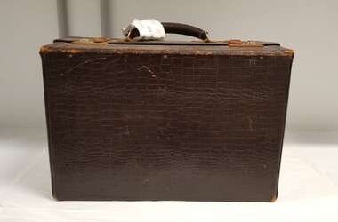
Reginald George Worcester (1903-1972) was a highly regarded obstetrics and gynaecology specialist. Between 1930 and 1933, Worcester was the Medical Superintendent at the Royal Women's Hospital. He obtained his MRCOG in England in 1935, and on his return to Australia was appointed as a university tutor in obstetrics and gynaecology. In 1939, he was appointed as the honorary gynaecologist to outpatients at the Royal Women's Hospital. Worcester served with the AIF during World War II as C.O. of the 17th Field Ambulance in Darwin and as A.D.M.S., Northern Territory Force, and the 2nd/9th Australian Army Corps from 1942 to 1943. His major war service, however, was undertaken in Borneo and Moratai, commanding the 2nd/1st Australian C.C.S. and the 2nd/9th Australian General Hospital. Worcester acquitted himself admirably during the war, with company commander Hubert Smith praising his contribution in no uncertain terms: " His [Worcester's] success as C.O. of a Field Ambulance resulted from a complete understanding of what the unit should be able to do in the transportation of casualties in the field, as well as of the usual medial functions. He organized both with efficiency and at all times difficult decisions were made with humility and good humour. The personal qualities which made him such a calm and considerate consultant never left him, even in the most dangerous and trying circumstances of war." Worcester's time in the army greatly affected his health, but despite this he was able to build a strong and reputable practice upon his return to Australia. As outlined by Arthur Hill, Worcester " was appointed in turn to the following important posts: Honorary Outpatient Obstetrician and Inpatient Gynaecologist to the Women’s Hospital (1946-1948); Honorary Gynaecologist to Prince Henry’s Hospital (1946-1963); Guest Examiner in London for the R.C.O.G. (1953); Examiner in Obstetrics and Gynaecology for the Royal Australasian College of Surgeons (1957-1964); Visiting Gynaecologist to the Repatriation General Hospital, Heidelberg 1963- 1967); and first Victorian Members’ representative (1947-1950) and later Fellows’ Representative (1953-1960) on the Australian (Regional) Council of the R.C.O.G. To these posts he brought the benefits of clear thinking and critical awareness. In 1949 he was elected F.R.C.O.G." In early 1967, Worcester suffered a hemiplegia which left him with an impaired gait and paralysed his right hand. Although unable to do major surgery, he returned to part-time practice by September 1967. His ill-health persisted though, and he was retired from practice in 1970. (Source: (1973), REGINALD GEORGE WORCESTER. Medical Journal of Australia, 1: 770-771.)Brown leather medical case. The case has a solid frame and is rectangular, with a leather handle at top. There are two locks on the top of the case, and a metal clasp on either side to fasten the bag closed. The case is embossed with the text 'R.G. WORCESTER' on top, in a position between the two locks and below the handle at bottom centre. The inside of the case is lined with a canvas bag that is buttoned to the case with press studs. The inside of the case also contains a loose canvas bag on which is handwritten 'BAG No/THREE/ R.G. WORCESTER'. The loose canvas bag has a metal zipper at opening.'R.G.WORCESTER'obstetrics, surgery -
 The Beechworth Burke Museum
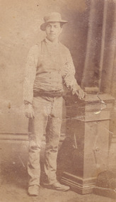
Photograph - Carte de Visite, James Bray, 1870
This photograph was taken in c.1870 and depicts Aaron Sherrtt who is best known for his involvements with, and eventual assassination by, the Kelly gang. He stands upright in the image with his arm leaning on a podium which reaches his hip. He is wearing an outfit for which he was infamous. Richard Warren, son of the proprietor of the Ovens and Murray Advertiser once stated that “anyone seeing [Aaron] coming down Ford Street would ask, “Who the hell’s this? Some advance agent for the circus?”’. The outfit Aaron wore for this particular photoshoot is reminiscent of this quote. He wears an unusual spotted shirt with a waistcoat and a sash is tied at his waist. He wears boots which turn up slightly at the toes. The hat is a “pork pie” hat which is worn in the typical “Greta Mob” style with the chinstrap under the nose. Aaron Sherritt was born in 1854 in Prahran, Melbourne, to Irish Protestant parents John and Anne. Sherritt stood at 5 foot 10. He had hazel eyes, dark brown hair and pale olive skin. Sherritt was childhood friends with Kelly Gang member, Joe Byrne, having previously attended the same school. Both men had a reputation for stealing horses and on one occasion, after stealing and butchering a cow, Sherritt and Byrne were convicted to six months in Beechworth Gaol (1876). Sherritt, along with Byrne, were reportedly recruited by Ned Kelly in 1877 in stealing stock; however, Sherritt never became a fully-fledged member of the Kelly Gang. Nevertheless, Sherritt scouted for the Kelly Gang in 1878. He later struck a deal with the police (specifically, with Chief Commissioner Standish) to save Joe Byrne's life in exchange for leading the police to the other members of the Gang. From then on, Aaron Sherritt lived the dangerous life of a double agent, providing police with what is assumed today to have been outdated or incorrect information in return for money. On the 26th of June 1880, Aaron Sherritt was murdered in the Woolshed Valley. He was approximately 23-25 years old at death. This event marked the start of the Kelly gang’s last days. Sherritt was murdered by Byrne in front of his wife, 15 year old and heavily pregnant Ellen “Belle” Sherritt and her mother Ellen Barry. Also in the Sherritt dwelling on this particular night were four policemen. The intention behind Sherritt’s murder was for the police to send word to Melbourne that the Kelly gang had murdered Sherritt and a police train would be sent to Glenrowan where the rest of the Kelly gang were waiting. This plan did not go as predicted and ultimately the Kelly gang fell at Glenrowan in 1880. This photograph was taken by James Bray who worked as a professional photographer in Camp Street Beechworth from 1870-1891. He was one of four men who photographed the Kelly Gang after the siege in Glenrowan in 1880. He is also renowned for his previous work photographing members of the Kelly gang. This photograph is part of the Burke Museum "Kelly album" which includes a significant collection of photographs and artefacts connected to Ned Kelly and the Kelly Gang. Ned Kelly and his gang have become ingrained in Australian popular culture and thus many museums, art galleries and private collections house material connected to the Kelly story which allows the events and people to be researched and interpreted. Artefacts and photographs pertaining to the Kelly gang are particularly valuable for Australian museums. This particular photograph is significant for its connection to Beechworth photographer James Bray who is responsible for many images depicting members of the Kelly Gang. The photograph is also of artistic significance as an example of a Carte de Viste dating to 1880 and it's connection to Aaron Sherritt.Sepia rectangular photograph printed on card. Obverse: J.E.Bray./ Photo/ Beechworth Reverse: Portrait & Landscape/ Photographer 5/ Aaron Sherritt J E Bray Signature Beechworth/ Victoria Beware (almost erased out) Negatives Kept. Copies 5I/.Each May/ Be Had By Forwarding Name And Address/ Accompanied With Remittance To/ The Amount Of Order/ Photographs Coloured In Water Colours 10237. kelly album, woolshed valley, 1870s, kelly gang, joe byrne, ned kelly, aaron sherritt, james bray, beechworth, burke museum -
 The Beechworth Burke Museum
Photograph, 1910 - 1911
This photograph depicts Cock's Pioneer G & T Sluicing site No. 4 in El Dorado. Looking eastwards, the photo captures a wooden and tin building with various mining equipment strewn in the foreground. Underneath the verandah, figures can be seen. These are believed to be a Mr. Hollister (left), Mrs. Breustedt (4th from left), children Min and Chris Breustedt, and Kate Timmons holding a girl's hand. The Cocks Pioneer Gold and Tin Mines N.L was one of El Dorado's two largest open-cut sluicing mines of the 20th Century. The other was named the Cocks El Dorado Gold Dredging Company. The Cocks Pioneer Mines operated from 1901 until 1941 and found a total of 117,378 ounces of Gold and 1,673 tones of tin concentrates over these years. The Cocks company was formed in 1898 and operated until 1941. Open cut sluicing involved the use of high-powered hoses which used the centrifugal sand pump system (known as hydraulic sluicing) which broke down the soil which was then processed for gold and other precious metals. From 1914, four years after this image was captured, the company reformed to Cocks Pioneer Gold and Tin Mines NL (previously it was known as Cocks Pioneer Sluicing Co) and undertook large-scale sluicing operations until 1929 and then 1934-1941. The Cocks Pioneer was an extremely successful mining company during the 20th century. In the Annual Report of the Secretary for Mines for the year 1915, the Cocks Pioneer was the largest producer of gold and tin collecting 5,535 ozs. of gold and £7,500 of tin. Twenty years later in 1935, Cocks Pioneer was still one of the most profitable mines in Victoria, ranking as the second-highest dividend paying mine. The company produced a total of 3,650 kg of gold. El Dorado is located on Reedy Creek and is surrounded by forested country to the north and east. It is 20 km east of Wangaratta in Victoria's regional northeast. John Cock was the son of a Cornish miner who arrived in El Dorado in 1858. Cock founded his gold and tin mining company which ran successfully for many years in the El Dorado region. It was an open-cut sluicing company because of the abandonment of underground mining after this was deemed too dangerous. In 1935 Cock's El Dorado Company commissioned the floating dredge which is still visible in El Dorado today. The dredge was built by the Thompson engineering works, Castlemaine, and weighed over 2,000 tones and today has a place on the Victorian Registers of historic buildings. Interestingly, the name El Dorado does not derive from the gold in the region, but from the Barambogie pastoral run completed by William Baker in 1840-1841. Gold was discovered in El Dorado in 1854 but the gold was too deep for individual prospectors to find, it required the use of heavy machinery.The search for gold is ingrained into the history of Victoria and therefore, images like this one which portray an open cut sluicing site can reveal important information for society and technology for the date when the photograph was taken. This image is of important historical significance for its ability to convey information about sluicing and the methods used to find gold in 1910. It also shows a location where sluicing was undertook which provides insight into the impact of sluicing on the environment at a time when it was done. This image is important for current research into the history of El Dorado, a small regional location near Wangaratta in Victoria's North East. Therefore, this image has the capacity to be beneficial for research into society and the motivations of those living and working in this region during this period and therefore, has social significance. The Beechworth Burke Museum has additional images relating to gold sluicing and El Dorado which can be analysed and studied alongside images like this one.A black and white copy of a sepia coloured rectangular photograph printed on matte photographic paper mounted on boardObverse: COCKS PIONEER G + T SL CO, N.L. / 1910 - 11 / NO 4 SITE LOOKING EAST / 4 Reverse: 1997.2508 / AUG 29 1909cocks pioneer gold and tin sluicing company, el dorado, mining, sluicing, hydraulic mining, hollister, breustedt, timmons, gold, tin, gold rush, victoria -
 The Beechworth Burke Museum
Photograph, 1910
This photograph dating to 1910 depicts an open cut sluicing site located in El Dorado captured looking east up the open cut from the number 3 Barge site. Sluicing was undertaken in the area from 1900 to 1942 with some short breaks between these periods. The image depicts a location mined by Cocks Pioneer Gold and Tin Sluicing Company (as recorded on the annotation on the card mount). It portrays open cut rocks with a crevice in the center of the image where the sluicing was being undertaken. There is a small timber structure on the right of the image which could be an entrance to a mine or supports made of wood to prevent a cave in at the open cut site and above the cut rock there is bush. The timber structure has rail tracks on top of the bridge which could suggest the identification of this structure as a mine entrance. The rail tracks were used for little carts which hauled soil from the mine. The Cocks Pioneer Gold and Tin Mines N.L was one of El Dorado's two largest open cut sluicing mines of the 20th Century. The other was named the Cocks El Dorado Gold Dredging Company. The Cocks Pioneer Mines operated from 1901 until 1941 and found a total of 117,378 ounces of Gold and 1,673 tones of tin concentrates over these years. The Cocks company was formed in 1898 and operated until 1941. Open cut sluicing involved the use of high-powered hoses which used the centrifugal sand pump system (known as hydraulic sluicing) which broke down the soil which was then processed for gold and other precious metals. From 1914 , four years after this image was captured, the company reformed to Cocks Pioneer Gold and Tin Mines NL (previously it was known as Cocks Pioneer Sluicing Co) and undertook large scale sluicing operations until 1929 and then 1934-1941. El Dorado is located on Reedy Creek and is surrounded by forested country to the north and east. It is 20 km east of Wangaratta in Victoria's regional north-east. John Cock was the son of a Cornish minor who arrived in El Dorado in 1858. Cock founded his gold and tin mining company which ran successfully for many years in the El Dorado region. It was an open cut sluicing company because of the abandonment of underground mining after this was deemed too dangerous. In 1935 Cock's El Dorado Company commissioned the floating dredge which is still visible in El Dorado today. The dredge was built by the Thompson engineering works, Castlemaine, and weighed over 2,000 tones and today has a place on the Victorian Registers of historic buildings. Interestingly, the name El Dorado does not derive from the gold in the region, but from the Barambogie pastoral run completed by William Baker in 1840-1841. Gold was discovered in El Dorado 1854 but the gold was too deep for individual prospectors to find, it required the use of heavy machinery.The search for gold is ingrained into the history of Victoria and therefore, images like this one which portray an open cut sluicing site can reveal important information for society and technology for the date when the photograph was taken. This image is of important historical significance for its ability to convey information about sluicing and the methods used to find gold in 1910. It also shows a location where sluicing was undertook which provides insight into the impact of sluicing on the environment at a time when it was done. This image is important for current research into the history of El Dorado, a small regional location near Wangaratta in Victoria's North East. Therefore, this image has the capacity to be beneficial for research into society and the motivations of those living and working in this region during this period and therefore, has social significance. The Beechworth Burke Museum has additional images relating to gold sluicing and El Dorado which can be analysed and studied alongside images like this one.Sepia coloured rectangular photograph printed on gloss photographic paper mounted on board.Obverse: COCKS PIONEER Q + T SL CO, N.L. / 1910 / LOOKING EAST UP OPEN CUT / FROM NO3 BARGE SITE / Reverse: 1997 . 2611 / A02611el dorado, north east gold, sluicing, gold sluicing, hydraulic sluicing, 1910, gold and tin mine, open cut mining, mining, gold mining, north-east victoria, beechworth, burke museum -
 Eltham District Historical Society Inc
Photograph, Former Eltham Police Residence, 728 Main Road, Eltham, c.1985, 1985c
This photo is believed to have been taken circa 1985 when the Shire of Eltham Parks and Environment occupied the site. This photo was originally mounted on 3mm MDF fibre board with notes and stickers applied as part of a display on the former Police Residence and now present day Local History Centre, home to Eltham District Historical Society; possibly put together by Harry Gilham during his time as president of the society. Eltham Police Station and Residence: A brief history 1860 Eltham Courthouse built in Main Road, together with an adjoining police residence, office, lock–up and stables. 1959 Police Department purchases a house in Pryor Street to be refurbished as Eltham Police Station 1961 Police in Eltham move into Pryor Street refurbished buildings and office. c.1961-1981 Occupied by Vermin and Noxious Weeds Destruction Section of the Department of Crown Lands and Survey. Former Police Station dragged around to rear of Police Residence (prior to August 1967) to make way for the construction of a driveway and access from Main Road. The building was placed on the site of a former Scullery and modified for Lands Department use. 1981 Shire of Eltham take over management of old Police Residence in Eltham. It remains unoccupied for a period of time whilst its future is discussed in Council. 1981-1985 Used for community job creation scheme 1985 Shire of Eltham Parks and Environment occupy the residence. Council improve the driveway but later add a second rear access from Brougham Street due to the dangerous nature of the Main Road entrance. Also add a rear toilet facility between the Police Residence and former Police Station, which was doubling up as a lunch room. Council also commence discussions to re-establish a replica Police Station. c.1986 November. Former Police Station demolished; believed to have been suffering termite damage. c.1989 After some years of discussion a replica Police Station is built, based on photographs, to act as a lunch room and meeting room for Parks and Environment staff and volunteers doing community service. 1996 Eltham District Historical Society in discussions with Nillumbik Shire Council commisioners throughout the year regarding a home for the Society. A proposal put forward by the Society in October to occupy the former Police Residence. 1997 March. Eltham District Historical Society gains access to former Police Residence. 1998 July 12th. Eltham District Historical Society Inc moves into its Local History Centre, 728 Main Road Eltham (the former Police Residnce built in 1860). 2018 July. Eltham District Historical Society gains access to the replica Police Station for use as part of regular heritage tours for schools and community based groups.Colour printHandwritten in faded blue felt pen ink "No. 3 - Front of 728 Police Residence. 1860 Court House over the paling fence. Verandah missing from earlier photographs"728 main road, eltham, local history centre, parks and environment, police residence, police station, shire of eltham -
 Eltham District Historical Society Inc
Photograph, Former Eltham Police Residence, 728 Main Road, Eltham, c.1985, 1985c
This photo is believed to have been taken circa 1985 when the Shire of Eltham Parks and Environment occupied the site. This photo was originally mounted on 3mm MDF fibre board with notes and stickers applied as part of a display on the former Police Residence and now present day Local History Centre, home to Eltham District Historical Society; possibly put together by Harry Gilham during his time as president of the society. Eltham Police Station and Residence: A brief history 1860 Eltham Courthouse built in Main Road, together with an adjoining police residence, office, lock–up and stables. 1959 Police Department purchases a house in Pryor Street to be refurbished as Eltham Police Station 1961 Police in Eltham move into Pryor Street refurbished buildings and office. c.1961-1981 Occupied by Vermin and Noxious Weeds Destruction Section of the Department of Crown Lands and Survey. Former Police Station dragged around to rear of Police Residence (prior to August 1967) to make way for the construction of a driveway and access from Main Road. The building was placed on the site of a former Scullery and modified for Lands Department use. 1981 Shire of Eltham take over management of old Police Residence in Eltham. It remains unoccupied for a period of time whilst its future is discussed in Council. 1981-1985 Used for community job creation scheme 1985 Shire of Eltham Parks and Environment occupy the residence. Council improve the driveway but later add a second rear access from Brougham Street due to the dangerous nature of the Main Road entrance. Also add a rear toilet facility between the Police Residence and former Police Station, which was doubling up as a lunch room. Council also commence discussions to re-establish a replica Police Station. c.1986 November. Former Police Station demolished; believed to have been suffering termite damage. c.1989 After some years of discussion a replica Police Station is built, based on photographs, to act as a lunch room and meeting room for Parks and Environment staff and volunteers doing community service. 1996 Eltham District Historical Society in discussions with Nillumbik Shire Council commisioners throughout the year regarding a home for the Society. A proposal put forward by the Society in October to occupy the former Police Residence. 1997 March. Eltham District Historical Society gains access to former Police Residence. 1998 July 12th. Eltham District Historical Society Inc moves into its Local History Centre, 728 Main Road Eltham (the former Police Residnce built in 1860). 2018 July. Eltham District Historical Society gains access to the replica Police Station for use as part of regular heritage tours for schools and community based groups.Colour printHandwritten in faded blue felt pen ink "No. 2 - Backyard of 728 #5 Weatherboard 'Office'. Note 1860 Court House over the fence."728 main road, eltham, local history centre, parks and environment, police residence, police station, shire of eltham -
 Eltham District Historical Society Inc
Photograph, Former Eltham Police Residence, 728 Main Road, Eltham, c.1985, 1985c
This photo is believed to have been taken circa 1985 when the Shire of Eltham Parks and Environment occupied the site. This photo was originally mounted on 3mm MDF fibre board with notes and stickers applied as part of a display on the former Police Residence and now present day Local History Centre, home to Eltham District Historical Society; possibly put together by Harry Gilham during his time as president of the society. Eltham Police Station and Residence: A brief history 1860 Eltham Courthouse built in Main Road, together with an adjoining police residence, office, lock–up and stables. 1959 Police Department purchases a house in Pryor Street to be refurbished as Eltham Police Station 1961 Police in Eltham move into Pryor Street refurbished buildings and office. c.1961-1981 Occupied by Vermin and Noxious Weeds Destruction Section of the Department of Crown Lands and Survey. Former Police Station dragged around to rear of Police Residence (prior to August 1967) to make way for the construction of a driveway and access from Main Road. The building was placed on the site of a former Scullery and modified for Lands Department use. 1981 Shire of Eltham take over management of old Police Residence in Eltham. It remains unoccupied for a period of time whilst its future is discussed in Council. 1981-1985 Used for community job creation scheme 1985 Shire of Eltham Parks and Environment occupy the residence. Council improve the driveway but later add a second rear access from Brougham Street due to the dangerous nature of the Main Road entrance. Also add a rear toilet facility between the Police Residence and former Police Station, which was doubling up as a lunch room. Council also commence discussions to re-establish a replica Police Station. c.1986 November. Former Police Station demolished; believed to have been suffering termite damage. c.1989 After some years of discussion a replica Police Station is built, based on photographs, to act as a lunch room and meeting room for Parks and Environment staff and volunteers doing community service. 1996 Eltham District Historical Society in discussions with Nillumbik Shire Council commisioners throughout the year regarding a home for the Society. A proposal put forward by the Society in October to occupy the former Police Residence. 1997 March. Eltham District Historical Society gains access to former Police Residence. 1998 July 12th. Eltham District Historical Society Inc moves into its Local History Centre, 728 Main Road Eltham (the former Police Residnce built in 1860). 2018 July. Eltham District Historical Society gains access to the replica Police Station for use as part of regular heritage tours for schools and community based groups.Colour printHandwritten in faded blue felt pen ink "Roof of room 5 (weatherboard office) and W.C. See No. 2 for another view"728 main road, eltham, local history centre, parks and environment, police residence, police station, shire of eltham -
 Eltham District Historical Society Inc
Photograph, Former Eltham Police Residence, 728 Main Road, Eltham, c.1985, 1985c
This photo is believed to have been taken circa 1985 when the Shire of Eltham Parks and Environment occupied the site. This photo was originally mounted on 3mm MDF fibre board with notes and stickers applied as part of a display on the former Police Residence and now present day Local History Centre, home to Eltham District Historical Society; possibly put together by Harry Gilham during his time as president of the society. Eltham Police Station and Residence: A brief history 1860 Eltham Courthouse built in Main Road, together with an adjoining police residence, office, lock–up and stables. 1959 Police Department purchases a house in Pryor Street to be refurbished as Eltham Police Station 1961 Police in Eltham move into Pryor Street refurbished buildings and office. c.1961-1981 Occupied by Vermin and Noxious Weeds Destruction Section of the Department of Crown Lands and Survey. Former Police Station dragged around to rear of Police Residence (prior to August 1967) to make way for the construction of a driveway and access from Main Road. The building was placed on the site of a former Scullery and modified for Lands Department use. 1981 Shire of Eltham take over management of old Police Residence in Eltham. It remains unoccupied for a period of time whilst its future is discussed in Council. 1981-1985 Used for community job creation scheme 1985 Shire of Eltham Parks and Environment occupy the residence. Council improve the driveway but later add a second rear access from Brougham Street due to the dangerous nature of the Main Road entrance. Also add a rear toilet facility between the Police Residence and former Police Station, which was doubling up as a lunch room. Council also commence discussions to re-establish a replica Police Station. c.1986 November. Former Police Station demolished; believed to have been suffering termite damage. c.1989 After some years of discussion a replica Police Station is built, based on photographs, to act as a lunch room and meeting room for Parks and Environment staff and volunteers doing community service. 1996 Eltham District Historical Society in discussions with Nillumbik Shire Council commisioners throughout the year regarding a home for the Society. A proposal put forward by the Society in October to occupy the former Police Residence. 1997 March. Eltham District Historical Society gains access to former Police Residence. 1998 July 12th. Eltham District Historical Society Inc moves into its Local History Centre, 728 Main Road Eltham (the former Police Residnce built in 1860). 2018 July. Eltham District Historical Society gains access to the replica Police Station for use as part of regular heritage tours for schools and community based groups.Colour printHandwritten in faded blue felt pen ink "Another view of north wall 728 No. 4. Taken from west end towards back yard"728 main road, eltham, local history centre, parks and environment, police residence, police station, shire of eltham -
 Eltham District Historical Society Inc
Photograph, Former Eltham Police Residence, 728 Main Road, Eltham, c.1985, 1985c
This photo is believed to have been taken circa 1985 when the Shire of Eltham Parks and Environment occupied the site. This photo was originally mounted on 3mm MDF fibre board with notes and stickers applied as part of a display on the former Police Residence and now present day Local History Centre, home to Eltham District Historical Society; possibly put together by Harry Gilham during his time as president of the society. Eltham Police Station and Residence: A brief history 1860 Eltham Courthouse built in Main Road, together with an adjoining police residence, office, lock–up and stables. 1959 Police Department purchases a house in Pryor Street to be refurbished as Eltham Police Station 1961 Police in Eltham move into Pryor Street refurbished buildings and office. c.1961-1981 Occupied by Vermin and Noxious Weeds Destruction Section of the Department of Crown Lands and Survey. Former Police Station dragged around to rear of Police Residence (prior to August 1967) to make way for the construction of a driveway and access from Main Road. The building was placed on the site of a former Scullery and modified for Lands Department use. 1981 Shire of Eltham take over management of old Police Residence in Eltham. It remains unoccupied for a period of time whilst its future is discussed in Council. 1981-1985 Used for community job creation scheme 1985 Shire of Eltham Parks and Environment occupy the residence. Council improve the driveway but later add a second rear access from Brougham Street due to the dangerous nature of the Main Road entrance. Also add a rear toilet facility between the Police Residence and former Police Station, which was doubling up as a lunch room. Council also commence discussions to re-establish a replica Police Station. c.1986 November. Former Police Station demolished; believed to have been suffering termite damage. c.1989 After some years of discussion a replica Police Station is built, based on photographs, to act as a lunch room and meeting room for Parks and Environment staff and volunteers doing community service. 1996 Eltham District Historical Society in discussions with Nillumbik Shire Council commisioners throughout the year regarding a home for the Society. A proposal put forward by the Society in October to occupy the former Police Residence. 1997 March. Eltham District Historical Society gains access to former Police Residence. 1998 July 12th. Eltham District Historical Society Inc moves into its Local History Centre, 728 Main Road Eltham (the former Police Residnce built in 1860). 2018 July. Eltham District Historical Society gains access to the replica Police Station for use as part of regular heritage tours for schools and community based groups.Colour printHandwritten in faded blue felt pen ink "Repeat view of No. 4 from external corner of weatherboard extn. Room 5"728 main road, eltham, local history centre, parks and environment, police residence, police station, shire of eltham -
 Eltham District Historical Society Inc
Photograph, Former Eltham Police Residence, 728 Main Road, Eltham, c.1985, 1985c
This photo is believed to have been taken circa 1985 when the Shire of Eltham Parks and Environment occupied the site. This photo was originally mounted on 3mm MDF fibre board with notes and stickers applied as part of a display on the former Police Residence and now present day Local History Centre, home to Eltham District Historical Society; possibly put together by Harry Gilham during his time as president of the society. Eltham Police Station and Residence: A brief history 1860 Eltham Courthouse built in Main Road, together with an adjoining police residence, office, lock–up and stables. 1959 Police Department purchases a house in Pryor Street to be refurbished as Eltham Police Station 1961 Police in Eltham move into Pryor Street refurbished buildings and office. c.1961-1981 Occupied by Vermin and Noxious Weeds Destruction Section of the Department of Crown Lands and Survey. Former Police Station dragged around to rear of Police Residence (prior to August 1967) to make way for the construction of a driveway and access from Main Road. The building was placed on the site of a former Scullery and modified for Lands Department use. 1981 Shire of Eltham take over management of old Police Residence in Eltham. It remains unoccupied for a period of time whilst its future is discussed in Council. 1981-1985 Used for community job creation scheme 1985 Shire of Eltham Parks and Environment occupy the residence. Council improve the driveway but later add a second rear access from Brougham Street due to the dangerous nature of the Main Road entrance. Also add a rear toilet facility between the Police Residence and former Police Station, which was doubling up as a lunch room. Council also commence discussions to re-establish a replica Police Station. c.1986 November. Former Police Station demolished; believed to have been suffering termite damage. c.1989 After some years of discussion a replica Police Station is built, based on photographs, to act as a lunch room and meeting room for Parks and Environment staff and volunteers doing community service. 1996 Eltham District Historical Society in discussions with Nillumbik Shire Council commisioners throughout the year regarding a home for the Society. A proposal put forward by the Society in October to occupy the former Police Residence. 1997 March. Eltham District Historical Society gains access to former Police Residence. 1998 July 12th. Eltham District Historical Society Inc moves into its Local History Centre, 728 Main Road Eltham (the former Police Residnce built in 1860). 2018 July. Eltham District Historical Society gains access to the replica Police Station for use as part of regular heritage tours for schools and community based groups.Colour printHandwritten in faded blue felt pen ink "Backdoor to residence. White paint still visible 2010 on brickwork"728 main road, eltham, local history centre, parks and environment, police residence, police station, shire of eltham -
 Eltham District Historical Society Inc
Photograph, Former Eltham Police Residence, 728 Main Road, Eltham, c.1985, 1985c
This photo is believed to have been taken circa 1985 when the Shire of Eltham Parks and Environment occupied the site. This photo was originally mounted on 3mm MDF fibre board with notes and stickers applied as part of a display on the former Police Residence and now present day Local History Centre, home to Eltham District Historical Society; possibly put together by Harry Gilham during his time as president of the society. Eltham Police Station and Residence: A brief history 1860 Eltham Courthouse built in Main Road, together with an adjoining police residence, office, lock–up and stables. 1959 Police Department purchases a house in Pryor Street to be refurbished as Eltham Police Station 1961 Police in Eltham move into Pryor Street refurbished buildings and office. c.1961-1981 Occupied by Vermin and Noxious Weeds Destruction Section of the Department of Crown Lands and Survey. Former Police Station dragged around to rear of Police Residence (prior to August 1967) to make way for the construction of a driveway and access from Main Road. The building was placed on the site of a former Scullery and modified for Lands Department use. 1981 Shire of Eltham take over management of old Police Residence in Eltham. It remains unoccupied for a period of time whilst its future is discussed in Council. 1981-1985 Used for community job creation scheme 1985 Shire of Eltham Parks and Environment occupy the residence. Council improve the driveway but later add a second rear access from Brougham Street due to the dangerous nature of the Main Road entrance. Also add a rear toilet facility between the Police Residence and former Police Station, which was doubling up as a lunch room. Council also commence discussions to re-establish a replica Police Station. c.1986 November. Former Police Station demolished; believed to have been suffering termite damage. c.1989 After some years of discussion a replica Police Station is built, based on photographs, to act as a lunch room and meeting room for Parks and Environment staff and volunteers doing community service. 1996 Eltham District Historical Society in discussions with Nillumbik Shire Council commisioners throughout the year regarding a home for the Society. A proposal put forward by the Society in October to occupy the former Police Residence. 1997 March. Eltham District Historical Society gains access to former Police Residence. 1998 July 12th. Eltham District Historical Society Inc moves into its Local History Centre, 728 Main Road Eltham (the former Police Residnce built in 1860). 2018 July. Eltham District Historical Society gains access to the replica Police Station for use as part of regular heritage tours for schools and community based groups.Colour printHandwritten in faded blue felt pen ink "No. 1 South wall of 728 & back of house built 1860 [1859]. Demolition of weatherboard extension into yard area"728 main road, eltham, local history centre, parks and environment, police residence, police station, shire of eltham -
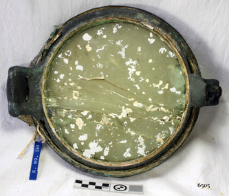 Flagstaff Hill Maritime Museum and Village
Functional object - Porthole, c 1888
This porthole was part of the ship's fittings when the Antares was constructed. THE ANTARES In mid-November 1914, after the beginning of the First World War, a young local man went one evening to fish near the Bay of Islands, west of Peterborough. He later arrived home hurriedly and in an agitated state declaring: "The Germans are coming!" His family laughed and disbelieved him, as this young fellow was prone to telling fictional tales. About a month later, on December 13th 1914, local farmers Phillip Le Couteur and Peter Mathieson were riding in the vicinity, checking on cattle. Phillip Le Couteur saw what he “thought was the hull of a ship below the cliffs.” He rode to Allansford and contacted police. The next day, two Constables and Phillip Le Couteur returned to the site, where they dug a trench near the top of the cliff and sank a log in it. To this they attached a rope, which they threw down the cliff face. Constable Stainsbury and Phillip Le Couteur then made the dangerous descent down the rope on the sheer cliff face. They found wreckage strewn around a small cove and a portion of a man's body under the cliffs. The hull of the ship could be seen about 300 metres out to sea. Some of the wreckage revealed the name Antares and the remains of the ship's dinghy bore the name Sutlej. During the next two weeks and with the help of the Warrnambool lifeboat and crew, two more bodies were found. Later investigations proved that the tragic wreck was indeed that of the Antares, reported overdue on the 207th day of her voyage from Marseilles, France, to Melbourne. She was a three masted, 1749 ton iron clipper, built in Glasgow in 1888 and originally named and launched as the Sutlej. Bought in 1907 by Semider Bros. from Genoa, Italy, she was refitted and renamed Antares. It was later realised that the local lad who a month earlier had declared he had seen German guns being fired, had probably seen distress flares fired from the deck of the Antares the night she was wrecked. She was last sailed under Captain Gazedo and wrecked at what is now known as Antares Rock, near the Bay of Islands. She had been carrying a large cargo of roofing tiles from France to Melbourne, consigned to Mullaly & Byrne. Many of them are now to be seen amongst the battered and scattered remains of the wreck. Some of the timbers were found to be blackened by fire. An Information Board has been erected on the cliff top near to the site of the Antares wreck, at the end of Radfords Rd, west of Peterborough. (Ref: Flagstaff Hill Maritime Village’s “Antares” fact sheet, Victorian Heritage Database, Information Board at Peterborough, Flagstaff Hill Significance Assessment 2010)The Antares was one of the last of the 'tall ships' to be lost along the south west coast of Victoria, and is the only wreck that took the lives of all people on board. She is listed on the Victorian Heritage Register VHS S34. The Antares is significant as a sail trader carrying an international inbound cargo. It is part of the Great Ocean Road Historic Shipwreck Trail. Porthole with glass, brass, screw dog broken off, glass has cracks through it, some encrustation. Artefact Reg No A/5, recovered from the wreck of the Antares.flagstaff hill, warrnambool, shipwrecked-coast, flagstaff-hill, flagstaff-hill-maritime-museum, maritime-museum, shipwreck-coast, flagstaff-hill-maritime-village, porthole, antares., tall ship, peterborough, 1914 shipwreck, phillip le couteur, peter mathieson, constable stainsbury, sutlej, antares rock., bay of islands, ship's fitting