Showing 524 items matching "department of lands "
-
 Bacchus Marsh & District Historical Society
Map, Myrniong Parish Map, County of Bourke, 1882
... Photo-lithographed at the Department of Lands and Survey... Region Parish Plans Photo-lithographed at the Department of Lands ...A single page paper map showing the map for the Parish of Myrniong in the County of Bourke. A cadastral map showing parish boundaries and land ownership. The map is pasted into a bound volume containing 76 maps or plans in total. High resolution digital image stored on BMDHS computer network. Photo-lithographed at the Department of Lands and Survey, Melbourne by J. Noone, 17.7.82myrniong parish plan, myrniong parish maps, bacchus marsh region parish plans -
 Bacchus Marsh & District Historical Society
Map, Parish of Yangardook, County of Bourke 1876
... Photo lithographed at the Department of Lands and Survey... lithographed at the Department of Lands and Survey, Melbourne by J ...The parish of Yangardook lies directly north of the township of Melton. The locality of Toolern Vale lies in the centre of this parish. A single page paper map showing the plan for the Parish of Yangardook in the in the County of Bourke. Scale 40 chains to 1 inch. The map is pasted into a bound volume containing 76 maps or plans in total. High resolution digital image stored on BMDHS computer network. Photo lithographed at the Department of Lands and Survey, Melbourne by J. Noone, 1.8.76yangardook parish maps, toolern vale victoria maps -
 Merbein District Historical Society
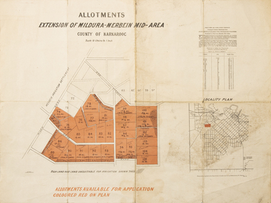
Map - Allotments Extension of Mildura-Merbein Mid-Area, Allotments available, 23 November 1920
... Photo-Lithographed at Department of lands Survey, Melbourne... Irrigation Photo-Lithographed at Department of lands Survey ...Allotments available to Discharged Soldiers Discharged Soldier's Settlement Act Historic Large map, folded in 4, coloured map of Merbein indicating allotments available and locality plan. Scale 10 chain to 1 inchPhoto-Lithographed at Department of lands Survey, Melbourne J. Butson 23.11.20discharged soldiers, ww1, soldier settlement, irrigation -
 Falls Creek Historical Society
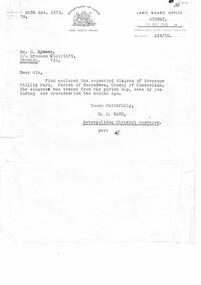
Letter - Letter Re Diagram Of Governor Phillip Park, Parish Of Narrabeen
... A letter from Department of Lands, New South Wales... Department of Lands, New South Wales accompanying a diagram ...Bob Hymans Collection Bob (Herman) Hymans (a former member of the Royal Netherlands Navy) was born in Bloemendaal, Holland on 30th September 1922. During World War II he fought against the Japanese in the Dutch East Indies (now Indonesia) and was imprisoned in Changi and on the Burma Railway. After gaining qualifications as a Ski Instructor, Bob arrived in Falls Creek in July 1950. Working as an Instructor and Supervisor at Bogong Lodge, Bob decided his future was in accommodation. He was successful in negotiating an indenture for land from the State Electricity Commission (SEC). It took Bob two years to build his Grand Coeur Chalet but, tragically, it was burned down in August 1961. Bob also built the first Chairlift in Australia. This was a single chairlift and the structure was built from wooden electricity poles. He was constantly full of new ideas and proposals for the village. Bob Hymans died on 7th July 2007. This Collection of documents and letters tells the story of Bob's endeavours to develop Falls Creek into the ski village it is today.This letter is significant because it reflects the desire for Bob Hymans to consider projects outside of Falls Creek.A letter from Department of Lands, New South Wales accompanying a diagram of Governor Phillip Park. Plans are no longer available.falls creek administration, governor phillip park -
 Bendigo Historical Society Inc.
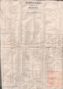
Map - MAP. WARRAGAMBA. COUNTY OF BENDIGO, 1915
... . Diggorra. Kamarooka Photographedat the Department of LANDS.... Kamarooka Photographedat the Department of LANDS AND Survey ...Map. Warragamba. Colunty of Bendigo. Pannoomilloo. Minto. Diggorra. Kamarooka Photographedat the Department of LANDS AND Survey Melbourne by W. J. Butson. -
 Bendigo Historical Society Inc.
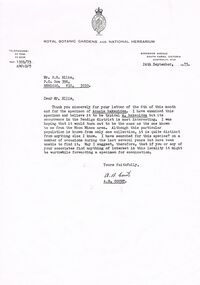
Document - PETER ELLIS COLLECTION: LETTER, 24th September, 1973
... Department of Crown Lands and Survey Victoria... COMMUNICATION Postal letters Peter Ellis Collection Department of Crown ...Letter, dated 24th September, 1973, to Mr P N Ellis from A B Court of the Royal Botanic Gardens and National Herbarium. In the A B Court thanks Mr Ellis for his letter and for the specimen of Acacia hakeoides. He was hoping it would turn out to be the same as the one known to him from the Moon Mines area. He had searched for this species? During the last several years but had been unable to find it. He suggest that if Mr Ellis or his associates find anything of interest in the locality it might be worthwhile forwarding a specimen for examination. Signed A B Court.communication, postal, letters, peter ellis collection, department of crown lands and survey victoria, royal botanic gardens and national herbarium, p n ellis, moon mines area, a b court -
 Bendigo Historical Society Inc.
Map - JACK FLYNN COLLECTION: TARNAGULLA SHEET 4, 25/11/1926
... Photo-Lithographed at the Department of lands and Survey... at the Department of lands and Survey, Melbourne by W. J. Butson. 25.11.26 ...Map: Parish of Tarnagulla Sheet 4, Counties of Gladstone and Bendigo. Parish plan.Photo-Lithographed at the Department of lands and Survey, Melbourne by W. J. Butson. 25.11.26map, gladstone, parish plan, tarnagulla sheet 4 -
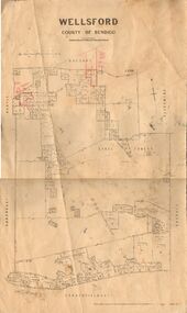 Bendigo Historical Society Inc.
Map - JACK FLYNN COLLECTION: WELLSFORD, 2/11/1914
... Photo-Lithographed at the Department of Lands and Survey... Bendigo parish plan Wellsford Photo-Lithographed at the Department ...Map: Parish of Wellsford, County of Bendigo. Parish plan.Photo-Lithographed at the Department of Lands and Survey Melbourne By H.J. Butson. 2-.11.14map, bendigo, parish plan, wellsford -
 Bacchus Marsh & District Historical Society
Map, Mooradoranook Parish Map, County of Grant
... Photo lithographed at the Department of Lands and Survey... Marsh Region Parish Plans Photo lithographed at the Department ...A single page paper map showing the map for the Parish of Mooradanook in the County of Grant. Cadastral map showing land ownership. The map is pasted into a bound volume containing 76 maps or plans in total. High resolution digital image stored on BMDHS computer network. Photo lithographed at the Department of Lands and Survey Melbourne by T. F. McGauran, 27.11.06mooradoranook parish maps, mooradoranook parish plan, bacchus marsh region parish plans -
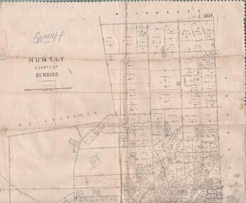 Bendigo Historical Society Inc.
Map - MAP. HUNTLY. COUNTY OF BENDIGO, 1912
... at the Department of lands and Survey. Melbourne byW. J. Butson.... Sandhurst. Photo-lithographed at the Department of lands ...Map. Huntly. County of Bendigo. Wellsford. Bagshot. Nerring. Wirrakee. Sandhurst. Photo-lithographed at the Department of lands and Survey. Melbourne byW. J. Butson -
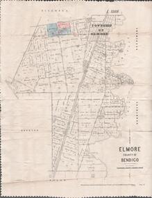 Bendigo Historical Society Inc.
Map - MAP. ELMORE COUNTY OF BENDIGO, 1918
... . Ryunnymead. Egerton Photo-Lithographed at the Department of lands.... Egerton Photo-Lithographed at the Department of lands and Survey ...Map. Elmore County of Bendigo. Diggorra. Burnewang. Ryunnymead. Egerton Photo-Lithographed at the Department of lands and Survey Melbourne, by W. J. Button. 4.7.18 -
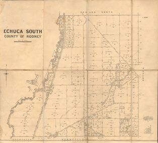 Bendigo Historical Society Inc.
Map - JACK FLYNN COLLECTION: ECHUCA SOUTH, 13/08/1931
... By Authority H. J. Green, Govt. Printer. Department.... J. Green, Govt. Printer. Department of Lands and Survey ...Map: Parish of Echuca South, County of Rodney. Parish plan.By Authority H. J. Green, Govt. Printer. Department of Lands and Survey, Melbourne. 13.8.31map, rodney, parish plan, echuca south , county of rodney -
 Bendigo Historical Society Inc.
Map - JACK FLYNN COLLECTION: KARA KARA, 1932
... . Department of Lands and Survey, Melbourne, 1958..., Government Printer Melbourne. Department of Lands and Survey ...Map: County of Kara Kara, map sheet showing the whole of the County of Kara Kara and all of the Parishes within. Scale 2 miles to 1 inch.By Authority: W.M. Houston, Government Printer Melbourne. Department of Lands and Survey, Melbourne, 1958map, kara kara, county, kara kara -
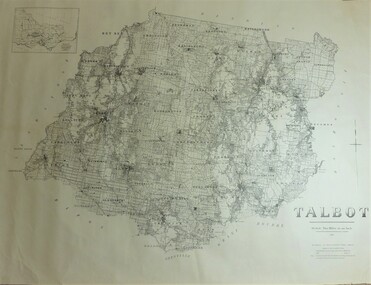 Bendigo Historical Society Inc.
Map - JACK FLYNN COLLECTION: TALBOT, 1937
... . Department of Lands and Survey Melbourne. 1959... Printer, Melbourne. Department of Lands and Survey Melbourne. 1959 ...Map: County of Talbot, map sheet showing the whole of the County of Talbot and all of the Parishes within. Scale 2 Miles to 1 inch.By Authority: A.C. Brooks, Government Printer, Melbourne. Department of Lands and Survey Melbourne. 1959map, talbot, county, talbot -
 Bendigo Historical Society Inc.
Map - JACK FLYNN COLLECTION: COUNTY OF GLADSTONE, 1934
... Engraved at the Department of Lands and Survey Melbourne... Gladstone parish plan Gladstone Engraved at the Department of Lands ...Map: County of Gladstone, map sheet showing the whole of the County and the Parishes within. Scale 2 Miles to 1 inch.Engraved at the Department of Lands and Survey Melbourne. 1958. By Authority of W.M. Houston, Government Printermap, gladstone, parish plan, gladstone -
 University of Melbourne, Burnley Campus Archives
Plan, Richmond Park, 1926-1954
... and hedging dated 1927. Stamp, Department of Lands and Survey 8.9.54..., Department of Lands and Survey 8.9.54 (Original plan dated 25.3.27 ...Photocopy of Section of a Survey Plan 1926 showing fencing and hedging dated 1927. Stamp, Department of Lands and Survey 8.9.54 (Original plan dated 25.3.27) Part of handwritten notes signed "M. Anderson ? 28/2/45."parks, richmond, burnley gardens, orchards -
 Bendigo Historical Society Inc.
Map - JACK FLYNN COLLECTION: SALISBURY, 1965
... . Drawn and Reproduced at the Department of Lands and Survey... Printer, Melbourne. Drawn and Reproduced at the Department ...Map: Parish of Salisbury, County of Bendigo. Parish plan.By Authority A. C. Brooks Government Printer, Melbourne. Drawn and Reproduced at the Department of Lands and Survey, Melbourne.map, bendigo, parish plan, salisbury -
 Bendigo Historical Society Inc.
Map - JACK FLYNN COLLECTION: MUSKERRY, 1962
... . Drawn and reproduced at the Department of Lands and Survey... Printer, Melbourne. Drawn and reproduced at the Department ...Map: Parish of Muskerry, County of Rodney. Parish plan.By Authority: A.C. Brooks, Government Printer, Melbourne. Drawn and reproduced at the Department of Lands and Survey, Melbournemap, rodney, parish plan, muskerry -
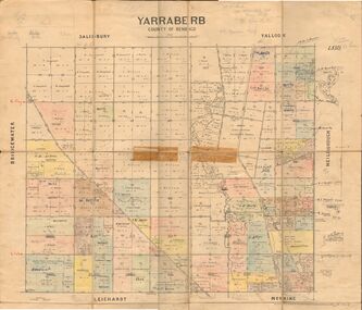 Bendigo Historical Society Inc.
Map - JACK FLYNN COLLECTION: YARRABERB, 2/03/1931
... at the Department of lands and Survey Melbourne, 2.3.31....., Printer. Photo Lithographed at the Department of lands and Survey ...Map: Yarraberb, County of Bendigo. Parish plan.By Authority H.J. Green Govt., Printer. Photo Lithographed at the Department of lands and Survey Melbourne, 2.3.31.map, bendigo, parish plan, yarraberb -
 Bendigo Historical Society Inc.
Map - JACK FLYNN COLLECTION: BET BET, 18/08/1931
... at the Department of Lands and Survey, Melbourne. 18.8.31... at the Department of Lands and Survey, Melbourne. 18.8.31 Map: Parish of Bet ...Map: Parish of Bet Bet, Counties of Gladstone and Talbot . Parish plan.By Authority H.J. Green Govt, Printer. Photo Lithographed at the Department of Lands and Survey, Melbourne. 18.8.31map, gladstone, parish plan, bet bet, counties of gladstone and talbot. -
 Bendigo Historical Society Inc.
Map - JACK FLYNN COLLECTION: YARRAYNE, 6/01/1932
... -Lithographed at the Department of Lands and Survey, Melbourne. 5.1.32....., Printer. Photo-Lithographed at the Department of Lands and Survey ...Map: Parish of Yarrayne, County of Bendigo. Parish plan.By Authority, H.J. Green, Govt., Printer. Photo-Lithographed at the Department of Lands and Survey, Melbourne. 5.1.32.map, bendigo, parish plan, yarrayne -
Stawell Historical Society Inc
Map - Parish Map, Barkley County of Kara Kara 1920's, 1920's ?
... at the Department of Lands and Survey. Melbourne 22.11.2... Printer. Photo Lithographed at the Department of Lands and Survey ...Johnsons Gully LeadPaper map of Parish of BarkelyBy Authority H.J. Green Govt Printer. Photo Lithographed at the Department of Lands and Survey. Melbourne 22.11.2survey -
 Bacchus Marsh & District Historical Society
Map, Mouyong Parish Map, County of Grant
... Photo lithographed at the Department of Lands and Survey... Region Parish Plans Photo lithographed at the Department of Lands ...A single page paper map showing the map for the Parish of Mouyong in the County of Grant. Cadastral map showing land ownership. The map is pasted into a bound volume containing 76 maps or plans in total. High resolution digital image stored on BMDHS computer network. Photo lithographed at the Department of Lands and Survey Melbourne by T. F. McGauran, 9. 4. 07mouyong parish plan, mouyong parish maps, bacchus marsh region parish plans -
Stawell Historical Society Inc
Map, Lexington County of Borong 1910 & 1914, 1910
... Photo Lithographed at the Department of Lands and Survey... Lithographed at the Department of Lands and Survey. Melbourne by T.F ...Parish to the North East of MoystonA2 Parish mapPhoto Lithographed at the Department of Lands and Survey. Melbourne by T.F. McGauran 5.12.10 & W.J. Butson 24.3.14survey -
 Bendigo Historical Society Inc.
Map - JACK FLYNN COLLECTION: GIRGARRE, 1957
... . Drawn and reproduced at the Department of Lands and Survey... Printer, Melbourne. Drawn and reproduced at the Department ...Map: Township of Girgarre, Parish of Kyabram, County of Rodney. Parish plan.By Authority: W. M. Houston, Government Printer, Melbourne. Drawn and reproduced at the Department of Lands and Survey, Melbourne.map, rodney, township, girgarre -
 Bendigo Historical Society Inc.
Map - JACK FLYNN COLLECTION: COHUNA, 1963
... . Drawn and Reproduced at the Department of Lands and Survey... at the Department of Lands and Survey, Melbourne.1963. Map: Photocopy ...Map: Photocopy of parish plan showing Cohuna and a portion of the Gunbower Creek.By Authority. A.C. Brooks Government Printer, Melbourne. Drawn and Reproduced at the Department of Lands and Survey, Melbourne.1963.map, gunbower, parish plan, cohuna , gunbower creek -
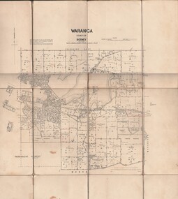 Bendigo Historical Society Inc.
Map - JACK FLYNN COLLECTION: WARANGA, 1959
... . Drawn and Reproduced at the Department of lands and survey... Printer Melbourne. Drawn and Reproduced at the Department of lands ...Map: Parish of Waranga, County of Rodney. Parish plan.By Authority. A.C. Brooks. Government Printer Melbourne. Drawn and Reproduced at the Department of lands and survey. Melbourne 1959.map, rodney, parish plan, waranga -
Tarnagulla History Archive
Telegram, March 1862
... Harding to Frederic Harding at the Department of Lands a& Survey... Chas Harding to Frederic Harding at the Department of Lands ...Donald Clark Collection. A large lot of papers, including this and many other telegrams, were apparently found in the ceiling cavity of the Sandy Creek/Tarnagulla Post and Telegraph Office in the later 20th Century, during building works.Telegram sent from Tarnagulla Telegraph Office from Chas Harding to Frederic Harding at the Department of Lands a& Survey, Melbourne. Text reads "Wait no selling. Gold struck in works'. -
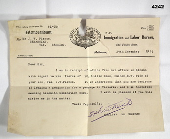 Bendigo Military Museum
Letter - ADMINISTRATION LETTER, 29.11.1916
... is a coat of Arms with “Department of Lands and Survey" around... in black. At th top is a coat of Arms with “Department of Lands ...The letter from the immigration and Labour Bureau revolves around J.W.Pierce getting his sons wife passage to Australia. The son is also J.W.Pierce No 261 21st Batt AIF who was in France. His wife’s name was Hazel whom he married in late 1916. James returned home in 1919, there is no records in his service documents as to his wife getting passage to Australia. This is George Frederick Pierces brother. George won the DCM. Refer Cat No 4136P for his service details, award and death. Part of the collection of William (Bill) Thomason, refer Cat No 4136P for more items.Letter on official letterhead, yellowed colour, printed in black, ref No 16/581, entries typed in black. At th top is a coat of Arms with “Department of Lands and Survey" around the top.“For Mr J.W. Pierce Sebastion Via Bendigo, 29th November 1916”letters, immigration, military -
 Bendigo Historical Society Inc.
Map - JACK FLYNN COLLECTION: TARNAGULLA, 13/05/1922
... . Lithographed at the Department of Lands and Survey, Melbourne by W. J..., Government Printer, Melbourne. Lithographed at the Department ...Map: Parish of Tarnagulla . This Item is in very poor condition.By Authority, A. J. Mullen, Government Printer, Melbourne. Lithographed at the Department of Lands and Survey, Melbourne by W. J. Butsonmap, gladstone, parish plan, tarnagulla