Showing 416 items
matching department of lands and surveys
-
 Bendigo Historical Society Inc.
Map - CORNELLA : COUNTY OF BENDIGO, 13-4-32
... -Lithographed at the Department of Lands and Survey, Melbourne. 13-4-32..., Govt. Printer. Photo-Lithographed at the Department of Lands ...Map. Cornella, County of Bendigo, County of Rodney, Colbinabbin, Gobarup, Redcastle, Toolleen, Kangaroo Creek, Cornella Creek. By authority H.J. Green, Govt. Printer. Photo-Lithographed at the Department of Lands and Survey, Melbourne. 13-4-32. Price 2/-. (number 123 in map cupboard 1)H.J. Green, Govt.Printermap, bendigo, cornella -
Bendigo Historical Society Inc.
Map - BRIDGEWATER : COUNTY OF BENDIGO, 6-10-27
... at the Department of Lands and Survey Melbourne by W.J. Butson, 6-10-27... Railway. Photo-Lithographed at the Department of Lands and Survey ...Map. Bridgewater, County of Bendigo, Inglewood, Salisbury, Derby, Leichardt, Yarraberb, Yarrayne, Bullock Creek, Loddon River, Sandhurst and Inglewood Railway. Photo-Lithographed at the Department of Lands and Survey Melbourne by W.J. Butson, 6-10-27. Price 1/-. (number 53 in map cupboard 1)W.J. Butsonmap, bendigo, bridgewater -
Bendigo Historical Society Inc.
Map - BAMAWM : COUNTY OF BENDIGO, November 1954
... at the Department of Lands and Survey, Melbourne. November 1954. Price 5.... Houston, Government Printer.Drawn and reproduced at the Department ...Map. Bamawm, County of Bendigo. Sheet 2, Pannoobamawm, Diggorra. Elmore to Cohuna Railway Line. Township of Lockington. By authority W.M. Houston, Government Printer.Drawn and reproduced at the Department of Lands and Survey, Melbourne. November 1954. Price 5/- per sheet. (number 52 in map cupboard 1)W.M. Houston, Government Printermap, bendigo, bamawm -
Bendigo Historical Society Inc.
Map - YARRABERB : COUNTY OF BENDIGO, 23-2-15
... at the Department of Lands and Survey, Melbourne by W.J. Butson 23-2-15.... Photographed at the Department of Lands and Survey, Melbourne by W.J ...Map. Yarraberb, County of Bendigo, Salisbury, Yallook, Neilborough, Nerring, Leichardt, Bridgewater. L5373. Photographed at the Department of Lands and Survey, Melbourne by W.J. Butson 23-2-15. Price 1/-.By authority: Albert J. Mullett, Government Printer, Melbourne. (number 16 in map cupboard 1)By authority Albert J. Mullett, Government Printer.map, bendigo, agricultural lands -
Bendigo Historical Society Inc.
Map - KIMBOLTON : COUNTY OF BENDIGO, 1966
... , Government Printer, Melbourne. Drawn and reproduced at the Department..., Melbourne. Drawn and reproduced at the Department of Lands ...Map. Kimbolton, County of Bendigo. Eppalock, Lyell, Knowsley, Langwornor, Redesdale, County of Dalhouse, County of Rodney, Campaspe River, Coliban River,By authority A.C.Brooks, Government Printer, Melbourne. Drawn and reproduced at the Department of Lands and Survey, Melbourne, 1966, Price $1.00 (number 65 in map cupboard 1)A.C. Brooks, Government Printer, Melbourne.map, bendigo, kimbolton -
Bendigo Historical Society Inc.
Map - TANDARRA : COUNTY OF BENDIGO, 14-3-24
... at the Department of Lands and Survey, Melbourne by W.J. Butson,14-3-24... at the Department of Lands and Survey, Melbourne by W.J. Butson,14-3-24 ...Map. Tandarra, County of Bendigo, Talambe, Yallook, Neilborough, Whirrakee, Kamarooka. Photo-Lithographed at the Department of Lands and Survey, Melbourne by W.J. Butson,14-3-24. Price 1/-.Myers Creek, Tandarra Estate. By authority Mullett, Government Printer, Melbourne. (number 24 in map cupboard 1)Albert J. Mullett, Government Printer, Melbourne.map, bendigo, tandarra -
Bendigo Historical Society Inc.
Map - CAMPBELL COLLECTION: BENDIGO AND DISTRICT MAPS, June 1953
... . Drawn and reproduced at the Department of Lands and Survey... and reproduced at the Department of Lands and Survey, Melbourne, Victoria ...Map. Marong, County of Bendigo, Scale 40 chains to 1 inch. Woodstock, Leichardt, Nerring, Sandhurst, Lockwood, Shelbourne. Drawn and reproduced at the Department of Lands and Survey, Melbourne, Victoria. By Authority : W.M. Houston, Government Printer. June 1953. Price 2/-. (number 403 in map cupboard 1)W.M. Houston, Government Printer.map, bendigo, agricultural lands -
Bendigo Historical Society Inc.
Map - BAGSHOT : COUNTY OF BENDIGO, November 1948
... and reproduced at the Department of Lands and Survey, Melbourne, Victoria... at the Department of Lands and Survey, Melbourne, Victoria. November 1948 ...Map. Bagshot. County of Bendigo, Huntly, Whirrakee, Egerton, Goornong, Ellesmere, Wellsford. Reedy Creek, Sandy Creek. Drawn and reproduced at the Department of Lands and Survey, Melbourne, Victoria. November 1948, Price 2/-. By authority J.J. Gourley, Government Printer, Melbourne. (number 46 in map cupboard 1)J.J. Gourley, Government Printer, Melbourne.map, bendigo, bagshot -
Bendigo Historical Society Inc.
Map - GOORNONG : COUNTY OF BENDIGO, September 1943
... . Drawn and reproduced at the Department of Lands and Survey... at the Department of Lands and Survey, Melbourne, Victoria. September 1943 ...Map. Goornong, County of Bendigo, Egerton, Bagshot, Ellesmere, Muskerry, Campaspe, Nolan, Campaspe River, Town of Goornong. By authority : H.E. Daw, Government Printer, Melbourne. Drawn and reproduced at the Department of Lands and Survey, Melbourne, Victoria. September 1943, Price 2/-. (number 44 in map cupboard 1)H.E. Daw, Government Printer, Melbourne.map, bendigo, goornong -
Bendigo Historical Society Inc.
Map - CROSBIE : COUNTY OF BENDIGO, 28-9-76
... at the Department of Lands and Survey, Melbourne, J. Noune,28-9-76. (number... 1878. Photo-Lithographed at the Department of Lands and Survey ...Map. Crosbie, County of Bendigo, County of Rodney, Mt. Pleasant Creek, Weston, Toolleen, Redcastle, Dargile, Knowsley East. W.E. Porter, draughtsman, August 1878. Photo-Lithographed at the Department of Lands and Survey, Melbourne, J. Noune,28-9-76. (number 113 in map cupboard 1)W.E. Porter, Draughtsmanmap, bendigo, crosbie -
 Bendigo Historical Society Inc.
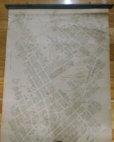
Map - MAP: BENDIGO SHEET 2, 1910, 1910
... of map taken for research purposes. Map prepared by Department... by Department of Lands and Survey, Melbourne by T.F. McGauran 4.1.10 ...Map. Map with timber ends, showing names of property owners. Bendigo from Olinda Street west to Prouses Road and Bennet / Wattle Street to Dooley Street in the north. Copy of map taken for research purposes. Map prepared by Department of Lands and Survey, Melbourne by T.F. McGauran 4.1.10 (1910)map, bendigo, residence areas, 1910 -
Bendigo Historical Society Inc.
Map - YALLOOK : COUNTY OF BENDIGO, 1957
... at the Department of Lands and Survey, Melbourne,1957. Distances shown... at the Department of Lands and Survey, Melbourne,1957. Distances shown ...Map. Yallook, County of Bendigo, Talambe, Neilborough, Yarraberb, Salisbury, Pompapiel. Drawn and reproduced at the Department of Lands and Survey, Melbourne,1957. Distances shown on the plan are derived from original surveys of varying dates and whilst approximately correct do not necessarily conform to modern standards of accuracy. For survey information application should be made to the central plan office, or to the office of titles. Some ink scibbles appear at the right top of this map. Price 2/-. (number 14 in map cupboard 1)By Authority W.M.Houston, Govt.Printer,Melbourne.map, bendigo, yallook -
Stawell Historical Society Inc
Map, Borough of Stawell Parish of Stawell and Illawarra 10/06/1903, 10/06/1903
... Department of Lands and Survey Map of Stawell with marked...Department of Lands and Survey... grampians Department of Lands and Survey Map of Stawell with marked ...Department of Lands and Survey Map of Stawell with marked roads, allotments, physical landmarks. Found in Storage at ANZ Bank when the old archive was being cleaned out. Also shows Surveyed but unused roads. Showed where customers lived in StawellPholtolithograph Map - Paper on canvas backingBorough of Stawell. Parish of Stawell and Illawarra. County of Borong. Scale 8 Chains to 1 Inch. Scale 16 Chains to 1 Inch. Red Ink Writing, Purple and Blue.town -
Bendigo Historical Society Inc.
Map - CAMPBELL COLLECTION: BENDIGO AND DISTRICT MAPS, March 1947
... chains to 1 inch. Drawn and reproduced at the Department of Lands.... Drawn and reproduced at the Department of Lands and Survey ...Map. Mandurang, County of Bendigo, Sandhurst, Strathfieldsaye, Sedgwick, Sutton Grange, Ravenswood, Lockwood. Scale 40 chains to 1 inch. Drawn and reproduced at the Department of Lands and Survey, Melbourne, March 1947, price 2/-. By Authority : J.J. Gourley, Government Printer, Melbourne. (number 402 in map cupboard 1)J.J. Gourley, Government Printer.map, bendigo, allotments -
Bendigo Historical Society Inc.
Map - CAMPBELL COLLECTION: BENDIGO AND DISTRICT MAPS, August 1952
... . Drawn and reproduced at the Department of Lands and Survey... at the Department of Lands and Survey, Melbourne, Victoria, August 1952 ...Map. Nerring, County of Bendigo, Yarraberb, Neilborough, Leichardt, Marong, Sandhurst, Huntly. Scale 20 chains to 1 inch. Drawn and reproduced at the Department of Lands and Survey, Melbourne, Victoria, August 1952. Price 2/-. By Authority J.J. Gourley, Government Printer, Melbourne. (number 404 in map cupboard 1)J.J. Gourley, Government Printermap, bendigo, allotments -
Bendigo Historical Society Inc.
Map - CAMPBELL COLLECTION: BENDIGO AND DISTRICT MAPS, 1963
... . Drawn and reproduced at the Department of Lands and Survey.... Drawn and reproduced at the Department of Lands and Survey ...Map. Sedgwick, County of Bendigo. Scale 20 chains to 1 inch. Strathfieldsaye, Eppalock, Lyell, Mandurang, Sutton Grange, County of Talbot. By Authority A.C. Brooks,Government Printer, Melbourne. Drawn and reproduced at the Department of Lands and Survey, Melbourne.1963. Price 2/-. (number 405 in map cupboard 1)A.C. Brooks, Governmenr Printer, Melbourne.map, bendigo, allotments -
Bendigo Historical Society Inc.
Map - WOODSTOCK : COUNTY OF BENDIGO, 4-7-35
... and Laanecoorie Railway. Drawn and reproduced at the Department of Lands... Railway. Drawn and reproduced at the Department of Lands ...Map. Woodstock, County of Bendigo, Derby, Leichardt, Marong, Shelbourne, Laanecoorie, Tarnagulla. Bradford Creek, Maldon and Laanecoorie Railway. Drawn and reproduced at the Department of Lands and Survey, Melbourne, Victoria.4-7-35. Price 2/-. By authority H.J. Green,Govt. Printer. (number 41 in map cupboard 1)H.J. Green, Govt. Printer.map, bendigo, woodstock -
Bendigo Historical Society Inc.
Map - RUNNYMEDE : COUNTY OF BENDIGO, 8-12-13
... at the Department of Lands and Survey, Melbourne by W.J. Butson.8-12-13... Pleasant Creek. Photo-Lithographed at the Department of Lands ...Map. County of Bendigo, County of Rodney, Burnewang, Elmore, Nolan, Campaspe, Colbinabbin, Burramboot, Corop, Township of Runnymede, Campaspe River, Mount Pleasant Creek. Photo-Lithographed at the Department of Lands and Survey, Melbourne by W.J. Butson.8-12-13. Price 1/-. (number 107 in map cupboard 1)W.J. Butsonmap, bendigo, runnymede -
Bendigo Historical Society Inc.
Map - TOOLLEEN : COUNTY OF BENDIGO, 25-5-26
... . Printer. Photo-Lithographed at the Department of Lands and Survey... at the Department of Lands and Survey, Melbourne by W.J. Butson, 25-5-26 ...Map. Toolleen, County of Bendigo, County of Rodney, Campaspe, Colbinabbin, Cornella, Crosbie, Muskerry, Mount Pleasant Creek, Township of Toolleen. By authority H.J. Green, Govt. Printer. Photo-Lithographed at the Department of Lands and Survey, Melbourne by W.J. Butson, 25-5-26. (number 106 in map cupboard 1)H.J. Green, Govt. Printermap, bendigo, toolleen -
Bendigo Historical Society Inc.
Map - TOOLLEEN : COUNTY OF BENDIGO, 25-5-26
... . Printer. Photo-Lithographed at the Department of Lands and Survey... at the Department of Lands and Survey, Melbourne by W.J. Butson, 25-5-26 ...Map. Toolleen, County of Bendigo, County of Rodney, Campaspe, Colbinabbin, Cornella, Crosbie, Muskerry, Mount Pleasant Creek, Township of Toolleen. By authority H.J. Green, Govt. Printer. Photo-Lithographed at the Department of Lands and Survey, Melbourne by W.J. Butson, 25-5-26. (number 105 in map cupboard 1)H.J. Green, Govt. Printer.map, bendigo, toolleen -
Bendigo Historical Society Inc.
Map - COSTERFIELD : COUNTY OF BENDIGO, 29-10-29
... , Melbourne. Drawn and reproduced at the Department of Lands..., Melbourne. Drawn and reproduced at the Department of Lands ...Map. Costerfield, County of Bendigo, Counties of Dalhousie & Rodney, Dargile, Moormbool West, Warrowitue, Heathcote, Town of Costerfield, Dalhousie. By Authority H.J. Green, Government Printer, Melbourne. Drawn and reproduced at the Department of Lands and Survey, Melbourne. 29-10-29. Price 2/-. (number 92 in map cupboard 1)H.J. Green, Government Printer, Melbourne.map, bendigo, costerfield -
Bendigo Historical Society Inc.
Map - POMPAPIEL : COUNTY OF BENDIGO, 1-10-27
... , Pompapiel Creek, Edeyrn Estate. Photo-Lithographed at the Department..., Edeyrn Estate. Photo-Lithographed at the Department of Lands ...Map. Pompapiel, County of Bendigo, Calivil, Janiember East, Yarrayne, Salisbury, Yallook, Talambe, Judyong Creek, Bullock Creek, Pompapiel Creek, Edeyrn Estate. Photo-Lithographed at the Department of Lands and Survey, Melbourne by W.J. Butson, 1-10-27, Price 1/-. (number 4 in map cupboard 1)W.J. Butson, Government Printermap, bendigo, pompapiel -
Bendigo Historical Society Inc.
Map - POMPAPIEL : COUNTY OF BENDIGO, 1-10-27
... . Photo-Lithographed at the Department of Lands and Survey by W.J... Creek, Blind Creek. Photo-Lithographed at the Department ...Map. Pompapiel, County of Bendigo, Calivil, Talambe, Yallook, Salisbury, Yarrayne, Janiember East, Waranga Mallee Channel, Judyong Creek.Pompapiel Creek, Bullock Creek, Blind Creek. Photo-Lithographed at the Department of Lands and Survey by W.J. Butson, 1-10-27. Price 1/-. (number 84 in map cupboard 1)W.J. Butson.map, bendigo, pompapiel -
Bendigo Historical Society Inc.
Map - SANDHURST : COUNTY OF BENDIGO, 12-7-27
... , Wellsford, City of Bendigo. Photo-Lithographed at the Department.... Photo-Lithographed at the Department of Lands and Survey ...Map. Sandhurst, County of Bendigo. Scale 20 chains to an inch. Huntly, Nerring, Marong, Mandurang, Strathfieldsaye, Wellsford, City of Bendigo. Photo-Lithographed at the Department of Lands and Survey, Melbourne by W.J. Butson12-7-27. Price 1/-. By authority H.J. Green, Govt. Printer. (number 33 in map cupboard 1)H.J. Green, Govt. Printer.map, bendigo, sandhurst -
Bendigo Historical Society Inc.
Map - TANDARRA : COUNTY OF BENDIGO, 14-3-24
... -Lithographed at the Department of Lands and Survey, Melbourne by W.J...-Lithographed at the Department of Lands and Survey, Melbourne by W.J ...Map. Tandarra, County of Bendigo, Talambe, Yallook, Neilborough, Whirrakee, Kamarooka. Myers Creek, Tandarra Estate. Photo-Lithographed at the Department of Lands and Survey, Melbourne by W.J. Butson, 14-3-24. Price 1/-. By authority Albert J. Mullett, Government Printer, Melbourne. (number 25 in map cupboard 1)Albert J. Mullett, Government Printer, Melbourne.map, bendigo, tandarra -
Bendigo Historical Society Inc.
Map - DERBY : COUNTY OF BENDIGO, 1959
... at the Department of Lands and Survey, Melbourne, 1959. Price 5/-. (number..., Government Printer, Melbourne. Drawn and reproduced at the Department ...Map. Derby, County of Bendigo, Inglewood, Tarnagulla, Woodstock, Leichardt, Bridgewater, Loddon River, Bendigo Railway, Calder Highway, Maldon to Bridgewater Road.By authority A.C. Brooks, Government Printer, Melbourne. Drawn and reproduced at the Department of Lands and Survey, Melbourne, 1959. Price 5/-. (number 59 in map cupboard 1)A.C. Brooks, Government Printer, Melbourne.map, bendigo, derby -
Bendigo Historical Society Inc.
Map - CALIVIL : COUNTY OF BENDIGO, 12-12-22
... -Lithographed at the Department of Lands and Survey, Melbourne by W.J... at the Department of Lands and Survey, Melbourne by W.J. Butson,12-12-22 ...Map. Calivil, County of Bendigo, Mologa, Jarklan, Pompapiel, Talambe, Hayanmi. Calivil Creek, Seven Months Creek. Photo-Lithographed at the Department of Lands and Survey, Melbourne by W.J. Butson,12-12-22, Price 1/-. By authority A.J. Mullett, Government Printer, Melbourne. (number 56 in map cupboard 1)A.J. Mullett, Government Printer, Melbourne.map, bendigo, calivil -
Bendigo Historical Society Inc.
Map - EGERTON : COUNTY OF BENDIGO, 29-5-23
... -Lithographed at the Department of Lands and Survey, Melbourne by W.J...-Lithographed at the Department of Lands and Survey, Melbourne by W.J ...Map. Egerton, County of Bendigo, Minto, Giggorra, Elmore, Nolan, Goornong, Bagshot, Whirrakee, Bendigo Creek, Round Creek. By authority A.J. Mullett, Government Printer, Melbourne.Photo-Lithographed at the Department of Lands and Survey, Melbourne by W.J. Butson, 29-5-23. Price 1/-. (number 48 in map cupboard 1)A.J. Mullett, Government Printer, Melbourne.map, bendigo, egerton -
Bendigo Historical Society Inc.
Map - DARGILE : COUNTY OF BENDIGO, November 1953
... , Government Printer. Drawn and reproduced at the Department of Lands... and reproduced at the Department of Lands and Survey, Melbourne. November ...Map. Dargile, County of Bendigo, County of Rodney, Cornella Creek, Northern Highway, Crosbie, Redcastle, Knowsley East, Heathcote, Costerfield, Moormbool West. By authority W.M. Houston, Government Printer. Drawn and reproduced at the Department of Lands and Survey, Melbourne. November 1953. Price 2/-. (number 115 in map cupboard 1)W.M Houston, Government Printermap, bendigo, dargile -
Bendigo Historical Society Inc.
Map - CROSBIE : COUNTY OF BENDIGO, 1970
... , Government Printer, Melbourne. Drawn and reproduced at the Department... Printer, Melbourne. Drawn and reproduced at the Department ...Map. Crosbie, County of Bendigo, County of Rodney, Toolleen, Weston, Dargile, Knowsley East, Redcastle, Township of Toolleen, Northern Highway, Mt.Pleasant Creek. By Authority R.H. Rixon, Government Printer, Melbourne. Drawn and reproduced at the Department of Lands and Survey, Melbourne. 1970. Price $1.00. (number 114 in map cupboard 1)R.H. Rixon, Government Printer, Melbourne.map, bendigo, crosbie