Showing 169 items matching "diamond creek trail"
-
 Eltham District Historical Society Inc
Photograph, Liz Pidgeon, Heritage Excursion; Maroondah Aqueduct, 3 September 2016, 3 September 2016
Newsletter No., 229, August 2016 Heritage Excursion - Maroondah Aqueduct Walk - Saturday 3rd September The Maroondah Aqueduct was once a major link in Melbourne’s water supply system. It was built between 1886 and 1891 to transfer water from the Watts River near Healesville to the Preston Reservoir. It was 66 km in length, made up of 41 km of open channel, 10 km of tunnel through hills and 15 km of pipeline across stream valleys known as inverted siphons. The section of the aqueduct through the Eltham area has been abandoned since the 1980s but the open channel has largely been retained. A recreational path follows the aqueduct reserve. For our excursion on 3rd September we intend to walk along the section of the aqueduct adjacent to Allendale Road. This is a section not visited on previous excursions and includes the transition from open channel to the inverted siphon across the Diamond Creek valley. Apart from the aqueduct itself the main feature of the walk is the extensive views across Eltham North and Diamond Creek. Along the way we will talk about the history of the aqueduct and the area. This easy walk is about 3 km return and will take 2 to 2.5 hours. It will start at 2pm at the junction of Allendale Road with Godber Road and Zig Zag Road North, officially Diamond Creek, but on the northern boundary of Eltham. (Melway ref.12 B10). Born Digitalmaroondah aqueduct, eltham north, activities, eltham district historical society, heritage excursion, aqueduct trail, open channel -
 Eltham District Historical Society Inc
Photograph, Liz Pidgeon, Heritage Excursion; Maroondah Aqueduct, 3 September 2016, 3 September 2016
Newsletter No., 229, August 2016 Heritage Excursion - Maroondah Aqueduct Walk - Saturday 3rd September The Maroondah Aqueduct was once a major link in Melbourne’s water supply system. It was built between 1886 and 1891 to transfer water from the Watts River near Healesville to the Preston Reservoir. It was 66 km in length, made up of 41 km of open channel, 10 km of tunnel through hills and 15 km of pipeline across stream valleys known as inverted siphons. The section of the aqueduct through the Eltham area has been abandoned since the 1980s but the open channel has largely been retained. A recreational path follows the aqueduct reserve. For our excursion on 3rd September we intend to walk along the section of the aqueduct adjacent to Allendale Road. This is a section not visited on previous excursions and includes the transition from open channel to the inverted siphon across the Diamond Creek valley. Apart from the aqueduct itself the main feature of the walk is the extensive views across Eltham North and Diamond Creek. Along the way we will talk about the history of the aqueduct and the area. This easy walk is about 3 km return and will take 2 to 2.5 hours. It will start at 2pm at the junction of Allendale Road with Godber Road and Zig Zag Road North, officially Diamond Creek, but on the northern boundary of Eltham. (Melway ref.12 B10). Born Digitalmaroondah aqueduct, eltham north, activities, eltham district historical society, heritage excursion, aqueduct trail -
 Eltham District Historical Society Inc
Photograph, Liz Pidgeon, Heritage Excursion; Maroondah Aqueduct, 3 September 2016, 3 September 2016
Newsletter No., 229, August 2016 Heritage Excursion - Maroondah Aqueduct Walk - Saturday 3rd September The Maroondah Aqueduct was once a major link in Melbourne’s water supply system. It was built between 1886 and 1891 to transfer water from the Watts River near Healesville to the Preston Reservoir. It was 66 km in length, made up of 41 km of open channel, 10 km of tunnel through hills and 15 km of pipeline across stream valleys known as inverted siphons. The section of the aqueduct through the Eltham area has been abandoned since the 1980s but the open channel has largely been retained. A recreational path follows the aqueduct reserve. For our excursion on 3rd September we intend to walk along the section of the aqueduct adjacent to Allendale Road. This is a section not visited on previous excursions and includes the transition from open channel to the inverted siphon across the Diamond Creek valley. Apart from the aqueduct itself the main feature of the walk is the extensive views across Eltham North and Diamond Creek. Along the way we will talk about the history of the aqueduct and the area. This easy walk is about 3 km return and will take 2 to 2.5 hours. It will start at 2pm at the junction of Allendale Road with Godber Road and Zig Zag Road North, officially Diamond Creek, but on the northern boundary of Eltham. (Melway ref.12 B10). Born Digitalmaroondah aqueduct, eltham north, activities, eltham district historical society, heritage excursion, aqueduct trail, open channel, pipe -
 Eltham District Historical Society Inc
Photograph, Liz Pidgeon, Heritage Excursion; Maroondah Aqueduct, 3 September 2016, 3 September 2016
Newsletter No., 229, August 2016 Heritage Excursion - Maroondah Aqueduct Walk - Saturday 3rd September The Maroondah Aqueduct was once a major link in Melbourne’s water supply system. It was built between 1886 and 1891 to transfer water from the Watts River near Healesville to the Preston Reservoir. It was 66 km in length, made up of 41 km of open channel, 10 km of tunnel through hills and 15 km of pipeline across stream valleys known as inverted siphons. The section of the aqueduct through the Eltham area has been abandoned since the 1980s but the open channel has largely been retained. A recreational path follows the aqueduct reserve. For our excursion on 3rd September we intend to walk along the section of the aqueduct adjacent to Allendale Road. This is a section not visited on previous excursions and includes the transition from open channel to the inverted siphon across the Diamond Creek valley. Apart from the aqueduct itself the main feature of the walk is the extensive views across Eltham North and Diamond Creek. Along the way we will talk about the history of the aqueduct and the area. This easy walk is about 3 km return and will take 2 to 2.5 hours. It will start at 2pm at the junction of Allendale Road with Godber Road and Zig Zag Road North, officially Diamond Creek, but on the northern boundary of Eltham. (Melway ref.12 B10). Born Digitalmaroondah aqueduct, eltham north, activities, eltham district historical society, heritage excursion, aqueduct trail -
 Eltham District Historical Society Inc
Photograph, Liz Pidgeon, Heritage Excursion; Maroondah Aqueduct, 3 September 2016, 3 September 2016
Newsletter No., 229, August 2016 Heritage Excursion - Maroondah Aqueduct Walk - Saturday 3rd September The Maroondah Aqueduct was once a major link in Melbourne’s water supply system. It was built between 1886 and 1891 to transfer water from the Watts River near Healesville to the Preston Reservoir. It was 66 km in length, made up of 41 km of open channel, 10 km of tunnel through hills and 15 km of pipeline across stream valleys known as inverted siphons. The section of the aqueduct through the Eltham area has been abandoned since the 1980s but the open channel has largely been retained. A recreational path follows the aqueduct reserve. For our excursion on 3rd September we intend to walk along the section of the aqueduct adjacent to Allendale Road. This is a section not visited on previous excursions and includes the transition from open channel to the inverted siphon across the Diamond Creek valley. Apart from the aqueduct itself the main feature of the walk is the extensive views across Eltham North and Diamond Creek. Along the way we will talk about the history of the aqueduct and the area. This easy walk is about 3 km return and will take 2 to 2.5 hours. It will start at 2pm at the junction of Allendale Road with Godber Road and Zig Zag Road North, officially Diamond Creek, but on the northern boundary of Eltham. (Melway ref.12 B10). Born Digitalmaroondah aqueduct, eltham north, activities, eltham district historical society, heritage excursion, aqueduct trail, russell yeoman -
 Eltham District Historical Society Inc
Photograph, Liz Pidgeon, Heritage Excursion; Maroondah Aqueduct, 3 September 2016, 3 September 2016
Newsletter No., 229, August 2016 Heritage Excursion - Maroondah Aqueduct Walk - Saturday 3rd September The Maroondah Aqueduct was once a major link in Melbourne’s water supply system. It was built between 1886 and 1891 to transfer water from the Watts River near Healesville to the Preston Reservoir. It was 66 km in length, made up of 41 km of open channel, 10 km of tunnel through hills and 15 km of pipeline across stream valleys known as inverted siphons. The section of the aqueduct through the Eltham area has been abandoned since the 1980s but the open channel has largely been retained. A recreational path follows the aqueduct reserve. For our excursion on 3rd September we intend to walk along the section of the aqueduct adjacent to Allendale Road. This is a section not visited on previous excursions and includes the transition from open channel to the inverted siphon across the Diamond Creek valley. Apart from the aqueduct itself the main feature of the walk is the extensive views across Eltham North and Diamond Creek. Along the way we will talk about the history of the aqueduct and the area. This easy walk is about 3 km return and will take 2 to 2.5 hours. It will start at 2pm at the junction of Allendale Road with Godber Road and Zig Zag Road North, officially Diamond Creek, but on the northern boundary of Eltham. (Melway ref.12 B10). Born Digitalmaroondah aqueduct, eltham north, activities, eltham district historical society, heritage excursion, aqueduct trail -
 Eltham District Historical Society Inc
Photograph, Liz Pidgeon, Heritage Excursion; Maroondah Aqueduct, 3 September 2016, 3 September 2016
Newsletter No., 229, August 2016 Heritage Excursion - Maroondah Aqueduct Walk - Saturday 3rd September The Maroondah Aqueduct was once a major link in Melbourne’s water supply system. It was built between 1886 and 1891 to transfer water from the Watts River near Healesville to the Preston Reservoir. It was 66 km in length, made up of 41 km of open channel, 10 km of tunnel through hills and 15 km of pipeline across stream valleys known as inverted siphons. The section of the aqueduct through the Eltham area has been abandoned since the 1980s but the open channel has largely been retained. A recreational path follows the aqueduct reserve. For our excursion on 3rd September we intend to walk along the section of the aqueduct adjacent to Allendale Road. This is a section not visited on previous excursions and includes the transition from open channel to the inverted siphon across the Diamond Creek valley. Apart from the aqueduct itself the main feature of the walk is the extensive views across Eltham North and Diamond Creek. Along the way we will talk about the history of the aqueduct and the area. This easy walk is about 3 km return and will take 2 to 2.5 hours. It will start at 2pm at the junction of Allendale Road with Godber Road and Zig Zag Road North, officially Diamond Creek, but on the northern boundary of Eltham. (Melway ref.12 B10). Born Digitalmaroondah aqueduct, eltham north, activities, eltham district historical society, heritage excursion, aqueduct trail, open channel -
 Eltham District Historical Society Inc
Photograph, Liz Pidgeon, Heritage Excursion; Maroondah Aqueduct, 3 September 2016, 3 September 2016
Newsletter No., 229, August 2016 Heritage Excursion - Maroondah Aqueduct Walk - Saturday 3rd September The Maroondah Aqueduct was once a major link in Melbourne’s water supply system. It was built between 1886 and 1891 to transfer water from the Watts River near Healesville to the Preston Reservoir. It was 66 km in length, made up of 41 km of open channel, 10 km of tunnel through hills and 15 km of pipeline across stream valleys known as inverted siphons. The section of the aqueduct through the Eltham area has been abandoned since the 1980s but the open channel has largely been retained. A recreational path follows the aqueduct reserve. For our excursion on 3rd September we intend to walk along the section of the aqueduct adjacent to Allendale Road. This is a section not visited on previous excursions and includes the transition from open channel to the inverted siphon across the Diamond Creek valley. Apart from the aqueduct itself the main feature of the walk is the extensive views across Eltham North and Diamond Creek. Along the way we will talk about the history of the aqueduct and the area. This easy walk is about 3 km return and will take 2 to 2.5 hours. It will start at 2pm at the junction of Allendale Road with Godber Road and Zig Zag Road North, officially Diamond Creek, but on the northern boundary of Eltham. (Melway ref.12 B10). Born Digitalmaroondah aqueduct, eltham north, activities, eltham district historical society, heritage excursion, aqueduct trail -
 Eltham District Historical Society Inc
Photograph, Liz Pidgeon, Heritage Excursion; Maroondah Aqueduct, 3 September 2016, 3 September 2016
Heritage Excursion - Maroondah Aqueduct Walk - Saturday 3rd September The Maroondah Aqueduct was once a major link in Melbourne’s water supply system. It was built between 1886 and 1891 to transfer water from the Watts River near Healesville to the Preston Reservoir. It was 66 km in length, made up of 41 km of open channel, 10 km of tunnel through hills and 15 km of pipeline across stream valleys known as inverted siphons. The section of the aqueduct through the Eltham area has been abandoned since the 1980s but the open channel has largely been retained. A recreational path follows the aqueduct reserve. For our excursion on 3rd September we intend to walk along the section of the aqueduct adjacent to Allendale Road. This is a section not visited on previous excursions and includes the transition from open channel to the inverted siphon across the Diamond Creek valley. Apart from the aqueduct itself the main feature of the walk is the extensive views across Eltham North and Diamond Creek. Along the way we will talk about the history of the aqueduct and the area. This easy walk is about 3 km return and will take 2 to 2.5 hours. It will start at 2pm at the junction of Allendale Road with Godber Road and Zig Zag Road North, officially Diamond Creek, but on the northern boundary of Eltham. (Melway ref.12 B10). Newsletter No., 229, August 2016 Abandoned rusty farm machinery possibly used for tilling the soil - off the Aqueduct trail Born Digitalmaroondah aqueduct, eltham north, activities, eltham district historical society, heritage excursion, aqueduct trail, farm machinery -
 Eltham District Historical Society Inc
Photograph, Liz Pidgeon, Heritage Excursion; Maroondah Aqueduct, 3 September 2016, 3 September 2016
Heritage Excursion - Maroondah Aqueduct Walk - Saturday 3rd September The Maroondah Aqueduct was once a major link in Melbourne’s water supply system. It was built between 1886 and 1891 to transfer water from the Watts River near Healesville to the Preston Reservoir. It was 66 km in length, made up of 41 km of open channel, 10 km of tunnel through hills and 15 km of pipeline across stream valleys known as inverted siphons. The section of the aqueduct through the Eltham area has been abandoned since the 1980s but the open channel has largely been retained. A recreational path follows the aqueduct reserve. For our excursion on 3rd September we intend to walk along the section of the aqueduct adjacent to Allendale Road. This is a section not visited on previous excursions and includes the transition from open channel to the inverted siphon across the Diamond Creek valley. Apart from the aqueduct itself the main feature of the walk is the extensive views across Eltham North and Diamond Creek. Along the way we will talk about the history of the aqueduct and the area. This easy walk is about 3 km return and will take 2 to 2.5 hours. It will start at 2pm at the junction of Allendale Road with Godber Road and Zig Zag Road North, officially Diamond Creek, but on the northern boundary of Eltham. (Melway ref.12 B10). Newsletter No., 229, August 2016 Brick bridge on Parsons road, Eltham North over the aqueduct on the aqueduct trail. Born Digitalmaroondah aqueduct, eltham north, activities, eltham district historical society, heritage excursion, parsons road, bridges, aqueduct trail -
 Eltham District Historical Society Inc
Photograph, Liz Pidgeon, Heritage Excursion; Maroondah Aqueduct, 3 September 2016, 3 September 2016
Newsletter No., 229, August 2016 Heritage Excursion - Maroondah Aqueduct Walk - Saturday 3rd September The Maroondah Aqueduct was once a major link in Melbourne’s water supply system. It was built between 1886 and 1891 to transfer water from the Watts River near Healesville to the Preston Reservoir. It was 66 km in length, made up of 41 km of open channel, 10 km of tunnel through hills and 15 km of pipeline across stream valleys known as inverted siphons. The section of the aqueduct through the Eltham area has been abandoned since the 1980s but the open channel has largely been retained. A recreational path follows the aqueduct reserve. For our excursion on 3rd September we intend to walk along the section of the aqueduct adjacent to Allendale Road. This is a section not visited on previous excursions and includes the transition from open channel to the inverted siphon across the Diamond Creek valley. Apart from the aqueduct itself the main feature of the walk is the extensive views across Eltham North and Diamond Creek. Along the way we will talk about the history of the aqueduct and the area. This easy walk is about 3 km return and will take 2 to 2.5 hours. It will start at 2pm at the junction of Allendale Road with Godber Road and Zig Zag Road North, officially Diamond Creek, but on the northern boundary of Eltham. (Melway ref.12 B10). Born Digitalmaroondah aqueduct, eltham north, activities, eltham district historical society, heritage excursion, aqueduct trail -
 Eltham District Historical Society Inc
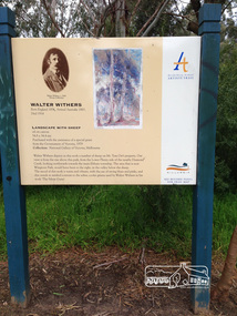
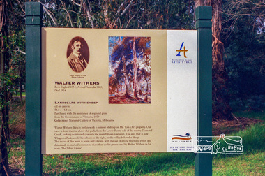
Photograph, Peter Pidgeon, Landscape with sheep by Walter Withers part of the Heidelberg Artist Trail, 2 Sep 2017
The Heidelberg School Artists Trail was established in about 1999 with about 52 signs across four local governemnt areas including Nillumbik and Banyule. This one acknowledges "Landscape with Sheep" by Walter Withers. The text on the board states: Walter Withers depicts in this work a number of sheep on Mr. Tom Orr’s property. Our view is from the rise above this park, from the Lower Plenty side of the nearby Diamond Creek, looking northwards towards the main Eltham township. The area that is now Wingrove Park, would have been to the right, in the valley below the sheep. The mood of this work is warm and vibrant, with the use of strong blues and pinks, and this stands in marked contrast to the softer, cooler greens used by Walter Withers in his work ‘The Silent Gums’. Heritage Excursion by EDHS members - An Eltham South Ramble, 2 Sep 2017Born Digitalactivities, eltham district historical society, eltham south, heritage excursion, local history centre, eltham, heidelberg artists' trail, walter withers, landscape with sheep, wingrove park trail -
 Eltham District Historical Society Inc
Photograph, Heidelberg Artists Trail sign, "Landscape with Sheep" Walter Withers, Wingrove Park, Eltham, c.May 2001
The Heidelberg School Artists Trail was established in about 1999 with about 52 signs across four local governemnt areas including Nillumbik and Banyule. This one acknowledges "Landscape with Sheep" by Walter Withers. The text on the board states: Walter Withers depicts in this work a number of sheep on Mr. Tom Orr’s property. Our view is from the rise above this park, from the Lower Plenty side of the nearby Diamond Creek, looking northwards towards the main Eltham township. The area that is now Wingrove Park, would have been to the right, in the valley below the sheep. The mood of this work is warm and vibrant, with the use of strong blues and pinks, and this stands in marked contrast to the softer, cooler greens used by Walter Withers in his work ‘The Silent Gums’.Roll of 35mm colour negative film, 7 stripsAgfa HDC 200 plus-2eltham, heidelberg artists' trail, wingrove park trail, landscape with sheep, walter withers -
 Eltham District Historical Society Inc
Photograph, Barak Bushlands Reserve, Eltham, March 2003, 2003
This area is urban and wetlands west of the Eltham gateway approach near the bridge over Diamond Creek and forms part of a walking trail. On 15 August 2004, the Shire of Nillumbik officially named the area "Barak Bushlands" as part of its commitment to Aboriginal reconciliation. The naming day memorialised the one hundred and first anniversary of the death of the last full-blood Yarra Aboriginal leader, William Barak. Source: Aboriginal reconcilation events in Nillumbik, Ken Eckersall, 2006.Digital scan from borrowed photobarak bushlands reserve, eltham, walking trail -
 Eltham District Historical Society Inc
Negative - Photograph, Harry Gilham, Diamond Creek in flood, looking west towards Eltham High School (across submerged footbridge), c.Aug. 1996
This (submerged) footbridge has since been replaced by a higher-level bridge and the steps have been abolished.Roll of 35mm colour negative film, 5 of 6 stripsKodak Gold 100-5diamond creek, floods, dalton street, wingrove park trail, eltham high school -
 Eltham District Historical Society Inc
Photograph - Digital Photograph, Alan King, Sign: Clara Southern, Heidelberg School Artists Trail, Main Road, Research, 2008
Warrandyte artist, Clara Southern, features on the Artists Trail. Published: Nillumbik Now and Then / Marguerite Marshall 2008; photographs Alan King with Marguerite Marshall.; p189 Since early in the 20th century this district has attracted artists and other creative people. So much so, that Eltham has been compared to the Left Bank in Paris, New York’s Greenwich Village and London’s Bloomsbury. That is until the 1970s when Eltham rapidly expanded into a suburb. However many artists still flourish not only in Montsalvat, Dunmoochin and the Bend of Islands but elsewhere in Nillumbik. Some artists who have worked or lived in Nillumbik are well-known nationally and internationally. Artists are attracted to the hilly district’s subtle colours, unique light and the Yarra River and Diamond Creek. The railway’s extension to Eltham in 1902 brought artists to paint for the day or to camp. Then many settled in Eltham, perhaps also because the poor quality land, far from the city, was cheap. Following World War Two they found they could build houses and studios cheaply by making their own mud-bricks. The flexible material, with its warm tones blending into the bush, also satisfied their aesthetic sensibilities. As early as 1900, Will Longstaff, known for his painting The Ghosts of Menin Gate at the National War Memorial in Canberra, lived at Stanhope in Peter Street, Eltham, later to become the home of intellectuals Clem and Nina Christensen. Members of Australia’s first significant art movement, the Heidelberg School of Artists, painted in Eltham, Warrandyte and Diamond Creek. Walter Withers lived at the corner of Bolton and Brougham Street, Eltham and taught Sir Hans Heysen, who for a short while stayed with the Withers family. In Warrandyte were Clara Southern, whom Frederick McCubbin taught at the National Gallery School and Penleigh Boyd, who is represented in all Australian state galleries and the National Collection in Canberra. May Vale, daughter of politician William, lived in Diamond Creek. With Jane Price they feature on the Heidelberg School Artists Trail, part of which runs through Nillumbik. The trail includes signs each displaying a reproduction of a painting by an artist and located near where the artist lived or painted. In Nillumbik the trail includes parts of Warrandyte, Eltham in the Alistair Knox Park, Main Road shopping precinct and Wingrove Park, the Research walking track on Main Road and the Diamond Creek Reserve. In 1916 artist William ‘Jock’ Frater lived at the corner of Arthur and Bible Streets, Eltham. Before then, Frater, with other artists including Percy Leason (who moved to Eltham in the mid 1920s) painted in Eltham on weekends. They camped near Bible and Pitt Streets and along the Diamond Creek where the Eltham Retirement Centre now stands.4 In 1921, painter Peter Newbury (father to painter David Newbury, who was born in Eltham) moved to Cromwell Street, Eltham. Max Meldrum, the first Australian painter to formulate a consistent theory of art largely based on tone,5 taught local artists Alan Martin, Clarice Beckett, Peter Glass and Justus Jörgensen. Meldrum visited Eltham then rented a house there for 18 months opposite Wingrove Park. In 1934, artist and architect Justus Jörgensen and his doctor wife Lil and friends built Montsalvat, the artists’ colony. Montsalvat has played an important part in attracting artists to Eltham and its mud-brick, pisé, stone and recycled building materials has had a major influence on Eltham’s built environment. Jörgensen’s students who also helped him build Monstalvat included Arthur Munday, Lesley Sinclair, Helen Lempriere, Joe Hannan, Helen, Sonia and jeweller/sculptor, Matcham Skipper. Among artists who visited Montsalvat were Clifton Pugh and Angry Penguins’ artists Albert Tucker and Arthur Boyd. Some who painted after World War Two were Alan Martin of Eltham and Warrandyte artists Frank Crozier and Harry De Hartog6, one of Melbourne’s first painters influenced by Cubism.This collection of almost 130 photos about places and people within the Shire of Nillumbik, an urban and rural municipality in Melbourne's north, contributes to an understanding of the history of the Shire. Published in 2008 immediately prior to the Black Saturday bushfires of February 7, 2009, it documents sites that were impacted, and in some cases destroyed by the fires. It includes photographs taken especially for the publication, creating a unique time capsule representing the Shire in the early 21st century. It remains the most recent comprehenesive publication devoted to the Shire's history connecting local residents to the past. nillumbik now and then (marshall-king) collection, clara southern, main road, research (vic), heidelberg school artists trail -
 Eltham District Historical Society Inc
Film - Video (VHS), Nillumbik Shire Council, The Nillumbik Story, 1996
PART 1 – NILLUMBIK (00:00-07:17) Opening features various scenes around Nillumbik Shire. For 40,000 years Nillumbik was the home of the Wurundjeri people. Robert Hoddle gave the district its name. Jock Ryan, then president of Nillumbik Historical Society discusses the names Nillumbik and Diamond Creek. In the late 1830s white occupation began with gold found in Warrandyte in 1851 and 12 years later at Diamond Creek -the Diamond Reef which led to the Caledonian gold rush. Jock Ryan discusses the Diamond Creek mine, which was thriving until it burnt out in 1915. Large numbers of workmen moved into area in late 1870s to construct the Maroondah Aqueduct. With growing population of Melbourne, the nearby Yan Yean system had severely disrupted the flow of the Plenty River, forcing the closure of three flour mills there. The aqueduct came to the rescue carrying water 66km from Healesville to Preston. When the Diamond Creek gold mine burnt down the local economy suffered but fruit growing industry had already been established and Diamond Creek became a thriving fruit growing centre. Interview with Jack Powell, a long-time fruiterer at St Andrews market, his family had lived in the area for a hundred years, 3 to 4 generations, “a lot of hard work”. By the time the railway arrived fruit growing was no longer competitive. The railway brought the city closer and day trippers. The Green Wedge separates the shire from the more densely developed neighbours such as Whittlesea, Doncaster, Templestowe, Bulleen and Greensborough. Population at the time (1996) was 19,000 but links to the past remain strong. Mudbrick houses along the Heritage Trail The saving of Shillinglaw Cottage from demolition in 1963 and relocation brick by brick. PART 2 – ENVIRONMENT (07:18-14:44) Peter Brock (with Bev Brock in background) at St Andrews market discusses his childhood growing up in the district and the environment and the values it instilled upon him and his own family. The Brocks have been in the district since the 1860s. Nillumbik Shire responsible for managing three catchment areas; Diamond Creek, Arthurs Creek and Watsons Creek. Follows the course of the Diamond Creek commencing in Kinglake through the district to its confluence with the Yarra River at Eltham at Eltham Lower Park. Highlights Eltham Lower Park community revegetation program and the newly constructed (1996) viewing platform built of new and recycled timbers at the confluence of the Diamond Creek and Yarra River. Also featured are outdoor recreation on the river and at Eltham Lower Park including the Diamond Valley miniature railway. Sugarloaf reservoir and recreational activities and fishing. Aerial view of Memorial Park and Shire of Eltham War Memorial tower at Garden Hill, Kangaroo Ground. Significant tourism opportunities for the shire with 3 million potential day-trippers in metropolitan Melbourne. Council and community working together to find a way to promote the shires natural and artistic assets. At Arthurs Creek, the Brock family and neighbours working together to take care of their waterway. Peter Brock’s uncle, Sandy Brock talks about environmental management and the Arthurs Creek Landcare group and actions to eradicate blackberry problem. Having previously planted Cypress rows they are replacing them with indigenous species to improve the water supply, keeping cattle out of the creek bed to improve the quality downstream flowing into the Yarra. Eltham East Primary School Band playing “All things bright and beautiful” merges into scenes of the bushland sanctuary set aside by the school in 1980 with unidentified teacher discusses the sanctuary and their education program and school children’s comments. Plight of a family of Wedgetail eagles nesting in the path of a developer’s bulldozer at North Warrandyte and actions to save their nesting areas. PART 3 – ARTS (14:45-22:00) Arts and Jazz festival at Montsalvat featuring interviews with Sigmund Jorgensen discussing Montsalvat and its principles. Also Matcham Skipper. Clifton Pugh’s funeral at Montsalvat and his legacy at Dunmoochin near Cottlesbridge with artists in residence, at the time, Chicago artist Charles Reddington who discusses the benefits of the experience. An unidentified female artist also talks about the program and why people are drawn to the area. Unidentified man on street talking about the amount of talent in the area, artists, poets, musicians, authors. Artist Ming Mackay (1918-2009) interviewed talking about the people she mixes with on “the Hill”. Works of local artists are displayed Eltham Library Community Gallery and Wiregrass gallery with a new coffee shop at the Wiregrass making it an even more popular destination. Music at St Andrews Hotel (may be a little bit country) and the Saturday market where likely to hear anything. Sellers and patrons at the market asked about what attracts them to the market and where they came from. Scenes of poets/authors giving readings. CREDITS Music by John Greenfield from the CD Sweet Rain “The Snow Tree”, Uncle Music UNC 2001 Cameras - David Mirabella and Peter Farragher Editor – Olwyn Jones Written and Produced by Jason Cameron A Jason Cameron Proction for Nillumbik ShireProvides a record of the relatively newly created Shire of Nillumbik at the time and the features and attactions of the shire in its people arts, culture and environmentVHS Cassette (five copies) DVD (one copy) Converted to MP4 file format 0:22:00, 1.60GBvideo recording, arthurs creek, arthurs creek landcare group, artists, artists in residence, arts, arts festival, authors, blackberry, brock family, bulldozer, bulleen, bushland sanctuary, caledonian gold rush, charles reddington, clifton pugh, cottlesbridge, cypress rows, developer, diamond creek, diamond creek mine, diamond reef, diamond valley miniature railway, doncaster, dunmoochin, education program, eeps, eltham, eltham east primary school, eltham east primary school band, eltham library community gallery, eltham lower park, environment, fishing, flour mill, fruit growing, fruiterer, garden hill, gold mining, green wedge, greensborough, heritage trail, hurstbridge railway line, jazz festival, jock ryan, kangaroo ground, kangaroo ground tower, kinglake, maroondah aqueduct, matcham skipper, memorial park, ming mackay (1918-2009), montsalvat, mudbrick houses, music, musicians, nesting area, nillumbik historical society, nillumbik shire, north warrandyte, old timer, orchards, peter brock, plenty river, poets, population, recreation, recreational activities, revegetation, robert hoddle, sandy brock, shillinglaw cottage, shire of eltham war memorial, sigmund jorgensen, st andrews hotel, st andrews market, sugarloaf reservoir, templestowe, the hill, tourism, viewing platform, warrandyte, water catchment area, watsons creek, wedgetail eagle, whittlesea, wiregrass gallery, wurundjeri, yarra river, jack powell