Showing 166 items
matching drainage plan
-
 University of Melbourne, Burnley Campus Archives
Plan, Lawn Drainage System, 1986
... Boulevard Richmond melbourne drainage lawns Tracing paper plan dated ...Tracing paper plan dated June 1986 showing details of drainage.drainage, lawns -
 Falls Creek Historical Society
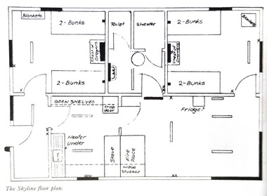
Plan - Floor plan Skyline Lodge, Bogong High Plains
MEYER COLLECTION - FALLS CREEK PHOTOS In 1947 a determined group of like-minded State Electricity Commission (SEC) staff including Ray Meyer, the chief surveyor of the Kiewa Hydro-Electric Scheme, had a common interest that revolved around the skiing potential of the snow-covered high plains which included what is now the resort of Falls Creek. The six SEC employees, Toni St Elmo, Ray Meyer, Jack Minogue, Lloyd Dunn, Adrian Ruffenacht and Dave Gibson (together with their families) banded together to secretly build a 'hut' that was the first ski lodge at Falls Creek. Using a road built in 1930s to gain access to Falls Creek, their hut project was carried out in secret as efforts by other skiers were blocked by H.H.C. Williams – the engineer in charge of the Hydro Scheme. In 1946 Ray Meyer made a trip to the Lands Office in Melbourne. He came away with a 99-year lease on three acres that was ideally suited for a hut designed by Lloyd Dunn. Adrian Ruffenacht (Design Engineer for the KHS) had suggested where the group should build because of easy access to a spring for water. Much of the building material required was scavenged from derelict huts on the high plains. Due to the need for secrecy, the determined group worked on the hut in the evenings and weekends to avoid detection. During the building period the group had met at Echidna Rock (now known as Eagle Rock) where Skippy St Elmo announced, "This is my favourite ‘Skyline’.” And so the first lodge in the area at Falls Creek Ski Resort came into existence. With the development of the International Poma in the 1970s, the Skyline Lodge, which was sited between the ski-lift’s pole one and pole two, was demolished. However, the legacy of Ray Meyer, Toni St Elmo, Jack Minogue, Lloyd Dunn, Adrian Ruffenacht and Dave Gibson and Skyline lives on in the vibrant atmosphere of Falls Creek Resort. The MEYER COLLECTION documents developments on the Kiewa Hydro Scheme and their life at Falls Creek from the mid 1930s to 1960s.This image is significant because it depicts developments made to "Skyline", the first lodge at Falls Creek.A floor plan of Skyline Lodge, probably after renovations were carried out by the Ski Club of Victoria which bought in to Skyline in 1950. In 1951 - 1952 a road up to the Lodge as well as drains, trenches and culverts were added. renovations to the lounge, basement drainage and porch resurfacing were completed in 1955. falls creek, victorian snowfields, skyline lodge -
 Wodonga & District Historical Society Inc
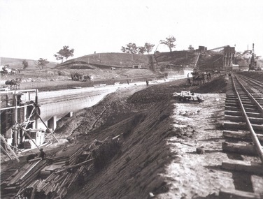
Album - Hume Reservoir Australia Album - Core wall with drainage tunnel and earth embankment in progress in Victoria, June 1924
This set of photos is from a leather bound album bearing the inscription "HUME RESERVOIR AUSTRALIA" plus 'The Rt. Hon. L. C. M. S. Amery, P. C., M .P.' all inscribed in gold. It was presented to The Rt. Hon. L. C. M. S. Amery, P. C., M. P, Secretary of State for Dominion Affairs on the occasion of his visit to the Hume Reservoir on 2nd November 1927. This album is of local and national significance as it documents the planning and development of the Hume Reservoir up to 1927. It was the largest water reservoir in the British Empire. The album records the pioneering engineering work that went into its construction.DEPARTMENT OF PUBLIC WORKS, N.S.W. RIVER MURRAY WATERS SCHEME. HUME RESERVOIR. 14. Core wall with drainage tunnel and earth embankment in progress in Victoria, June 1924.hume reservoir australia, river murray waters scheme, hume reservoir construction -
 Port Melbourne Historical & Preservation Society
Document - Scrapbook relating to Port Melbourne, Newspaper Cuttings, 1900
98 pages of clippings kept by Port Melbourne Town Clerk E.C. CROCKFORD; sequential to item 162. (This also has his bowling scores in back). NB Crockford supposed to have moved to South Melbourne in November, 1909, but this book kept up to 28-07-1910, apparently still in Crockford's handwriting.Notationslocal government - town of port melbourne, engineering - board of works, melbourne harbor trust - port of melbourne authority, sandridge lagoon, livestock, piers and wharves - miscellaneous, amalgamation, royal visits and occasions, law, sport - lawn bowls, transport - tramways, health - general health, business & traders - dairies, flood, transport - horse, transport - railways, environmental issues, fishermans bend, engineering - canals and drainage, built environment - domestic, celebrations fetes and exhibitions, town planning - proposals shelved, natural environment, edward c crockford, town clerks, pumping station, waste disposal, sand carters, business and traders - hotels -
 Bacchus Marsh & District Historical Society
Map, Bacchus Marsh Tuesday 23rd Oct. 1888, Lodge & Dunn's Paddocks 1888. Business and Mansion Sites
This map was created as a plan for an auction of land close to the Bacchus Marsh Railway Station. The auction took place on 23 October 1888. 102 allotments of land from an area known as Lodge and Dunn's paddocks was offered for sale. The auction was conducted by auctioneers based in Melbourne and was advertised in Melbourne newspapers as well as in the Bacchus Marsh Express newspaper. The auction plan contains a range of details including the selling agents, Munro and Baillieu; W.P. Lockhart; and John Turner, all of Melbourne, deposit terms for purchases, price of railway passes for a return trip from Melbourne to Bacchus Marsh of 1 shilling, and a description of the land as having 'magnificent views and perfect drainage'. A single page paper map showing allotments of land for sale along the Parwan Road in Maddingley. The map is pasted into a bound volume containing 76 maps or plans in total. High resolution digital image stored on BMDHS computer network. At bottom on left side: 'Harston & Co. Lith, Melb.'land sales bacchus marsh, land sales maddingley, bacchus marsh victoria maps, maddingley victoria maps -
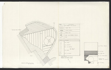
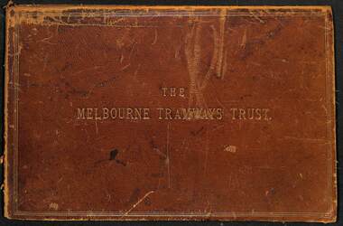 Melbourne Tram Museum
Document - Folder, Kemp & Boyce Printers, "Melbourne Tramways Trust - Cable Tramways", March 1889
Plans and documents prepared by George Duncan for the Melbourne Tramways Trust showing details of the track construction, drainage and costs for the construction of the Melbourne cable tram and horse tram system for the Melbourne and Tramway Omnibus Co. Part 1 - track cross sections for both cable and horse trams and various rail weights - lbs/yard part 2 - details costs and mileages for each liine, report from George Duncan and remnant part of a printed map missing the lower half. part 3 - drainage report detailing the works and cost for each line. part 4 - continuation of drainage report - and last part of the book Map printed on cloth - blue print - showing the various lines. Note the Windsor to St Kilda line shown as a horse tram line, but was built as a cable line - the last to be opened.Yields information about the construction of the cable tram system by the Melbourne Tramway TrustFolder - heavy card leather covered covers with gold lines around the edges and gold blocked title. Has marbled glued end papers, containing 9 cloth backed blue print drawings, 22 printed sheets and two foldout maps. The lower half of the first fold out map has been torn out and lost. The second fold out map, a cloth backed blue print.Date stamped in two places with "The Melbourne Tramways Trust Engineers 9 Mar 89" (1889), in two places.tramways, trams, cable trams, mtt, mtoco, melbourne tramway trust, construction, drainage, maps, george duncan, track work, costs -
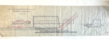 Port Melbourne Historical & Preservation Society
Plan - Suggested Alterations, Port Melbourne Pumping Station, Engineering Department, City of Port Melbourne
... Engineering - Canals and Drainage Sandridge Lagoon Plan ...Plan showing suggested alterations to Port Melbourne Pumping Station, date unknown.engineering - canals and drainage, sandridge lagoon -
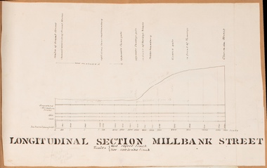 Bacchus Marsh & District Historical Society
Drawing, Longitudinal Section Millbank Street Bacchus Marsh circa 1905
Millbank Street is a short street located close to the central business and shopping area of Bacchus Marsh. In the early 1900s works to improve the drainage of the street were discussed and planned by Bacchus Marsh Shire Council. This plan is most probably the plan discussed at a Shire Council meeting in April 1905. Single page plan showing a longitudinal section view of MIllbank Street running from Clarinda Street to Grant Street in Bacchus Marsh. The names of Millbank Street property owners, Cain, Shelley, Oliver and Ramsay are marked on this plan. Scale: Vertical 10 feet to 1 inch. Horizontal: 100 links to 1 inch Part of a set of maps which are pasted into a bound volume containing 76 maps or plans in total. High resolution digital image stored on BMDHS computer network. bacchus marsh victoria maps, millbank street bacchus marsh -
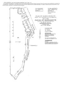
 Ringwood and District Historical Society
Map - Plans of Subdivision, Part of Crown Allotments 35 & 39, Parish of Warrandyte
Survey maps of stages 1, 2 & 3 of residential allotments in Kalinda Road and Grayling Crescent, Ringwood, Victoria. (Undated, circa 1960). Some allotments are marked with real estate information and prices in pre decimal £s.Adshead & McGuire, Land Surveyors L.S. M.I.S. (Aust), 268 Albert Street East Melbourne (Ref 118/2a b &c) Tel 41-6960. The land colored blue is set apart for drainage & sewerage purposes. Reference Marks (R.M's) are Gal Iron Pipes 12"x1". Levels shown are to M.M.B.W. Datum. The land shown hatched is subject to innundation. -
 Ringwood and District Historical Society
Document - Subdivision Plan, LP113220 Part of Crown Allotments 35 & 39B, Parish of Warrandyte, County of Mornington, Vol 6421 Fol 183 & 184 - 1965
LANDATA Land Victoria 2-sheet plan printout dated 2009Sheet 1 includes Kalinda Road, Ringwood. Additional markings include LP113117. Sheet 2 includes Kalinda Road and Maroondah Highway, Ringwood. Additional markings include LP86253. Both sheets include location of Drainage and Sewerage Reserve along Mullum Mullum Creek. -
 Ringwood and District Historical Society
Document, Plan of Subdivision - Part of Crown Portion 5, Parish of Ringwood, County of Bourke - (Undated)
... and land coloured blue appropriated or set aside for drainage ...Map showing layout of 4 numbered allotments coloured red and land coloured blue appropriated or set aside for drainage and sewerage puposes.Map includes Nelson Street and Ringwood Street, Ringwood, Vic. -
University of Melbourne, Burnley Campus Archives
Plan - Photocopy, Edward Owens, Contour Plan of the Town of Richmond, 1873
Photocopy of Contour Plan of the Town of Richmond prepared by M. Egan, Architect and Edward Owens, Cont. Surveyor, 25.03.1873. Plan C. Shows proposed Main Drains and Horticultural Garden. From State Library of Victorian VSL 821.08 Richmond 1873"State Library Vic." in inkdrainage, burnley horticultural gardens, m. egan, edward owens, town of richmond, contour plan -
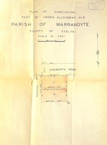 Ringwood and District Historical Society
Document - Plan of Subdivision, Part of Crown Allotment 31B, Parish of Warrandyte, County of Evelyn - (undated, circa 1960s)
Map showing residential allotments numbered 1 and 2 on Through Road and Unsworth Road, Ringwood, Vic., with property dimensions and location of drainage & sewerage easement.H.J. Macey Licensed Surveyor, 36 Nerissa Street, Burwood (Telephone) BX1917. -
University of Melbourne, Burnley Campus Archives
Plan, Duck Pens at Burnley Competitions. Plan of Floor No 1, c. 1940
... duck pens drainage Hand drawn plan, coloured. Plan of Floor ...Hand drawn plan, coloured. Plan of Floor of Duck Pens with Level for Drain. Imperial measurements, so before 1966.duck pens, drainage -
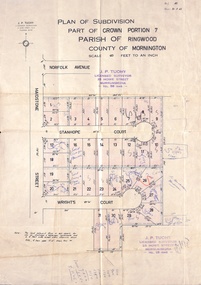 Ringwood and District Historical Society
Document, Plan of Subdivision - Part of Crown Portion 7, Parish of Ringwood, County of Mornington - 1962
Map of residential allotments coloured red, with land coloured blue set apart for drainage & sewerage easements. Rubber stamped J.P. Tuohy, Licensed Surveyor, 25 Howe Street Murrumbeena, Tel. 561945, dated 38.8.1962.Map includes Maidstone Street, Norfolk Avenue, Stanhope Court and Wrights Court, Ringwood, Vic. Also includes handwritten Estate Agent sales notations. -
 Ringwood and District Historical Society
Document - Plan of Subdivision, Part of Crown Allotment 31B, Parish of Warrandyte - 1965
Map showing residential allotments numbered 1, 2, 4 and 5, on Through Road, Ringwood, Vic., with property dimensions, including weatherboard house and galvanised iron garage on lot 2.Kirkpatrick & Webber, Licensed Surveyors, Civil Engineers & Town Planners, Maroondah Highway, Ringwood, Telephone 8700321. Ref 3438C. Date 4th December, 1964. Amended 19th July, 1965. Notation: "The land coloured blue is a drainage and sewerage easement. Levels are to Board of Works Datum. Lot number 3 has been omitted."