Showing 161 items
matching drainage works
-
 Port Melbourne Historical & Preservation Society
Book, Public Works Committee, Borough of Sandridge, Municipal Council of Sandridge - Public Works Committee Minutes, 18560 - 1862
Volume of minutes of Public Works Committee of Sandridge Council dated 20.9.1860Title on labellocal government - borough of sandridge, engineering - roads streets lanes and footpaths, engineering - fences, engineering - canals and drainage, engineering - bridges, fishermans bend, built environment - civic, transport - horse, utilities - gas, sandridge lagoon, mission to seafarers, emerald hill, fire and fire services, william morley, joseph weaver allen, thomas swallow, samuel george isaacs, frederick poolman, robert byrne, john murphy -
Port Melbourne Historical & Preservation Society
Document - Scrapbook relating to Port Melbourne, Newspaper Cuttings, 1900
98 pages of clippings kept by Port Melbourne Town Clerk E.C. CROCKFORD; sequential to item 162. (This also has his bowling scores in back). NB Crockford supposed to have moved to South Melbourne in November, 1909, but this book kept up to 28-07-1910, apparently still in Crockford's handwriting.Notationslocal government - town of port melbourne, engineering - board of works, melbourne harbor trust - port of melbourne authority, sandridge lagoon, livestock, piers and wharves - miscellaneous, amalgamation, royal visits and occasions, law, sport - lawn bowls, transport - tramways, health - general health, business & traders - dairies, flood, transport - horse, transport - railways, environmental issues, fishermans bend, engineering - canals and drainage, built environment - domestic, celebrations fetes and exhibitions, town planning - proposals shelved, natural environment, edward c crockford, town clerks, pumping station, waste disposal, sand carters, business and traders - hotels -
 Port Melbourne Historical & Preservation Society
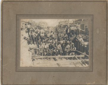
Photograph - Workers in main drain excavation, Princes Street, Port Melbourne, 1933
... in third row from front Princes Street Engineering - Board of Works ...Given to member Jan MacDONALD by Beryl nee BROWN , whose father is one of the workers in the photo. Appears to be an original photo but an enlargement reveals it's a half- tone , so could have been copied from a publication. 'Gus' BROWN appears in third row from front 1933 photograph of construction workers in the excavation for the main drain in Princes Street. Sepia, mounted on cardboard 'frame'. Appears to be an original but is actually a halftone.Top left on back, in ink 'Kelly'princes street, engineering - board of works, engineering - canals and drainage, business and traders - hotels, sydney 'gus' brown, built environment - domestic, built environment - commercial, swallow & ariell ltd -
 Port Melbourne Historical & Preservation Society
Photograph - Photograph (digitally restored), Workers in main drain excavation, Princes Street, Port Melbourne, Appro Images, 1933
... Princes Street Engineering - Board of Works Engineering ...Digitally restored print of 1933 photograph of construction workers in the excavation for the main drain in Princes Street (799.01).princes street, engineering - board of works, engineering - canals and drainage, business and traders - hotels, sydney 'gus' brown, built environment - domestic, built environment - commercial, swallow & ariell ltd -
 Ballarat Tramway Museum
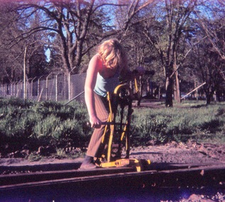
Slide - 35mm slide/s - set of 9, John Theodore, 1972 - 1974
Yields information about depot activities of the BTPS in building the depot fan and access track.Set of 9 AGFA blue and white plastic mount 27mm sq slides of various works at the BTPS depot during 1973 / 1974. .1 - Campbell Duncan operating a rail hole drill. .2 - Track construction - installation of No. 1 roadway commenced. .3 - ditto with overhead works - Warren Doubleday, Bill Kingsley, Clyde Croft and Noel Gipps .4 - ditto .5 - ditto .6 - overhead work .7 - laying a drainage pipe at the rear of the depot .8 - ditto - Loddington .9 - forming the cut off walls at the front of the depot.Various notations by John as to the slide number and the trams in pencil and ink.tramways, trams, btps, depot, track construction -
 Melbourne Tram Museum
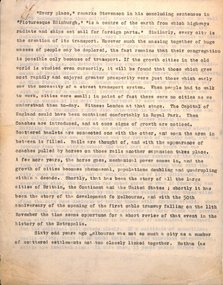
Document, Melbourne & Metropolitan Tramways Board (MMTB), Melbourne cable tram history, late 1930's
Manuscript - 29 quarto sheets carbon copy - article for publication possibly about the history of the Melbourne cable tram system. Notes cover - the background of history of city transport, the suburban councils, the formation of the MTOC, the MTT - list the various council representatives, development of the cable system, Mr. George Duncan, Dunedin, construction works, maintenance, finances, funding, contractors, construction timing, list of lines and opening dates, winding houses, the various lines, construction issues with drainage, cable lengths, horse trams. The conversion of cable trams, annual returns for 1886 to 1935. Page 22 has a heading "Why a Prophecy was Unfulfilled" - which looks at the finances of the MTT and the folding into the Tramway Board and then the MMTB, including community obligations, the MMTB Act, conversion operations, the Chairman's tour of 1923, St Kilda Road conversion, and finally conversion of Elizabeth St and Victoria St. Article dated mid to late 1930's.trams, tramways, cable trams, melbourne, public transport, history, mto co, mtt, dunedin tramways, finances, contracts, cables, construction, track construction, conversion, mmtb, chairman, community services -
 Melbourne Tram Museum
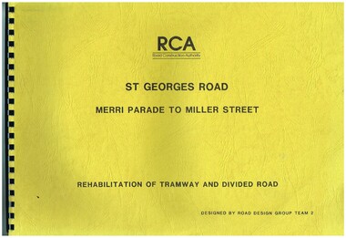
Drawing, Road Construction Authority(RCA), "St Georges Road - Merri Parade to Miller St - Rehabilitation of Tramway and Divided Road", Dec. 1988
Set of two comb bound drawings for the "St Georges Road - Merri Parade to Miller St - Rehabilitation of Tramway and Divided Road", stippled card covers, providing details of plans, drainage, cross sections, track locations for the reconstruction of the roadway. Prepared Dec. 1988, used 1989. 621.2 Second volume titled "Amended Cross Sections" Prepared by the Road Construction Authority - RCA - Road Design Group Team 2. See Reg item 2653 for reports prior to the work being undertaken.trams, tramways, st georges rd, thornbury, northcote, tramways, road works, construction -
 Bacchus Marsh & District Historical Society
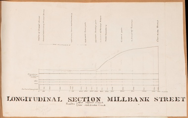
Drawing, Longitudinal Section Millbank Street Bacchus Marsh circa 1905
... 1900s works to improve the drainage of the street were discussed... 1900s works to improve the drainage of the street were discussed ...Millbank Street is a short street located close to the central business and shopping area of Bacchus Marsh. In the early 1900s works to improve the drainage of the street were discussed and planned by Bacchus Marsh Shire Council. This plan is most probably the plan discussed at a Shire Council meeting in April 1905. Single page plan showing a longitudinal section view of MIllbank Street running from Clarinda Street to Grant Street in Bacchus Marsh. The names of Millbank Street property owners, Cain, Shelley, Oliver and Ramsay are marked on this plan. Scale: Vertical 10 feet to 1 inch. Horizontal: 100 links to 1 inch Part of a set of maps which are pasted into a bound volume containing 76 maps or plans in total. High resolution digital image stored on BMDHS computer network. bacchus marsh victoria maps, millbank street bacchus marsh -
 Bendigo Historical Society Inc.
Document - RAE'S CRUSHING BATTERY - THE RICH VICTORIA HILL
Eleven pages including four pages of photocopied photos, They are:- Wm Rae's Crushing Works, The Victoria Quartz Mine, Looking North from Old Chum Hill to the Victoria Hill early 1870's, Victoria Hill from Rae's Open Cut. Notes begin at page 4, there are two page 6 and no page 7, otherwise same notes as 3573.1. Small note with 'Notes on Victoria Hill - incomplete. Notes prepared by Albert Richardson.document, gold, rae's crushing battery, rae's crushing battery, wm rae's crushing works, victoria quartz mine, view from old chum hill to the victoria hill, victoria hill from rae's open cut, ballerstedt, lansell's bit 180, dickers mining record 23/11/1861, j n macartney bendigo goldfields registry 1871, new chum syncline, cleopatra needle type chimney, victoria quartz coy, annals of bendigo, australian mining standard special edition 1/6/1899, bendigo advertiser, bendigo & vicinity 1895, h harkness & sons, new chum drainage scheme, eureka extd, new chum railway, pearl, inrush of water at victoria quartz mine, floyd's small 5 head crushing battery, great central victoria (midway), midway, midway no 2, midway north, ballerstedt's small 24 yard claim, the humboldt, wittscheibe, the adventure, bendigo mines ltd, luffsman & sterry's claim, round shaft, chinese joss house, fortuna -
Port Melbourne Historical & Preservation Society
Plan - MMBW Drainage plan for 184 Dow Street Port Melbourne
Melbourne Metropolitan Board of Works plan for 184 Dow Street.mmbw, engineering - melbourne metropolitan board of works, dow street -
 Ringwood and District Historical Society
Document - Plan of Subdivision, Part of Crown Allotment 31B, Parish of Warrandyte - 1965
Map showing residential allotments numbered 1, 2, 4 and 5, on Through Road, Ringwood, Vic., with property dimensions, including weatherboard house and galvanised iron garage on lot 2.Kirkpatrick & Webber, Licensed Surveyors, Civil Engineers & Town Planners, Maroondah Highway, Ringwood, Telephone 8700321. Ref 3438C. Date 4th December, 1964. Amended 19th July, 1965. Notation: "The land coloured blue is a drainage and sewerage easement. Levels are to Board of Works Datum. Lot number 3 has been omitted."