Showing 157 items
matching early explorers
-
 Wooragee Landcare Group
Photograph, 2004
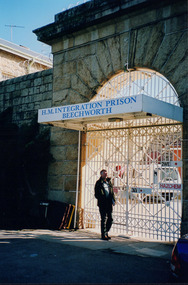
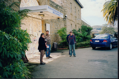
This photo was taken in 2004 and pictures Greg Johnson, who worked at Agriculture Victoria (formerly known as the Department of Primary Industries, DPI), outside Beechworth Prison. This was the last year Wooragee Landcare Group met with Beechworth Prison Farm and Industry Managers at the prison itself, where they discussed weed and rabbit control on the prison's 'Rockery' block. The weed and rabbit controls that were explored in this event aimed to educate people on how to manage common pests in the Wooragee landscape and improve the appearance of the Beechworth Prison. The Beechworth prison itself is significant as it was built between 1859 and 1864 and is designed using a radiating 'panopticon' method which had proved an efficient, cost-effective design for easy surveillance of prisoners by allowing guards to watch over a large area from a central observation point. The prison is historically significant for its association with the early development of Beechworth as the government administrative centre of north-eastern Victoria. It is part of a major precinct of public buildings and has links to numerous other places in Beechworth which used granite quarried and broken at the prison by male inmates. It is also significant for its associations with the bushranger Ned Kelly and the Kelly storyThe photo holds significance due to the social and educational context the image holds in representing the events Wooragee Landcare Group held in order to educate the public. The photograph also exemplifies the historic significance of the area due to the Beechworth Prison's relation to important historical eras and events.Portrait coloured photograph printed on gloss paperReverse: WAN NA E0NA0N2. NNN- 3 2906 / [PRINTED] (No.13) / 868wooragee, wooragee landcare, wooragee landcare group, beechworth prison, h.m beechworth prison, beechwoth gaol, ned kelly, greg johnson, agriculture victoria, department of primary industries, dpi -
 Wooragee Landcare Group
Photograph, 2004
This photo was taken in 2004 and pictures Luke Bailey and Glen Scholfield, the Wooragee Landcare Group coordinator, outside Beechworth Prison. This was the last year Wooragee Landcare Group met with Beechworth Prison Farm and Industry Managers at the prison itself, where they discussed weed and rabbit control on the prison's 'Rockery' block. The weed and rabbit controls that were explored in this event aimed to educate people on how to manage common pests in the Wooragee landscape and improve the appearance of the Beechworth Prison. The Beechworth prison itself is significant as it was built between 1859 and 1864 and is designed using a radiating 'panopticon' method which had proved an efficient, cost-effective design for easy surveillance of prisoners by allowing guards to watch over a large area from a central observation point. The prison is historically significant for its association with the early development of Beechworth as the government administrative centre of north-eastern Victoria. It is part of a major precinct of public buildings and has links to numerous other places in Beechworth which used granite quarried and broken at the prison by male inmates. It is also significant for its associations with the bushranger Ned Kelly and the Kelly storyThe photo holds significance due to the social and educational context the image holds in representing the events Wooragee Landcare Group held in order to educate the public. The photograph also exemplifies the historic significance of the area due to the Beechworth Prison's relation to important historical eras and events.Landscape coloured photograph printed on gloss paperReverse: WAN NA E0NA0N2. NN1- 1 2906 / [PRINTED] (No.15) / 870wooragee, wooragee landcare, wooragee landcare group, beechworth prison, h.m beechworth prison, beechwoth gaol, ned kelly, greg johnson, agriculture victoria, department of primary industries, dpi -
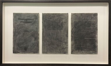 Merri-bek City Council
Work on paper - Charcoal and pages from Aboriginal Words and Place Names, Jenna Lee, Without us, 2022
Jenna Lee dissects and reconstructs colonial 'Indigenous dictionaries' and embeds the works with new cultural meaning. Long obsessed with the duality of the destructive and healing properties that fire can yield, this element has been applied to the paper in the forms of burning and mark-making. In Without Us, Lee uses charcoal to conceal the text on the page, viewing this process as a ritualistic act of reclaiming and honouring Indigenous heritage while challenging the oppressive legacies of colonialism. Lee explains in Art Guide (2022), ‘These books in particular [used to create the proposed works] are Aboriginal language dictionaries—but there’s no such thing as “Aboriginal language”. There are hundreds of languages. The dictionary just presents words, with no reference to where they came from. It was specifically published by collating compendiums from the 1920s, 30s and 40s, with the purpose to give [non-Indigenous] people pleasant sounding Aboriginal words to name children, houses and boats. And yet the first things that were taken from us was our language, children, land and water. And the reason our words were so widely written down was because [white Australians] were trying to eradicate us. They thought we were going extinct. The deeper you get into it, the darker it gets. But the purpose of my work is to take those horrible things and cast them as something beautiful.’Framed artwork -
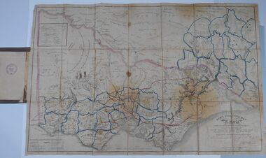 Bendigo Historical Society Inc.
Document - HARRIS COLLECTION: HAMS SQUATTING MAP OF VICTORIA, PORT PHILLIP DISTRICT, NSW
Thomas Ham was a cartographer, engraver, lithographer and publisher in Victoria and Queensland. He compiled and printed several editions of his squatting map, beginning with A map of Australia Felix in 1847 and changing its title to Ham's squatting map of Victoria in 1851. The 1851 edition was accompanied by a key listing the names of all the squatters within squatting districts and counties. Later editions show the existing counties, but some areas of Gippsland and the Australian Alps are still described as 'unsurveyed country'. (State Library Victoria https://www.slv.vic.gov.au/squatting-map-victoria)Folding map enclosed in burgundy cover. Map backed by cloth and bound. Rare, early map of Victoria and neighbouring Port Phillip District of New South Wales. Written on bottom RH corner of map: Ham's Squatting Map of Victoria ( Port Phillip District, New South Wales ) carefully corrected to this date from the Colonial Government Surveys, Crown Lands, Commissioners & Explorers Maps, Private Surveys & c. Respectfully inscribed (with permission ) to His Excellency Sir Chas A. Fitz-Roy Knt, Governor of New South Wales &c &c by his Obedient Servant, The Compiler, 1851. Compiled, engraved and published by Thomas Ham, Melbourne. Proposed and original boundary ( in legend) have been coloured in in blue and pink ink ( later addition ?) Number on map show 'reference to proprietor's Printed on back of map ' J.G. AD 1852, with two cross hatched decorations and two hearts entwined. On other back panel in pencil enclosed in a drawn frame ' G.S.H., 1889, Axedale' (George Harris, Axedale, belongs in Harris Collection) Stamped in purple ink 'Royal Historical Society of Victoria, Bendigo Branch. Written 1959, 53.map, victoria, squatting map -
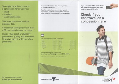 Melbourne Tram Museum
Pamphlet, Public Transport Victoria (PTV), "Check if you can travel on a concession fare", late 2017 to 4/19
.1 - Three fold, DL titled "Check if you can travel on a concession fare", issued late 2017 early 2018 with images of allowable concession cards, including senior and other concession card. ..2 - Five fold DL titled "Your go-to guide to myki" explaining the Myki system costs, types, the Explorer pack for visitors and has a map of the CBD Free Tram Zone. .3 - two fold DL titled "Explore the Night" giving details of night services for trains, trams, bus and coaches. .4 - three fold DL update of .1, issued April 19. Has contact details, languages and Transport for Victoria logo with PTV web address. Printed on recycled paper.trams, tramways, fares, tickets, myki, concession fares, public transport, free tram, night trams -
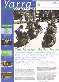 Melbourne Tram Museum
Magazine, Yarra Trams, "Yarra Connections", Dec. 2003
Demonstrates a Yarra Trams staff newsletter..1 - Magazine - 8 pages, full colour, centre stapled, printed on recycled paper, titled "Yarra Connections Issue 12 December 2003", published by Yarra Trams. Notes the launch of the "Wheelchair users guide" for tram passenger, Yarra Trams support for Wheelchair Rugby, planning for Vermont South extension, French award for CEO, Hubert Guyot, photo exhibition featuring employees by Georgia Metaxas, Boroondara residents and Travelsmart, Metlink Team Tigers Basketball, Ikea store in Richmond, pram friendly trams, feedback and return of W class trams to route 30. New track maintenance vehicle -"scrubber truck". .2 - Letter on Yarra Trams letterhead, addressed to Ron Wilson of Orange Grove Bayswater, signed by Paul Matthews Marketing Manager forwarding a copy of the magazine to Ron, noting highlights. Gives address details. .3 - Magazine - as for .1 - issue 1 dated October 1999 with a forward by the CEO Steve Macdonald , Camberwell depot, Deputy CEO Hubert Guyot, new logo designs, reduction in tram stops, tennis trams, family day, Docklands route 70 extension and competition. .4 - magazine - 3 fold A4 - issue 9, dated Nov. 2002, Notes the construction of Route 109, W class, St Vincent's Plaza, Gordon Atkins, Docklands tram services, explorer program, Feedback, Line Officers, Corporate Report and Melbourne Museum tram. .5 - magazine - issue 11 - August 2003 - 8 pages - opening of Box Hill line, Harry the Wombat, trams in the press, Welcome to Dennis Cliche, B class seating trial, Metlink, Docklands, trial information at tram stops (early TramTracker) project and route 75. .6 - magazine issue 13 - April 2004 - Australian Open tram service, Collins and Spencer Superstop, tram services, feedback, Metlink, Channel 10 - The Secret life of us, PTC Cricket Squad. .7 - issue 8 - April 2002 - Grand Prix, Box Hill update, Citadis update, Collins and Spring superstop, Australia Open, Fare Evastion and track joints.trams, tramways, yarra trams, w class, disability services, vermont south, awards, metlink, route 30, camberwell depot, docklands, route 70, st vincent's plaza, line officers, box hill, route 109, b class, superstops, cricket, tennis, tramtracker, route 75 -
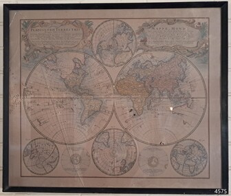 Flagstaff Hill Maritime Museum and Village
Map - World Map, Mappe Monde [Medieval Map of the World], 1910
... with early world explorers. A comparison of maps over the centuries ...This map from the mid-18th century doesn't include the finer details of land and sea masses that we know today. The map was produced by German cartographer and publisher, Johann Baptist Homann (1663-1724) and published in 1746, after his death. Earlier versions were published, such as 1707 and 1716. The date can be calculated from the Roman numerals on the top left text area. This print of a map is significant for its connection with early world explorers. A comparison of maps over the centuries shows the progression of navigational technology, the countries who claimed the land they explored. The naming of even some Australian locations shows who had already made their mark on Australia in the early 18th century. The print shows the fine details included by the cartographer and the beauty included that makes it attractive and interesting even today. The map is also significant for its connection with German cartographer, Johann Baptist Homann, whose Homann publishing company was renewed in Germany for producing high quality maps and atlases. Map behind glass in dark brown wooden frame on beige paper. The Coloured hand drawn line drawings show different hemispheres of the known world in the mid-18th century. Beautifully drawn figures and decorative embellishments enhance the map. The text on the top right has an explanation of the Figures I, II, III, and IV. This print of the 1746 map was produced in England by Leisure Arts Ltd. "PLANIGLOBIL TERRESTRIS" "MDCCXXXXVI" [1746] "MAPPE_MONDE" [Medieval Map of the World] "LEISURE ARTS LTD" "Printed in England"flagstaff hill, warrnambool, flagstaff hill maritime museum, flagstaff hill maritime village, flagstaff hill maritime museum and village, shipwreck coast, world map, french map, 18th century map, leisure arts ltd, cartography, early exploration, cartographer, johann homann (1663-1724), exploration, naviagtion, 1746 planiglobil terrestris