Showing 388 items
matching east entrance
-
 Uniting Church Archives - Synod of Victoria
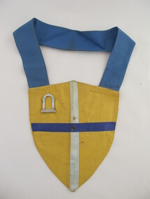
Regalia
Yellow District Court Shield with Blue Collar and Page of the Entrance Symbol.methodist order of knights -
 Lakes Entrance Historical Society
Memorabilia, Old Views of Gippsland, 1999
Cat no 10144.1 dated 2003, Cat no 10144.2 dated 2005, Cat no 10144.3 dated 2006, Cat no 10144.4 dated 2008, Cat no 10144.5 dated 2008, Cat no 10144.6 dated 2006, Cat no 10144.7 dated 19997 Calendars of various views of Gippslanddocuments, calendars -
Lakes Entrance Historical Society
Memorabilia, Early Farming Scenes of East Gippsland, 1985
Calendar issued as part of Victorian 150th Anniversary celebrations1986 Calendar, beige coloured plastic cover with white spiral bound plastic spine, photo on front cover is of Bullock Team carting a wagon with wool balesdocuments, calendars -
Lakes Entrance Historical Society
Book, East Gippsland National Estate Report, 1996
109 printed pages, plastic envelope containing maps inside rear cover, spiral wire boundBuff coloured cover with leaf pattern, left side of cover is brown, rear cover is monotone buff.documents, reports -
Lakes Entrance Historical Society
Administrative Record - Documents, Community Heritage Plan Steering Committee, 1992
White two ring binder containing various documentation relating to East Gippsland Heritage Plan, 1992 to 1999books correspondence -
Lakes Entrance Historical Society
Book, Land Conservation Council Victoria, The Gippsland Lakes Land Use Strategy Plan 1978, 1985
A review of public land use in the East Gippsland area, including natural resources, flora and fauna, recreation. Contains photographs, maps statistics.conservation, aboriginals, primary industry -
Lakes Entrance Historical Society
Book, Vantree Pty Ltd Shearwater Environmetal Management, East Gippsland - Creating a Community Heritage Plan, 2002
This plan provides for the long-term Coastal Action Planwaterways, environment, tourism, boats and boating -
Lakes Entrance Historical Society
Book, Rule, Hilda, East Gippsland Past and Present, 1980
History of Nowa Now for the 'Back to Nowa Nowa' in September 1980. Includes photographs.township, timber industry, settlement -
 Whitehorse Historical Society Inc.
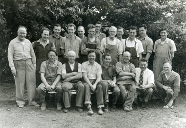
Photograph, Staff Swifts Foundry
Joe Swift made and donated the following items to the Mitcham Sub-Branch of the RSL.|1. RSL Badge outside the entrance doors from the main car park.|2. Legacy Badge inside the above doors.|3. Sword mounted on the East wall of the main hall.|It is thought that Swift's Foundry manufactured some items for Canberra War Museum and the above may have been replicas.Black and white photo of Staff at Swifts Foundry, Carween Avenue, Mitcham. Swifts made Commemorative Plaque for opening of Schwerkolt Cottage.swifts foundry, carween avenue, mitcham, cook, molly -
 Whitehorse Historical Society Inc.
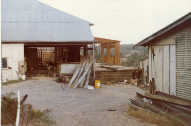
Photograph, Livermore's Orchard
Coloured photo of east into cool store and packing shed entrance on Livermore's Orchard, Morack Road, Vermontlivermores orchard, morack road, vermont, livermore, clem, orchards -
 Whitehorse Historical Society Inc.
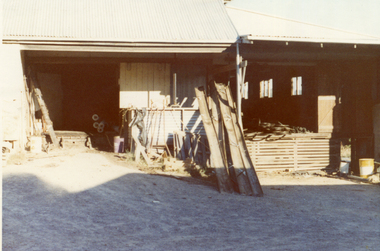
Photograph, Livermore's Orchard
Coloured photo looking east into cool store and packing shed entrance on Livermore's Orchard, Morack road, Vermontlivermores orchard, morack road, vermont, livermore, clem, orchards -
 Whitehorse Historical Society Inc.
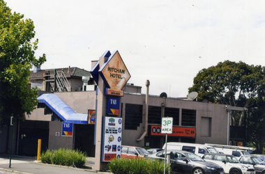
Photograph, Mitcham Hotel
Coloured photograph of the Mitcham Hotel, situated on the south -east corner of Mitcham and Whitehorse Roads, Mitcham. The cars are in the hotel carpark at the rear of the building. The main entrance is on Whitehorse Road - 2012mitcham hotel, hotels -
 Whitehorse Historical Society Inc.
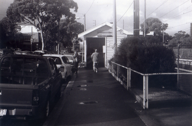
Photograph, Looking to Booking Office on North side of Nunawading Station, 1/06/2009
One of a collection of photographs taken of the Nunawading Railway Station prior to the lowering of the railway line and building of the new railway station on the western side of Springvale Road so that the Springvale Road Rail Crossing can be eliminated.Black & white photograph of he precinct surrounding the Nunawading Station and the Springvale Road Railway crossing. This photograph is the entrance to the Booking Office for trains from Nunawading travelling east. See NP 3545 to NP3567 for the complete set of photographsnunawading railway station, springvale road nunawading, redevelopment of railway line/springvale road. -
 City of Ballarat Libraries
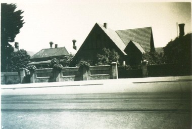
Photograph, 1319 Sturt Street
1319 Sturt Street was built in 1928 for Dr. S.A. Wilson. It was a double brick residence with diagonal leadlight windows. Margaret Wilson and her mother can be seen in the second photo. In the third photo, Margaret by the tradesman's entrance in the garden. Along with 1321 Sturt Street, the house was demolished in 1962 and a Shell Service Station was built.building, private residence, s.a. wilson, margaret wilson, sturt street, ballarat, garden -
 City of Ballarat Libraries
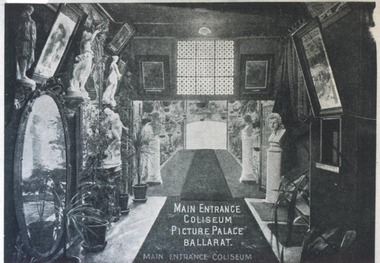
Photograph, Main entrance Coliseum Picture Palace circa 1915
The Coliseum Picture Palace was located in the Grenville - Little Bridge Street area. building, public, coliseum picture palace, entertainment, cinema, ballarat, interior -
 City of Ballarat Libraries
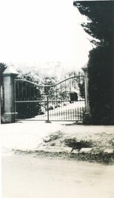
Photograph - Card Box Photographs, Entrance gates to 'Raasay', Ballarat circa 1905
raasay, ballarat, building -
 City of Ballarat Libraries
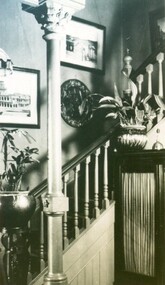
Photograph - Card Box Photographs, Possibly the Entrance Hall at 'Raasay', Ballarat circa 1905
raasay, ballarat, building, private dwelling, staircase, interior -
 Ballarat Heritage Services
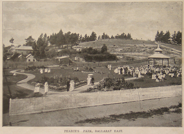
Photograph - Image - Black and White, Pearce's Park, Ballarat East, 1915, 1915
Pearce's Park is situated on the corner of Barkly and Gladstone Streets, Mount Pleasant (although it is sometimes described as being in Golden Point and Ballarat East). Isaiah Pearce was an owner of a goldmine and mayor. He built Clowance House in Barkly Street and chose not to build around Lake Wendouree as he thought it was snobbish. Since Pearce's death, the home has been a maternity hospital and a women’s boarding house. It includes a marble-effect entrance, fireplaces, ceilings and cornices. Photograph of Pearce's Park in Mount Pleasant.ballarat east, pearce's park, mount pleasant -
 Lakes Entrance Historical Society
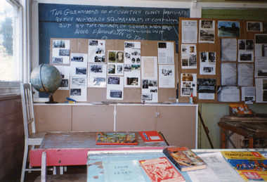
Photograph, 1995
Wairewa State School no 3739, opened 1923, closed 1973.Colour photograph of the inside of the Wairewa State School, East Gippslandschools -
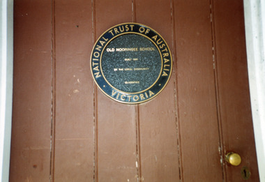 Lakes Entrance Historical Society
Photograph, 2000
Colour photograph of the old Noorinbee State School no. 3372, National sign on school door East Gippsland Victoriaschools -
 Lakes Entrance Historical Society
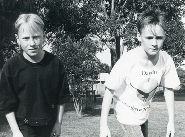
Photograph, Lakes Post Newspaper, 1990
Students identified as Naomi Ellis and Jason McCooey.Black and white photograph of two students of Lakes Entrance Primary School chosen to represent East Gippsland in Victorian State Schools Cross Country Championships at Bundoora. Victoriaschools, students -
Lakes Entrance Historical Society
Flyer - 25 Tourism brochures
postpak mailing box containing 25 tourism brochures for East Gippsland 1994-2009documents, pamphlets -
 Southern Sherbrooke Historical Society Inc.
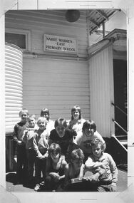
Photograph - Last day of school before its closure, December 1987
Black and white photo ten students at Narre Warren East School on its last day before closing permanently in December 1987. The children are sitting and standing in front of the school building which has a sign on its wall reading "NARRE WARREN/EAST/PRIMARY SCHOOL". An outside light is on the wall above the sign. On the right is a short flight of steps to the classroom entrance and on the left is a water tank. Photo copied from Edna Boothroyd whose family lived next door to the school. -
 Ballarat Tramway Museum
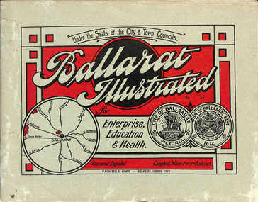
Book, "Ballarat Illustrated", 1972
Original c 1914 (see below), facsimile copy - re-published 1972. Original features photos of Ballarat City and Town, its buildings, parks and the various industries and organisations that were in Ballarat at the time of publication, including ESCo. Many photos features ESCo trams. Photos sepia toned. Has some red colour block printing on the front cover and rear, for Star Oil Engines. On inside back cover is a map with the places of interest and tram route map, marked in red. Pages are un-numbered. Original published by Ballarat East Town Council and Ballaarat City Council. On cover has number stamped in black in, "No. 87" (assume facsimile copy No.). Photos with publication show tram No. 21, built 1913 and ESCo photo page shows Mr. Pringle as Manager. Mr Pringle became manager in January 1911, As there is no photos of the "Avenue of Honour", or other mention of the first world war, assume original published about 1913 or 1914. Original shows Engravings and printing by "Campbell Wilson Prop Ltd, Ballarat". See Other Information as well for more listing details. High Resolution image added 31/8/2012 of i2 of ESCo page and i3 for Ballarat identies and sheet i4 extracted for Mr Pringle. PDF scan of full document added 21/5/2019 - see images btm633-1i.pdf and btm633-2i.pdf Notes on "Ballarat Illustrated" Reg. Item No. 733 From notes made by Neville Gower 12/1/1997 Cover: Inside front cover: Last paragraph, "Facilities for Travelling" - Electric trams serve all parts of Ballarat. Page 3: Street Scene, Municipal Town Hall, showing tram wiring Page 7: Street Scene, Lydiard St. North, intersection and tramway centre, with ESCo tram No. 21 in the bottom photo. Other photos features trams as well in Sturt St and Lydiard St. North. Page 9: Street Scene, Top photo of Sturt St. from Lydiard St. looking east, shows piles on right-hand side of road. Car parked by Post Office has a car registration number "9007". Bottom photo, an tram climbing hill, shows double trolley in the street, with early English type of pull offs. Page 13: Street Scenes and Historic Buildings: One of five photos, shows Victoria St. looking East, with tram track prominent in photo and how stone work was set up about the rails and overhead poles. Page 23: Street scene, Gardens North Entrance gates, shows details of gates near St. Aidans Drive. Note double trolley wire on poles, and style of insulators. No trams in photo, three ladies walking down the track. Page 37: Street Scene; Lydiard St views, top left hand photo, shows Railway station and railway gates with signal gantry and horse drawn vehicles. Tram tracks apparent. Bottom left hand photo shows Lydiard St. North, near Post Office, double track with centre poles - Single wire per track. Top right hand photo, showing Cemetery gates in background. Bottom right hand photo - from north end of Lydiard St. South, looking north, with an ESCo tram in background. Also has a parked car on left hand side. Page 45: Street Scenes - Bridge St; top photo at west end of Bridge St. with ESCo No. 11 with possibly double trolley wire in photo. Bottom photo at east end of Bridge St. with tram in background, shows junction. Double trolley heading out to Mt. Pleasant, single trolley for Victoria St. Page 45: Street Scenes - Bridge St; top photo at west end of Bridge St. with ESCo No. 11 with possibly double trolley wire in photo. Bottom photo at east end of Bridge St. with tram in background, shows junction. Double trolley heading out to Mt. Pleasant, single trolley for Victoria St. Page 61: Street Scenes and Historic Buildings - Public Institutions Ballarat - top left hand photo of the Hospital shows some tram track in foreground, with double trolley wire. Top right photo is of the Orphanage, the name of the tram terminus for many years. Page 68: Electric Supply Co. of Victoria's pages - top photo showing powerhouse in background, across the lake, can hardly see anything for the trees, except for the chimney. Bottom photos of the steam Turbo Generators and the switchboard. Gives Mr. P.J. Pringle as Chief Engineer and General Manager. He took over in Jan. 1911. Page 69: Ballarat East Views - features photo of Black Hill open cut, Ballarat East Railway Station, Ballarat Fire Station and "Victoria St. looking East", repeat of photo printed on page 12, but slightly darker. Image on system includes fire station and railway station, - Ballarat East. Page 78: Series of photos of various Ballarat VIP's of the era, fourth one in on top line features "P.J.Pringle, Electric Supply Co." Inside Back cover - map of Ballarat including tram lines and places of interest marked in red. Gives a detailed photographic presentation of Ballarat in 1914.80 page book with, in addition, light green card covers, titled "Ballarat Illustrated". Loose copy of page 9 and 10 held.trams, tramways, ballarat, local history, heritage buildings, esco -
 Bendigo Historical Society Inc.
Document - MYSTERY OF JOHN MCMAHON'S GRAVE BIG HILL
... Tunnel entrance, Melbourne side/east of line (photos taken March... McMahon, 850 metres south of Big Hill Tunnel entrance, Melbourne ...The Mystery of John McMahon's Grave, Big Hill mentions granite stone markers south of the Tunnel. Some believed he was buried there, but further research has found he is buried at the Kangaroo Flat Cemetery in the Roman Catholic section, Grave No. 1134 on 20 May, 1874. Also mentioned is his widow was appointed Gate Keeper at Ravenswood on 2 September, 1874. Also mentioned is the death of Frederick Benton, who died on 24 February, 1860 of peritonitis. There is a sepia? Photo taken of the Big Hill Tunnel (Bendigo side looking south) from Picture Australia c. 1875 and a coloured one of the Big Hill Tunnel Bendigo side (photo taken March, 2008). On page 2 are two coloured views at Big Hill for John McMahon, 850 metres south of Big Hill Tunnel entrance, Melbourne side/east of line (photos taken March, 2008).person, individual, john mcmahon, mystery of john mcmahon's grave, big hill, john mcmahon, big hill tunnel, mrs i marchesi, mr marchesi, mrs ivy irene marchesi (nee bone), sarah mcmahon, sarah mcewan (mckeown/mckeon), ravenswood station, kangaroo flat cemetery, sarah jane mcmahon, frederick benton, pictureaustralia, vic rail, melbourne to mount alexander-murray rail line, stone markers for john mcmahon -
 Buninyong & District Historical Society
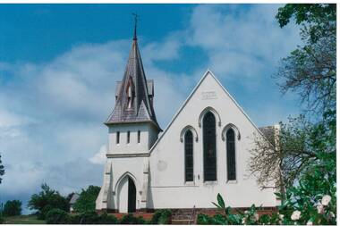
Photograph - Original Photograph, Clive Brooks, Buninyong Uniting Church (1860, formerly Presbyterian) Learmonth St. front view from east, 9 Nov. 1991
detail of historic buildingBuninyong Uniting Church (1860, formerly Presbyterian) Learmonth St. front view from east, showing steeple and gothic arched windows and entrance.buninyong, church, presbyterian, uniting, learmonth st. -
 Kew Historical Society Inc
Photograph - 8 roomed DF Brick Villa, Kew, J E Barnes, c.1920
Subdivision plans are historically important documents used as evidence of the growth of suburbs in Australia. They frequently provide information about when the land was sold on which a built structure was subsequently constructed as well as evidence relating to surveyors and real estate and financial agents. The numerous subdivision plans in the Kew Historical Society's collection represent working documents, ranging from the initial sketches made in planning a subdivision to printed plans on which auctioneers or agents listed the prices for which individual lots were sold. In a number of cases, the reverse of a subdivision plan in the collection includes a photograph of a house that was also for sale by the agent. These photographs provide significant heritage information relating house design and decoration, fencing and household gardens. The photograph is of additional aesthetic significance as it was photographed by J. E. Barnes. Josiah Earl Barnes is a nationally significant photographer. He was also the most important photographer to have worked in Kew. He was active as a photographer in the district from c.1906 until his death in 1921. Best known as 'the Embarkation Photographer' (see the Australian War Memorial collection), J. Earl Barnes was also the official photographer employed by the Borough (and later Town, then City) of Kew. He clearly also completed commercial jobs for local businesses, as is the case in this photograph of a house for a local real estate and financial agent.A photograph, mounted on board of a double fronted Federation-era brick villa in Kew, photographed for a local real estate agent and financier by J. E. Barnes of Kew. On the reverse of the photograph is a subdivision plan for the Normanby Estate, East Kew - 2016.0039.1. As can be seen from the image, there is a large tear on the surface of the photograph.The brown card on which the photograph is mounted includes the following handwritten description, which may aid the identification of the house: "Kew, 3 minutes from tram, 8 roomed DF Brick Villa, tile roof including two attics, sleepout, bathroom, heater, E Light, Entrance Hall, double doors, leadlights, laundry, garden, lawns, land 75 x 170, 1975 pounds". Also photographers inscription on mount, lower left: J. E. Barnes / Photo / Phone 1966 Haw. KEW.j. e. barnes, josiah earl barnes, j. earl banes - photographer, architecture - federation style, houses - kew, real estate photographs -
 Kew Historical Society Inc
Plan - Subdivision Plan, Jas R Mathers Son & McMillan, Macartney Estate, East Kew, c. 1925
Pru Sanderson, in her groundbreaking ‘City of Kew Urban Conservation Study : Volume 2 - Development History’ (1988), summarised the periods of urban development and subdivisions of land in Kew. The periods that she identified included 1845-1880, 1880-1893, 1893-1921, 1921-1933, 1933-1943, and Post-War Development. These periods were selected as they represented periods of rapid growth or decline in urban development. An obvious starting point for Sanderson’s groupings involved population growth and the associated economic cycles. These cycles also highlighted urban expansion onto land that was predominantly rural, although in other cases it represented the decline and breakup of large estates. A number of the plans in the Kew Historical Society’s collection can also be found in other collections, such as those of the State Library of Victoria and the Boroondara Library Service. A number are however unique to the collection.Subdivision plans are historically important documents used as evidence of the growth of suburbs in Australia. They frequently provide information about when the land was sold on which a built structure was subsequently constructed as well as evidence relating to surveyors and real estate and financial agents. The numerous subdivision plans in the Kew Historical Society's collection represent working documents, ranging from the initial sketches made in planning a subdivision to printed plans on which auctioneers or agents listed the prices for which individual lots were sold. In a number of cases, the reverse of a subdivision plan in the collection includes a photograph of a house that was also for sale by the agent. These photographs provide significant heritage information relating house design and decoration, fencing and household gardens.The Macartney Estate subdivision advertised 21 lots for sale on either side of Macartney Street (now Macartney Avenue) and Evans Road in what was then designated as East Kew. Most of the houses shown on the south side of Macartney Street then, as now, have rear entrances on Mount Street, however a number of these blocks have since been further subdivided to allow for the building of new houses on the rear of a block. Brougham Place is marked on the plan but is now called Daniell Place."C"subdivision plans - east kew, macartney estate, macartney street, mount street, evans road, brougham place -
 Kew Historical Society Inc
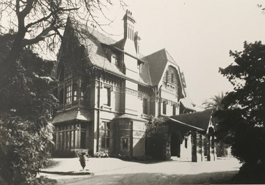
Photograph - 'Tara Hall', Studley Park Road, 1890-1900
During construction, commentators described the house as being in the ‘Elizabethan style’. The architectural style of the exterior, with its innovatory use of red brick and Italian tiles was more influenced by American models. Edward George Kilburn, of Ellerker & Kilburn, designed Byram for the industrialist George Ramsden in 1888.This is an original small photograph of this historic Kew mansion with provenance by descent from the first owners of the house.The main entrance to Tara Hall (previously named Byram, Goathland and Lowan). The entrance, through a porte-cochère, was located on the east side of the house. Inscription reverse: KH-323 Tara Hall once stood on Studley Pk Road on vast landscaped gardens. Donated by Mr Peter Ramsden, 49 Kamilaroy Road, West Pymble 2073 N.S.W. Dec.1979."byram, tara hall, lowan, goathland, edward g. kilburn (architect), george ramsden -
 Kew Historical Society Inc
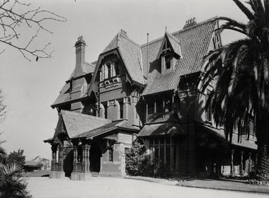
Photograph - Porte-cochere, 'Tara Hall', Studley Park Road, Marc Strizic (attrib), c.1960
'Lost Glories: a memorial to forgotten Australian buildings' was published by David Latta in 1986. It tells the story of a number of significant Australian buildings that had previously been demolished. A chapter in the book was devoted to Goathland, later known as Tara Hall. To supplement the text, he sourced photographs from a range of suppliers, chiefly the Royal Women's Hospital which had once owned Tara Hall, but had sold it in 1960. This is one of the photographs donated to KHS by the author. Porte-cochere, Tara Hall, circa 1957. The main entrance to Tara Hall (previously named Byram, Goathland and Lowan). The entrance, through a porte-cochère, was located on the side of the house facing east. During construction, commentators described the house as being in the ‘Elizabethan style’. The architectural style of the exterior, with its innovatory use of red brick and Italian tiles was more influenced by American models. Edward George Kilburn, of Ellerker & Kilburn, designed Byram for the industrialist George Ramsden in 1888. Typed inscription on reverse: "Goathland, also known as Tara Hall (Royal Women's Hospital, Melbourne)."goathland -- kew (vic), byram -- kew (vic), tara hall - kew (vic), studley park road