Showing 480 items
matching eltham-greensborough road
-
 Greensborough Historical Society
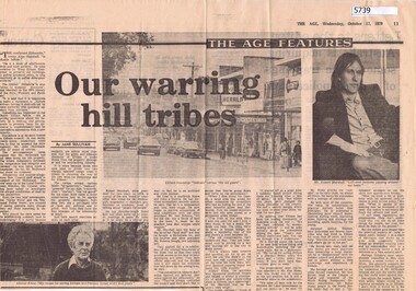
Newspaper Clipping, Jane Sullivan, Our warring hill tribes, by Jane Sullivan, 17/10/1979
Article on Eltham and its council; particularly the clashes in the 1970s, between "conservatives" and "progressives".Newspaper clippingeltham -
 Greensborough Historical Society
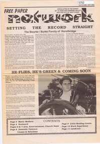
Newspaper, Network Community Newspaper, Network. November 1992, 1992_11
Free newspaper circulating in Eltham, Diamond Valley and Whittlesea. Main article: Setting the record straight: the Bourke/Burke family of Hurstbridge12 p. Black and white text and photographs hurstbridge, burke family, patrick bourke -
 Greensborough Historical Society
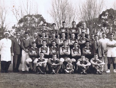
Photograph, Greensborough Football Club, Greensborough Football Club 1961, 1961_
Greensborough Football Club, First Eighteen, Premiers 1961, Diamond Valley League. Names supplied by Gary Partington. Back row, Left to right: Rob Wickes, not known, John Crellin, Don Bell, Ian Bryant; 2nd row from back: Jim Kill, Dick Ward, Arthur Cattach, Ern Bishop, Frank Londrigan, Trevor Partington, Graham Geer, Brian Eltham, Jack Maurer, Tom Tobin, John Ely, Ron Hall; 3rd row from back: Joh Nolan, Rob Wasley, David Wickes, Joe Murphy (Captain/Coach), Len Mullenger, Don Williams; Front row: Fred Anderson, Brian Weidlich, Peter Londrigan (mascot), Trevor Browning, Ron Reynolds. Team photograph of Greensborough Football Club. Not mounted. .greensborough football club, diamond valley league -
 Greensborough Historical Society
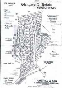
Plan, Coghill and Son, Glengarriff Estate Montmorency, 1938c
Plan for the Glengarriff Estate covers 171 lots in vicinity of Montmorency Railway Station, for private sale, controlling agents Coghill & Son, Local Agents Shallard Bros, Main Road Eltham. C/T 6068/1213512 formerly owned by George Nicholson, dentist.Black and white photocopy of a real estate agent's plan of subdivision montmorency, glengarriff estate montmorency, calrossie street montmorency -
 Greensborough Historical Society
Map, Melbourne and Metropolitan Board of Works. Survey Division, MMBW, Yarra 2500 / 13.19. Lower Plenty, Montmorency, Yallambie, 1979_02
Melbourne and Metropolitan Board of Works. Yarra 2500 [base map] 13-19. Lower Plenty, Montmorency, Yallambie. Parishes of Keelbundora 2856 and Nillumbik 3310. Municipalities of Heidelberg 228, Diamond Valley 257 and Eltham 238. Prominent streets include: Elder Street, Para Road, and Main Road Lower Plenty. Includes Watsonia Army Barracks.MMBW Map in 1:2500 [scale] series. Cream parchment with green tape reinforcing on edges and punched holes on left edge.mmbw, melbourne and metropolitan board of works, shire of diamond valley, montmorency - maps, yallambie - maps, lower plenty - maps -
 Greensborough Historical Society
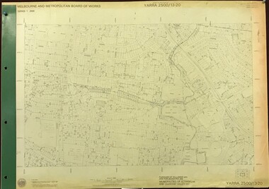
Map, Melbourne and Metropolitan Board of Works. Survey Division, MMBW, Yarra 2500 / 13.20. Greensborough, Montmorency and Watsonia, 1979_03
Melbourne and Metropolitan Board of Works. Yarra 2500 [base map] 13-20. Greensborough, Montmorency and Watsonia. Parishes of Nillumbik 3310 and Keelbundora 2856. Municipalities of Eltham 238 and Diamond Valley 257. Prominent streets include: Nell Street, Nepean Street and Alexandra Street. Includes Montmorency High School.MMBW Map in 1:2500 [scale] series. Cream parchment with green tape reinforcing on edges and punched holes on left edge.mmbw, melbourne and metropolitan board of works, shire of diamond valley, greensborough - maps, montmorency - maps, watsonia - maps -
 Greensborough Historical Society
Map, Melbourne and Metropolitan Board of Works. Survey Division, MMBW, Yarra 2500 / 17.26. Hurstbridge, 1978_01
Melbourne and Metropolitan Board of Works. Yarra 2500 [base map] 17-26. Hurstbridge. Municipalities of Diamond Valley 257 and Eltham 238. Prominent streets include: Flat Rock Road and Heather Avenue. Includes Hurstbridge Railway Station.MMBW Map in 1:2500 [scale] series. Cream parchment with green tape reinforcing on edges and punched holes on left edge.mmbw, melbourne and metropolitan board of works, shire of diamond valley, hurstbridge - maps -
 Greensborough Historical Society
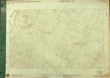
Map, Melbourne and Metropolitan Board of Works. Survey Division, MMBW, Yarra 2500 / 17.25. Hurstbridge, 1978_01
Melbourne and Metropolitan Board of Works. Yarra 2500 [base map] 17-26. Hurstbridge. Municipalities of Diamond Valley 257 and Eltham 238. Prominent streets include: Silvan Road and Hurstbridge Road. MMBW Map in 1:2500 [scale] series. Cream parchment with green tape reinforcing on edges and punched holes on left edge.mmbw, melbourne and metropolitan board of works, shire of diamond valley, hurstbridge - maps -
 Greensborough Historical Society
Map, Melbourne and Metropolitan Board of Works. Survey Division, MMBW, Yarra 2500 / 17.27. Central Hurstbridge, 1978_02
Melbourne and Metropolitan Board of Works. Yarra 2500 [base map] 17-27. Central Hurstbridge. Parish of Greensborough 2724, Municipalities of Diamond Valley 257, Eltham 238 and Whittlesea 239. Prominent streets include: Anzac Avenue and Hurstbridge-Arthurs Creek Road. MMBW Map in 1:2500 [scale] series. Cream parchment with green tape reinforcing on edges and punched holes on left edge.mmbw, melbourne and metropolitan board of works, shire of diamond valley, hurstbridge - maps -
 Greensborough Historical Society
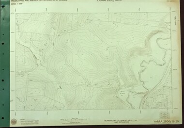
Map, Melbourne and Metropolitan Board of Works. Survey Division, MMBW, Yarra 2500 / 16.25. Wattle Glen, 1978_07
Melbourne and Metropolitan Board of Works. Yarra 2500 [base map] 16-25. Wattle Glen. Municipalities of Diamond Valley 257 and Eltham 238. Prominent streets include: Nimmo Road, Broad Gully Road and Heidelberg-Kinglake Road. Includes Yulong Park.MMBW Map in 1:2500 [scale] series. Cream parchment with green tape reinforcing on edges and punched holes on left edge.mmbw, melbourne and metropolitan board of works, shire of diamond valley, wattle glen - maps -
 Greensborough Historical Society
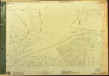
Map, Melbourne and Metropolitan Board of Works. Survey Division, MMBW, Yarra 2500 / 16.24. Northern Diamond Creek and Wattle Glen, 1978_02
Melbourne and Metropolitan Board of Works. Yarra 2500 [base map] 16-24. Northern Diamond Creek and Wattle Glen. Parishes of Nillumbik 3310 and Greensborough 2724. Municipalities of Diamond Valley 257 and Eltham 238. Prominent streets include: Hurstbridge Road, and Reynolds Road. Includes Wattle Glen Station.MMBW Map in 1:2500 [scale] series. Cream parchment with green tape reinforcing on edges and punched holes on left edge.mmbw, melbourne and metropolitan board of works, shire of diamond valley, wattle glen - maps, diamond creek - maps -
 Greensborough Historical Society
Map, Melbourne and Metropolitan Board of Works. Survey Division, MMBW, Yarra 2500 / 16.23. Diamond Creek, 1978_02
Melbourne and Metropolitan Board of Works. Yarra 2500 [base map] 16-23. Diamond Creek. Parish of Nillumbik 3310. Municipalities of Diamond Valley 257 and Eltham 238. Prominent streets include: Phipps Crescent, Bishop Avenue, and Reynolds Road. Includes the former Diamond Creek Technical School.MMBW Map in 1:2500 [scale] series. Cream parchment with green tape reinforcing on edges and punched holes on left edge.mmbw, melbourne and metropolitan board of works, shire of diamond valley, diamond creek - maps -
 Greensborough Historical Society
Map, Melbourne and Metropolitan Board of Works. Survey Division, MMBW, Yarra 2500 / 16.22. Research, 1979_05
Melbourne and Metropolitan Board of Works. Yarra 2500 [base map] 16-22. Research. Parish of Nillumbik 3310. Municipalities of Diamond Valley 257 and Eltham 238. Prominent streets include: Orme Road and Allendale Road. MMBW Map in 1:2500 [scale] series. Cream parchment with green tape reinforcing on edges and punched holes on left edge.mmbw, melbourne and metropolitan board of works, shire of diamond valley, diamond creek - maps -
 Greensborough Historical Society
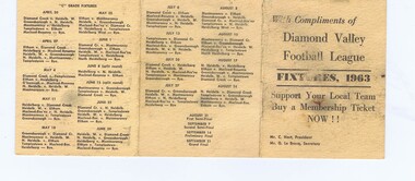
Football Fixture - Digital Image, Greensborough Football Club, Diamond Valley Football League Fixtures 1963, 1963_
Fixture for the Diamond Valley Football League 1963. Note that Greensborough home ground was Warringal and Montmorency home ground was Eltham for this season.Gary Partington is a Life Member of the Greensborough football club and a GHS member. Football fixture, cardboard. Pink card with black text. Tri-fold.greensborough football club, partington family, diamond valley football league -
 Greensborough Historical Society
Newspaper Clipping, Train works steam ahead, 05/06/2019
Rail will be duplicated to Eltham and a major bus interchange created at Greensborough under a $547 million public transport cash splash.News article 1 page, black text.eltham railway duplication, greensborough -
 Greensborough Historical Society
Map, Heidelberg: Historic River Landscape Assessment. Historical maps. Map E 1901-1934 "A Time of projects and improvements", 1985c
Geographical area of around 35 sq. kilometres marked with physical features such as major roads, railways (new extension to Eltham), rivers and properties, also housing sub-divisions and community facilities such as hospitals, parks and sporting reserves and indications of new small scale industries such as dairying. Bounded by Shire of Diamond Valley to the North, Darebin Creek to the West and Plenty River to the East. Black and white sketch map on white paperheidelberg, heidelberg - maps -
 Greensborough Historical Society
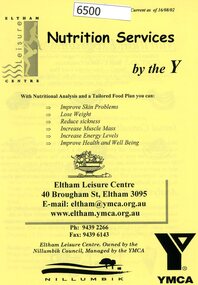
Pamphlet, Nutrition services by the Y. 16/08/2002, 16/08.2002
General information about nutrition services offered by nutritionist Sarina Lococo at Eltham Leisure Centre in 2002.4 page pamphlet, black text on yellow paper.eltham leisure centre -
 Greensborough Historical Society
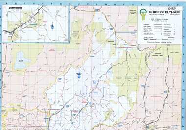
Map, Shire of Eltham, 1990c
1:20000 map of Shire of Eltham, with enlargements of a number of areas.Colour map, printed both sides.shire of eltham, eltham -
 Greensborough Historical Society
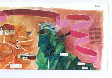
Map, Cultural heritage Map Shire of Eltham, designed and painted by Megan Evans, 1993_
An annotated map of the Shire of Eltham showing places of interestColoured map, folded four times, annotated with historical notes and descriptions of physical and natural featuresshire of eltham -
 Greensborough Historical Society
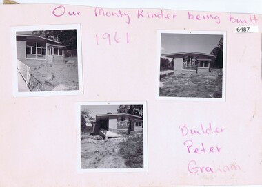
Photographs, Our Monty Kinder being built, 1961_
Photographs of the infant welfare and pre-school centre under construction at Petrie Park Montmorency. Builder Peter Graham.Photos by Peter Graham, former Shire of Eltham councillor.Three black and white photographs mounted on card, with pencilled insciption"Our Monty Kinder being built, 1961" and "Builder Peter Graham" in purple pencilpetrie park montmorency, kindergartens -
![Newspaper Clipping, Leisure Centre starts work on extensions [1991], 1991_05](/media/collectors/4f729f5697f83e03086015b8/items/5d1d703321ea681138a7092c/item-media/5d1dcf3d21ea6b1138166b02/item-fit-380x285.jpg) Greensborough Historical Society
Greensborough Historical SocietyNewspaper Clipping, Leisure Centre starts work on extensions [1991], 1991_05
A leisure and children's fun pool was added to the Eltham Leisure Centre in 1991. Shire President Peter Graham is shown in the photograph.News clipping, text and photograph.eltham leisure centre -
 Greensborough Historical Society
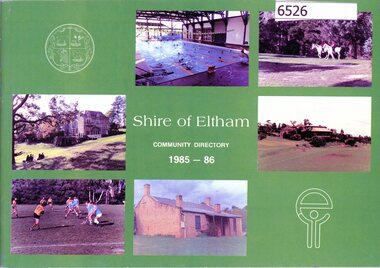
Book, Shire of Eltham Handbook 1985-86, 1985_
The Shire of Eltham was a Local Government Area located about 25 kilometres northeast of Melbourne. The shire covered an area of 277.13 square kilometres and existed from 1856 until 1994.Guide to services provided by Shire of Eltham40 pages, illus. Front cover is a collage of Eltham sceneseltham, shire of eltham, handbooks -
 Greensborough Historical Society
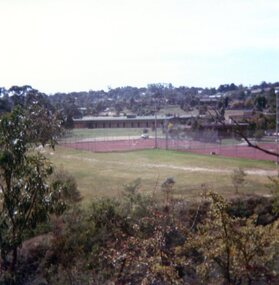
Photographs, Peter Graham, Montmorency Tennis Courts 1979, 17/04/1979
2 photographs of the Montmorency Tennis Courts, taken in 1979 by Peter Graham, a Shire of Eltham Councillor.2 colour photographs.montmorency, tennis, peter graham -
 Greensborough Historical Society
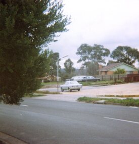
Photograph, Vacant land, Corner Wilson Avenue and Rattray Road Montmorency 1985, 1985_
A photograph of vacant land, Corner Wilson Avenue and Rattray Road Montmorency 1985, taken by Peter Graham, a Shire of Eltham Councillor.1 colour photograph.montmorency, peter graham, rattray road montmorency, wilson avenue montmorency -
 Greensborough Historical Society
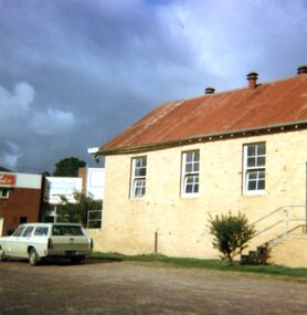
Photographs, Lower Plenty Hall, 1981, 1981_
5 photographs of the exterior of Lower Plenty Hall 1981, taken by Peter Graham, a Shire of Eltham Councillor.5 colour photographs.lower plenty, lower plenty hall, peter graham -
 Greensborough Historical Society
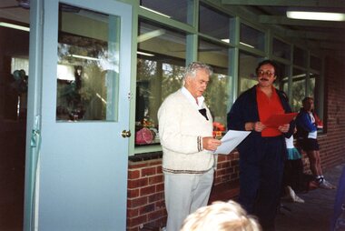
Photographs, Montmorency Tennis Club: opening of extensions, 1992, 17/05/1992
3 photographs of the opening of extensions at Montmorency Tennis Club 1992, taken by Peter Graham, a Shire of Eltham Councillor. Peter is unveiling the plaque, Geoff Bradford also in photos..3 colour photographs.peter graham, montmorency tennis club, montmorency -
 Greensborough Historical Society
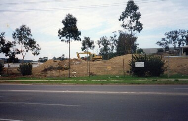
Photographs, Building McDonalds Eltham, 1991, 26/05/1991
3 photographs of the building of McDonalds Eltham 1991, taken by Peter Graham, a Shire of Eltham Councillor. There was some opposition to the opening of this food chain in Eltham.3 colour photographs.peter graham, eltham, mcdonalds eltham -
 Greensborough Historical Society
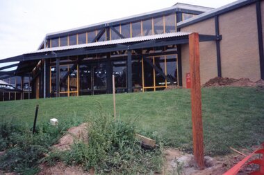
Photographs, Eltham Leisure Centre: re-development, 1991, 26/05/1991
3 photographs of the newly renovated Eltham Leisure Centre 1991, taken by Peter Graham, a Shire of Eltham Councillor. 3 colour photographs.peter graham, eltham, eltham leisure centre -
 Greensborough Historical Society
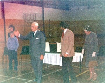
Photographs, Eltham Leisure Centre: opening, July 1980, 1980_07
3 photographs of the opening of Eltham Leisure Centre 1980, taken by Peter Graham, a Shire of Eltham Councillor. People in photos are not identified.3 colour photographs.peter graham, eltham, eltham leisure centre -
 Greensborough Historical Society
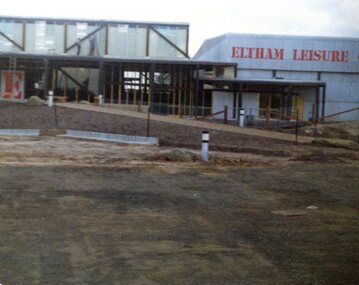
Photographs, Eltham Leisure Centre: nearing completion, May 1980, 1980_05
3 photographs of the nearly completed Eltham Leisure Centre 1980, taken by Peter Graham, a Shire of Eltham Councillor. 3 colour photographs.peter graham, eltham, eltham leisure centre