Showing 260 items
matching eppalock
-
 Uniting Church Archives - Synod of Victoria
Photograph, undated
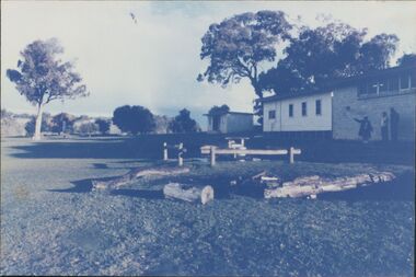
Colour photograph of the outdoor "chapel" space with log seating at the Wesley Point Camp, Lake Eppalock.outdoor chapel, brian walsh, wesley point camp, lake eppalock -
 Bendigo Historical Society Inc.
Pamphlet - Aileen and John Ellison collection: Eppalock dam
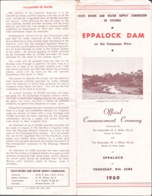
BHS CollectionState Rivers and water Supply Commission of Victoria. Eppalock Dam on the Campaspe River. Official commencement ceremony performed by the Honorable H.E. Bolte MLA Premier of Victoria and the Honorable W.J.Mibus MLA minister of water supply at Eppalock on Thursday, 9th June 1960. lake eppalock, eppalock dam -
 Bendigo Historical Society Inc.
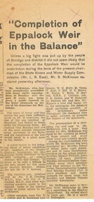
Newspaper - FOSTER AND WILSON COLLECTION: EPPALOCK WEIR
Newspaper article about the building of Eppalock Weir and a farewell to Mr & Mrs S. McKinnon prior to their leaving Bendigo.newspaper, bendigo, s mckinnon, foster & wilson collection, eppalock weir, mr & mrs s mckinnon -
 Bendigo Historical Society Inc.
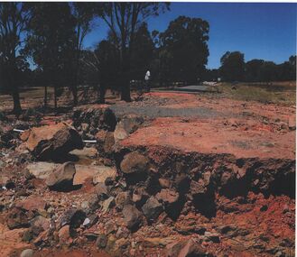
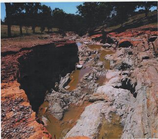
Photograph - HUGH ENNES COLLECTION: EPPALOCK WEIR WATER OVERFLOW - JAN 2011
The Hugh Ennes collection. Colour photograph. Erosion after water overflows from Eppalock Weir, January 2011.state infrastructure, water supply, coliban system -
 Tatura Irrigation & Wartime Camps Museum
Photograph, Goulburn Irrigation System, 1970s
Taken by photographer for State Rivers and Water Supply Commission.Medium sized black and white photograph. Map showing the Goulburn Irrigation System in Northern Victoria including Eildon Reservoir, Waranga Reservoir, Eppalock Reservoir, Eppalock, Cairn Curran, Laancoorie, Tullaroop Reservoirs, the Stuart Murray, Cattanach Canal, East Goulburn Main and Waranga Western Channels.goulburn weir, victorian state rivers and supply commission -
 Bendigo Historical Society Inc.
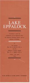
Document - LAKE EPPALOCK - OPENING CEREMONY PROGRAM
Folded document, 5 pages, produced to commemorate the opening of the Eppalock Dam, the Eppalock Pumping Station and the pipeline to Bendigo, by the Premier, Mr. H. Bolte, on 17th April, 1964. Brown cover, cream and black text. Illustrations show the cross section of the tunnel; a plan of the embankments and an overall plan of the weir.bendigo, waterworks, lake eppalock -
 Bendigo Historical Society Inc.
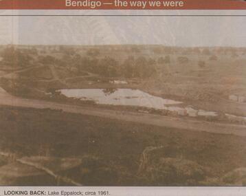
Newspaper - JENNY FOLEY COLLECTION: LOOKING BACK
Bendigo Advertiser ''The way we were'' from 2001. Looking back: Lake Eppalock; circa 1961. The clip is in a folder.newspaper, bendigo advertiser, the way we were -
Bendigo Historical Society Inc.
Map - CAMPBELL COLLECTION: BENDIGO AND DISTRICT MAPS
Map. Lyell, Parishes of Sedgwick, Eppalock and Lyell. Scale 20 chains to 1 inch. (number 348 in map cupboard 1)map, bendigo, agricultural lands -
 Bendigo Historical Society Inc.
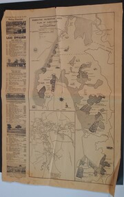
Newspaper - WES HARRY COLLECTION: BENDIGO ADVERTISER NEWSPAPER SAT. 10 AUGUST 1971 ON OPENING LAKE EPPALOCK
Bendigo Advertiser full page article Saturday 10th August 1971 on the opening of Lake Eppalock showing maps of the Lake and attractionsbendigo Advertiser -
 Bendigo Historical Society Inc.
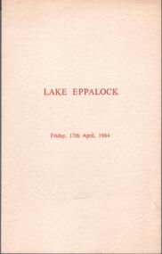
Programme - Aileen and John Ellison collection: Lake Eppalock dam completion
BHS CollectionProgram of the ceremony to mark the completion of the Eppalock dam and pumping station and the Eppalock-Bendigo pipeline. Grifay,17th April 1964. With the programme an invitation from the Chairman and Commissioners of the State Rivers and Water Supply Commission to Mr. John Ellison and Lady to attend the official ceremony to be performed by the Premier of Victoria, the Honorable H.E. Bolte MLAlake eppalock, eppalock dam -
 Bendigo Historical Society Inc.
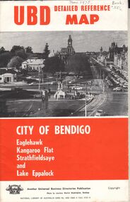
Document - UBD DETAILED REFERENCE MAP - CITY OF BENDIGO
Universal Business Directories Publication UBD Detailed Reference Map - City of Bendigo Eaglehawk, Kangaroo Flat Strathfieldsaye and Lake Eppalock Single page folded map sheet providing three maps: * Bendigo, Eaglehak & Shire of Strathfieldsaye on main sheet * Eppalock & Environs * Kangaroo Flat hand written date June 1975, and 50 cents costUniversal Business Directories Publication -
 Bendigo Historical Society Inc.
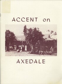
Book - ACCENT ON AXEDALE, 1970
Accent on Axedale. Published by the centenary and back to Axedale Committee. Includes articles on early settlement, hotels, churches, industry, sporting clubs, Eppalock weir.foreword by Ian Smith.axedale, history, back to, axedale, hotel, church, school, back to, history -
 Bendigo Historical Society Inc.
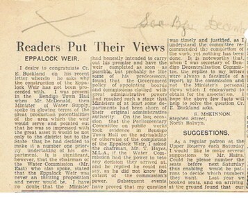
Newspaper - FOSTER AND WILSON COLLECTION: EPPALOCK WEIR
Newspaper cutting entitled 'Readers Put Their Views'. A letter written by S. McKinnon, Stephen Street, North Balwyn, about the building of Eppalock Weir.newspaper, bendigo, s mckinnon, foster & wilson collection, eppalock weir, s. mckinnon -
 Bendigo Historical Society Inc.
Photograph - HUGH ENNES COLLECTION: EPPALOCK WEIR WATER OVERFLOW - JAN 2011
The Hugh Ennes collection. Colour photograph. Erosion after water overflows from Eppalock Weir, January 2011. There are two copies of thios photo.state infrastructure, water supply, coliban system -
 Bendigo Historical Society Inc.
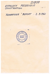
Newspaper - NEWSPAPER ARTICLE: EPPALOCK RESERVOIR CONSTRUCTION ' ADVERTISER ' REPORT 2.9.1961
Aged , partly damaged Newspaper article -Eppalock Reservoir Construction '-The Bendigo Advertiser ' Report 2.9.1961 / photo of excavations prior to commencement of the Dam Wall -/bendigo, newspapers, bendigo advertiser, eppalock reservoir construction -
 Greensborough Historical Society
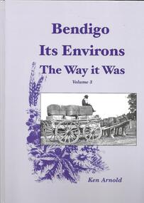
Book, Crown Castleton Publishers, Bendigo Its Environs - the Way it Was. Vol 3 / by Ken Arnold, 2013_
A brief history of the areas of Strathfieldsaye, Junortoun, Longlea, Axedale, Kimbolton, Redesdale, Lyal, Myrtle Creek, Axe Creek, Eppalock, Emu Creek, Sedgwick, Mandurang, Mandurang South and Diamond Hill.399 pages, illus. Hard cover.bendigo -
 Bendigo Historical Society Inc.
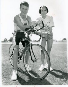
Photograph - BENDIGO ADVERTISER COLLECTION: BIKES, 1994
Photograph - Man on racing bike with woman beside him On Rear: Triathalon at Eppalock Promo Left David Meade, Erica Baldwin 25/3/94recreations, sports, cycling, bendigo advertiser -
 Bendigo Historical Society Inc.
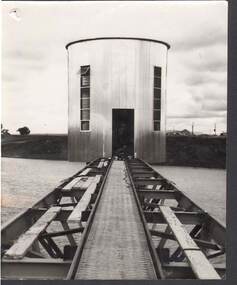
Photograph - MICHELSEN COLLECTION: WATER TOWER
Photograph, Water Tower, under construction, worker near door opening. Houses at right background possibly workers huts, could be at the construction of Eppalock Dam. -
Bendigo Historical Society Inc.
Map - CAMPBELL COLLECTION: BENDIGO AND DISTRICT MAPS
Map. Lyell, Parishes of Sedgwick, Eppalock and Lyell. Scale 20 chains to 1 inch. Total area 3307 acres. (number 387 in map cupboard 1)map, bendigo, country lands -
 Bendigo Historical Society Inc.
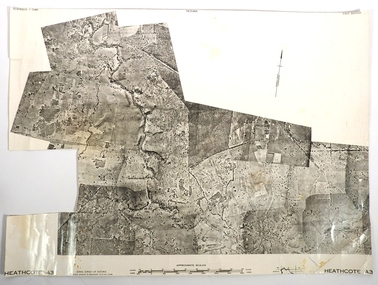
Map - FRED COWIE COLLECTION: AERIAL MAPS OF HEATHCOTE/EPPALOCK
Map, Heathcote A3, Aerial Survey of Victoria, Photo-map prepared by Department of Crown Lands.Campaspe River , Wild Duck Creek, Knowsley, Eppalock Weir.Fred Cowie,46 McIvor Rd ,Bendigo.map, heathcote, fred cowie -
 Bendigo Historical Society Inc.
Document - AULSEBROOK COLLECTION: ARTICLE ON BOAT RACING AND CHAMPIONSHIP AWARDS IN EPPALOCK, 1967
Aulsebrook Collection: Article on boat racing and Championships in Eppalock -History on the Bendigo Power Boat Club -Extensive information on their involvement in a National Inboard Campionships in 1967 with trophy's awarded to winners -One page, typed -
Tatura Irrigation & Wartime Camps Museum
file, State Rivers & Water Supply Commission
This collection was owned by Keith Daniel, an accountant with SR & WSC. Resident in Tatura 6-7 years until 1965File containing - Victorian Government Gazette March 6, 1968. - - Map, Goulburn Irrigation System - Murchison A, SR & WSC Journal "Aqua" April 1966 , Lake Eppalock Boating Guide, "Aqua Summer 1991, Brochure & newspaper adv. re: Waranga Lakeside estate.1974 -
Bendigo Historical Society Inc.
Map - CAMPBELL COLLECTION: BENDIGO & DISTRICT MAPS, 14-6-29
Map. Eppalock, Sedgwick and Strathfieldsaye. Scale 20 chains to 1 inch. Total area 3972 acres. Prepared in W.P.B. from Assessment Plan and Parish Plans. H.A. Darby. (number 378 in map cupboard 1)H.A.Darbymap, bendigo, agricultural lands -
 Bendigo Historical Society Inc.
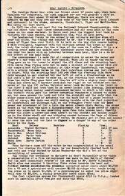
Photograph - BENDIGO ADVERTISER COLLECTION: SIGN POST AT AXEDALE, 16/06/1993
Sign post at Axedale on the McIvor Highway indicating the distance to nearby places. Places named: Bendigo, Heathcote, Longlea, Knowsley, Echuca, Redesdale, Goornong, Twin Rivers, Fosterville, Lake Eppalock, Arakoon Resort, Youth Camp.Bill Hawkingregion, small towns, axedale -
 Bendigo Historical Society Inc.
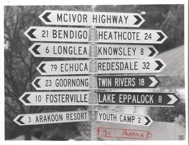
Booklet - 7 Routes in and around Bendigo
A thirty-two pages booklet describing seven tourist routs for sightseeing in and around Bendigo. The routes are: 1) Bendigo. 2) Eppalock. 3) Castlemaine. 4) Maryborough. 5) Kyneton, Daylesford. 6) Wedderburn. 7) Whipstick Hill.On cover in blue pen the name John Hattam. Library sticker on spine 0059JWHbendigo, tourism, guide -
 Bendigo Historical Society Inc.
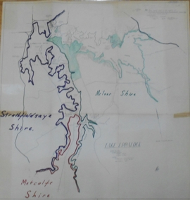
Map - STATE RIVERS AND WATER SUPPLY COMMISSION : LAKE EPPALOCK
State Rivers and Water Supply Commission of Victoria. Coliban System. Lake Eppalock. Map of Lake Eppalock foreshore area. Colour is used to delineate the areas of the Lake included in the three councils - McIvor Shire, Metcalf Shire and Strathfieldsaye Shire. Scale is 1 inch = 40 chains. Various notations in pencil have been added, with 'Coliban Office Plan' written and circled in the top right corner. A coloured (green) area is scaled as 'fore shore area in the charge of Derrinal Recreational Area Management Committee'. Individual leasing details have been added. state infrastructure, water supply, coliban system, state rivers and water supply commission of victoria. coliban system. lake eppalock. -
Bendigo Historical Society Inc.
Map - SEDGWICK : COUNTY OF BENDIGO, 1963
Map. Sedgwick, County of Bendigo, Strathfieldsaye, Eppalock, Lyell, Mandurang, Sutton Grange. By Authority A.C. Brooks, Government Printer, Melbourne. Drawn and reproduced at the Deparment of Lands and Survey, Melbourne. 1963. Price 2/-. (number 7 in map cupboard 1)A.C. Brooks, Government Printer.map, bendigo, sedgwick -
 Bendigo Historical Society Inc.
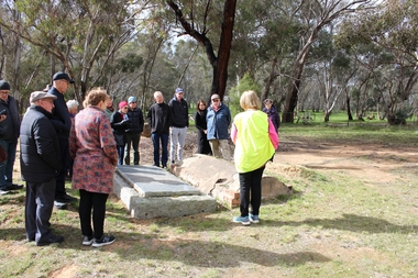
Bendigo Historical Society Walking Tour of Axedale, 1st Sept 2024
Axedale is a town in Victoria, Australia. It is located on the McIvor Highway, in the City of Greater Bendigo, east of Bendigo. It was surveyed and proclaimed in 1861. At the 2021 census, Axedale had a population of 984. The town is nestled alongside the Campaspe River which feeds out of Lake Eppalock. It has a golf course, tennis courts, a school, a pub and a convenience store/petrol station. It lies between Heathcote and Bendigo.Forty Photos taken on the walking tour of Axedale by the Bendigo Historical society. Places visited included the Protestant and Catholic Cemeteries, the "Blue Stone House", the 150-year-old bridge over the Axe Creek on the Sugerloaf Road, the old Cobb and Co Stables, St Andrews Church and the Campaspe River Bridge.axedale, bendigo historical society walking tour, st andrews church axedale, axedale cemetery, axe creek bridge, campaspe, cobb and co stables axedale, blue stone house axedale -
Bendigo Historical Society Inc.
Map - CAMPBELL COLLECTION: BENDIGO AND DISTRICT MAPS
Map. Longlea, Parishes of Eppalock and Axedale. Scale 20 chains to 1 inch. Total area of map 2372 acres, with Bendigo 9 1/2 miles away. H.A. Darby 18-6-29. (number 349 in map cupboard 1)H.A Darbymap, bendigo, allotments -
Bendigo Historical Society Inc.
Map - LYELL : COUNTY OF BENDIGO, 24-10-84
Map. Lyell, County of Bendigo, Eppalock, Sedgwick, Sutton Grange, Hawkestone, Kimbolton, Coliban River, Myrtle Creek. State School. Photo-Lithographed at the Department of Lands and Survey, Melbourne by J. Noune, 24-10-84. (number 71 in map cupboard 1)J. Nounemap, bendigo, lyell