Showing 4193 items matching "greensborough road greensborough"
-
 Greensborough Historical Society
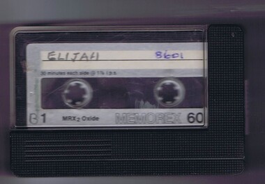
Audio - Audio Cassette, Diamond Valley Choral Society, Elijah, performed by Diamond Valley Choral Society, 1977
... Greensborough Historical Society 34A Glenauburn Road Lower ...A recording of 'Elijah', an oratorio by Felix Mendelssohn, first performed in 1846, depicting events in the life of the Prophet Elijah as told in the Old Testament book of Kings. The work is scored for eight vocal soloists (two each of bass, tenor, alto and soprano). This performance by the Diamond Valley Choral Society was recorded at Greensborough Uniting Church in 1977; conducted by V. Lennie.1 audio cassette in clear plastic caseHandwritten on side 2: "Elijah. DVC Society Cond. V. Lennie. 1977"diamond valley choral society, elijah (oratorio), greensborough uniting church, val lennie -
 Greensborough Historical Society
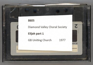
Audio - Audio Cassette, Diamond Valley Choral Society, Elijah Part 1, performed by Diamond Valley Choral Society, 1977
... Greensborough Historical Society 34A Glenauburn Road Lower ...A recording of 'Elijah', an oratorio by Felix Mendelssohn, first performed in 1846, depicting events in the life of the Prophet Elijah as told in the Old Testament book of Kings. The work is scored for eight vocal soloists (two each of bass, tenor, alto and soprano). This performance by the Diamond Valley Choral Society was recorded at Greensborough Uniting Church in 1977; conducted by V. Lennie.1 audio cassette in clear plastic caseHandwritten on side 1: "Elijah. DVCS. G'bro Uniting Church"diamond valley choral society, elijah (oratorio), greensborough uniting church, val lennie -
 Greensborough Historical Society
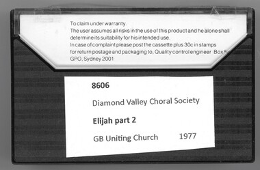
Audio - Audio Cassette, Diamond Valley Choral Society, Elijah Part 2, performed by Diamond Valley Choral Society, 1977
... Greensborough Historical Society 34A Glenauburn Road Lower ...A recording of 'Elijah', an oratorio by Felix Mendelssohn, first performed in 1846, depicting events in the life of the Prophet Elijah as told in the Old Testament book of Kings. The work is scored for eight vocal soloists (two each of bass, tenor, alto and soprano). This performance by the Diamond Valley Choral Society was recorded at Greensborough Uniting Church in 1977; conducted by V. Lennie.1 audio cassette in clear plastic caseHandwritten on side 2: "Elijah. DV Choral Society. Cond. Valda Lennie 1977"diamond valley choral society, elijah (oratorio), greensborough uniting church, val lennie -
 Greensborough Historical Society
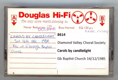
Audio - Audio Cassette, Diamond Valley Choral Society, Carols by candlelight 1986, performed by Diamond Valley Choral Society, 14/12/1986
... Greensborough Historical Society 34A Glenauburn Road Lower ...A recording of Carols by Candlelight. This performance by the Diamond Valley Choral Society was recorded at Greensborough Baptist Church on 14/12/1986.1 audio cassette in clear plastic caseHandwritten on cassette: "Carols by candlelight Sat 14/12/86"; stamped on insert; "Recorded at Twintracks Studios, Greensborough".diamond valley choral society, carols by candlelight, greensborough baptist church, christmas music -
 Greensborough Historical Society
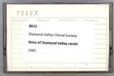
Audio - Audio Cassette, Diamond Valley Choral Society, Shire of Diamond Valley Carols 1988, performed by Diamond Valley Choral Society, 1988
... Greensborough Historical Society 34A Glenauburn Road Lower ...A recording of Shire of Diamond Valley Carols. This performance by the Diamond Valley Choral Society was recorded in Greensborough in 1988.2 audio cassettes in clear plastic casesHandwritten on cassette: "DV Shire Carols '88".diamond valley choral society, carols by candlelight, christmas music, shire of diamond valley -
 Greensborough Historical Society
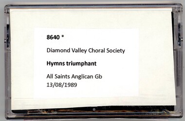
Audio - Audio Cassette, Diamond Valley Choral Society, Hymns Triumphant, performed by Diamond Valley Choral Society 1989, 13/08/1989
... Greensborough Historical Society 34A Glenauburn Road Lower ...A recording of Hymns Triumphant, a collection of hymns originally recorded by the London Philharmonic Choir and Orchestra. This performance is by the Diamond Valley Choral Society at All Saints Anglican Church Greensborough on 13/08/1989.1 audio cassette in clear plastic caseHandwritten on cassette: "Hymns Triumphant"; on insert: "Hymns Triumphant: sung by DVCS with orchestra at All Saints Anglican Church Greensborough. Sunday 13th August 1989 at 7.30pm"diamond valley choral society, hymns, all saints anglican church greensborough -
 Greensborough Historical Society
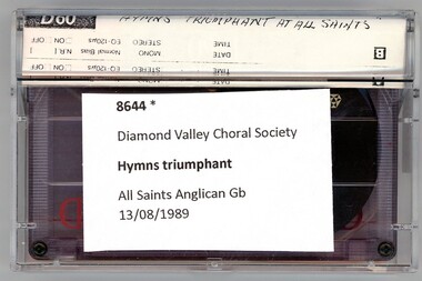
Audio - Audio Cassette, Diamond Valley Choral Society, Hymns Triumphant, performed by Diamond Valley Choral Society 1989, 13/08/1989
... Greensborough Historical Society 34A Glenauburn Road Lower ...A recording of Hymns Triumphant, a collection of hymns originally recorded by the London Philharmonic Choir and Orchestra. This performance is by the Diamond Valley Choral Society and orchestra at All Saints Anglican Church Greensborough on 13/08/1989.1 audio cassette in clear plastic caseHandwritten on cassette: "Hymns Triumphant"; on insert: "Hymns Triumphant: sung by DVCS with orchestra at All Saints Anglican Church Greensborough. Sunday 13th August 1989 at 7.30pm"diamond valley choral society, hymns, all saints anglican church greensborough -
 Greensborough Historical Society
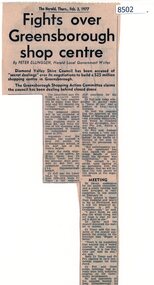
Article - Newspaper Clipping, The Herald, Fights over Greensborough shop centre, 03/02/1977
... Greensborough Historical Society 34A Glenauburn Road Lower ...This article covers some of the issues when the development of Greensborough Plaza was in the planning stages in 1977.Shows local resistance to the building of a large shopping complex in Greensborough.News article, black textgreensborough plaza, shire of diamond valley, bob fell -
 Greensborough Historical Society
Card - Christmas Card, Kate Thwaites, Christmas card from Vicki Ward, State member for Eltham 2023, 2023
... Greensborough Historical Society 34A Glenauburn Road Lower ...Annual greeting card issued by the state member for Eltham Vicki Ward. This card is distributed to homes in the electorate. Illustration by a student from Greenhills Primary School, Greensborough.Card, printed in colour.christmas cards, eltham, vicki ward -
 Greensborough Historical Society
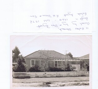
Photograph - Photograph (copy), 11 Ester Street Greensborough, 1972
... Greensborough Historical Society 34A Glenauburn Road Lower ...11 Ester Street Greensborough was owned by Ivy and Des Bryant. Bought in 1964 and sold 1972. Estate agent R.H .Dean and Son. The land has since been subdivided and units built.Copy of black and white photographCaption written on copybryant family, ester street greensborough -
 Greensborough Historical Society
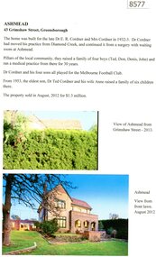
Article, Marilyn Smith, Ashmead: 43 Grimshaw Street Greensborough, 2023
... Greensborough Historical Society 34A Glenauburn Road Lower ...This house was built for Doctor Ted Cordner and family in the early 1930s. Doctor Cordner ran his medical practice from his home. The property was sold in 2012.2p., text and col. imagesgrimshaw street greensborough, ashmead, cordner family -
 Greensborough Historical Society
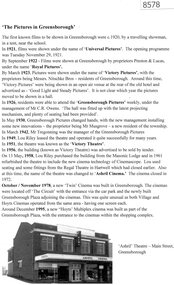
Article, 'The Pictures' in Greensborough, 2023
... Greensborough Historical Society 34A Glenauburn Road Lower ...A short history of cinemas operating in Greensborough 1920s to 1970s. This is an excerpt from an earlier article by Dawn Bennetts.1 page, black and white text and imagecinemas, ashril theatre, greensborough picture theatres -
 Greensborough Historical Society
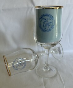
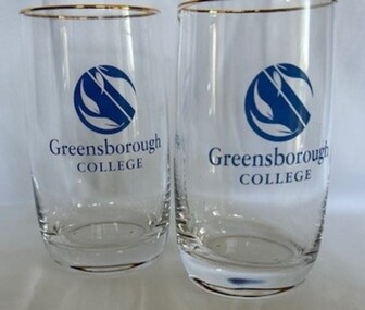
Domestic object - Glasses, Greensborough Secondary College, Greensborough Secondary College glasses, 1990s
... Greensborough Historical Society 34A Glenauburn Road Lower ...A limited number of these glasses would have been presented. Pair of clear stemmed wine glasses, with gold rim. Printed in blue with 'Greensborough Secondary College' and emblem of gum tree branch.greensborough secondary college, glasses, commemorative items -
 Greensborough Historical Society
Domestic object - Glass, Greensborough College, Greensborough College glasses, 1990s
... Greensborough Historical Society 34A Glenauburn Road Lower ...Presented to graduating students.A limited number of these glasses would have been presented. Pair of clear glass water glasses, with gold rim.Printed in blue with 'Greensborough College' and emblem of gum leavesgreensborough college, commemorative glasses -
 Greensborough Historical Society
Article - Interview, Peter Simmenauer, Harold Connell, 24/05/2023
... Greensborough Historical Society 34A Glenauburn Road Lower ...Interview with Harold Connell, on 24 May 2023 at his home in Vermont Parade Greensborough. Interviewer Peter Simmenauer.3 p., typescriptharold connell, connell family -
 Greensborough Historical Society
Map, John Monash, 1913 Map of Greensborough, 1913
... Greensborough Historical Society 34A Glenauburn Road Lower ...1913 Map of Greensborough, possibly by John Monash. This map shows the area to the north of the township.Map, colour.greensborough - maps, 1913 -
 Greensborough Historical Society
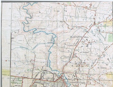
Document - Genealogical Document, June Hall - notes by Norm Colvin, Skals Family, 2011
... Greensborough Historical Society 34A Glenauburn Road Lower ...Family tree of the Skals family of Greensborough, tracing their origins to Denmark. The handwritten note states that the family farm was on Flintoff Hill, north side of today's Civic Drive.1 page PaperPencil additionsflintoff hill, skals family -
 Greensborough Historical Society
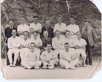
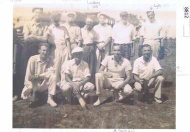
Photograph, Greensborough Cricket Club, 1950s
... Greensborough Historical Society 34A Glenauburn Road Lower ...Photograph of Greensborough Cricket Club with names supplied by Betty McKenzie, Leigh Cameron and Gary Partington. Front row seated left: ? Kerison (with glasses), unknown, Maurie O'Connor; Middle row: L to R: Frank Smith, Lindsay Hall, Wally Butterworth, Alf Montford, Lyle Hall, Doug Hall; Back row: unknown (in suit), Arthur Franklin, Charlie Cook, unknown (in suit), Don Franklin, unknown, Mr Franklin (umpire).Original Photograph and copy of Photograph with namesgreensborough cricket club -
 Greensborough Historical Society
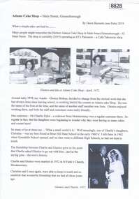
Article, Dawn Bennetts, Adams Cake Shop - Main Street Greensborough, 2019
... Greensborough Historical Society 34A Glenauburn Road Lower ...A short story about Adams Cake Shop in Main Street Greensborough in the 1970s and some coincidences about a member of staff.Article, 1 p., illus.adams cake shop greensborough, glenice dyke, dawn petts, dawn bennetts -
 Greensborough Historical Society
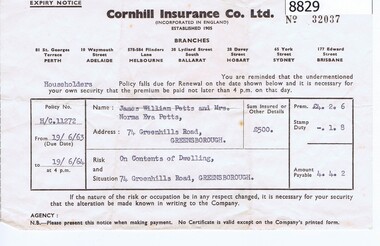
Financial record - Account, Cornhill Insurance Co Ltd, 1963
... greenhill road greensborough...Greensborough Historical Society 34A Glenauburn Road Lower ...Cornhiill Insurance Co Ltd Cert no 32037 Householder Policy 1906/1963 - Greenhill Rd GreensboroughSingle sheet of paper typedTyped details on printed forminsurance, greenhill road greensborough, petts family -
 Greensborough Historical Society
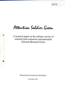
Article, Ian Bryant, Attention Soldier Green, 2023_11
... Greensborough Historical Society 34A Glenauburn Road Lower ...A research paper on the military history of Edward Bernard Green, produced by Ian Bryant. The article is supported by copies of Green's military records.Background history of the man after whom Greensborough was named.20 p., typescript and copies of documents, in plastic folder.edward bernard green, edward bernard drury green, greensborough -
 Greensborough Historical Society
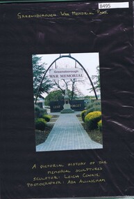
Photograph - Folder of photographs, Ada Allingham, Greensborough War Memorial Park: photos by Ada Allingham, 2003
... Greensborough Historical Society 34A Glenauburn Road Lower ...Photographs by Ada Allingham taken during the carving of original chainsaw statues at Greensborough War Memorial Park. Statues carved by Leigh Conkie in 2003. Some newspaper reports are also included. Of particular interest are the photographs of chainsaw artist Leigh Conkie working on his artworks.Plastic folder with 20 pages of colour photographs mounted on black card with gold pen captions, includes newspaper clippings.greensborough war memorial park, leigh conkie, chainsaw sculptures, ada allingham -
 Greensborough Historical Society
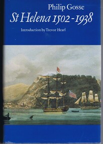
Book, Philip Gosse, St Helena 1502-1938 by Philip Gosse, 1990
... Greensborough Historical Society 34A Glenauburn Road Lower ...A history of the island of St Helena in the South Atlantic Ocean.447 p., illus., maps.non-fictionA history of the island of St Helena in the South Atlantic Ocean. -
 Greensborough Historical Society
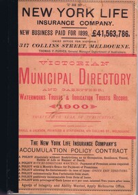
Book - Directory, Arnall and Jackson, Victorian Municipal Directory and Gazetteer 1900, 1900
... Greensborough Historical Society 34A Glenauburn Road Lower ...A compilation of facts and figures of the local government areas in Victoria in 1900.659 p., text.non-fictionA compilation of facts and figures of the local government areas in Victoria in 1900.municipal directories, gazetteers, local government, victoria history -
![Letter - Correspondence - Letter, Bryan Henderson, [Grimshaw Street], 12/11/2022](/media/collectors/4f729f5697f83e03086015b8/items/6602568f792920bfe4defef4/item-media/66067f5c6512b153577249f1/item-fit-380x285.jpg) Greensborough Historical Society
Greensborough Historical SocietyLetter - Correspondence - Letter, Bryan Henderson, [Grimshaw Street], 12/11/2022
... Greensborough Historical Society 34A Glenauburn Road Lower ...Letter to Channel 9 regarding origin of Greensborough street names, with particular reference to Grimshaw Street. Also noted was that the streets mentioned were named after founding members of the Greensborough Wesleyan Church in the mid 1800s.Black and white print, colour photograph, with photocopied extract from "Greensborough Uniting Church's first 150 years" grimshaw street, living faith church, grimshaw family -
 Greensborough Historical Society
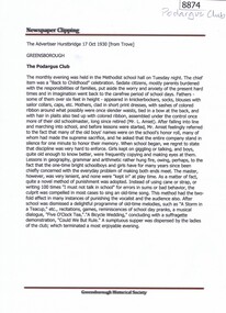
Article - Newspaper Clipping, Advertiser (Hurstbridge), The Podargus Club, 1930_10
... Greensborough Historical Society 34A Glenauburn Road Lower ...The Podargus Club was a social club based in Greensborough, held at the Methodist hall.Two one page articles: 17/10/1930 and 31/10/1930 (sourced from Trove)podargus club, greensborough methodist church -
 Greensborough Historical Society
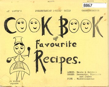
Booklet - Recipe Book, St David's Presbyterian Ladies' Guild Greensborough, Cook book of favourite recipes, 1970s
... Greensborough Historical Society 34A Glenauburn Road Lower ...A cookbook compiled by the Ladies' Guild of St David's Presbyterian Church Greensborough24 p stapled, light card cover.recipes, st david's presbyterian church greensborough -
 Greensborough Historical Society
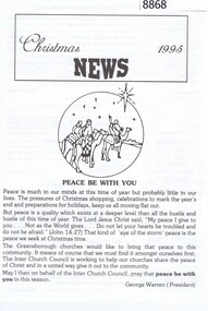
Flyer - Pamphlet, Greensborough Interchurch Council, Christmas News 1995, 1995
... Greensborough Historical Society 34A Glenauburn Road Lower ...Christmas newsletter 1995 from the Greensborough Interchurch Council.4 p. printed on white papergreensborough interchurch council, christmas -
 Greensborough Historical Society
Photograph, Greensborough Cricket Club, 1950s
... Greensborough Historical Society 34A Glenauburn Road Lower ...Casual photograph of Greensborough Cricket Club with names supplied by Betty McKenzie. Front row from left: unknown), unknown, Doug Hall, Ken Waldron; Back row: unknown, unknown Neil Tooth, Lindsay Hall, unknown, unknown, Lyle HAll.Original Photograph and copy of Photograph with namesgreensborough cricket club -
![Photograph - Photograph Collection, Greensborough: Mural on Vickers Way [off Main Street], 2010c](/media/collectors/4f729f5697f83e03086015b8/items/6607af991466534a78efc8cc/item-media/6607afe41466534a78efcce9/item-fit-380x285.jpg) Greensborough Historical Society
Greensborough Historical SocietyPhotograph - Photograph Collection, Greensborough: Mural on Vickers Way [off Main Street], 2010c
... Greensborough Historical Society 34A Glenauburn Road Lower ...Main Street Greensborough. Mural on Vickers Way (lane between Main Street and carpark near old pool). The mural was demolished as part of the redevelopment on Main Street.2 colour photographsmain street greensborough, vickers way, murals