Showing 174 items matching "ground water"
-
 Linton and District Historical Society Inc
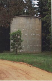
Photograph, Linton Water Tower, 2014
One of three colour photographs printed on a single sheet of photographic paper. The photograph shows a large concrete water storage tank - Linton's "water tower", located on high ground in Hamilton Street North.linton water tower, waterworks -
 Eltham District Historical Society Inc
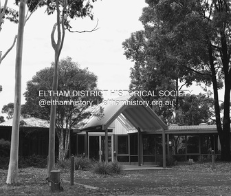
Photograph - Digital Photograph, Alan King, Wycliffe Centre, Graham Road, Kangaroo Ground, 2008
Wycliffe translates the Bible for people around the world. Published: Nillumbik Now and Then / Marguerite Marshall 2008; photographs Alan King with Marguerite Marshall.; p171 The peace and beauty of Australia’s Wycliffe Centre reflects what it aims to bring to thousands of people around the world. Kangaroos calmly feed, accompanied by bird song, near the mud-brick buildings set amongst Kangaroo Ground’s rolling hills. On 11 hectares off Graham Road, the centre aims to transform people’s lives by giving groups around the world, with no written language, help with literacy and Bible translation into their own tongue. Associate Director, Harley Beck, says reading the Bible (probably history’s most influential collection of books), in one’s own language, provides a strong moral basis, helping people withstand exploitation and escape poverty. One of Wycliffe’s field partners, SIL (formerly Summer Institute of Linguistics) Papua New Guinea, has won two UNESCO awards, and SIL branches in many other countries have won international and national awards. The translators are modern heroes. They undertake hardships, forsaking for years, sometimes decades, a salary and the soft western lifestyle, to face loneliness and primitive conditions that most of us would not even contemplate. No staff is paid a salary. An example is the first Australian Director and former International President, David Cummings, who for 50 years has depended on donations from supporters and churches. Students of all ages at the EQUIP Training School on the site come from all walks of life. They train in linguistics and learn how to communicate in a way that is sensitive to other cultures. Spiritual resilience is encouraged, enabling people to persist until the job in the field is done, which takes on average ten to 15 years. Courses range from a few weeks to a year. The Wycliffe concept was born in the 1920s when American missionary, Cameron Townsend, found a Spanish Bible was inadequate to evangelise the Cakchiquel people of Guatemala. When a Cakchiquel man challenged: ‘If your God is so great, why doesn’t he speak my language?’ Townsend decided to translate the Bible into all languages! He founded a linguistics training school in 1934, naming it after 14th century theologian John Wycliffe, the first to translate the Bible into English. The first Wycliffe Bible was completed in 1951 in the Mexican San Miguel Mixtec language. In May 2007 after 30 years of work, Wycliffe Australia, with other organisations, completed the first Bible for indigenous people in the Kriol* language, for about 30,000 people in northern Australia. Wycliffe Australia began in 1954 in the Keswick Bookshop basement, Collins Street, Melbourne. As the organisation grew, its quarters became so cramped that Director Cummings at times interviewed potential recruits in his car! The development of the Kangaroo Ground property is a story of faith and generosity. In 1967 Cummings proposed moving to a larger property despite having no funds. Within a month Wycliffe received a $20,000 donation and a gift of land towards a national centre. An earlier owner of the Kangaroo Ground property, Mrs Elsie Graham, would have been delighted, as she had wanted her land to be used for ‘God’s service’. Mud-brick architect and Christian, Alistair Knox, offered to design the centre at no charge. Despite a drought, straw was donated to make bricks. Many volunteers helped with the building, including church youth groups who made mud-bricks. Volunteers planted thousands of native plants, watered by recycled water from the site’s dam. Building began in 1968 and in 1983 the South Pacific SIL School (now EQUIP Training) followed. Wycliffe, the world’s largest linguistic organisation, and other organisations, have translated the Scriptures into more than 2000 languages. But another 2000 languages still lack any portion of the Bible. However translations are now completed more quickly, because of new computer programs and as education spreads, more speakers of the local language can assist. Despite the growth of secularisation, Beck says support for Wycliffe Australia, which has offices in all states and the ACT, is stronger than ever. * Kriol is a Pidgin language, which has become a speech community’s prime language.This collection of almost 130 photos about places and people within the Shire of Nillumbik, an urban and rural municipality in Melbourne's north, contributes to an understanding of the history of the Shire. Published in 2008 immediately prior to the Black Saturday bushfires of February 7, 2009, it documents sites that were impacted, and in some cases destroyed by the fires. It includes photographs taken especially for the publication, creating a unique time capsule representing the Shire in the early 21st century. It remains the most recent comprehenesive publication devoted to the Shire's history connecting local residents to the past. nillumbik now and then (marshall-king) collection, graham road, kangaroo ground, wycliffe centre -
 Linton and District Historical Society Inc
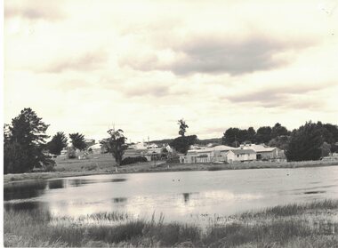
Photograph, View of Linton from across Edinburgh Dam, 1984
Image taken 1984. House on right in middle-ground belonged to Rutherford family (prior to this it was the police residence; it was moved to this site in the 1960s). Small white building near Rutherford house was formerly the Linton Railway Station office building.Black and white image of a body of water, Edinburgh Dam - in foreground. Houses and shops (along Sussex Street) in background."Linton from across the / Edinburgh Dam. The little / white hut behind Rutherfords / (right foreground) was the / office building from Linton / Railway Station, moved / to this site c. 1981/2".edinburgh dam, rutherford house -
 Stawell Historical Society Inc
Photograph, Stawell's Water System 1999 -- 8 Photos -- Coloured
Eight coloured photos of Stawell's Water system. a. Old Valve house Pomonal b. Old Valve house & inlet grating from tunnel cutting. c. Old Valve house & Main ground grill. d. Sludge trap. e. interior of water supply tunnel at Pomonal. f. Tunnel showing outlet litter trap with rake for cleaning trap. g. Tunnel entrance at Pomonal. h. Vandal shattered cncrete pipe with multiple wire reinforcing (old?) Eight colour photographs of buildings, tunnels and equipment in bush setting.grampians water supply -
 Bendigo Historical Society Inc.
Photograph - EDINBURGH TANNERY: SHEEPWASH CREEK, 1890 approx
In 1878, J H Abbott bought the Edinburgh tannery from Mr Lambert and Mr Sibley in 1878 and set about expanding and modernising it. Soon it consisted of the necessary sheds surrounded by cottages built for the workers. The tannery buidings and processes consisted of :- 1. Hide shed that held 400-500 salted hides 2. Salt pots where the salted hides were soaked to remove all salt 3. Lime water pits where the hides were soaked to remove hair and all adherent flesh. 4.Beam shed where hides were hung so they could be scraped clean with double handled knives 5. Water baths that soaked the hides to remove the lime 6. Tan yard where there were 10 pits containing tanning liquid made from ground wattle bark. The entire process could take up to 9 months depending on the type of leather required. A forward thinking initiative of this tannery was the lack of waste. The left over flesh was boiled down to make tallow, trimmings from the hides was used to make glue, hair was washed and used by saddlers and upholsterers and the lime was mixed with tanning liquid to produce fertilizer. The tannery was producing about 240 sides of leather a week, with about two thirds of this being sent to England where it was in great demand because of its quality. In December 1894 the plant was destroyed by a fire believed to have started in the engine room. The plant was quickly rebuilt at an estimated cost of ten thousand pounds. The plant at 145 Tannery Lane operated until 1906.Sepia photograph: 13 workmen, shed at rear. Brick, timber, corrugated iron buildings in back ground. Interesting industrial site of the time. Photo of workmen taken in front of open sheds. Brick chimney and pile on L.H.S. Suggests Edinburgh Tannery, Sheepwash. J.H Abbott & Co. On back on small piece of paper 1127 Bgo. New registration No. rather indistinct. James Lerk 26.11.1999, ' Edinburgh Tannery - Sheepwash?' Ken Arnold Book 'Bendigo A History in Bottles & Stoneware 1852-1930 p10. This photograph labelled 'Workers at Sheepwash Tannery,' C. 1880-1890 with section about J.H. Abbott & Co. See book 'Bendigo A History in Bottles & Stoneware 1852-1930 by Ken Arnold, p.10RHSV 1127, Bgoorganization, business, edinburgh tannery, sheepwash creek. -
 Bendigo Historical Society Inc.
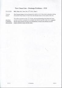
Document - DRAINAGE PROBLEMS - NEW CHUM LINE DRAINAGE PROBLEMS 1910
Handwritten extract from the Bendigo Advertiser 27/12/1910 Page 2. ''The Victoria Quartz, having deepened its shaft to 4,614 feet, had to abandon sinking on account of an inrush of water from the flooded mines to the south on the line. The influx occurred on the 15th of June, and notwithstanding that baling has been carried on almost constantly the company has failed to get the water out. It appears that the deep ground will have to be abandoned, owing to the absence of some proper scheme to cope with the water.'' Albert Richardson Mining History Collection.document, gold, drainage problems, drainage problems, new chum line drainage problems 1910, bendigo advertiser 27/12/1910 page 2, victoria quartz, albert richardson -
 Melbourne Tram Museum
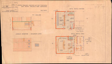
Drawing, Melbourne & Metropolitan Tramways Board (MMTB), "Carlton - Proposed new control room and remodelling of existing control room", May. 1961
Drawing - titled - "Carlton - Proposed new control room and remodelling of existing control room", coloured with a water colour brush, showing the proposed extensions to the Carlton control room, drawing Number S842, dated 9-5-1961. Shows the ground and first floors, mess room, offices, stairs and control room layout. Has the external elevations and sections.Has some pencil notations front and back re lights and sketch.trams, tramways, carlton, control centre, power supply, electrical engineering, electrical switching -
 Bendigo Historical Society Inc.
Document - MARKS COLLECTION: PLAN OF HOT WATER HEATER FORTUNA FOR G. LANSELL
Plan of hot water heater, Fortuna Villa, drawn on heavy paper. On top of plan in red ink 'Plan of Hot Water Heater for G. Lansell Esq for Fortuna Villa Sandhurst' Drawings show front, transverse, longitudinal, back and side elevations of heater, also back, side and front elevation of individual water heaters, including one with ornate screen. On bottom of document: floor plans of ground plan and basement. Plan stamped on RH bottom: William C. Vahland, Architect, Sandhurst.bendigo, house, fortuna villa -
 Lakes Entrance Historical Society
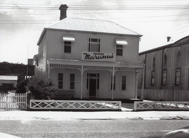
Photograph, Maranui Guest House Lakes Entrance, 1950c
Maranui was Kelvin House before it became Maranui This is the before paired photograph used in the 150 year,Lakes Entrance 1858-2008 display.|The after paired photograph number 01217.1 Also one 12 x 16 framed photograph used in room displayBlack and white photograph of Hoopers Maranui Guest House. A timber double storied building, hip roof, sun shades over upper windows, seat on ground floor veranda, lattice fence, side view of Prince Regent theatre beside building. Water tank on stand. Lakes Entrance Victoriafences, guesthouses, architecture, room display -
 Stawell Historical Society Inc
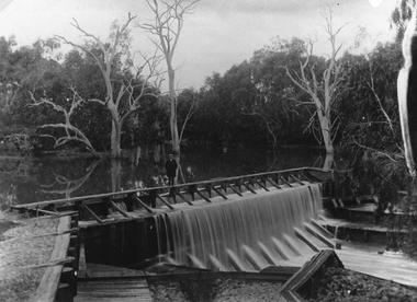
Postcard, Faux Weir on the Wimmera River near Lubeck 1909 -- Postcard
Faux Weir built across Wimmera River near Lubeck 1909. Worksheet records state photo copied from a postcard.Black & white photograph of a weir on a water body with trees in the back ground. A person is standing on the timber weir.water -
 Bendigo Historical Society Inc.
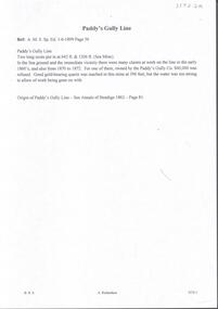
Document - PADDY'S GULLY LINE - NOTES ON PADDY'S GULLY LINE
Handwritten notes on Paddy's Gully Line. Two long Xcuts put in at 642 ft & 1206 ft. (Sea mine). In the Sea ground and the immediate vicinity there were many claims at work on the line in the early 1860's and also from 1870 to 1872. For one of them, owned by the Poaddy's Gully Co $40,000 was refused. Gold-bearing quartz was reached in this mine at 396 feet, but the water was too strong to allow of work being gone on with. On a separate piece of beige paper is written: Origin of Paddy's Gully Line - See Annals of Bendigo 1862, Page 81. Notes prepared by Albert Richardson.document, gold, paddy's gully line, paddy's gully line, notes on paddy's gully line, paddy's gully co, paddy's gully line annals of bendigo 1862 page 81 -
 Bendigo Historical Society Inc.
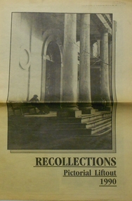
Newspaper - PETER ELLIS COLLECTION: RECOLLECTIONS PICTORIAL LIFTOUT
Historical lift out. Newspaper. Titled RECOLLECTIONS Pictorial Lift out 1990.1 looking down Mitchell St. from Railway Bridge. 2 Original railway station viewed from Mitchell St. bridge. 3 The great extended Hustlers mine. 4 1873 photo recently extended town hall with corn exchange at front left. 5 looking north westerly from city rec reserve at royal hustlers. 6 children play on mullock heap in front of a view of westerly quarter of Sandhurst. 7 Bank of Victoria, Mitchell St. left is Bendigo's original post office. 8 Looking down from what is now Rosalind Park. Shamrock Hotel can be seen on corner of Williamson St. and Pall Mall. This photo predates the construction of post office and law courts. 9 girl eating fairy floss. 10 4 kids on 1 horse in procession. 11 monkey and pedal car, a novelty attraction 1940's. 12 pony rides. 13 flying horses (ride). 14 processions past city hall. 15 Original ANZ bank corner Williamson St. & Pall Mall. 16 Chinese Dragons Bendigo Easter Fair 1940's. 17 City Hall viewed from Bull St. 18 City Hall original ceiling. 19 new town hall 1861. Mike Butcher, local historian. 21 Interior plan of city hall (ground floor) 22 circa 1920's 23 Tattered fragment original architect's drawing. 24 original assembly room. 25 Camp Hill PS Shamrock hotel without top story 27 shop with signage advertising Bushells, Bex and Swallow's Biscuits. 28 View from where fountain is now. 29 Hargreaves St. Looking south, now Hargreaves mall. Horse drawn water tank watering down road. 30 Central Deborah Gold mine poppet head. 31 Borough town hall, tram ways. 32 Original ANZ Bank corner Williamson St. and Pall Mall, demolished in mid 1960's. 33 Bush's store corner Williamson and Myer streets.34 Men on boat, don't know what or where. 35 Shearers. 36 men on a three wheeled bike. 37 4 Gold miners with shovels. 38 6pm closing, no trade Sundays, no women in main bar. 39 Peaceful scene Castlemaine 1940's Photographer Alan Doney. 40 Qantas Jet the City of Bendigo Tullamarine Airport. BCV-8 camera man & Advertiser photographer. 41 Ladies. 42 Tennis -> men and women (women in hats). 43 Sandhurst footy team. 44 Early school photos.bendigo, history, photographic history -
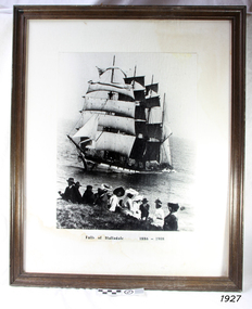 Flagstaff Hill Maritime Museum and Village
Photograph - Vessel, Sailing Ship, Falls of Halladale 1886 - 1908, 1908
The photograph shows some of the hundreds of sightseers who visited the site of the wreced Falls of Halladale, watching the fully rigged ship slowly disintegrate over two months or more. The Falls of Halladale was a four-masted sailing ship built in 1886 in Glasgow, Scotland, for the long-distance cargo trade and was mostly used for the Pacific grain trade. The ship was sturdy. It could carry maximum cargo and maintain full sail in heavy gales. It was one of the last of the ‘windjammers’ that sailed the Trade Route, and one of the first vessels to include fore and aft lifting bridges, which kept the crew safe and dry as they moved around the decks in stormy conditions. It was one of several Falls Line ships named after the waterfalls of Glasgow by its owner, Wright, Breakenridge & Co of Glasgow. On 4th August 1908, with new sails, 29 crew, and 2800 tons of cargo, the Falls of Halladale left New York, bound for Melbourne and Sydney via the Cape of Good Hope. The cargo on board was valued at £35,000. It included 56,763 tiles of American slate roofing tiles, 5,673 coils of barbed wire, 600 stoves, 500 sewing machines, 6,500 gallons of oil, 14,400 gallons of benzene, plumbing iron, 117 cases of crockery and glassware and many other manufactured items. The Falls of Halladale had been at sail for 102 days when, at 3 am on the 14th November 1908, under full sail in calm seas with a six knots breeze behind and misleading fog along the coast, the great vessel rose upon an ocean swell and settled on top of a submerged reef near Peterborough on south-west Victoria’s coast. The ship was jammed on the rocks and began filling with water. The crew launched the two lifeboats and all 29 crew landed safely on the beach over 4 miles away at the Bay of Islands. The postmistress at Peterborough, who kept a watch for vessels in distress, saw the stranding and sent out an alert to the local people. A rescue party went to the aid of the sailors and the Port Campbell rocket crew was dispatched, but the crew had all managed to reach shore safely by the time help arrived. The ship stayed in full sail on the rocky shelf for nearly two months, attracting hundreds of sightseers who watched her slowly disintegrate until the pounding seas and dynamiting by salvagers finally broke her back, and her remains disappeared back into deeper water. The valuable cargo was largely lost, despite two salvage attempts in 1908-09 and 1910. Further salvage operations were made from 1974-1986, during which time 22,000 slate tiles were recovered with the help of 14 oil drums to float them, plus personal artefacts, ship fittings, reams of paper and other items (a list of items held at Flagstaff Hill Maritime Village is included below). The Court of Marine Inquiry in Melbourne ruled that the foundering of the ship was entirely due to Captain David Wood Thomson’s navigational error, not too technical failure of the Clyde-built ship. The shipwreck is a popular site for divers, about 300m off-shore and in 3 – 15m of water. Some of the original cargo can be seen at the site, including pieces of roof slate and coils of barbed wire. ABOUT THE ‘FALLS OF HALLADALE’ (1886 - 1908) Built: in1886 by Russell & Co., Greenock shipyards, River Clyde, Scotland, UK. The company was founded in 1870 (or 1873) as a partnership between Joseph Russell (1834-1917), Anderson Rodger and William Todd Lithgow. During the period 1882-92 Russell & Co., standardised designs, which sped up their building process so much that they were able to build 271 ships over that time. In 1886 they introduced a 3000 ton class of sailing vessel with auxiliary engines and brace halyard winches. In 1890 they broke the world output record. Owner: Falls Line, Wright, Breakenridge & Co, 111 Union Street, Glasgow, Scotland. Configuration: Four-masted sailing ship; iron-hulled barque; iron masts, wire rigging, fore & aft lifting bridges. Size: Length 83.87m x Breadth 12.6m x Depth 7.23m, Gross tonnage 2085 ton Wrecked: the night of 14th November 1908, Curdies Inlet, Peterborough south west Victoria Crew: 29The Falls of Halladale shipwreck is listed on the Victorian Heritage Register (No. S255). It was one of the last ships to sail the Trade Routes. The ship was one of the first vessels to have fore and aft lifting bridges. The wreck is an example of an International Cargo Ship and represents aspects of Victoria’s shipping industry. The wreck is protected as a Historic Shipwreck under the Commonwealth Historic Shipwrecks Act (1976).Photograph, behind glass in a timber frame. Image of a group of people seated on the ground with the stranded barque, the Falls of Halladale, in full sail nearby in the water. The photograph was taken at Peterborough, southwest Victoria, on November 13th 1908. A typed inscription is below the picture.Typed beneath photograph "Falls of Halladale 1886 - 1908"flagstaff hill, maritime museum, maritime village, flagstaff hill maritime museum and village, great ocean road, shipwreck, peterborough, falls of halladale, 1908, barque, scotish, 4-masted, sailing ship, 1886, glasgow, trade, grain trade, cargo, windjammer, fore and aft bridges, falls line, wright, breakenridge & co, american slate, roofing tiles, barbed wire, sewing machines, oil, benzene, port campbell rocket crew, sightseers, salvage, captain david wood thomson, captain thomson, navigational error, clyde-built, russell & co -
 Eltham District Historical Society Inc
Film - Video (VHS), Nillumbik Shire Council, The Nillumbik Story, 1996
PART 1 – NILLUMBIK (00:00-07:17) Opening features various scenes around Nillumbik Shire. For 40,000 years Nillumbik was the home of the Wurundjeri people. Robert Hoddle gave the district its name. Jock Ryan, then president of Nillumbik Historical Society discusses the names Nillumbik and Diamond Creek. In the late 1830s white occupation began with gold found in Warrandyte in 1851 and 12 years later at Diamond Creek -the Diamond Reef which led to the Caledonian gold rush. Jock Ryan discusses the Diamond Creek mine, which was thriving until it burnt out in 1915. Large numbers of workmen moved into area in late 1870s to construct the Maroondah Aqueduct. With growing population of Melbourne, the nearby Yan Yean system had severely disrupted the flow of the Plenty River, forcing the closure of three flour mills there. The aqueduct came to the rescue carrying water 66km from Healesville to Preston. When the Diamond Creek gold mine burnt down the local economy suffered but fruit growing industry had already been established and Diamond Creek became a thriving fruit growing centre. Interview with Jack Powell, a long-time fruiterer at St Andrews market, his family had lived in the area for a hundred years, 3 to 4 generations, “a lot of hard work”. By the time the railway arrived fruit growing was no longer competitive. The railway brought the city closer and day trippers. The Green Wedge separates the shire from the more densely developed neighbours such as Whittlesea, Doncaster, Templestowe, Bulleen and Greensborough. Population at the time (1996) was 19,000 but links to the past remain strong. Mudbrick houses along the Heritage Trail The saving of Shillinglaw Cottage from demolition in 1963 and relocation brick by brick. PART 2 – ENVIRONMENT (07:18-14:44) Peter Brock (with Bev Brock in background) at St Andrews market discusses his childhood growing up in the district and the environment and the values it instilled upon him and his own family. The Brocks have been in the district since the 1860s. Nillumbik Shire responsible for managing three catchment areas; Diamond Creek, Arthurs Creek and Watsons Creek. Follows the course of the Diamond Creek commencing in Kinglake through the district to its confluence with the Yarra River at Eltham at Eltham Lower Park. Highlights Eltham Lower Park community revegetation program and the newly constructed (1996) viewing platform built of new and recycled timbers at the confluence of the Diamond Creek and Yarra River. Also featured are outdoor recreation on the river and at Eltham Lower Park including the Diamond Valley miniature railway. Sugarloaf reservoir and recreational activities and fishing. Aerial view of Memorial Park and Shire of Eltham War Memorial tower at Garden Hill, Kangaroo Ground. Significant tourism opportunities for the shire with 3 million potential day-trippers in metropolitan Melbourne. Council and community working together to find a way to promote the shires natural and artistic assets. At Arthurs Creek, the Brock family and neighbours working together to take care of their waterway. Peter Brock’s uncle, Sandy Brock talks about environmental management and the Arthurs Creek Landcare group and actions to eradicate blackberry problem. Having previously planted Cypress rows they are replacing them with indigenous species to improve the water supply, keeping cattle out of the creek bed to improve the quality downstream flowing into the Yarra. Eltham East Primary School Band playing “All things bright and beautiful” merges into scenes of the bushland sanctuary set aside by the school in 1980 with unidentified teacher discusses the sanctuary and their education program and school children’s comments. Plight of a family of Wedgetail eagles nesting in the path of a developer’s bulldozer at North Warrandyte and actions to save their nesting areas. PART 3 – ARTS (14:45-22:00) Arts and Jazz festival at Montsalvat featuring interviews with Sigmund Jorgensen discussing Montsalvat and its principles. Also Matcham Skipper. Clifton Pugh’s funeral at Montsalvat and his legacy at Dunmoochin near Cottlesbridge with artists in residence, at the time, Chicago artist Charles Reddington who discusses the benefits of the experience. An unidentified female artist also talks about the program and why people are drawn to the area. Unidentified man on street talking about the amount of talent in the area, artists, poets, musicians, authors. Artist Ming Mackay (1918-2009) interviewed talking about the people she mixes with on “the Hill”. Works of local artists are displayed Eltham Library Community Gallery and Wiregrass gallery with a new coffee shop at the Wiregrass making it an even more popular destination. Music at St Andrews Hotel (may be a little bit country) and the Saturday market where likely to hear anything. Sellers and patrons at the market asked about what attracts them to the market and where they came from. Scenes of poets/authors giving readings. CREDITS Music by John Greenfield from the CD Sweet Rain “The Snow Tree”, Uncle Music UNC 2001 Cameras - David Mirabella and Peter Farragher Editor – Olwyn Jones Written and Produced by Jason Cameron A Jason Cameron Proction for Nillumbik ShireProvides a record of the relatively newly created Shire of Nillumbik at the time and the features and attactions of the shire in its people arts, culture and environmentVHS Cassette (five copies) DVD (one copy) Converted to MP4 file format 0:22:00, 1.60GBvideo recording, arthurs creek, arthurs creek landcare group, artists, artists in residence, arts, arts festival, authors, blackberry, brock family, bulldozer, bulleen, bushland sanctuary, caledonian gold rush, charles reddington, clifton pugh, cottlesbridge, cypress rows, developer, diamond creek, diamond creek mine, diamond reef, diamond valley miniature railway, doncaster, dunmoochin, education program, eeps, eltham, eltham east primary school, eltham east primary school band, eltham library community gallery, eltham lower park, environment, fishing, flour mill, fruit growing, fruiterer, garden hill, gold mining, green wedge, greensborough, heritage trail, hurstbridge railway line, jazz festival, jock ryan, kangaroo ground, kangaroo ground tower, kinglake, maroondah aqueduct, matcham skipper, memorial park, ming mackay (1918-2009), montsalvat, mudbrick houses, music, musicians, nesting area, nillumbik historical society, nillumbik shire, north warrandyte, old timer, orchards, peter brock, plenty river, poets, population, recreation, recreational activities, revegetation, robert hoddle, sandy brock, shillinglaw cottage, shire of eltham war memorial, sigmund jorgensen, st andrews hotel, st andrews market, sugarloaf reservoir, templestowe, the hill, tourism, viewing platform, warrandyte, water catchment area, watsons creek, wedgetail eagle, whittlesea, wiregrass gallery, wurundjeri, yarra river, jack powell -
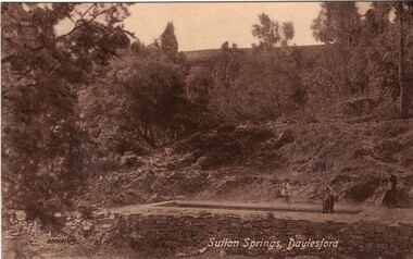 Ballarat Heritage Services
Photograph - Photograph - Black and White, Sutton Spring, Daylesford
Emerging from the base of Wombat Creek Sutton Spring has two mineral water pumps. The spring is named after the Sutton brothers of Cornwell, who discovered it while looking for alluvial gold along Wombat Creek in the 1850s. By 1900, a trench had been dug to expose the spring, and a pipe had been driven through the spring eye. Sandstone rockwork encircled the trench. On 27 February 1907 the Sutton Mineral Spring Reserve was gazetted. By that time the trench had been enlarged and rendered, and a lean-to shelter had been built over the approach track. In 1927 Wombat Creek was rerouted allowing the land around the spring to be cleared and pipework repaired. Five bores were dug in 1929 and equipped with hand pumps. The bores were all shallower than 9.7 m. An attempt was made to replace one of these bores with a new bore, however it was not possible due to ground instability. These two bores are the oldest of all the mineral springs open to the public. Also in 1929 Council contemplated encouraging private enterprise to establish a ‘hydrobath’ similar to those in Europe, after mineral water had been discovered flowing from several other vents in sandstone and slate strata below the typical level of the creek. However, the option was not enacted although at the time to capture the flow another bore to a depth of 15m was sunk. In 1936 architect P. Scott Williams adopted a similar notion and examined the prospect of establishing a Hydropathic establishment above Sutton Springs, assuming a reliable mineral water supply could be found. That idea also lapsed. In October 1997 the Sutton Spring trench was restored to enable the public to again take mineral water at the spring. The restoration included clearing the sides of the creek and removing willow root growth. In 2002 a major overhaul of the trench and its underground works was undertaken and all plumbing replaced. This involved re-routing the creek through sandbagging, covering the spring eye with geofabric and then concrete. Unfortunately due to ongoing water quality issues, public access to take water from the trench was closed, however the trench can still be viewed.A mineral water spring at Daylesford is surrounded by a drystone wall. mineral water, sutton spring, daylesford, central springs, p. scott williams -
 Glenelg Shire Council Cultural Collection
Photograph - Framed Photograph, Tim Kanoa, The Fighting Gunditjmara Warrior, 2014
Coloured digital print of a Gunditjmara man standing in water up to his waist, he is looking down at his hands with are together and open palmed. The man features white painted dots and lines over his chest, upper arms and across his nose and under eyes. The sky is visible in the back ground and is overcast.Nonegunditjmara, warrior -
Moorabbin Air Museum
Film (Item) - (SP) Various films 16mm and 8mm MAM 1001 to MAM 1011 - RAAF Go to Media tab and download spreadsheet to see index
Helicopter based airline proposition. Water landing Taxying & take off capability. B & W Sound Demo landing & Take off land, snow & water. Weights & performance. Army variant takes 34 troops. Colour silent Jetstar sales video. Specs. Performance. First flight. Corporate & military uses. Colour sound Turbojet history technology. Whittle. Nene Vampire Meteor B&W sound Before 1st flight.Publicity film. New technologies. Cockpit features. Specs, performance. Colour sound Activity at Bankstown and Wagga 1943 Various WW2 aircraft. Inc medivac. On ground & in flight. B&W part sound. Has film break Shots of medivac A/c (Ref MAM 1006) John Gould bird extracts Forces and Moments on an aircraft. B&W sound Aircraft control modes - Pitch, directional, lateral B&W sound Publicity film C130 Hercules. Loading freight persons. In flight. Colour sound Boomerang info. In flight B&W -
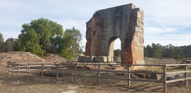 Ballarat Heritage Services
Photograph, Grand Duke Mine, Timor, Victoria, 04/05/2025
... the lives of four men. As the ground here was so wet, pumping water... the lives of four men. As the ground here was so wet, pumping water ...Running through this reserve was one of Victoria's richest gold deep leads. From 1869 to 1896 this mine produced 216,000 ounces of gold, valued at over £885,000. The Timor area was mainly mined by the Duke and Timor Gold Mining Company, later known as Duchess of Timor, Duke, and Grand Duke. On 03 May 1869, at a traditional afternoon ceremony, the machinery was started and launched by the old process of 'giving it a name'. A baptismal ceremony was performed, with a Miss Eliza Watson dashing a bottle of champagne over the fly wheel on its first revolution and proclaiming its name to be 'The Galatea'. The mine here was renowned for the massive pumping engine it boasted. Imported from England, the massive Cornish pump was an improvement that was added in 1874. It had a 30 ton iron beam. The mine was the economic centre of this area, employing hundreds of men over its 27 years. At the height of its operation the company's proprietors boasted that nearly all the inhabitants of the nearby towns of Timor and Bowenvale depended on the mine for support. There were some tumultuous times at the mine, with periods of financial strife as well as accidents. When the pumps broke down in 1879 the mine flooded and remained out of action for two years. Mining was a dangerous occupation and a tragic accident in December 1883 claimed the lives of four men. As the ground here was so wet, pumping water out of the mine was crucial to safely reach the gold. It was this pumping engine, reported to be the largest of its kind in Australia, and comparable in size to just two others in the world, that was the key to the success of the Grand Duke mine. Many other smaller nearby mines also had their water pumped out. During the last seven years of the mine's operation it pumped out 2,000 gallons of water every minute, making this the longest and most continuous wet mine in the state. As well as the pump house and engine, there were four main shafts, 12 Cornish flue boilers, eight iron puddling machines and one battery of 20 heads. A massive pumping engine The arch before you is all that remains of the pump house that served to remove water from this mine. When mining started at Timor in the late 1860s the ground here was very wet. If miners were to have any success in reaching the gold they had to remove the water from the ground. To deal with this challenge the company imported a massive Cornish pumping engine from England to pump water out of the mine. It was reputed to be one of the best pumping engines in the world at the time. The engine generated 270 horsepower and its iron beam, weighing 30 tons, was the largest in Victoria. The beam of the large pumping engine see-sawed on this pump house wall to move the plunger or bucket in the pump up and down. The vertical cylinder was 80 inches in diameter with a stroke of 10 feet. The piston itself was eight inches in diameter and 17 feet high and the piston pump had a diameter of 22 inches. For such large engines a massive wall to support the beam was necessary. The piston operated on the downstroke and consequently the cylinder had to be anchored to a considerable foundation to overcome the weight of the pump rods in the shaft. The whole apparatus had to be contained in a tall building because of its vertical configuration. The pumping engine's building has beam walls six feet wide and over 26 feet long which rest on foundations 16 feet deep. The granite used to construct the arch was quarried at Mt Hooghly, some eight or nine kilometres away.Colour photographs of the Grand Duke Mine at Timor near Maryborough, Victoria.grand duke mine, timor, maryborough, mining, duke and timor gold mining company, duchess of timor -
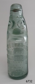 Flagstaff Hill Maritime Museum and Village
Domestic object - Codd neck bottle, E. Rowlands, 1921
The design of the bottle is called a Codd, sometimes referred to as a marble bottle or "Codd's patent bottle". During the mid-to-late 1800s, there were many inventions to keep the fizz in carbonated drinks such as ginger ale, soda water, and fruit drinks. Hiram Codd, an English engineer invented a successful process that he patented as "Codd's patented globe stopper bottle" in 1872. The Codd-neck bottle (commonly called Codd or marble bottle) is manufactured in two parts. The body of the bottle is cast in two sections. At the time of joining the sections, glass marble and rubber seal are inserted into the neck section. The lip is then applied to the top of the bottle. The Codd bottle is filled upside down as the pressure of the gas from the carbonated liquid holds the marble up and out of the way. When the bottle stands upright the gas pushes the marble up against the washer, creating a firm seal to keep the fizz inside. The bottle is opened by pushing the marble down firmly to allow some of the gas to escape. The marble drops down and is caught in a depression formed in the neck. When the bottle is tilted to pour or drink the liquid the marble rests in a dimple. Two Ballarat miners, Evan Rowland and Robert Lewis started manufacturing mineral and aerated waters, bitters, cordials, and liqueurs in 1854, in a tent on the shores of Lake Wendouree Ballarat. Another 13 firms at that time employed manual operations, whereas they introduced Taylor's No. 1 machine that speeded up the process and laid the foundation for their fortune. Evan Rowland was a pioneer in the aerated water trade in Australia. He was born on August 2, 1826, in North Wales. In 1852, during the gold rush, he emigrated to Melbourne, and in 1854 he went to Ballarat and formed a partnership with Robert Lewis, the firm being called ‘‘Rowlands & Lewis’’. Their next step was to secure a supply of pure water. Using mineral Waters that they found via a natural spring at Warrenheip, Victoria. From the outset, the beverages made from this water gained repute and were in great demand. Their business prospered so well that in 1858 they were able to build a factory at the corner of Sturt and Dawson Streets, Ballarat, and to fit with the most up-to-date machinery then in use. By 1870 their business had increased so much and demand had grown to such an extent that Mr. Rowlands erected another factory, covering over an acre of ground at the corner of Dana and Doveton Streets, costing £13,000. The factory was fitted with the most modern equipment of the time to manufacture cordials and aerated water. In 1873 Rowlands established an agency at 116 Collins St, Melbourne, because the demand for the products of the Melbourne factory became so large. The company expanded to Sydney opening a factory at the corner of Burns & Hay Streets Darling Harbour obtaining spring water to supply this plant from Katoomba in the Blue Mountains. The water was brought to Sydney by rail. In the meantime, the Melbourne concern had progressed so rapidly that in 1888 a magnificent factory embodying all the latest ideas and equipment was built in King Street Melbourne. Robert Lewis was a fellow Welshman born in 1816, and he arrived in Port Phillip in 1853 and became a partner in the early day with Evan Rowland but with lesser and shorter involvement in the firm, from which he retired in 1876. Robert Lewis was perhaps better known as Ballarat's first mayor and a Member of the Legislative Assembly. He was a strong supporter of local charities, president/treasurer of the Eisteddfod Committee, a major force in the development of the Ballarat Hospital, and he was the mayor of Ballarat five times, the first in 1863, (having been a counsellor as early as 1859) and for the last time in 1881. Lewis died in 1884 of a stroke in Ballarat. Rowlands continued in the firm and invented and patented an improved soda water bottle. The water used in Rowlands products was filtered four times but his attempts to use local corks failed on quality grounds. He was a stickler for quality, which was so good that many outside Victoria were prepared to pay the 'premium' imposed by inter-colonial customs duty payable at that time. By the 1890s, Rowlands had factories in Ballarat, Melbourne, Sydney, and Newcastle. He died in 1894 but his company continued until well after the Second World War when it was sold to Schweppes. Bottles such as this popular brand, containing soda water, were often used on paddle steamers for refreshments.An early manufacturing process producing the first mineral waters in Australia was invented and developed by an early Welsh migrant to Australia. The Evan Rowlands story gives an insight into the early development of manufacturing industries in Australia that allowed their workers and the towns they were situated in to prosper and develop into what they are today. A good example of hand blown glass.Bottle; clear glass Codd neck bottle with small marble in top. Once contained soda water or soft drink. Manufactured in 1921 by E. Rowlands of Ballarat, Melbourne, Katoomba and Sydney. The bottle is 'recyclable' - the message on the base says that it remains the property of E. Rowlands Pty Ltd. Inscriptions on three adhesive labels at time of donation"E. ROWLANDS BALLARAT MELBOURNE KATOOMBA AND SYDNEY". Imprinted into bas "1921" "THIS BOTTLE REMAINS THE PROPERTY OF E. ROWLANDS PTY LTD" On adhesive labels (3) " 1921 ON BASE (LASTED 1924) CODD PATENT 702" "SMALL SIZE. MARBLE TOP SODA WATER PAPER LABEL. USED" "ON PADDLE STEAMERS. POPULAR BRAND"flagstaff hill, warrnambool, shipwrecked-coast, flagstaff-hill, flagstaff-hill-maritime-museum, maritime-museum, shipwreck-coast, flagstaff-hill-maritime-village, bottle, codd bottle, hiram codd, glass marble bottle, e. rowlands bottle manufacturer, soda bottle australia, early recyclable bottle, codd's patent bottle, marble bottle, refreshments, soda water, marble top, 1920s, codd patent 702, handmade, blown -
 Bendigo Historical Society Inc.
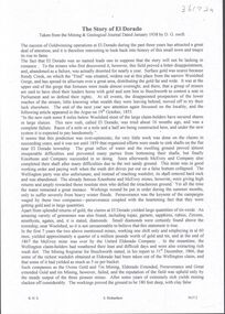
Document - ELDORADO - THE STORY OF EL DORADO
... the disappointments, difficulties with water and the ground and floods... with water and the ground and floods, As well as gold they also found ...Typed notes titled 'The Story of El Dorado' taken from the Mining & Geological Journal, dated January 1938 by D. G. Swift. Notes typed by L. G. Schilling, 13/10/69. Notes mention the disappointments, difficulties with water and the ground and floods, As well as gold they also found large quantities of tin oxide and a large variety of gemstones. A powerful jet of water was used for the mining.document, gold, eldorado, eldorado, the story of el dorado, mining & geological journal january 1938, d g swift, the argus 19/10/1855, kneebone & company, wellington party, mcevoy mine, kneebone mine, tin oxide, gemstones, united eldorado company, mining registrar, ovens gold and tin mining, eldorado extended, perserverance, great extended gold and tin mining, wellington company, mr william dunstan, united ovens gold and tin, the warrior, try again company, mcevoy disaster, cock's pioneer electric gold and tin sluicing company, mr h falsoner, cock's pioneer gold and tin mines n l company, state electricity commission, hydraulic sluicing, gold dredge, cock's eldorado company, l g schilling -
 Bendigo Historical Society Inc.
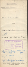
Document - H.A. & S.R. WILKINSON COLLECTION: CONTRACT OF SALE
This business was owned by father and son, Henry Archibald Wilkinson and Samuel Ronald "Ron" Wilkinson. Henry (1882-1954) was born in Shepparton and died in Bendigo. He was married to Grace Hovendon in 1908. Samuel Ronald "Ron" (1914-1995), Henry's son, was married to Florence Jean McKerlie in 1937.Contract of sale of land dated 10th February, 1956 between Mr. T.J.K. Gilbert (seller) and Mr. L.F. Rule (buyer) for land being allotment 14p section L, containing 19 acres 3 roods and being land described in certificate of title volume 6375 folio 936 and situate Marong Road, Bendigo. Together with all buildings thereon, also piping and loose galvanized iron on ground, with State Rivers and Water Supply Authority to irrigate 1 acre land. Price 650 pounds. Also attached a letter in two copies signed by Mr. Rule agreeing to the purchase, the letter is dated 7th February, 1956 and is on H.A & S.R. Wilkinson letterhead.organization, business, h.a. & s.r wilkinson real estate -
 Bendigo Historical Society Inc.
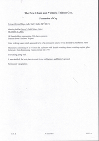
Document - NEW CHUM & VICTORIA TRIBUTE COY - EXTRACT OF MEETING
New Chum and Victoria Tribute Coy. Formation of Coy. Extract from Bendigo Advertiser Saturday July 22, 1871. Meeting held at Sterry's Gold Mines Hotel. Mr. Sterry in Chair. 18 shareholders representing 504 shares present. Extracts from Director's Report. After striking water which appeared to be of a permanent nature, it was decided to purchase a plant. Machinery consisting of a 14-inch dia. Cylinder with double winding drums, winding engine, plus boiler etc. from Buningong. Same erected for 750 pounds. Everything going well. It was decided, the best place to erect it was on Burrows and Sterry's ground. Permission was granted.document, gold, new chum & victoria tribute coy, extract of meeting new chum & victoria tribute coy, bendigo advertiser, mr sterry, gold mines hotel, mr burrows -
 Bendigo Historical Society Inc.
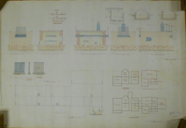
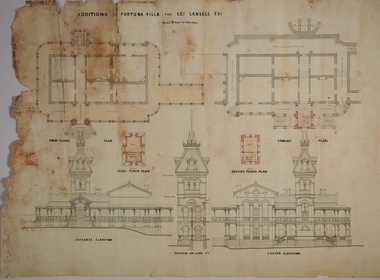
Plan - MARKS COLLECTION: PLAN FOR FOUR LEVEL STAIRCASE TOWER TO GARDEN ELEVATION AT FORTUINA VILLA FOR GEO. LANSELL ESQ
Fortuna Villa was owned from 1855 to 1871 by Christopher and Theodore Ballerstedt, Australia’s first mining magnates. In 1871 it was purchased by George Lansell (The Quartz King) being one of Australia’s most successful and adventurous nineteenth century gold mine owners and speculators. Lansell made numerous alterations and extensions to the building and it remained in the Lansell family until 1935.Plan for four level staircase tower to the Garden Elevation of Fortuna Villa, Sandhurst for George Lansell Esq. Plan details: * Plan shows ground, First, second and third floor plans for the staircase construction * First and second floor house plans and location of staircase addition * Front and Garden elevations with staircase addition Plan coloured and damaged on LHS, also with water damagebendigo fortuna villa, george lansell, building plans, c & t ballerstedt -
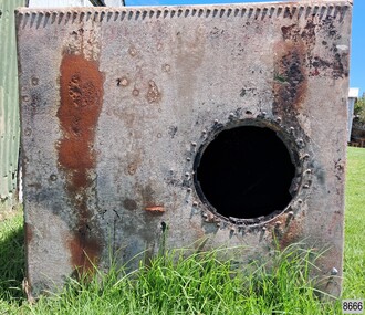 Flagstaff Hill Maritime Museum and Village
Container - Ship Tank, Early 20th century
Cubed iron ship tanks were invented by Richard Trevithich in 1808, in partnership with Robert Dickson, and the design was patented that year. The invention eventually replaced the wooden casks or barrels used at the time, as the ship tanks were more secure and their shape was much more economical in storage space. The robust metal tanks were originally made to transport water, but their preserving quality enabled them to transport perishable dry goods such as grain on long voyages, as well as other forms of liquid and solid cargo. The first ship tanks were made from sheets of iron, and later mild steel sheets, with double riveted edges and corners. A round cast iron lid with handle grips was fitted snugly into the top opening, providing an air-tight and water-tight seal. Brass taps were often fitted into the base, which could have been the case with this tank, but it now has a wooden bung in the hole. Sailing ships began using the new ship tanks on Australian voyages from around the 1830s, storing food and water for those on board, and filling them with other cargo. A large number of the ship tanks were repurposed in 1838 for the Victoria Settlement at Port Essington, N.T., as they were able to protect the food, clothing and other stores from termite and insect damage. Other ‘recycled’ ship tanks were cut in half and used as washing tubs or cookers. A 1929 catalogue from Hudson’s Tank Stores advertised square tanks that contained around 600 litres – 160 gallons – which equals an internal measurement of 33.25 inches – 84.5 centimetres – per side ship tanks are still made and sold in 1952 by the Globe Tank and Foundry in Wolverhampton, England, which was incorporated in 1922. Today, ship tanks can be seen around Australia. Wilsonson’s Promontory Lightstation has the lid from a ship tank that was used on site for the storage of water. Some have been repurposed as domestic water tanks and dog kennels, others for eucalyptus distilleries. Flagstaff Hill has two ship tanks. The Campaspe Port at Echuca, once a bustling river port, has a ship tank beside the locomotive yard. The lids of ship tanks are collectible items. Richard Trevithick (1771-1833): - Trevithick was born in 1771 in Cornwall, England. He was a famous British engineer and inventor during the Industrial Revolution, known for his invention of the first full-scale working railway, the high-pressure steam locomotive, which he demonstrated hauling a railway train in 1804. He set up a small workshop in 1808 at 72 Fore Street, Limehouse, London, to make iron ship tanks, and this invention was instrumental in replacing the wooden casks formerly used for storage on ships. He was involved with mining technology, iron foundry and ship equipment. Ship tanks changed the way that cargo was transported on ships and other vehicles from the 1830s and were used into the mid-20th century. The ship tanks’ advantages were that they could store more content, lasted longer, were waterproof and airtight, stackable and could be repurposed for many uses other than water, such as fuel, dry goods and domestic cargo. They have even been used aa dog kennels and cookers. Ship tanks were part of the evolving methos to transport water, food and cargo, which changed in 1956 when Malcolm McLean invented the large, rectangular shipping containers that are in use today; they speed up the process of loading on and off the ships, saving time and money. Ship tank: a cubed iron container with an offset hole on one side. The hole has cutouts for securely attaching a lid. This tank is on its side on the ground with the opening facing sideways. The side facing upwards has a wooden bung in a round hole. The ship tank is made from six square, thick iron sheets, rolled and riveted along the edges. The inside has a black sticky coating, possibly bitumen, and a strong creosote odour. There are small remnants of green paint on the outer surface.flagstaff hill, flagstaff hill maritime museum and village, warrnambool, maritime museum, maritime village, great ocean road, shipwreck coast, iron cube, water tank, shipping container, ship tank, ship's tank, ship tanks, marine container, richard trevithich, 1808, robert dickson, water transport, water storage, iron foundry, steel sheets, iron sheets, revets, victoria settlement, port essington, globe tank and foundry, wolverhampton, british engineer, british inventor, wooden casks