Showing 3053 items
matching highway
-
 Ringwood and District Historical Society
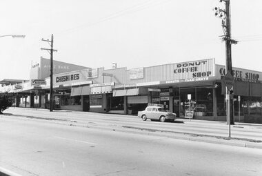
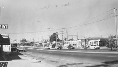
Photograph, Railway Station precinct shops, south side of Maroondah Highway, Ringwood - 1969
Black and white photograph Image shows shops on south side of Maroondah Highway between railway station entrance and clocktower site at Wantirna Road. -
 Ringwood and District Historical Society
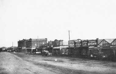
Photograph, Maroondah Highway Central, Ringwood. Shops in Maroondah Hwy, 1923
Black and white photograph (2 copies) Typed below photograph: "Maroondah Highway Ringwood 1923. Shops in foreground later to become Safeway and Eastland car park." -
 Ringwood and District Historical Society
Photograph, Maroondah Highway Central, Ringwood. Shopping strip on the south side opposite Town Hall and Midway Arcade- 1974
Black and white photograph (2 copies)Backing sheet reads, "Shops opposite Town Hall and Midway Arcade 1974". ANZ Bank at 116 Maroondah Highway. -
 Ringwood and District Historical Society
Photograph, Maroondah Highway Central, Ringwood. Looking west from Warrandyte Road, 1960. Taken from clock tower
Black and white photograph (2 copies)Written on back of one copy: "Maroondah Highway looking west from clock tower, 1960. Road being reconstructed." -
 Stawell Historical Society Inc
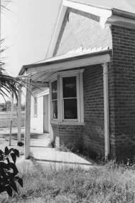
Photograph, Wehl Family home "Carlsruhe" on the Western Highway
Front Corner of Living Room and bay Windows Private Home "Carlsruhe" Western Highway (Wehl) Family Demolished 1993stawell -
 Warrnambool and District Historical Society Inc.
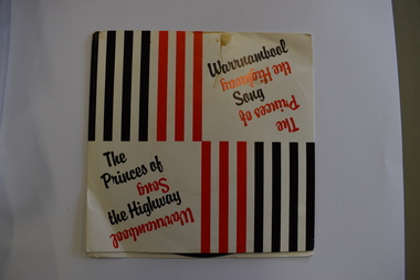
Audio - 45 R.P.M. Record, The Princes of the Highway, 1986
This record features two songs about the city of Warrnambool, 'The Princes of the Highway' and 'Warrnambool Song'. The first-named is a reference to the fact that Warrnambool is on the Princes Highway and the 'princes' are those who grew and picked potatoes in times past. The lyrics are by a former Warrnambool resident, Camilla Fligelman and the singer is John Stevens. Warrnambool is a city in the western district of Victoria servicing an agricultural area, particularly the dairying industry. This record is of interest as one of several recordings made over the years celebrating the city of WarrnamboolThis is a 45 R.P.M. record with a red -coloured centre and black printing. It is enclosed in a thin cardboard envelope which has red and black lines and printing on the front and the lyrics of the two songs on the back.warrnambool songs -
 Ringwood and District Historical Society
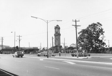
Photograph, Maroondah Highway and Wantirna Road intersection 1969
Black and white photographImage shows clocktower in new location on corner of Maroondah Highway and Wantirna Road, and shops including Antwan's hair fashions and OPSM. -
 Ringwood and District Historical Society
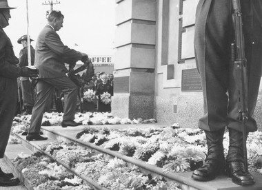
Photograph, Clocktower re-opening on corner Maroondah Highway and Wantirna Road, Ringwood - December 1967
Black and white photographImage shows Mr. Bill Kelly (R.S.L.)laying wreath at clocktower in new position corner Maroondah Highway and Wantirna Road. -
 Ringwood and District Historical Society
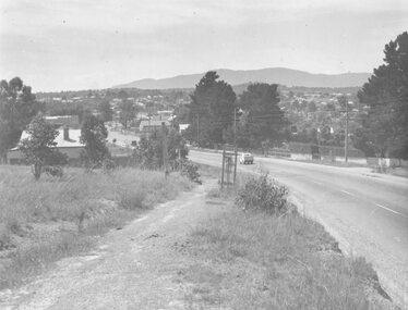
Photograph, Maroondah Highway West, Ringwood- c1948. Looking East from Heatherdale Road
Black and white photograph (2 copies)Typed below photograph: "Maroondah Highway. Taken from near Heatherdale Road - 1948". Written on back of another copy, "Coming into Ringwood". -
 Ringwood and District Historical Society
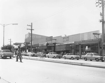
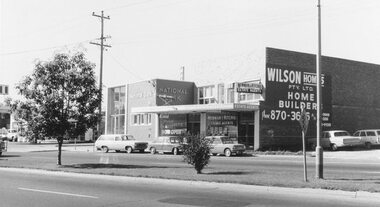
Photograph, Maroondah Highway West, Ringwood- 1969. Near Wantirna Road
Black and white photographWritten on back of photograph: "May 1969" Image shows 'National Bank', and 'Newman & Ritchie Estate Agents' on south side of Maroondah Highway. -
 Ringwood and District Historical Society
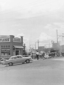
Photograph, Maroondah Highway East, Ringwood- 1964. Water main repair work on the north-east corner of Maroondah Hwy and Warrandyte Road
Black and white photographWritten on back of photograph: "New water main, corner Warrandyte Rd. and Maroondah Highway. 1964." Building on corner occupied by 'Spotless Cleaners & Launderers'. -
 Ringwood and District Historical Society
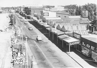
Photograph, Maroondah Highway Central, Ringwood. Looking east from old town hall - 1958, 1958
Black and white photograph (2 copies- 1 large, 1 small)Typed below photograph: "Maroondah Highway looking east from old town hall - 1958". Image shows Clocktower to left, stationmaster's residence in centre. -
 Ringwood and District Historical Society
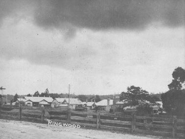
Photograph, Maroondah Highway Central, Ringwood. View of buildings on Maroondah Highway Ringwood, taken overlooking railway yard from Station St. and Greenwood Ave., 1914
Black and white photograph (2 copies)Typed below one photograph: "View of buildings on Maroondah Highway taken overlooking railway yard from Station St. and Greenwood Ave. 1914". Written on rear of backing sheet: "View of township taken from near the Methodist Church showing railway yards, Ringwood Hall and Methodist Church Hall. Methodist Church closed 1915. Photo taken from new one (Cnr. Greenwood Ave.)". -
 Ringwood and District Historical Society
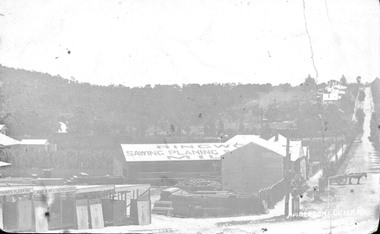
Photograph, Maroondah Highway Central, Ringwood. Bamford's Timber Yard, Warrandyte Road, (Formerly Andersons Creek Rd.) Cnr. Maroondah Highway
Black and white photograph (3 copies- 2 large, 1 small postcard) Typed below one large copy: "Warrandyte Road, (formerly Andersons Creek Road.) Cnr. Maroondah Highway. Bamfords Timberyard in foreground later redeveloped as the site of Safeway's site and area beyond it now Eastland." Written on rear of backing sheet: "Bamford Bros. Timberyard - (later) Safeways C/r Whitehorse Rd. and Warrandyte Rd. Looking Nth along Warrandyte Rd. Loughnans Hill to left" -
 Ringwood and District Historical Society
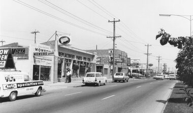
Photograph, Maroondah Highway East, Ringwood- 1969. Looking towards Ringwood from 'Repco' premises
Black and white photographImage shows businesses on south side of Highway, including John Salisbury Mowers, Repco, Maroondah Auto Electrics, Chemist, and Alan Coffey Motors used cars. -
 Ringwood and District Historical Society
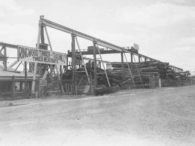
Photograph, Maroondah Highway West, Ringwood- 1948. Ringwood Timber & Trading Co., timber yard
Black and white photograph (2 copies)Typed below photograph: "Ringwood Timber and Trading Co's original timber yard, Maroondah Highway, corner New St. - 1948. 1982 site Target Project." -
 Ringwood and District Historical Society
Photograph, Maroondah Highway West, Ringwood- c1920. Looking East from Heatherdale Rd
Black and white photograph (2 copies)Typed below photograph, "Maroondah Highway from Heatherdale Rd. Circa 1920". Written on backing sheet, "Whitehorse Rd. coming into Ringwood from Heatherdale Rd." -
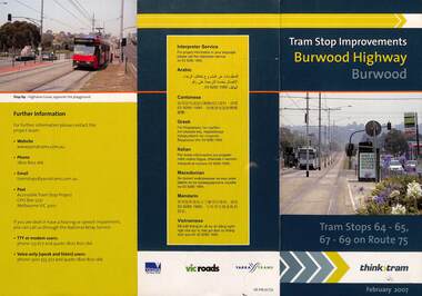 Melbourne Tram Museum
Pamphlet, VicRoads, "Tram stop improvements Burwood Highway Burwood", Feb. 2007
Pamphlet dated Feb. 2007 detailing the installation of platform or super stops in Burwood Highway Burwood in four locations. Has location map. Part of the VicRoads Yarra Trams Think Tram project. Route 75.Yields information about the installation of super stops in Burwood Highway during 2007.Pamphlet - 3 fold DL - full colour.trams, tramways, super stops, platform stops, route 75, burwood highway, burwood -
 Whitehorse Historical Society Inc.
Pamphlet, Maroondah Highway, Nunawading, 1/10/1999 12:00:00 AM
Auction brochure for 360 Maroondah Highway, Nunawading [Whitehorse Road].Auction brochure for 360 Maroondah Highway, Nunawading [Whitehorse Road]. 3 lots for auction, 27 October 1999. Agent; Collier. Site of the former Nunawading Council Chambers. Includes aerial photo of Nunawading including Whitehorse Rd / Springvale Rd corner and Nunawading Railway Station area.Auction brochure for 360 Maroondah Highway, Nunawading [Whitehorse Road]. whitehorse road, nunawading, no 360, city of nunawading. council chambers, municipal chambers, springvale road, nunawading, nunawading railway station -
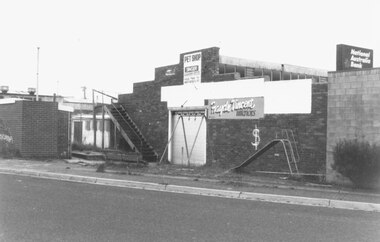 Ringwood and District Historical Society
Photograph, Ringwood Arcade, 92 Maroondah Highway. Front and Rear before demolition 1987
Written on back of photograph SS0377b: "14.2.1987. Ringwood Arcade, 92 Maroondah Highway. To be wrecked and redeveloped.'ON back of SS0377a: "14/2/87. Rear entrance of Ringwood Arcade" -
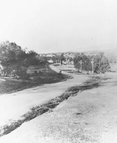
 Ringwood and District Historical Society
Photograph, Maroondah Highway East, Ringwood. Excavations for Ringwood Lake overflow, 1963
Black and white photograph (3 copies- 2 large, 1 small)Written below one photograph: "Ringwood Lake overflow pipe (under Maroondah Highway) - 1963". Typed below a similar image: "Overflow from Ringwood Lake- 1963." -
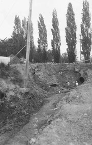
 Ringwood and District Historical Society
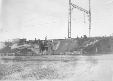
Photograph, Maroondah Highway East, Ringwood- 1923. Start of Warrandyte Road railway bridge construction
Black and white photograph (3 copies- 2 large, 1 small sepia)Typed below large photograph: "Building Warrandyte Rd. subway 1923. Taken from Maroondah Highway." Written on rear of backing sheet: "Start of Pitt St. viaduct." -
 Ringwood and District Historical Society
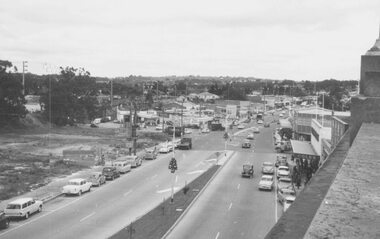
Photograph, Maroondah Highway West, Ringwood- 1962. Looking west from Town Hall
Black and white photograph (2 copies)Written on back of one photograph: "From Town Hall roof, Dec 1962. Image shows demolished site of Cool Stores on corner of Maroondah Highway and Wantirna Road. -
 Charlton Golden Grains Museum Inc
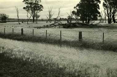
Photograph, Charlton Tribune, B/W photograph of 1971 flood, Nov 1971
B/W photograph of 1971 flood. Paddocks & roadside along Calder Highwayflood, charlton, calder highway -
 Ringwood and District Historical Society
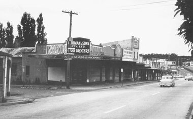
Photograph, Maroondah Highway Central, Ringwood. Corner Main Street & Adelaide St. looking east towards Warrandyte Road- 1966
History of the Norman Cash Grocery Stores. Normans started grocery store in Drummond Street Oakleigh in 1903 and expanded to 13 stores in adjacent suburbs, Ringwood being one of these. Photo is Norman & Sons P/L corner of Maroondah Highway and Adelaide Street.Black and white photograph (2 copies) Typed below one copy: "Corner Main Street & Adelaide St. looking east towards Warrandyte Road - 1966". Image shows Norman & Sons Grocer store on corner of Adelaide Street and Main Street. -
 Ringwood and District Historical Society
Photograph, Maroondah Highway West, Ringwood- c1920. Original Ringwood Market, Cnr. Maroondah Highway and Ringwood Street
Black and white photograph of wooden building. (2 copies)Typed under one copy: "Original Ringwood market and saleyards at corner of Maroondah Hwy and Ringwood St.. Charter St is beyond saleyards on right. SEC office now occupies site of buildings seen. c1920" Typed under second copy: "Original Ringwood market cnr Maroondah Highway and Ringwood St. opposite present clock tower site. 1920. Now SEC office. Sign on building reads- "Ringwood Market. D.G. McClelland & Co.. Stock Station Land Estate Agents. Alex McClelland, Auctioneer. -
 Ringwood and District Historical Society
Photograph, Maroondah Highway west, Ringwood- 1965. Easterly view towards Esso petrol station and cool stores on opposite corners of Wantirna Road
Black and white photographWritten beneath photograph, "1965 - Looking east to old cool store site." Written on rear of backing sheet, "1965. Cool store site, corner Maroondah Highway and Wantirna Road". -
 Ringwood and District Historical Society
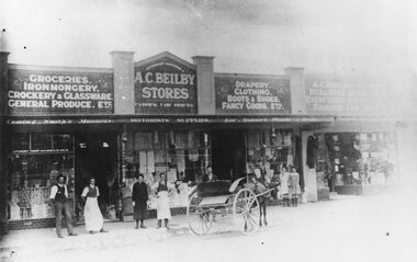
Photograph, Maroondah Highway Central, Ringwood. Shops in Main Street, c1925
Black and white photograph (2 copies)Typed below one photograph: "Maroondah Highway Ringwood. Shops opposite station entrance, c1925. Image shows people standing on pavement at front of Beilby Stores, and horse and cart on road. -
 Ringwood and District Historical Society
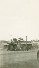
Photograph, Maroondah Highway Central, Ringwood. Laying water main in Main Street, 1935. Looking towards the east
Black and white photographImage shows excavator digging trench for water main on Main Road (Maroondah Highway. Towards the north-east, near the corner of Warrandyte Road. Bently's timber yard and Pratt's butcher. -
 Ringwood and District Historical Society
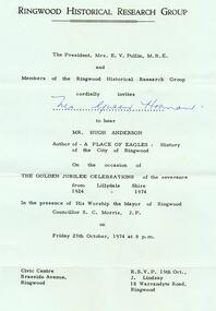
Photograph, Invitation from the Ringwood Historical Research Group on 25th October 1974. From the Ellie Pullin MBE and members of the RHRG to Mrs G Horman. To hear Hugh Anderson, author of the "Place of Many Eagles" at the Civic Centre, Maroondah Highway, Ringwood
Invitation from the Ringwood Historical Research Group on 25th October 1974. From the Ellie Pullin MBE and members of the RHRG to Mrs G Horman. To hear Hugh Anderson, author of the "Place of Many Eagles" at the Civic Centre, Maroondah Highway, Ringwood. All material is from Gwen Horman’s three albums that she owned.