Showing 2951 items matching "highways"
-
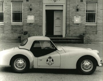 Victoria Police Museum
Photograph (police car)
Triumph TR3 highway patrol outside Bendigo police station. Circa 1960police vehicles; wireless patrol; motor transport branch; motor transport section; triumph tr3 car -
 Whitehorse Historical Society Inc.
Newspaper, Along the highway, 1992
A guide to business along the Maroondah Highway from Middleborough Road to Heatherdale Road.A guide to business along the Maroondah Highway from Middleborough Road to Heatherdale Road.A guide to business along the Maroondah Highway from Middleborough Road to Heatherdale Road.maroondah highway blackburn, pharmacies, maroondah highway mitcham, athan, savvas, maroondah highway nunawading, gelb, joe, mitcham shopping centre, regal kitchens, blackburn, nunawading fire station, armstrong, norman -
Whitehorse Historical Society Inc.
Article, The Maroondah Highway - past, present and future, 1/10/1970 12:00:00 AM
Supplement to C.R.B. News, 1970 giving detailed history and description of the Maroondah Highway.Supplement to C.R.B. News, 1970 giving detailed history and description of the Maroondah Highway.Supplement to C.R.B. News, 1970 giving detailed history and description of the Maroondah Highway.maroondah highway, whitehorse road, victoria. country roads board -
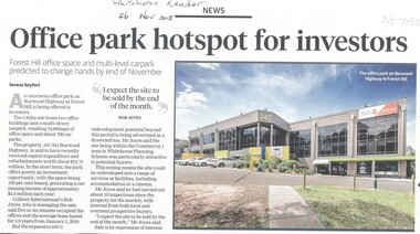 Whitehorse Historical Society Inc.
Article, Office Park Hotspot For Investors, 2018
An enormous office park on Burwood Highway in Forest Hill is being offered to investors.An enormous office park on Burwood Highway in Forest Hill is being offered to investors.An enormous office park on Burwood Highway in Forest Hill is being offered to investors.burwood highway, forest hill, no. 347 - 351 -
 Old School House Museum
Photograph
Copy of an older photo, Bay St (Nepean Highway) Frankston Adults and children -
 Brimbank City Council
Framed Colour Photograph, View of the city and highway from western suburbs 1985
Framed Colour Photograph - View of the city and highway from western suburbs 1985 -
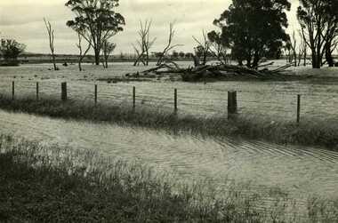 Charlton Golden Grains Museum Inc
Photograph, Charlton Tribune, B/W photograph of 1971 flood, Nov 1971
B/W photograph of 1971 flood. Paddocks & roadside along Calder Highwayflood, charlton, calder highway -
Lakes Entrance Historical Society
Book, Gardner, P D, Names on the Omeo Highway, 1991
Names on the Omeo Highway, Victoria, between Bairnsdale and Omeo; their origins, meanings and historysocial history, historic sites, land settlement -
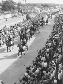 Ringwood and District Historical Society
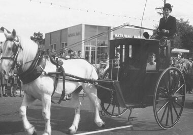
Photograph, Proclamation of Ringwood City celebrations 1960
Black and white photograph showing procession through Ringwood along Maroondah Highway.Typed below photograph: "Proclamation of Ringwood City celebrations, 1960. Old cool store site top left." Image shows Cobb & Co coach later smashed up in accident. -
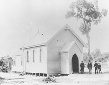 Ringwood and District Historical Society
Photograph, St Paul's Church, Whitehorse Road, Ringwood, Vic. circa 1910
St Paul's Church on Whitehorse RoadWritten on back of photograph, "St. Paul's on highway." -
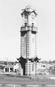 Ringwood and District Historical Society
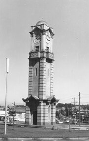
Photograph, Maroondah Highway West, Ringwood- 1974. Clocktower on new site
Black and white photographClocktower on corner of Maroondah Highway and Wantirna Road. -
 Ringwood and District Historical Society
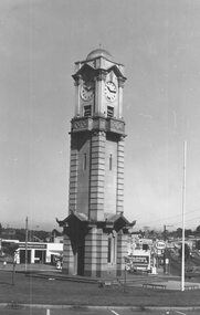
Photograph, Maroondah Highway West, Ringwood- 1974. Clocktower on new site
Black and white photographClocktower on corner of Maroondah Highway and Wantirna Road. -
 Ringwood and District Historical Society
Photograph, Maroondah Highway West, Ringwood- 1974. Clocktower on new site
Black and white photographClocktower on corner of Maroondah Highway and Wantirna Road. -
 Mt Dandenong & District Historical Society Inc.
Photograph
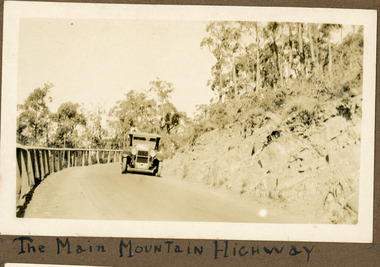
The photograph shows an old car rounding a bend on what is now the Mt Dandenong Tourist Road. Around 1930 it would have been called the CRB Road or the Main Road. The photograph is in the Ivy Child Album. Ivy May Child (1910 – 1989) was the daughter of Arthur Edward (Ted) Child (1878 – 1964) and Ethel May Madden (1888 – 1970). Ted Child was the son of Matthew Francis Child (1839 – 1933) and Martha Jeeves (1857 – 1926). He was the grandson of one of the early pioneers Francis Child. Ivy grew up on the family property on Childs Road and took many photographs. Most of these are glued into her photo album. The album covered the years from c1927 – 1932. Ivy married Henry William Burgess (1906 – 1968) in 1944.Sepia coloured photograph showing an old car rounding a bend in the road.Below photograph in album: The Main Mountain Highwaymain road, crb road mt dandenong tourist road, car, automobile, ivy child, kalorama -
 Lakes Entrance Historical Society
Postcard - Township, 1930c
Black and white small format postcard showing the township situated on the land between the Cunninghame Arm and North Arm. Lakes Entrance VictoriaLakes Entrance from Princes Highway (on back)bridges, township, topography, waterways -
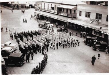
 Ringwood and District Historical Society
Photograph, City of Ringwood celebrations, 1960
Black and white photographHansom cab in procession along Maroondah Highway. -
 Victoria Police Museum
Photograph (police car), 1954
Passenger side of a Ford Customline, Highway Patrol, registration GDA 727, circa 1954police vehicles; transport branch; wireless patrol; motor police branch; motor traffic section; ford customline car; highway patrol -
 Victoria Police Museum
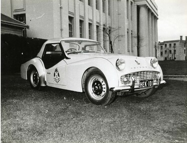
Photograph (police car)
Triumph TR3 Highway Patrol car registration number HEK-101. circa 1960police vehicles; wireless patrol; motor transport branch; motor transport section; highway patrol; triumph tr3 car -
 Ringwood and District Historical Society
Photograph, Maroondah Highway, Ringwood, looking east from Oban Road - 1999
Looking East along Maroondah Highway, near the corner of Oban Road in December 1999 -
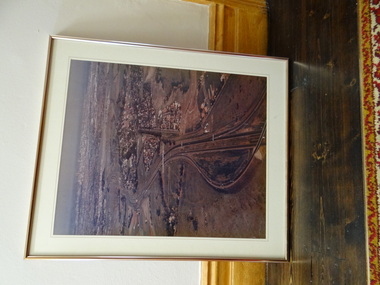
Whitehorse Historical Society Inc.
Map, Burwood Highway, c1970
Enlarged aerial photo of area South of Burwood Highway to Dandenong Creek, Vermont South.Enlarged aerial photo of area South of Burwood Highway to Dandenong Creek, Vermont South.Enlarged aerial photo of area South of Burwood Highway to Dandenong Creek, Vermont South.dandenong creek, morack road, vermont south, burwood highway, vermont south, aerial photographs -
Whitehorse Historical Society Inc.
Map, City of Nunawading, 1980?
Map of the City of Nunawading showing streets to south of Burwood Highway and east of Springvale Road.Map of the City of Nunawading showing streets to south of Burwood Highway and east of Springvale Road.Map of the City of Nunawading showing streets to south of Burwood Highway and east of Springvale Road.city of nunawading, historical -
Whitehorse Historical Society Inc.
Map, Springvale Road, 1968
Aerial photograph of cnr Springvale Road and Burwood Highway, south past Highbury Road.Aerial photograph of cnr Springvale Road and Burwood Highway, south past Highbury Road.Aerial photograph of cnr Springvale Road and Burwood Highway, south past Highbury Road.aerial photographs, highbury road, burwood east, burwood highway, burwood east, springvale road, burwood east -
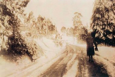 Mt Dandenong & District Historical Society Inc.
Photograph, Miss Perriman on Main Highway, Kalorama 1931, c1930
Back view of Miss Perriman walking along the Main Highway, Kalorama, in the snow in 1931.kalorama, snow, main highway, perriman -
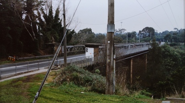 Kew Historical Society Inc
Photograph - Chandler Highway Bridge, Stewart West, 2001
Colour photograph by Stuart West of the Chandler Highway Bridge from the Fairfield side of the River.Nilchandler highway bridge, stewart west -
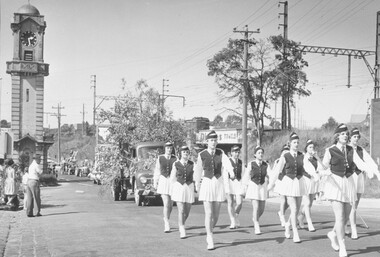 Ringwood and District Historical Society
Photograph, Scout Carnival, Ringwood- March 1959
Black and white photograph showing procession passing clocktower in Maroondah Highway. (2 copies)Written on back of photograph: "Scout Carnival - March 1959. Hampton Marching Girls leading procession." -
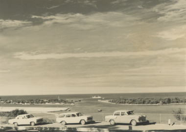 Lakes Entrance Historical Society
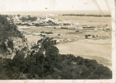
Photograph - Views from Jemmys Point, Lakes Entrance c1960, 1960 c
Black and white photograph of the entrance taken from a bend in the Princes Highway showing three cars parked at the viewing area beside the highway. Boat and dredge in waterway below highway dredged sand in Bullock Island extension, dredge Mathew Flinders working outside the entrance Lakes Entrance Victoria. Also two black and white photographs taken of Entrance from Jemmys Point taken 1960 c waterways, vehicles, islands, roads and streets -
 Whitehorse Historical Society Inc.
Photograph - Ariel Photograph, Tally Ho Office Park 1995, 1995
Aerial view of Tally Ho Office Park on corner of Springvale Road & Burwood Highway, East Burwood. Site partly developed. Shows East Burwood Reserve (part) and Bill Sewart Athletics Track. Photo taken facing Burwood Highway.lend lease development pty ltd, tally ho office park, springvale road burwood east, burwood highway burwood east, bill sewart athletic track -
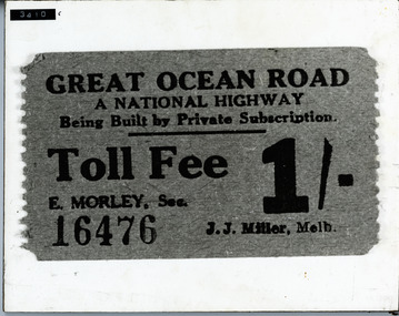 Lorne Historical Society
Photograph, G.O.R National Highway Private Subscription Toll fee ticket
Photograph National Highway private subscription toll fee for the G.O.R. Cost 1/- (one shilling)toll-fee: toll-ticket; g.o.r -
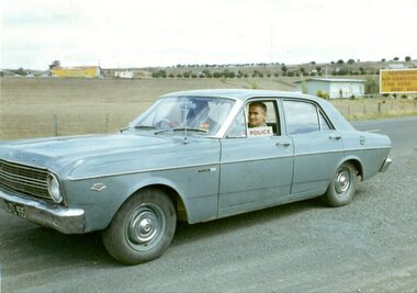 Victoria Police Museum
Photograph (police car)
Ford Falcon GT highway patrol vehicle, registration number JTL-935. Circa 1967police vehicles; motor transport branch; motor transport section; wireless patrol; highway patrol; ford falcon gt car -
Whitehorse Historical Society Inc.
Article, New park takes shape, 1986
Article about the development of Tally Ho Technology Park on corner of Burwood Highway and Springvale Road.Article about the development of Tally Ho Technology Park on corner of Burwood Highway and Springvale Road.Article about the development of Tally Ho Technology Park on corner of Burwood Highway and Springvale Road.tally ho industrial park, development