Showing 4549 items matching "historical maps"
-
 Ringwood and District Historical Society
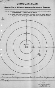
Plan of magazine site, Mines Dept, Explosives Magazine Licence and Maps, Wonga Rd Ringwood. 1940, 1936, 1938-1940
Plans for the magazine site in Ringwood, located at Wonga Road, Ringwood. Magazine licence 2 pages. Area map showing Warrandyte, Ringwood and Deep Creek. -
 Ringwood and District Historical Society
Pamphlet, Carter Real Estate, Carter & Son Pty Ltd Real Estate - Client newsletter 1995, Sep-95
Newsletter to clients including article related to the "Australia Remembers" celebrations.|The single page has ads for C.E. Carter and A.T. Miles plus The Mocha Cafe.3 A4 pages headed Client Newsletter - Carter & Son Pty Ltd Real Estate; Single photocopied page with ads and map +Additional Keywords: Carter, Richard / Miles, A.T. -
Ringwood and District Historical Society
Leaflet, Chris A. Moule, Auctioneer, Pamphlet produced for a builders realisation sale of lets in Manuela Terrace and Lyn Court Ringwood 1979, 1979
Pamphlet produced for a builders realisation sale of lets in Manuela Terrace and Lyn Court Ringwood 6th December 1979 in the "Bel-Air" Estate marked between Glenvale Road and Oban Road on diagrammatic map of Ringwood.Single page double-sided leaflet, black printing, front has red border. +Additional Keywords: Moule, C.A. -
Ringwood and District Historical Society
Land Title, Land Department, Titles, Maps: George Thomas Wiggin. Near Cnr Whitehorse Rd and New St Ringwood. 1917-1953
7 photocopied pages of land area maps and titles showing names of owners from 1917 to 1953 - copied in 2004 +Additional Keywords: Wiggin, George Thomas -
Ringwood and District Historical Society
Report, McAlpin, J.B, Report and valuation of land in Ringwood 1931, 23-Nov-31
Report and valuation of land in Ringwood in the name of David Bull EsqSingle page hand written report - valuation of land in Ringwood with area map. +Additional Keywords: McAlpin, J.B. / Bull, David -
Ringwood and District Historical Society
Map, Ringwood Croydon Mail, Map of East Ringwood with numbered sites of interest published by the Ringwood Croydon Mail for Ringwood Secondary College Fire Appeal Fund. 1993, 16-Sep-93
Map of East Ringwood with numbered sites of interest published by the Ringwood Croydon Mail as the major sponsor for Ringwood Secondary College Fire Appeal Fund. The school was extensively burnt in a fire in 1992 which destroyed classrooms, records, musical and sports displays.White sheet of paper with brown printing, A3, with marked locations for visiting. -
Ringwood and District Historical Society
Report, Ringwood Bypass and Suda-Larissa Avenue pedestrian crossing reports. 1992, 14-Jul-92
Brief notes and a locality map issued to local householders about a meeting to discuss the Suda-Larissa Avenue pedestrian crossing.Brief notes and a locality map issued to local householders about a meeting to discuss the Suda-Larissa Avenue pedestrian crossing. Report comprising three white A4 pages: two with typed notes and one of Ringwood Bypass notes. +Additional Keywords: Adams, Chris -
Ringwood and District Historical Society
Aerial Map, R.A.A.F, Aerial photograph of Mitcham and part of Ringwood (RAAF) 1931, 1931
Aerial photographs of Mitcham and part of Ringwood by RAAF 1931 with a covering explanatory text. The quality of the picture is poor as it is a copy of a paper copy. Page signed by Ken Baxter.1.Aerial photographs of Mitcham and part of Ringwood by RAAF 1931 - B&W.; 2. Text with explanations - white A4 page. +Additional Keywords: Baxter, Ken -
Ringwood and District Historical Society
Pamphlets, Council Annual Reports, 1956 to Ringwood Ratepayers and 1976 to Citizens of Ringwood, and Invitation to Maroondah Trade and Industry Development Group Luncheon, 1974, 1. 25-Oct-1974|2. Jan 1956|3. 3-Nov-1976
Three pamphlets relating to Ringwood's Development and notices to ratepayers.1. Invitation. Orange coloured bifold with black printing; 2. Report. White four page foolscap. Black printing. Borough Crest on front page.; 3. Report. Cream bifold with blue printing. Map with 5 photos. +Additional Keywords: Kelly, Alfred (Town Clerk) / Smart G.R.B. (Mayor)1.Trade and Industry development group - Maroondah.; 2. Ringwood Council Annual Report to the ratepayers.; 3. A report to the citizens of Ringwood. -
Ringwood and District Historical Society
Documents, City of Ringwood, Demographic profile of the City of Ringwood August 1989, 1960/1989/1991
During refurbishment of office in Civic Centre sent to VRDHS by Miranda de Giorgio, Community Liaison Officer 8-Dec-1993.Collection of documents about the City of Ringwood - civic centre.; 1. Demographic profile of the City of Ringwood August 1989.; 2. City of Ringwood - An Information Guide for Students- Nov 1991.; 3. Councillors names and addresses 5-Aug-1991; 4. Civic Centre - New Telephone Numbers; 5. City of Ringwood - Boundary Map; 6. City of Ringwood - 3 folders (2 coloured) 1960 +Additional Keywords: de Giorgio, Miranda -
Ringwood and District Historical Society
Draft a Booklet, Yarra Valley Church of England school building appeal 1964: Draft material, 1964
Proposed text, maps and pictures for a booklet about Yarra Valley Church of England school building appeal in 1964. Mock-up for school brochure. 10.pp. -
 Ringwood and District Historical Society
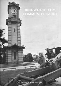
Book, Ringwood City Community Guide (1976-77), 1976
Ringwood Community Guide containing Council editorial, brief history of Ringwood, local Community Services and Business Listings. Also includes a street directory map of Ringwood Municipality, and a 1976-1977 Calendar."First Edition". "Front cover photograph: Memorial Clock Tower erected in 1928."rinx -
 Ringwood and District Historical Society
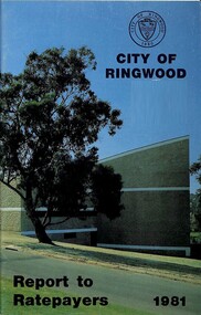
Booklet, Champion Press, City of Ringwood Report to Ratepayers 1981, 1981
Community booklet issued by City of Ringwood for 1981 - covering the facilities and activities of the Ringwood Council and other local organisations and associations. CONTENTS: (page number) Beautification and Leisure Areas 24 Building — General Information 21 Commissioners for Taking Declarations and Affidavits 15 Council Finance 11 Council Meeting Dates 5 Council Representation on various organisations 8 Councillors 6 Elections for Council 10 Emergency Telephone Numbers 51 Health -30 Home Help Service 22 Immunisation Programme 31 Infant Welfare Centres 33 Items of Interest 16 Justices of the Peace 14 Let's Be Neighbourly 20 Library — General 18 Library — Service for our Senior Citizens 23 Major Works 12 Map of municipality 26 Mayor's Message - Cr. F.J. Corr 4 Meals on Wheels 28 Members of Parliament 50 Officers of the Council 9 Proposed Leisure Centre 14 Rate Assistance 11 Rate Payments 10 Recycling Depots 49 Ringwood Cultural Centre 2 Ringwood Festival activities for 1981 29 Standing Committees of Council 5 Swimming Centre 13 Welfare and Community Services 34 rinx -
 Ringwood and District Historical Society
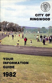
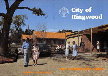
Booklet, City of Ringwood - Your Information Guide 1982, 1982
Community information booklet issued by City of Ringwood for 1982 - covering the facilities and activities of the Ringwood Council and other local organisations and associations. Cover photograph: A.C. Robertson Athletic Field. CONTENTS: (page no.) Beautification and Leisure Areas 16 Building — General Information 26 By-Laws 27 Circuit Bus — Ringwood City 54 Commissioners for taking Declarations and Affidavits 31 Council Meeting Dates 6 Council Representation 7 Councillors 4 Cultural Centre 32 Disabled Persons - Facilities 34 Elections for Council 10 Emergency Telephone Numbers 54 Festival 33 Finance — Council 12 Golf Course 30 Health Home Help Service 24 Immunisation Programme 20 Items of Interest 22 Justices of the Peace 30 Library — General 13 Library — Service for our Senior Citizens 26 Major Works Programme 14 Map of Municipality 28 Mayor's Message – Cr. N.J. Hamilton 2 Meals on Wheels 25 Members of Parliament 52 Officers of the Council 8 Property Records 10 Rates 11 Recycling Depots S3 Regulations 27 Roll — Municipal 10 Swimming Centre 21 Voting — Compulsory 10 Welfare and Community Services 35 rinx -
 Ringwood and District Historical Society
Booklet, City of Ringwood 1985 Information Guide, 1985
Community information booklet issued by City of Ringwood for 1985 - covering the facilities and activities of the Ringwood Council and other local organisations and associations. Cover photograph: Lionsbrae - Frail Aged Hostel.CONTENTS: (page no.) By-Laws/Traffic Regs. 35 Chief Executive 10 Children's Service 12, 13 & 40 Churches 41 City Map 32 & 33 Committees of Council 7 Community Services 38 Community Services Officer 43 Council Finances 24 Councillors 4 & 5 Council Meeting Dates 6 Council Representatives 8 Cultural Centre 23 Disabled Persons Facilities 44 Eastern Corridor 18 East Ringwood Shopping Centre 22 Emergency Telephone Nos. 63 Garbage Collection 20 Golf Course 15 Health 26 Historical Research Croup 47 Home Help 30 Hospitals 48 Immunisations 27 Incinerators 21 Infant Welfare Centres49 J.P.'s and Commissioners 37 Library 28 & 29 Lionsbrae 17 Management Executive 11 Mayoral Message – Cr. R. Gardini, J.P. 3 Meals on Wheels 34 North Ringwood Senior Citizens 16 Opportunity Shops 53 Parks and Reserves 53 Parliamentary Representatives 9 Playgroups 55 Pre-schools 56 Public Toilets 56 Rates 25 Ringwood Croydon Advisory Service 37 Schools 58 Senior Citizens Centres 60 Swimming Pool 14 Unemployment 62 Victoria's 150th Anniversary 36 Works Programme 18 & 19 Youth Outreach Worker 62 rinx -
 Ringwood and District Historical Society
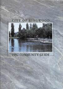
Book, City of Ringwood, City of Ringwood 1992 Community Guide, 1992
Community information book issued by City of Ringwood for 1992 - covering the facilities and activities of the Ringwood Council and other local organisations and associations. Includes two Aquatic Centre entry vouchers valid until June 30th, 1992.CONTENTS: (page no.) 1991/92 COUNCIL REPRESENTATIVES 4 1992 CALENDAR 51 AQUATIC CENTRE 8 AQUATIC CENTRE VOUCHERS 49 CHIEF EXECUTIVE'S REPORT 6 CIVIC CENTRE TELEPHONE INDEX — DIRECT DIALLING 53 COMMUNITY DIRECTORY 35-47 COMMUNITY SERVICES 17-19 COUNCIL & COMMITTEE CYCLES 4 COUNCIL FINANCES & 1991/92 RATES 16 COUNCILLORS 3 FUNCTIONAL RESPONSIBILITIES 15 HISTORY OF RINGWOOD 5 HOUSING & RESIDENTIAL DEVELOPMENT 29-30 INFRASTRUCTURE 34 LOCAL, STATE & FEDERAL GOVERNMENT ELECTIONS 32 MANAGEMENT TEAM 14 MAYORAL MESSAGE – Cr. Max Williams 1 NEIGHBOURHOOD MAP 26-27 NOTES 52 PAPER & CARDBOARD COLLECTION SERVICE 22 PARKS & RESERVES — PUBLIC FACILITIES 31 PROTECTING OUR COMMUNITY 23-24 PROTECTING THE ENVIRONMENT 20-21 RINGWOOD FESTIVAL & HIGHLAND CARNIVAL 13 RINGWOOD GOLF COURSE 7 STRATEGIC BIKE PLAN 11 STREET INDEX A-L 25 STREET INDEX L-Z 28 THE LIBRARY 12 THE RINGWOOD CONVENTION & PERFORMING ARTS CENTRE 10 TRAFFIC MANAGEMENT 33 YOUR PERSONAL DIRECTORY 50 rinx -
 Ringwood and District Historical Society
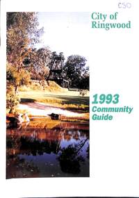
Book, City of Ringwood, City of Ringwood 1993 Community Guide, 1993
Community information book issued by City of Ringwood for 1993 - covering the facilities and activities of the Ringwood Council and other local organisations and associations. Includes two Ringwood Aquatic Centre bonus entry vouchers valid until June 30th, 1993. Cover photographs: Front - Poppet Head, Ringwood Lake; Back - Opening of North Ringwood Child Care Centre. CONTENTS: (page no.) Message from the Mayor – Cr. Greg Adkins, J.P. 3 Councillors 4 Council & Committee Cycle 5 Council Elections 6 History of Ringwood 7 Chief Executive's Report 8 The Management Team 9 Functional Responsibilities 10 Community Liaison 11 Council Expenditure for 1992/93 12 Rates and Valuations 13 COUNCIL SERVICES Community Services 14 Protecting the Environment 17 Protecting Our Community 19 Town Planning 21 Building 22 Design and Investigation 23 Works 24 Street Index - Electoral Wards 25 Neighbourhood Map 26 and 27 COUNCIL RECREAION AND LEISURE FACILITIES Ringwood Golf Course 29 Aquatic Centre 30 The Ringwood Convention Centre 32 Ringwood Library 34 Ringwood Recreation 35 Parks and Reserves 30 Community Directory 38-50 Community Information Data Bank 51 Aquatic Centre Vouchers 51rinx -
 Ringwood and District Historical Society
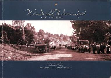
Book, Valerie Polley, Wonderful Warrandyte - A Portrait, 2014
Soft-covered book by Valerie Polley, Warrandyte Historical Society, featuring photographs, sketches and text outlining early and contemporary development of Warrandyte township and community, first published in April 2014.Front cover - Peace Day celebrations in Warrandyte, July 1919. Acknowledgements: The book project Wonderful Warrandyte-A Portrait was made possible by a grant under the Australian Government's 2012-2013 Your Community Heritage Program (Your Community Heritage - Sharing Community Heritage Stories). Several members of the Warrandyte Historical Society were involved in this book project which evolved after several years of development ideas. Valerie Polley wrote the text and selected photographs. Special thanks go to the Steering Committee of Margaret Kelly, Andy Bevan-Jones, Richard Morton and Wayne Rankin for their knowledgeable input and beneficial editing advice, Murray Houghton for his specialised historical knowledge and advice on further references, and Diane Baird for editing. The book would not have been possible without all the dedicated work of the Society's members, past and present, who have contributed to the Society's substantial archive. All proceeds from the sale of this book go to the Warrandyde Historical Society. Photographs: Stephen Reynolds, Austin Polley, Valerie Polley, Wayne Rankin, Ron Harris, Merv Naughton. Flora and Fauna photography by Nth Warrandyte, Osborne Peninsula, Landcare, Inc. Maps: Jock Macneish -
 Ringwood and District Historical Society
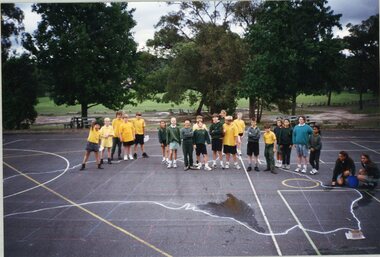
Photograph, Southwood Primary School - photograph of students on quadrangle with a large map of Australia drawn on the ground
photograph -
 Ringwood and District Historical Society
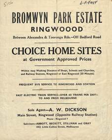
Flyer, Bromwyn Park Estate, Ringwood - 1946 - Avertising Brochures and Map
Two pages of subdivision features, services and locationSubdivision plan includes Alexandra Road, Marwarra Street, Tooronga Road, Hilary Grove, Morcom Avenue. -
 Ringwood and District Historical Society
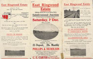
Flyer, Subdivisional Auction Sale Brochure, East Ringwood Estate, Vic. - 1923
Tri-folded double sided advertisement for subdivisional auction sale on Saturday, 1st December, 1923, including location map and summary of local facilities and services.Subdivision includes Patterson Street, Bona Street, Miller Grove, Fairview Avenue and Eastfield Road. Auctioneer - Phillips & Nicholson, 281 Collins Street, Melbourne. Tel. Central 10907. Agent - C.E. Carter, Main Street, Ringwood. Tel. Ringwood 24. -
 Ringwood and District Historical Society
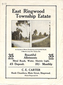
Flyer, Subdivisional Land Sale Brochure, East Ringwood Township Estate, Vic. - 1923
Bi-folded double sided land subdivision sale advertisement with location map and summary of local facilities and services. Includes two additional images of allotment plan with subsequent handwritten notations.Subdivision includes Mount Dandenong Road, Grey Street, and Eastfield Road. Agent - C.E. Carter, Bank Chambers, Main Street, Ringwood. Phone Ringwood 24. -
 Ringwood and District Historical Society
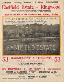
Flyer, Subdivisional Land Auction Sale Brochure, Eastfield Estate, Ringwood, Vic. - 1920
Bi-folded double sided land advertisement for subdivision auction on Saturday, December 11th, 1920, for Eastfield Estate with location map and summary of local facilities and services.Subdivision includes Croydon South streets - Eastfield Road, Long View Road, The Mount, and Pleasant Rise. Local Agent - Godbehear & Co, Phone Ringwood 49. -
 Ringwood and District Historical Society
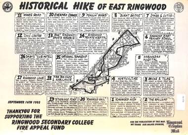
Document, Historical Hike of East Ringwood -1993
... Black and white laminated map Historical Hike of East Ringwood ...Black and white laminated mapMap includes 20 separate locations of historical interest around East Ringwood. Produced for the Ringwood Secondary College Fire Appeal Fund -September 16th 1993 -
 Ringwood and District Historical Society
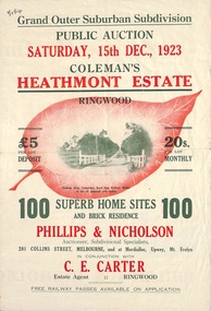
Flyer, Land Sale Brochure, Coleman's Heathmont Estate, Ringwood, Vic. - 1923
Bi-fold advertisement for auction sale of residential sites, including photographs, map, and summary of subdivision features and local facilities. Auction date Saturday 15th December, 1923. Subsequent auction date Saturday 19th January, 1924, following previous sale stopped on account of rain. Initial newspaper advertisement (publication unknown) dated 16/11/23.Subdivision includes Bedford Road, Canterbury Road, Alvena Crescent, Leonard Street (later Royal Avenue), and Coleman Street. Agent - Phillips & Nicholson, 281 Collins Street Melbourne, (Phone) Central 10907, in conjunction with C.E. Carter, Main Street, Ringwood. Tel. Ringwood 24. -
 Ringwood and District Historical Society
Flyer, Land Sale Brochure, Heathmont Estate, Vic. - circa 1960
Advertisement for sale of residential lots - Heathmont Estate, opposite Heathmont Railway Station, with map and locality plan.Subdivision includes Canterbury Road, Royal Avenue, Coleman Street, Stoda Street, Herman Street, and Campbell Street. Agent - A.W. Dickson, opposite Station, Ringwood. Phone WU6007. -
 Ringwood and District Historical Society
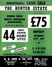
Flyer, Land Sale Brochure, The Hunter Estate, North Ringwood, Vic. - circa 1960
Bi-fold land sale advertisement for The Hunter Estate, North Ringwood, including terms of sale, area map, layout of the estate, and summary of local facilities and services, with separate attachment listing lot number prices.Subdivision includes Wonga Road, Hunter Avenue (later Graeme Avenue), Panfield Avenue, Hendra Grove, and Mullum Mullum Road. Agent - N.R. Reid & Co. Pty. Ltd., Station Entrance, Ringwood. (Phone) WU 6661. -
 Ringwood and District Historical Society
Flyer, Executor's Auction Subdivision Advertisement, Lilydale Road and Oban Road, Ringwood East, Vic. - 1937
Single page advertisement for Executor's Auction of land in Ringwood East on Saturday, May 29, 1937 with locality map showing 26 building sites for auction highlighted in brown, and brief summary of local services available. Subdivision includes Old Lilydale Road, Joseph Street, Dynes Street, Albert Street (later Wyrunga Street), Carcoola Road, and Mount Dandeong Road. (Carcoola Road incorrectly shown as Oban Road on the subdivision plan). Auctioneer - C.E. Carter, (Phone Ringwood 24. -
 Ringwood and District Historical Society
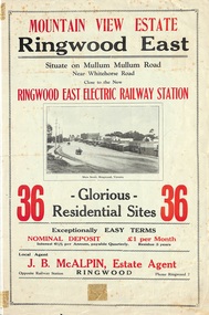
Flyer, Land Sale Brochure, Mountain View Estate, Ringwood East, Vic. - 1923
Bi-fold advertisement for sale of residential allotments, including photographs, map, and summary of subdivision features and local facilities. Undated handwritten notation reads "streets don't exist today".Subdivision layout includes Mullum Mullum Road, Rangeview Avenue, Press Avenue, and Mountview Avenue. Local Agent - J.B. McAlpin, Opposite Railway Station, Ringwood, Phone Ringwood 7. Vendor - T.J. Press, Builder, "Monterey", Second Avenue, Kew, Telephone Haw. 3428. -
 Ringwood and District Historical Society
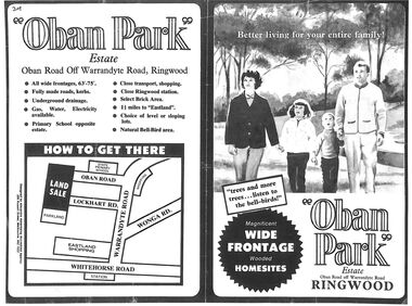
Flyer, Land Sale Advertisement, Oban Park Estate, Ringwood, Vic. - 1969
One double-sided and two single-sided pages advertising Oban Park Estate land sale, including terms of sale, locality map, subdivision features and summary of local services.Subdivision includes Oban Road, Terrigal Close, Dorelaw Drive (later Melview Drive), Naroo Court, Barook Court, and Lockhart Road. Agents in Conjunction: E. Wachman, Melbourne, Hutchinson Real Estate, Ashwood, and A.W. Dickson, 136 Whitehorse Road, Ringwood (Phone) 870-6007 A.H. 882967. Separate newspaper advertisement (digital only) shows agents - Hutchison Real Estate (Telephone 277-2326) and Michelson Gelfand Pty Ltd (Telephone 53-8151).