Showing 442 items matching "lands, victoria"
-
 Port Melbourne Historical & Preservation Society
Map, John Millar, "Design for Ship Canal or 'tidal harbor' and docks for the Port of Melbourne", 21 Sep 1860
COPYRIGHT STATE OF VICTORIA Hydrographic map. "Design for Ship Canal or 'tidal harbor' and docks for the Port of Melbourne". Shows proposed extension of the city westward. Signed 21.09.1860, lithographed 21.12.1860 and reproduced 1986transport - shipping, piers and wharves, engineering - canals and drainage, town planning -
 Bendigo Historical Society Inc.
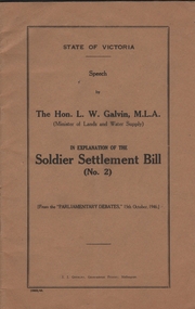
Book - SOLDIER SETTLMENT BILL (NO.2)
Twenty six pages booklet. State of Victoria - Speech by The Hon. L.W. Galvin M.L.A. (Minister of Lands and Water Supply) in Explanation ot the Soldier Settlment Bill (No. 2) from the Parliamentary Debates 15th October 1946.government, state, soldier settlment bill -
 Bendigo Historical Society Inc.
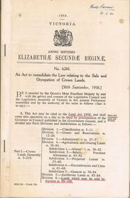
Book - 1958 VICTORIA ANNO TERTIO ELIZABETHÆ SECUNDÆ REGINÆ NO. 6284, 23/2/60
A small book owned by Accountant & Auditor Harold Curnow dated 23/2/60 detailing "An Act to consolidate the Law relating to the Sale and Occupation of Crown Lands." on page 61 it also has a 2/10/61 newspaper article and a June 27, 1962 page from the Victoria Gazette both of them detailing the Laws. The first page is written as following "Harold Curnow 1958. VICTORIA ANNO SEPTIMO ELIZABETHÆ SECUNDÆ REGINÆ No. 6284. An Act to consolidate the Law relating to the Sale and Occupation of Crown Lands, [30th September, 1958.] Be it enacted by the Queen's Most Execellent Majesty by and with the advice and consent of the legislative Assembly of Victoria in this present Parliament assmled and by the authority of the same as follows (that is to say) 1. This act may be cited as the Land Act 1958. and shall come into operation on a day to be fixed by proclamation of the Governor in council published in the Goverment Gazette, and is divided into Parts Divisions and Subdivisions as Follows:-"victoria -
 Bendigo Historical Society Inc.
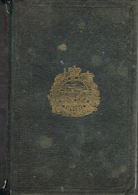
Book - DEPARTMENT OF AGRICULTURE SECOND ANNUAL REPORT 1874
Dark green cover, embossed on front 'Department of Agriculture Victoria' enclosed in circular design. Report to the Minister of Lands and Agriculture, 1874 on the proceedings of the Department, 363 pages. Written on front page in black ink "Mr H.P. Smith, Strathfieldsaye' Includes information on agricultural education, Australian grasses, diseases among stock, orange cuture, wood boring beetles, apples meteorologyof Victoria, worm diseased in sheep, sericulture, white eyebrowed woodswallow, flax, vines and wine industry, fencing and impounding. Contains information about Strathfieldsaye vigneron Messrs Bruhn and T Strachan of Axedale. Extensive metereological data for 1873 included; Sandhurst data described in depth.Variousgovernment, state, department of agriculture -
 Bendigo Historical Society Inc.
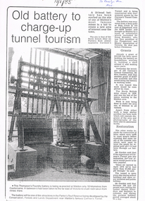
Newspaper - LONG GULLY HISTORY GROUP COLLECTION: 10 HEAD BATTERY
Copy of a newspaper article titled Old battery to charge-up tunnel tourism. Date written on the paper is 11/1/85. The Thompson's Foundry Battery was re-erected in the Parkin's Reef Reserve after being used at Bola Creek near the NSW border. A team of volunteers and a Grant had it moved to Maldon where it was set up and the area made attractive for tourists.bendigo, history, long gully history group, the long gully history group - 10 head battery, thompson's foundry battery, parkin's reef reserve, conservation forests and lands department, carman's tunnel, north british mine, parkins reef, carman's tunnel committee, dr doug kemsley, prospectors' and miners' association of victoria, mr ken garden -
Bendigo Historical Society Inc.
Document - HARRY BIGGS COLLECTION: OLD POLICE BARRACKS, 5/6/70
Document. Harry Biggs Collection. A letter on Public Works Department Victoria letterhead from G. Serpell Director General to Mr H. Biggs, Treasurer Royal Historical of Victoria (Bendigo Branch) dated 5th June 1970. In the letter he is stating The Depart. Of Crown Lands & Survey is investigating the future use & control of the old Police Barracks building.G. Serpell Director Generalorganization, club/society, community, harry biggs collection, old police barracks -
 Bendigo Historical Society Inc.
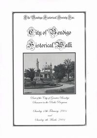
Book - CITY OF BENDIGO HISTORICAL WALK BOOK, 2001
Photocopy mock up of original booklet of The Bendigo Historical Society Inc. 'City of Bendigo Historical Walk' containing photographs of historic buildings to be seen on the walk. Front cover Queen Victorian Gardens, Town hall, Mechanics Institute/School Of Mines and Industry, H. M. Prison Bendigo, Camp Hill Police Barracks, Sandhurst Corporate High School, Central State School No. 1976, The Cascades, District Lands Office (Dudley House), Masonic Temple and Hall, Sandhurst Volunteer Rifle Brigade Orderly Room, Bank of Victoria, Henry Jackson's Store View Point,Alexandra Fountain, Beehive Store/Mining Exchange, Colonial Bank. Hustlers Royal Reserve NO. 2/R.S.L. Memorial Hall, Post Office 3rd 4th and final, Bendigo Law Courts, Shamrock Hotel 2nd and another view. Important Bendigo Dates; 1851, April gold discovered at Golden Square by Margaret Kennedy,1851 Approx. 200,000Troy oz. of gold found in Bendigo, 1852 475,857 Troy oz. Gold for the year, 1853 November 31st Bendigo Hospital admits first patient,1853 December 9th Bendigo Advertiser first issue printed, 1854 First Land Sales and streets are surveyed and named for the first time, 1854 Census of Bendigo showed 15,480 residents plus 4,000 Chinese, 1855 Sandhurst Municipal District formed, 1861 Sandhurst Proclaimed a Town. 1862 Railway to Melbourne opened, 1867 Visit by His Royal Highness the Duke of Edinburgh, 1871 July 21st Sandhurst proclaimed a City, 1881 Population of Sandhurst 14,577 residents, 1882 First telephone communications introduced, 1890 Electric trams (battery) commenced running, 1891 May 18th City of Sandhurst changes its name to City of Bendigo.book, bendigo, buildings, historic -
 Bendigo Historical Society Inc.
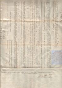
Document - TOWN LOT GRANT BY PURCHASE TO FREDERICK TAYLOR, 1854
Town Lot Grant by Purchase to Frederick Taylor. Enrolled in the office of the registrar of the Supreme Court of the Colony of Victoria in Register, Town Purchases Victoria Folio 27 No. 27 this twenty-fifth day of September 1854. Colony of Victoria crest/seal. Witness our trusty and well beloved Sir Charles Hothamorganization, lands and survey, town lot grant purchase -
 Bendigo Historical Society Inc.
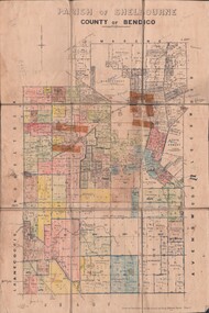
Map - JACK FLYNN COLLECTION: SHELBOURNE, 11/02/1937
... and Reproduced at the Dept, of Lands and Survey, Melbourne, Victoria...., Government Printer. Drawn and Reproduced at the Dept, of Lands ...Map: Parish of Shelbourne, County of Bendigo. Parish plan.By Authority, H. J.Green, Government Printer. Drawn and Reproduced at the Dept, of Lands and Survey, Melbourne, Victoria.map, bendigo, parish plan, shelbourne -
 Bendigo Historical Society Inc.
Map - JACK FLYNN COLLECTION: TOWNSHIP OF STANHOPE, December 1950
... . Drawn and Reproduced at the Dept, of Lands and Survey, Melbourne... Printer, Melbourne. Drawn and Reproduced at the Dept, of Lands ...Map: Township of Stanhope, Parish of Girgarre, County of Rodney. Parish plan.By Authority J. J. Gourley, Government Printer, Melbourne. Drawn and Reproduced at the Dept, of Lands and Survey, Melbourne, Victoria.map, rodney, township, stanhope -
 Bendigo Historical Society Inc.
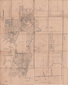
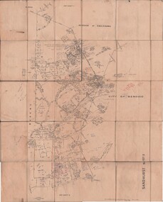
Map - JACK FLYNN COLLECTION: SANDHURST SHEET 6, January 1947
... . Drawn and Reproduced at the Dept, of Lands and Survey, Melbourne..., of Lands and Survey, Melbourne, Victoria. Map: Parish of Sandhurst ...Map: Parish of Sandhurst Sheet 6. County of Bendigo. Parish plan.By Authority J. J. Gourley, Government Printer, Melbourne. Drawn and Reproduced at the Dept, of Lands and Survey, Melbourne, Victoria.map, bendigo, parish plan, sandhurst sheet 6 -
 Bendigo Historical Society Inc.
Map - JACK FLYNN COLLECTION: SANDHURST SHEET 2, January 1947
... . Drawn and Reproduced at the Dept, of Lands and Survey, Melbourne..., of Lands and Survey, Melbourne, Victoria. Map: Parish of Sandhurst ...Map: Parish of Sandhurst Sheet 2, County of Bendigo. Parish plan.By Authority J. J. Gourley, Government Printer, Melbourne. Drawn and Reproduced at the Dept, of Lands and Survey, Melbourne, Victoria.map, bendigo, parish plan, sandhurst sheet 2 -
 Bendigo Historical Society Inc.
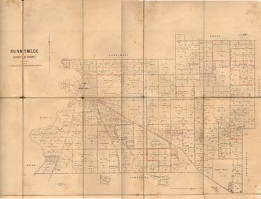
Map - JACK FLYNN COLLECTION: RUNNYMEDE, June 1946
... . Drawn and Reproduced at the Lands and Servey, Melbourne..., Government Printer, Melbourne. Drawn and Reproduced at the Lands ...Map: Parish of Runnymede, County of Rodney. Parish plan.By Authority: J.J. Goourley, Government Printer, Melbourne. Drawn and Reproduced at the Lands and Servey, Melbourne, Victoria. June, 1946.map, rodney, parish plan, runnymede -
 Bendigo Historical Society Inc.
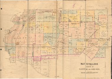
Map - JACK FLYNN COLLECTION: NATTE YALLOCK, 22/06/1937
... and Reproduced at the Depart., of Lands and Survey, Melbourne, Victoria....., of Lands and Survey, Melbourne, Victoria. Map: Parish of Natte ...Map: Parish of Natte Yallock, Counties of Gladstone and Kara Kara. Parish plan.By Authority H.J. Green Government Printer Melbourne. Drawn and Reproduced at the Depart., of Lands and Survey, Melbourne, Victoria.map, gladstone, parish plan, natte yallock -
 Bendigo Historical Society Inc.
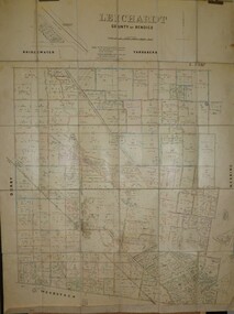
Map - JACK FLYNN COLLECTION: LEICHARDT, 14/03/1`939
... Drawn and Reproduced at the Dept, of Lands and Survey..., of Lands and Survey, Melbourne, Victoria. 14.3.1939 Map: Parish ...Map: Parish of Leichardt, County of Bendigo. Parish plan.Drawn and Reproduced at the Dept, of Lands and Survey, Melbourne, Victoria. 14.3.1939map, bendigo, parish plan, leichardt -
 Bendigo Historical Society Inc.
Map - JACK FLYNN COLLECTION: HAYANMI, March 1953
... and reproduced at the Dept, of Lands and Survey, Melbourne, Victoria... Printer. Drawn and reproduced at the Dept, of Lands and Survey ...Map: Parish of Hayanmi, County of Bendigo. Parish plan.By Authority: W.M. Houston, Government Printer. Drawn and reproduced at the Dept, of Lands and Survey, Melbourne, Victoriamap, bendigo, parish plan, hayanmi -
 Bendigo Historical Society Inc.
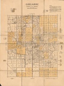
Map - JACK FLYNN COLLECTION: GIRGARRE, 14/10/1943
... and Reproduced at the Dept, of Lands and Survey, Melbourne, Victoria..., of Lands and Survey, Melbourne, Victoria Map: Parish of Girgarre ...Map: Parish of Girgarre , County of Rodney. Parish plan. Same map as 10100.20 but in poorer condition.By Authority, H.E.Daw, Government printer Melbourne. Drawn and Reproduced at the Dept, of Lands and Survey, Melbourne, Victoriamap, rodney, girgarre, girgarre, county of rodney -
 Bendigo Historical Society Inc.
Map - JACK FLYNN COLLECTION: GIRGARRE, 14/10/1943
... and produced at the Dept of Lands and Survey, Melbourne, Victoria... at the Dept of Lands and Survey, Melbourne, Victoria. 14.10.1943 Map ...Map: Parish of Girgarre. County of Rodney. Parish plan.By Authority, H.E. Daw, Government Printer Melbourne. Drawn and produced at the Dept of Lands and Survey, Melbourne, Victoria. 14.10.1943map, rodney, parish plan, girgarre, county of rodney -
 Bendigo Historical Society Inc.
Map - JACK FLYNN COLLECTION: ECHUCA NORTH, November 1953
... and Reproduced at the Dept., of Lands and Survey Melbourne, Victoria..., Government Printer. Drawn and Reproduced at the Dept., of Lands ...Map: Echuca North, County of Rodney. Parish plan.By Authority: W.M. Houston, Government Printer. Drawn and Reproduced at the Dept., of Lands and Survey Melbourne, Victoria. November 1953map, rodney, parish plan, echuca north rodney -
 Bendigo Historical Society Inc.
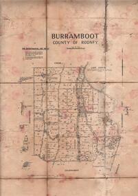
Map - JACK FLYNN COLLECTION: BURRUMBOOT, August 1951
... . Drawn and Reproduced at the Dept of Lands and Survey, Melbourne... of Lands and Survey, Melbourne, Victoria. August 1951 Map: Parish ...Map: Parish of Burrumboot, County of Rodney. Parish plan.By Authority J.J. Gourley, Government Printer Melbourne. Drawn and Reproduced at the Dept of Lands and Survey, Melbourne, Victoria. August 1951map, rodney, parish plan, burrumboot, rodney -
 Bendigo Historical Society Inc.
Map - JACK FLYNN COLLECTION: ARCHDALE, 15/01/1936
... . Drawn and Reproduced at the Dept, of Lands and Survey, Melbourne..., of Lands and Survey, Melbourne, Victoria. 15/01/36 Map: Parish ...Map: Parish of Archdale, County of Gladstone. Parish plan. The Allotments have been coloured in with pencil.By Authority H.J. Green, Government Printer Melbourne. Drawn and Reproduced at the Dept, of Lands and Survey, Melbourne, Victoria. 15/01/36map, gladstone, parish plan, archdale , gladstone -
 Bendigo Historical Society Inc.
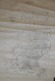
Map - JACK FLYNN COLLECTION: HUNTLY, August 1954
... and Reproduced at the Dept, of Lands and Survey, Melbourne, Victoria... Printer. Drawn and Reproduced at the Dept, of Lands and Survey ...Map: Parish of Huntly, County of Bendigo. Parish plan.By Authority W.M. Houston, Government Printer. Drawn and Reproduced at the Dept, of Lands and Survey, Melbourne, Victoria. August 1954.map, bendigo, parish plan, huntly -
 Bendigo Historical Society Inc.
Map - JACK FLYNN COLLECTION: GOORNONG, August 1953
... and Reproduced at the Dept., of Lands and Survey, Melbourne, Victoria... Printer. Drawn and Reproduced at the Dept., of Lands and Survey ...Map: Township of Goornong, Parish of Goornong, County of Bendigo. Parish plan.By Authority W.M. Houston. Government Printer. Drawn and Reproduced at the Dept., of Lands and Survey, Melbourne, Victoria. August 1953map, bendigo, township, goornong -
 Bendigo Historical Society Inc.
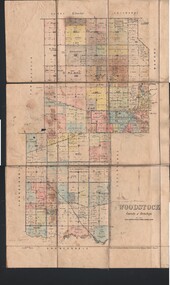
Map - JACK FLYNN COLLECTION: WOODSTOCK, 4/07/1935
... at the Dept of Lands and Survey, Melbourne Victoria. 4.7.35... Printer. Drawn and Reproduced at the Dept of Lands and Survey ...Map: Parish of Woodstock, County of Bendigo. Parish plan.By Authority H.J. Green. Govt Printer. Drawn and Reproduced at the Dept of Lands and Survey, Melbourne Victoria. 4.7.35map, bendigo, parish plan, woodstock -
 Bendigo Historical Society Inc.
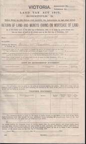
Document - KELLY AND ALLSOP COLLECTION: VICTORIA LAND TAX ACT 1910 - FORM, 31/12/1910 to 01/03/1911
Document. KELLY & ALLSOP COLLECTION. Three copies of Schedule B of Land Tax Act of Victoria 1910. 'Return of Land and Monies Owing on Mortgage of Land.' Each form partly filled out by Arthur Allsop in pencil, ie 'Particulars of Land' section. He owns two houses in Wills St and a vacant block of land at Pyke/Brodie Streets. Instructions to taxpayers 'Every owner of land must furnish a return before 1st March 1911 of all lands owned on 31 Dec 1910.'Taxation Office of Victoriabusiness, stockbroker, kelly & allsop, kelly & allsop collection, victoria land tax act 1910, schedule b -
Bendigo Historical Society Inc.
Map - VICTORIA, Circa 1926
Map: Map showing Counties, including Railway lines and Geographic features. Compiled and engraved at the Department of Lands and Survey Melbourne, Revised October 1926 ( number 184 in Map Cupboard 1)map, victoria, counties, counties of victoria, geographic features -
 Victorian Interpretive Projects Inc.
Photograph - Colour, Clare Gervasoni, Ebenezer Mission, Antwerp, 2013, 2013
The Ebenezer Mission Station is situated by the Wimmera River and was established by Moravian missionaries as the Lake Hindmarsh Aboriginal Reserve in 1859. At its peak more than 100 people lived and worked on the mission in more than 20 buildings. The Mission closed in 1900 and was returned to the Lands Department in 1904. The church was established in the 1870s and the cemetery includes hundreds of unmarked burials. In 1961 the National Trust (Victoria) received a letter from the Horsham Historical Society expressing concern for the future of the Mission buildings. By 1971 the National Trust was managing the site. It was fenced, connected to power and the church was restored. In the mid-1970s the gravestones were in a bad state of repair. Stonemason James McCauley worked on the stones for 2 weeks. In 1991 the church was handed over to the Goolum Goolum Aboriginal Co-operative to manage. On 05 December 2013 the National Trust handed over the freehold of the Mission site. Moravian missionary Revd Paul Bogisch and his wife Amalie are buried in the cemetery. A number of colour digital photographs showing buildings on the former Ebenezer Mission at Antwerp.ebenezer, bogisch, goolum goolum, goolum, national trust, national trust (victoria), lake hindmarsh, lake hindmarsh aboriginal reserve, moravian, mission, missionary -
 St Kilda Historical Society
Photograph - Photo map, 28/01/1951
One of a series of photo-maps produced for the Department of Crown Lands and Survey (1857-1983). For correlation with a current map, and access to other historical photo maps of Victoria, see the Historic Photo-Maps Index published by the Department of Environment, Land, Water and Planning at https://services.land.vic.gov.au/DELWPmaps/historical-photomaps/Black and white aerial photograph1424-45 SECRET 534 Run 18 Lens 12" Melbourne Metropolitan 12150 28.1.51 M639albert park, st kilda junction, st kilda pier, catani gardens, st kilda, prahran, albert park lake, 1951, middle park, st kilda beach, windsor -
 St Kilda Historical Society
Photograph - Photo map, 17/01/1951
One of a series of photo-maps produced for the Department of Crown Lands and Survey (1857-1983). For correlation with a current map, and access to other historical photo maps of Victoria, see the Historic Photo-Maps Index published by the Department of Environment, Land, Water and Planning at https://services.land.vic.gov.au/DELWPmaps/historical-photomaps/Black and white aerial photograph1414-21 538 Run 19 Lens 12" Melbourne Metropolitan 12150 17.1.51 M586st kilda, st kilda botanical gardens, peanut farm, elwood, 1951, point ormond, elwood canal, st kilda beach -
 St Kilda Historical Society
Photograph - Photo map, 28/01/1951
One of a series of photo-maps produced for the Department of Crown Lands and Survey (1857-1983). For correlation with a current map, and access to other historical photo maps of Victoria, see the Historic Photo-Maps Index published by the Department of Environment, Land, Water and Planning at https://services.land.vic.gov.au/DELWPmaps/historical-photomaps/Black and white aerial photograph1424-118 534 Run 20 Lens 12" Melbourne Metropolitan 12150 18.1.51M639elwood, point ormond, elwood park, elsternwick park, elwood beach, 1951