Showing 174 items
matching lands and survey department bendigo
-
 Bendigo Historical Society Inc.
Map - PANNOOBAMAWM : COUNTY OF BENDIGO, 1957
Map. Pannoobamawm, County of Bendigo, Terrick Terrick East, Wanurp, Pannoomilloo, Bamawm, Turrumberry, property allotments. Drawn and reproduced at the Department of Lands and Survey, 1957, Price 2/-. (number 410 in Map Cupboard 1 ).W.M. Houston, Government Printer, Melbourne.bendigo, hospital -
Bendigo Historical Society Inc.
Map - NERRING : COUNTY OF BENDIGO, August 1952
Map. Nerring, County of Bendigo, Leichardt, Marong, Sandhurst, Huntly, Neilborough, Yarraberb. Drawn and Reproduced at the Department of Lands and Survey, Melbourne, Victoria, August 1952, Price 2/-.( number 409 in Map Cupboard 1).J.J. Gourley, Government Printer, Melbourne.bendigo, hospital -
 Bendigo Historical Society Inc.
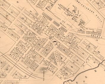
Map - MARKS COLLECTION: MAP SANDHURST 1867
Original map: Sandhurst 1867, shows central Bendigo and surrounds, including police camp, stockade, 'old cemetery', reserve for. On bottom of map: 'Lithographed at the Department of Lands and Survey by D. Henderson, 20 February, 1867'. On top RH corner 'Sheet No 1 Sandhurst'.map, bendigo, 1867 sandhurst map -
 Bendigo Historical Society Inc.
Document - NEVILLE KING COLLECTION: OCCUPATION CERTIFICATE HOMESTEAD FARM NO. 15/939 IN THE NAME OF DAVID WILLIAMS AT A COST OF ONE POUND, DATED 25 SEPTEMBER 1897, 1897
Under the Western Australia 'the Homestead act 1893' an Occupation Certificate, Homestead Farm No. 15/939 for David Williams of Bendigo for 160 acres (near Woolkabunning near Bunbury WA); at a cost of one pound. Signed by order of the Commissioner of Crown Lands. Dated 25 September 1897. The land is marked and distinguished in the maps and books of the Department of Lands and Surveys of the said (WA) Colony as Williams Location No. 702. -
 Bendigo Historical Society Inc.
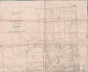
Map - MAP. HUNTLY. COUNTY OF BENDIGO, 1912
Map. Huntly. County of Bendigo. Wellsford. Bagshot. Nerring. Wirrakee. Sandhurst. Photo-lithographed at the Department of lands and Survey. Melbourne byW. J. Butson -
 Bendigo Historical Society Inc.
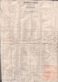
Map - MAP. WARRAGAMBA. COUNTY OF BENDIGO, 1915
Map. Warragamba. Colunty of Bendigo. Pannoomilloo. Minto. Diggorra. Kamarooka Photographedat the Department of LANDS AND Survey Melbourne by W. J. Butson. -
 Bendigo Historical Society Inc.
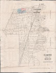
Map - MAP. ELMORE COUNTY OF BENDIGO, 1918
Map. Elmore County of Bendigo. Diggorra. Burnewang. Ryunnymead. Egerton Photo-Lithographed at the Department of lands and Survey Melbourne, by W. J. Button. 4.7.18 -
 City of Greater Bendigo - Civic Collection
Instrument - Gunter Chain, not known
Gunter's chain (also known as Gunter’s measurement) is a distance measuring device used for surveying. It was designed and introduced in 1620 by English clergyman and mathematician Edmund Gunter (1581–1626). It enabled plots of land to be accurately surveyed and plotted, for legal and commercial purposes. The provenance of this particular Gunter Chain is unknown but it is believed to be used either by the City of Bendigo / Sandhurst or the Lands Department locally when measuring and laying out plots and streets locally. A 66-foot (20.1 m) chain divided into 100 links, marked off into groups of 10 by brass rings or tags. Each link is 7.92 inches (201 mm) long. A quarter chain, or 25 links, measures 16 feet 6 inches (5.03 m) also called a a rod (or pole) measure. Ten chains measure a furlong and 80 chains measure a statute mile. city of greater bendigo surveying -
 City of Greater Bendigo - Civic Collection
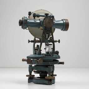
Instrument - Theodolite, Cooke, Troughton & Simms, c 1940
... Lands and Survey Department Bendigo... Lands and Survey Department Bendigo Cooke, Thoughton & Simms Ltd ...Theodolites are a highly accurate instrument that measures angles between designated visible points in the horizontal and vertical planes. The theodolite has a long history, with the term first found in 1571 in a surveying textbook 'A geometric practice named Pantometria' by Leonard Digges. (source https://en.wikipedia.org/wiki/Theodolite). Cooke Troughton & Simms began when John Troughton starting selling products in Fleet Street, London in 1782. He went into partnership with his brother Edward in 1807 who expanded the business considerably. William Simms, a former apprentice with the company was taken as a partner and then manager after Edward died in 1835 and the company became Troughton & Simms. By 1887 the company was able to produce all the parts necessary for their instruments and the company employed nearly 200 people and was one of the most well respected firms of instrument makers of the 1800's. James Simms, son of William who had inherited the company died in 1915 and the company was turned into a limited liability company by his two sons William and James. Things however were not so easy for the two sons and in 1922 the business was brought out by their rival T. Cooke & Sons becoming Cooke, Troughton & Simms. Theodolites are used by surveyors as part of their everyday work and although there is no specific information regarding the provenance of this particular one it is assumed it was used locally by the City of Bendigo and / or the Lands Department.A grey theodolite no 39161 made by Cooke, Thoughton & Simms. Various moving parts showing signs of extensive use particularly on the uprights on the main body and around knobs and dials where the paint is worn back to brass.Cooke, Thoughton & Simms Ltd / York. England / No 39161. Sticker; DPS - Asset No / (barcode) / 0010173city of greater bendigo administration item, lands and survey department bendigo -
 City of Greater Bendigo - Civic Collection
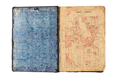
Administrative record - Land Sales, A. J. Mullet Government Printer et al, 1927
This type of album was made by agents auctioning and selling land.Large portfolio style album with dark green / black cloth cover bound with three large metal pins. Forty eight pages with twenty seven Department of Lands and Survey maps and newspaper clippings about land sales and auction details pasted in. Index page. Maps have handwritten notes and markings throughout in pencil and pen. Covers the County's of Gunbower and Tatchera. Includes a receipt slip with hand written notes on reverse on William Wallace & Co letterhead. city of bendigo commerce -
 City of Greater Bendigo - Civic Collection
Administrative record - Land Sales, Department of Lands and Survey et al, 1929
This type of album was created by agents auctioning and selling land.Large portfolio style album with green cloth cover bound with three large metal pins. One hundred and then pages with thirty three Department of Lands and Survey maps pasted in. Index page. Maps have handwritten notes and markings throughout in pencil and pen. Covers the Counties of Bendigo, Rodney, Talbot, Gunbower, Gladstone, Tatchera and Karkarooc, Shires of East Loddon and Huntly and Swan Hill District. -
 City of Greater Bendigo - Civic Collection
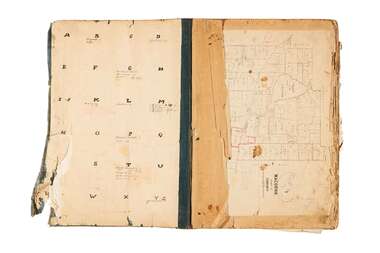
Administrative record - Land Sales, A. J. Mullet Government Printer, 1927
This type of album was created by agents auctioning and selling land.Large portfolio style album with black cloth cover bound with three large metal pins. Blue marbled pastedown endpapers. Seventy nine pages, seventy five with Department of Lands and Survey maps attached. No index page. Maps have handwritten notes and markings throughout in pencil and pen. Covers the Counties of Bendigo, Rodney, Gladstone and Talbot and Parishes of Kerang, Salisbury, Mandurang and Tarnagulla. Includes a hand written note on William Wallace & Co letterhead. city of bendigo commerce -
 City of Greater Bendigo - Civic Collection
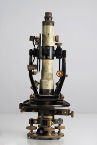
Instrument - Theodolite, E. R. Watts & Sons, c 1930
... Lands and Survey Department Bendigo... and Survey Department Bendigo Shire of Marong Watts & Sons / London ...Theodolites are a highly accurate instrument that measures angles between designated visible points in the horizontal and vertical planes. The theodolite has a long history, with the term first found in 1571 in a surveying textbook 'A geometric practice named Pantometria' by Leonard Digges. (source https://en.wikipedia.org/wiki/Theodolite). Theodolites are used by surveyors as part of their everyday work and although there is no specific information regarding the provenance of this particular one it is assumed it was used locally by the Shire of Marong and / or the Lands Department. Edwin Watts started the company in 1856, trading up to 1920s as E.R. Watts & Son with E. R. Watts & Son Ltd amalgamating with Adam Hilger Ltd to form Hilger & Watts in 1948.0442.1 A black and grey theodolite no 39161 made by Watts & Sons. Various moving parts showing signs of extensive use particularly on the uprights on the main body and around knobs and dials where the paint is worn back to brass. Is housed in original box with key, oil container and pin. 0442.2 handwritten instructions for making adjustments to the Theodolite written on the back of Road Users' Association of Victoria letterhead note paper.Watts & Sons / London / 5974 For N H Seward / Melbournelands and survey department bendigo, shire of marong -
 Bendigo Historical Society Inc.
Document - REPORT FROM THE SELECT COMMITTEE UPON THE CLAIMS OF HENRY FRENCHAM, 1890
( x ref 5673 , 8235 , Box 83 , 9077 ) Reports from the Gold Enquiry Select Committee from September 4th 1890 - 23rd October, including a list of witnesses, Minutes of Evidence 11th September 1890, 18th September 1890 and 25th September 1890; also, Appendices A - T, and also a location map drawn from memory by W. (William) Sandbach 18th Sep 1890 and Lithographed at the Department of Lands and Survey Melbourne by S. B. Bonney 28th October 1890. This enquiry covers the opinions of Robert Atkinson, Henry Frencham and Robert Francis Walker in relation to who was the first person to locate gold in the Bendigo field. Members of the Committee were Mr Bailes, in the chair, Mr Burrowes, Mr Cameron, Mr A, Young, Mr Gordon, and Mr Foster. Other name at the enquiry were, David Dunlop, John Paton, William Steward, Christian Asquith, James Graham, Ben. Bannister, Mr Fenton, T. J. Rossiter, P. P. Farrell, Thomas Robinson. Other persons who had made claims were; Patrick Peter Farrell, Frederich Fenton, Mrs. Margaret Kennedy, William Henry Johnson, Edward Pepperell, Henry Byass, William Sandbach, William Steward, Mrs John Barnett, widow of Christian Asquith's son, Robert Francis Walker, David Dunlop, John Paton.gold enquiry, henry frencham, gold discovery, david dunlop, john paton, william steward, christian asquith, james graham, ben. bannister, mr fenton, t. j. rossiter, p. p. farrell, patrick peter farrell, frederich fenton, mrs. margaret kennedy, william henry johnson, edward pepperell, henry byass, william sandbach, mrs john barnett, thomas robinson -
 Bendigo Historical Society Inc.
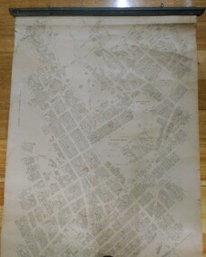
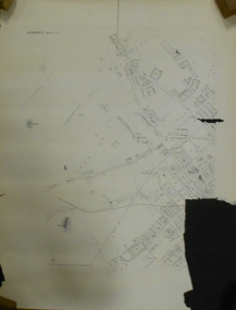
Map - MAP: BENDIGO SHEET 2, 1910, 1910
Map. Map with timber ends, showing names of property owners. Bendigo from Olinda Street west to Prouses Road and Bennet / Wattle Street to Dooley Street in the north. Copy of map taken for research purposes. Map prepared by Department of Lands and Survey, Melbourne by T.F. McGauran 4.1.10 (1910)map, bendigo, residence areas, 1910 -
 Bendigo Historical Society Inc.
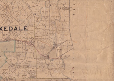
Map - Parish of Strathfieldsaye
Map owned by Henry Thomas (Jack) Qualtrough who worked for the Victorian Forestry Commission. Shire of Strathfieldsaye County of Bendigo canvas backed map. L5169. Includes Axedale, Kimbolton, Eppalock and Sedgewick. Photographed/Lithographed for the Department of Lands and Survey Melbourne by T E McGauran 24.3.07. Price 1/-.map, axedale, kimbolton, sedgewick, eppalock -
 Bendigo Historical Society Inc.
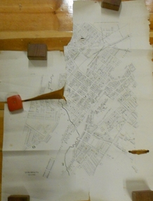
Document - MARKS COLLECTION: PLAN OF SANDHURST CITY CENTRE AND SURROUNDING AREA ( NO. 1 )
Plan on heavy parchment - section neatly cut out of area now Kennington. Written on plan in black print ' Sheet No. 1. Sandhurst'. Plan shows Government Camp, Commissioner's Gully, old cemetery site, manure depot, cattle market, Benevolent Asylum Reserve, railway reserve. Landowners' names on allotments. On bottom lithographed at the Department of Lands and Survey, Melbourne, by D. Henerson, March 12th., 1867 Plan part of George Lansell, Fortuna auction, documents found in wardrobe purchased by Marks family in 1930's.bendigo, planning, sandhurst 1867 -
 Bendigo Historical Society Inc.
Document - MARKS COLLECTION: PLAN OF SANDHURST CITY CENTRE AND SURROUNDING AREA ( NO. 2 )
Plan drawn on heavy parchment. Written on plan Sandhurst Sheet No. 2. (See record 8300.58 for continuation of plan into city centre) Plan shows allotments with owner names, where applicable. Quartz crushing machines marked. On bottom lithographed at the Department of Lands and Survey, Melbourne, by D. Henerson, March 12th., 1867. There is also a photocopy.bendigo, planning, sandhurst -
 Bendigo Military Museum
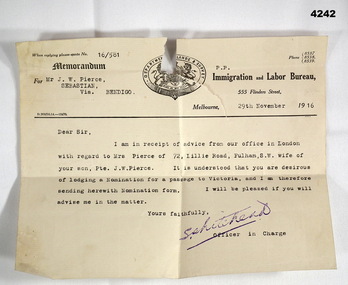
Letter - ADMINISTRATION LETTER, 29.11.1916
The letter from the immigration and Labour Bureau revolves around J.W.Pierce getting his sons wife passage to Australia. The son is also J.W.Pierce No 261 21st Batt AIF who was in France. His wife’s name was Hazel whom he married in late 1916. James returned home in 1919, there is no records in his service documents as to his wife getting passage to Australia. This is George Frederick Pierces brother. George won the DCM. Refer Cat No 4136P for his service details, award and death. Part of the collection of William (Bill) Thomason, refer Cat No 4136P for more items.Letter on official letterhead, yellowed colour, printed in black, ref No 16/581, entries typed in black. At th top is a coat of Arms with “Department of Lands and Survey" around the top.“For Mr J.W. Pierce Sebastion Via Bendigo, 29th November 1916”letters, immigration, military -
 Bendigo Historical Society Inc.
Map - CAMPBELL COLLECTION: BENDIGO AND DISTRICT MAPS, 1959
Map. Huntly, County of Bendigo, Neilborough, Bagshot, Nerring, Wellsford, Sandhurst. Township of Huntly. By Authority A.C. Brooks, Government Printer Melbourne. Drawn and reproduced at the Department of Lands and Survey, Melbourne, 1958. Price 5/-.A.C. Brooks, Government Printermap, bendigo, allotments, huntly -
 Bendigo Historical Society Inc.
Map - PLAN GENERAL SURVEY MALMSBURY PORCUPINE INN, FOREST CREEK TO GOLDEN POINT. ALEXANDRA RANGE 1853
Colour Copy of Plan of the General Survey from the Town of Malmsbury to the Porcupine Inn, from the sources of Forest Creek to Golden Point, shewing (sic) the Alexandrian Range also Sawpit Gully Bendigo and Bullock Creeks. Handwritten note under the title a follows '' Forwarded to the Colonial Secretary with my letter No A 53/105 dated 30th March 1853 for transmission to the Geological Surveyor. R Hoddle Surveyor General. ' Stamped by Department of Mines Victoria with record#123 in Top right Hand corner. Also contains a catalogue number 2053/M/2. Part of the Contents of a DVD entitled 'Mapping Great Change' - Archival Maps, produced to support an exhibition in the Post Office Gallery Bendigo. A description of the Map, its history and implications for both historical and future discussions is contained in an Essay 'Mapping Great Changes' : The landscape of central Victoria by Gerry Gill.R. Hoddlemap, bendigo, country lands -
 Bendigo Historical Society Inc.
Map - FRED COWIE COLLECTION: AERIAL MAPS OF HEATHCOTE/EPPALOCK, 28-9-1960
Map, Heathcote C2, Township of Heathcote, Melbourne Road through town branching off to Bendigo & Echuca. Aerial Survey of Victoria. Photo-map prepared by Department of Crown Lands and Survey from photographs taken in 1960. Copied photographically at the Central Plan Office.Fred Cowie,46 McIvor Rd,Bgo..Central Plan Officemap, heathcote, fred cowie -
 Bendigo Historical Society Inc.
Document - MARKS COLLECTION: PARISH PLAN OF WHITE HILLS
Sepia coloured map showing allotments in Parish of Sandhurst (White Hills) Written on LH side of map town and Suburban Lots White Hills Parish of Sandhurst. Scale is shown in chains. Surveyed by Horage Walker. Photo lithographed at the Department of Lands & Survey, Melbourne by J.Noone, Price 1/-. 6th. January 1865. Map shows Race Course Reserve at top of sheet, Municipal boundary is marked on LH side. Comments re vegetation throughout map. For example, poor soil timbered with Box scrub.on the back--Plan of Land White Hills Sandhurstbendigo, planning, white hills parish map, horage walker, j noone, department of lands and survey, -
Clunes Museum
Map, A.C. BROOKS GOVERNMENT PRINTER MELBOURNE, EGLINTON COUNTY OF TALBOT, 1965
MAP OF EGLINTONMAP OF EGLINTON, COUNTY OF TALBOT PRINTED ON CANVAS WITH PLASTIC TAB FOR HANGING. MAP SHOWS TOWN ALLOTMENTSADMINISTRATIVE STAMP ON BOTTOM LEFT AND ON THE BACK OF THE MAP ANOTHER STAMP - NORTHERN DIVISION (299) FORESTS COMMISSION BENDIGOeglinton, historical map