Showing 3237 items matching "lane"
-
 Eltham District Historical Society Inc
Photograph, Looking north across the Fitzsimons Lane Bridge over Yarra River between Eltham and Templestowe, c.1985, 1985c
Turnoff to Candlebark Park on right. The bridge over the Yarra River was initially opened September 22nd, 1961. Newspaper reports at the time of opening stated it linked Bolton Street, Eltham, with Fitzsimons Lane, Templestowe. In 1955 the Country Roads Board (CRB) produced survey plans that showed proposed land acquisition for the future bridge and road approaches. The 1955 plan shows that it was proposed to connect Fitzsimons Lane with Bolton Street in Eltham by a diagonal road across the river. The road connection would then continue along Bolton Street to Main Road. Prior to construction of the bridge the CRB modified the proposal significantly so that there was a new road parallel with Bolton Street and then curving to join Main Road at what was then its intersection with Old Eltham Road. This involved significantly more land acquisition and altered the pattern of land subdivision through this corridor. Initially the new road was just a single two-way carriageway as it would have required a significant widening of the cutting on the Shire of Eltham side of the river. The road was officially un-named but was known locally as the Eltham-Templestowe Road. The 1966 Melway street directory and other 1960s editions also listed the road as the Eltham-Templestowe Road. In December 1970, Eltham Shire Council, in pursuance of the provisions of the Local Government Act, named it Templestowe Road. The road was renamed Fitzsimons Lane around 1984 in conformity with the section south of the river. In 1991 a new bridge was built to the west of the original bridge. Fitzsimons Lane was widened to four traffic lanes although on the Eltham side this was done within the limits of the existing cutting. NEW BRIDGE STARTS THEM EXPLORING Without any fanfares, Country Roads Board workmen on Friday afternoon put the finishing touches to the approaches, removed the barricades, and let the traffic roll over the new Yarra bridge linking Bolton Street, Eltham, with Fitzsimons Lane, Templestowe. Over the week-end many “bridge watchers” who were making one of their periodic inspections of the progress on the new bridge found to their surprise that they could drive over it, so that people who had gone for a run out to Eltham suddenly found themselves wandering through Templestowe and Doncaster. By Monday the word of the bridge’s opening had got around sufficiently for many regular travellers to the city from Eltham and beyond to vary the monotony by going to town via Templestowe and Kew instead of through Heidelberg. They were surprised at the distances – about 3 ½ miles from Eltham to Templestowe, 6 miles from Eltham Shire hall to the Lower Heidelberg Road-Banksia Street intersection. NEW NEIGHBOURS For people on both sides of the river, the new bridge has turned distant friends into near neighbours. A Greensborough man on Sunday took 35 minutes to reach the home of a friend in East Doncaster, but the return trip over the new bridge took only 17 minutes. It will be some time yet before most people work out the possibilities in shorter and quicker trips form the north-eastern areas to the eastern and south-eastern suburbs. The coming of the warmer months will soon teach many, though the short cuts to Peninsular beaches and eastern suburban drive-ins. And before very long it is likely there will be a Tramways bus running from Templestowe to Eltham station. NEW BRIDGE STARTS THEM EXPLORING (1961, September 27). The Diamond Valley News (News clipping held in SEA_74-1_047) The previously un-named road between Main Road and Yarra River, Eltham South, east of Bolton Street was named Templestowe Road, December 15, 1970 NAMING OF STREETS AND ROADS. (1970, December 15). The Diamond Valley News (News clipping held in SEA_74-2_022)Colour photographinfrastructure, shire of eltham infrastructure, bridge, fitzsimons lane bridge, yarra river, candlebark park, red nose day -
 Eltham District Historical Society Inc
Photograph, Fitzsimons Lane Bridge over Yarra River between Eltham and Templestowe
The bridge over the Yarra River was initially opened September 22nd, 1961. Newspaper reports at the time of opening stated it linked Bolton Street, Eltham, with Fitzsimons Lane, Templestowe. In 1955 the Country Roads Board (CRB) produced survey plans that showed proposed land acquisition for the future bridge and road approaches. The 1955 plan shows that it was proposed to connect Fitzsimons Lane with Bolton Street in Eltham by a diagonal road across the river. The road connection would then continue along Bolton Street to Main Road. Prior to construction of the bridge the CRB modified the proposal significantly so that there was a new road parallel with Bolton Street and then curving to join Main Road at what was then its intersection with Old Eltham Road. This involved significantly more land acquisition and altered the pattern of land subdivision through this corridor. Initially the new road was just a single two-way carriageway as it would have required a significant widening of the cutting on the Shire of Eltham side of the river. The road was officially un-named but was known locally as the Eltham-Templestowe Road. The 1966 Melway street directory and other 1960s editions also listed the road as the Eltham-Templestowe Road. In December 1970, Eltham Shire Council, in pursuance of the provisions of the Local Government Act, named it Templestowe Road. The road was renamed Fitzsimons Lane around 1984 in conformity with the section south of the river. In 1991 a new bridge was built to the west of the original bridge. Fitzsimons Lane was widened to four traffic lanes although on the Eltham side this was done within the limits of the existing cutting. NEW BRIDGE STARTS THEM EXPLORING Without any fanfares, Country Roads Board workmen on Friday afternoon put the finishing touches to the approaches, removed the barricades, and let the traffic roll over the new Yarra bridge linking Bolton Street, Eltham, with Fitzsimons Lane, Templestowe. Over the week-end many “bridge watchers” who were making one of their periodic inspections of the progress on the new bridge found to their surprise that they could drive over it, so that people who had gone for a run out to Eltham suddenly found themselves wandering through Templestowe and Doncaster. By Monday the word of the bridge’s opening had got around sufficiently for many regular travellers to the city from Eltham and beyond to vary the monotony by going to town via Templestowe and Kew instead of through Heidelberg. They were surprised at the distances – about 3 ½ miles from Eltham to Templestowe, 6 miles from Eltham Shire hall to the Lower Heidelberg Road-Banksia Street intersection. NEW NEIGHBOURS For people on both sides of the river, the new bridge has turned distant friends into near neighbours. A Greensborough man on Sunday took 35 minutes to reach the home of a friend in East Doncaster, but the return trip over the new bridge took only 17 minutes. It will be some time yet before most people work out the possibilities in shorter and quicker trips form the north-eastern areas to the eastern and south-eastern suburbs. The coming of the warmer months will soon teach many, though the short cuts to Peninsular beaches and eastern suburban drive-ins. And before very long it is likely there will be a Tramways bus running from Templestowe to Eltham station. NEW BRIDGE STARTS THEM EXPLORING (1961, September 27). The Diamond Valley News (News clipping held in SEA_74-1_047) The previously un-named road between Main Road and Yarra River, Eltham South, east of Bolton Street was named Templestowe Road, December 15, 1970 NAMING OF STREETS AND ROADS. (1970, December 15). The Diamond Valley News (News clipping held in SEA_74-2_022)Black and white photographinfrastructure, shire of eltham infrastructure, bridge, fitzsimons lane bridge, yarra river -
 Eltham District Historical Society Inc
Photograph, Looking south across the Fitzsimons Lane Bridge over Yarra River between Eltham and Templestowe
The bridge over the Yarra River was initially opened September 22nd, 1961. Newspaper reports at the time of opening stated it linked Bolton Street, Eltham, with Fitzsimons Lane, Templestowe. In 1955 the Country Roads Board (CRB) produced survey plans that showed proposed land acquisition for the future bridge and road approaches. The 1955 plan shows that it was proposed to connect Fitzsimons Lane with Bolton Street in Eltham by a diagonal road across the river. The road connection would then continue along Bolton Street to Main Road. Prior to construction of the bridge the CRB modified the proposal significantly so that there was a new road parallel with Bolton Street and then curving to join Main Road at what was then its intersection with Old Eltham Road. This involved significantly more land acquisition and altered the pattern of land subdivision through this corridor. Initially the new road was just a single two-way carriageway as it would have required a significant widening of the cutting on the Shire of Eltham side of the river. The road was officially un-named but was known locally as the Eltham-Templestowe Road. The 1966 Melway street directory and other 1960s editions also listed the road as the Eltham-Templestowe Road. In December 1970, Eltham Shire Council, in pursuance of the provisions of the Local Government Act, named it Templestowe Road. The road was renamed Fitzsimons Lane around 1984 in conformity with the section south of the river. In 1991 a new bridge was built to the west of the original bridge. Fitzsimons Lane was widened to four traffic lanes although on the Eltham side this was done within the limits of the existing cutting. NEW BRIDGE STARTS THEM EXPLORING Without any fanfares, Country Roads Board workmen on Friday afternoon put the finishing touches to the approaches, removed the barricades, and let the traffic roll over the new Yarra bridge linking Bolton Street, Eltham, with Fitzsimons Lane, Templestowe. Over the week-end many “bridge watchers” who were making one of their periodic inspections of the progress on the new bridge found to their surprise that they could drive over it, so that people who had gone for a run out to Eltham suddenly found themselves wandering through Templestowe and Doncaster. By Monday the word of the bridge’s opening had got around sufficiently for many regular travellers to the city from Eltham and beyond to vary the monotony by going to town via Templestowe and Kew instead of through Heidelberg. They were surprised at the distances – about 3 ½ miles from Eltham to Templestowe, 6 miles from Eltham Shire hall to the Lower Heidelberg Road-Banksia Street intersection. NEW NEIGHBOURS For people on both sides of the river, the new bridge has turned distant friends into near neighbours. A Greensborough man on Sunday took 35 minutes to reach the home of a friend in East Doncaster, but the return trip over the new bridge took only 17 minutes. It will be some time yet before most people work out the possibilities in shorter and quicker trips form the north-eastern areas to the eastern and south-eastern suburbs. The coming of the warmer months will soon teach many, though the short cuts to Peninsular beaches and eastern suburban drive-ins. And before very long it is likely there will be a Tramways bus running from Templestowe to Eltham station. NEW BRIDGE STARTS THEM EXPLORING (1961, September 27). The Diamond Valley News (News clipping held in SEA_74-1_047) The previously un-named road between Main Road and Yarra River, Eltham South, east of Bolton Street was named Templestowe Road, December 15, 1970 NAMING OF STREETS AND ROADS. (1970, December 15). The Diamond Valley News (News clipping held in SEA_74-2_022)Black and white photographinfrastructure, shire of eltham infrastructure, bridge, fitzsimons lane bridge, yarra river -
 Eltham District Historical Society Inc
Photograph, Fitzsimons Lane Bridge over Yarra River between Eltham and Templestowe
The bridge over the Yarra River was initially opened September 22nd, 1961. Newspaper reports at the time of opening stated it linked Bolton Street, Eltham, with Fitzsimons Lane, Templestowe. In 1955 the Country Roads Board (CRB) produced survey plans that showed proposed land acquisition for the future bridge and road approaches. The 1955 plan shows that it was proposed to connect Fitzsimons Lane with Bolton Street in Eltham by a diagonal road across the river. The road connection would then continue along Bolton Street to Main Road. Prior to construction of the bridge the CRB modified the proposal significantly so that there was a new road parallel with Bolton Street and then curving to join Main Road at what was then its intersection with Old Eltham Road. This involved significantly more land acquisition and altered the pattern of land subdivision through this corridor. Initially the new road was just a single two-way carriageway as it would have required a significant widening of the cutting on the Shire of Eltham side of the river. The road was officially un-named but was known locally as the Eltham-Templestowe Road. The 1966 Melway street directory and other 1960s editions also listed the road as the Eltham-Templestowe Road. In December 1970, Eltham Shire Council, in pursuance of the provisions of the Local Government Act, named it Templestowe Road. The road was renamed Fitzsimons Lane around 1984 in conformity with the section south of the river. In 1991 a new bridge was built to the west of the original bridge. Fitzsimons Lane was widened to four traffic lanes although on the Eltham side this was done within the limits of the existing cutting. NEW BRIDGE STARTS THEM EXPLORING Without any fanfares, Country Roads Board workmen on Friday afternoon put the finishing touches to the approaches, removed the barricades, and let the traffic roll over the new Yarra bridge linking Bolton Street, Eltham, with Fitzsimons Lane, Templestowe. Over the week-end many “bridge watchers” who were making one of their periodic inspections of the progress on the new bridge found to their surprise that they could drive over it, so that people who had gone for a run out to Eltham suddenly found themselves wandering through Templestowe and Doncaster. By Monday the word of the bridge’s opening had got around sufficiently for many regular travellers to the city from Eltham and beyond to vary the monotony by going to town via Templestowe and Kew instead of through Heidelberg. They were surprised at the distances – about 3 ½ miles from Eltham to Templestowe, 6 miles from Eltham Shire hall to the Lower Heidelberg Road-Banksia Street intersection. NEW NEIGHBOURS For people on both sides of the river, the new bridge has turned distant friends into near neighbours. A Greensborough man on Sunday took 35 minutes to reach the home of a friend in East Doncaster, but the return trip over the new bridge took only 17 minutes. It will be some time yet before most people work out the possibilities in shorter and quicker trips form the north-eastern areas to the eastern and south-eastern suburbs. The coming of the warmer months will soon teach many, though the short cuts to Peninsular beaches and eastern suburban drive-ins. And before very long it is likely there will be a Tramways bus running from Templestowe to Eltham station. NEW BRIDGE STARTS THEM EXPLORING (1961, September 27). The Diamond Valley News (News clipping held in SEA_74-1_047) The previously un-named road between Main Road and Yarra River, Eltham South, east of Bolton Street was named Templestowe Road, December 15, 1970 NAMING OF STREETS AND ROADS. (1970, December 15). The Diamond Valley News (News clipping held in SEA_74-2_022)Black and white photographinfrastructure, shire of eltham infrastructure, bridge, fitzsimons lane bridge, yarra river -
 Eltham District Historical Society Inc
Photograph, Russell Yeoman, Fitzsimons Lane Bridge over Yarra River between Eltham and Templestowe, c.1970, 1970c
The bridge over the Yarra River was initially opened September 22nd, 1961. Newspaper reports at the time of opening stated it linked Bolton Street, Eltham, with Fitzsimons Lane, Templestowe. In 1955 the Country Roads Board (CRB) produced survey plans that showed proposed land acquisition for the future bridge and road approaches. The 1955 plan shows that it was proposed to connect Fitzsimons Lane with Bolton Street in Eltham by a diagonal road across the river. The road connection would then continue along Bolton Street to Main Road. Prior to construction of the bridge the CRB modified the proposal significantly so that there was a new road parallel with Bolton Street and then curving to join Main Road at what was then its intersection with Old Eltham Road. This involved significantly more land acquisition and altered the pattern of land subdivision through this corridor. Initially the new road was just a single two-way carriageway as it would have required a significant widening of the cutting on the Shire of Eltham side of the river. The road was officially un-named but was known locally as the Eltham-Templestowe Road. The 1966 Melway street directory and other 1960s editions also listed the road as the Eltham-Templestowe Road. In December 1970, Eltham Shire Council, in pursuance of the provisions of the Local Government Act, named it Templestowe Road. The road was renamed Fitzsimons Lane around 1984 in conformity with the section south of the river. In 1991 a new bridge was built to the west of the original bridge. Fitzsimons Lane was widened to four traffic lanes although on the Eltham side this was done within the limits of the existing cutting. NEW BRIDGE STARTS THEM EXPLORING Without any fanfares, Country Roads Board workmen on Friday afternoon put the finishing touches to the approaches, removed the barricades, and let the traffic roll over the new Yarra bridge linking Bolton Street, Eltham, with Fitzsimons Lane, Templestowe. Over the week-end many “bridge watchers” who were making one of their periodic inspections of the progress on the new bridge found to their surprise that they could drive over it, so that people who had gone for a run out to Eltham suddenly found themselves wandering through Templestowe and Doncaster. By Monday the word of the bridge’s opening had got around sufficiently for many regular travellers to the city from Eltham and beyond to vary the monotony by going to town via Templestowe and Kew instead of through Heidelberg. They were surprised at the distances – about 3 ½ miles from Eltham to Templestowe, 6 miles from Eltham Shire hall to the Lower Heidelberg Road-Banksia Street intersection. NEW NEIGHBOURS For people on both sides of the river, the new bridge has turned distant friends into near neighbours. A Greensborough man on Sunday took 35 minutes to reach the home of a friend in East Doncaster, but the return trip over the new bridge took only 17 minutes. It will be some time yet before most people work out the possibilities in shorter and quicker trips form the north-eastern areas to the eastern and south-eastern suburbs. The coming of the warmer months will soon teach many, though the short cuts to Peninsular beaches and eastern suburban drive-ins. And before very long it is likely there will be a Tramways bus running from Templestowe to Eltham station. NEW BRIDGE STARTS THEM EXPLORING (1961, September 27). The Diamond Valley News (News clipping held in SEA_74-1_047) The previously un-named road between Main Road and Yarra River, Eltham South, east of Bolton Street was named Templestowe Road, December 15, 1970 NAMING OF STREETS AND ROADS. (1970, December 15). The Diamond Valley News (News clipping held in SEA_74-2_022)Roll of 35mm black and white negative film, 4 of 7 stripsIlford HP4bridge, bridges, fitzsimons lane bridge, infrastructure, shire of eltham infrastructure, yarra river -
 Eltham District Historical Society Inc
Photograph, Fitzsimons Lane Bridge over Yarra River between Eltham and Templestowe, c.1966, 1966c
The bridge over the Yarra River was initially opened September 22nd, 1961. Newspaper reports at the time of opening stated it linked Bolton Street, Eltham, with Fitzsimons Lane, Templestowe. In 1955 the Country Roads Board (CRB) produced survey plans that showed proposed land acquisition for the future bridge and road approaches. The 1955 plan shows that it was proposed to connect Fitzsimons Lane with Bolton Street in Eltham by a diagonal road across the river. The road connection would then continue along Bolton Street to Main Road. Prior to construction of the bridge the CRB modified the proposal significantly so that there was a new road parallel with Bolton Street and then curving to join Main Road at what was then its intersection with Old Eltham Road. This involved significantly more land acquisition and altered the pattern of land subdivision through this corridor. Initially the new road was just a single two-way carriageway as it would have required a significant widening of the cutting on the Shire of Eltham side of the river. The road was officially un-named but was known locally as the Eltham-Templestowe Road. The 1966 Melway street directory and other 1960s editions also listed the road as the Eltham-Templestowe Road. In December 1970, Eltham Shire Council, in pursuance of the provisions of the Local Government Act, named it Templestowe Road. The road was renamed Fitzsimons Lane around 1984 in conformity with the section south of the river. In 1991 a new bridge was built to the west of the original bridge. Fitzsimons Lane was widened to four traffic lanes although on the Eltham side this was done within the limits of the existing cutting. NEW BRIDGE STARTS THEM EXPLORING Without any fanfares, Country Roads Board workmen on Friday afternoon put the finishing touches to the approaches, removed the barricades, and let the traffic roll over the new Yarra bridge linking Bolton Street, Eltham, with Fitzsimons Lane, Templestowe. Over the week-end many “bridge watchers” who were making one of their periodic inspections of the progress on the new bridge found to their surprise that they could drive over it, so that people who had gone for a run out to Eltham suddenly found themselves wandering through Templestowe and Doncaster. By Monday the word of the bridge’s opening had got around sufficiently for many regular travellers to the city from Eltham and beyond to vary the monotony by going to town via Templestowe and Kew instead of through Heidelberg. They were surprised at the distances – about 3 ½ miles from Eltham to Templestowe, 6 miles from Eltham Shire hall to the Lower Heidelberg Road-Banksia Street intersection. NEW NEIGHBOURS For people on both sides of the river, the new bridge has turned distant friends into near neighbours. A Greensborough man on Sunday took 35 minutes to reach the home of a friend in East Doncaster, but the return trip over the new bridge took only 17 minutes. It will be some time yet before most people work out the possibilities in shorter and quicker trips form the north-eastern areas to the eastern and south-eastern suburbs. The coming of the warmer months will soon teach many, though the short cuts to Peninsular beaches and eastern suburban drive-ins. And before very long it is likely there will be a Tramways bus running from Templestowe to Eltham station. NEW BRIDGE STARTS THEM EXPLORING (1961, September 27). The Diamond Valley News (News clipping held in SEA_74-1_047) The previously un-named road between Main Road and Yarra River, Eltham South, east of Bolton Street was named Templestowe Road, December 15, 1970 NAMING OF STREETS AND ROADS. (1970, December 15). The Diamond Valley News (News clipping held in SEA_74-2_022)Black and white photographManufacturer's marks: Polaroid, Batch #J62K181 (Sep 1966).infrastructure, shire of eltham infrastructure, bridge, fitzsimons lane bridge, polaroid, yarra river -
 Eltham District Historical Society Inc
Photograph, Fitzsimons Lane Bridge over Yarra River between Eltham and Templestowe
The bridge over the Yarra River was initially opened September 22nd, 1961. Newspaper reports at the time of opening stated it linked Bolton Street, Eltham, with Fitzsimons Lane, Templestowe. In 1955 the Country Roads Board (CRB) produced survey plans that showed proposed land acquisition for the future bridge and road approaches. The 1955 plan shows that it was proposed to connect Fitzsimons Lane with Bolton Street in Eltham by a diagonal road across the river. The road connection would then continue along Bolton Street to Main Road. Prior to construction of the bridge the CRB modified the proposal significantly so that there was a new road parallel with Bolton Street and then curving to join Main Road at what was then its intersection with Old Eltham Road. This involved significantly more land acquisition and altered the pattern of land subdivision through this corridor. Initially the new road was just a single two-way carriageway as it would have required a significant widening of the cutting on the Shire of Eltham side of the river. The road was officially un-named but was known locally as the Eltham-Templestowe Road. The 1966 Melway street directory and other 1960s editions also listed the road as the Eltham-Templestowe Road. In December 1970, Eltham Shire Council, in pursuance of the provisions of the Local Government Act, named it Templestowe Road. The road was renamed Fitzsimons Lane around 1984 in conformity with the section south of the river. In 1991 a new bridge was built to the west of the original bridge. Fitzsimons Lane was widened to four traffic lanes although on the Eltham side this was done within the limits of the existing cutting. NEW BRIDGE STARTS THEM EXPLORING Without any fanfares, Country Roads Board workmen on Friday afternoon put the finishing touches to the approaches, removed the barricades, and let the traffic roll over the new Yarra bridge linking Bolton Street, Eltham, with Fitzsimons Lane, Templestowe. Over the week-end many “bridge watchers” who were making one of their periodic inspections of the progress on the new bridge found to their surprise that they could drive over it, so that people who had gone for a run out to Eltham suddenly found themselves wandering through Templestowe and Doncaster. By Monday the word of the bridge’s opening had got around sufficiently for many regular travellers to the city from Eltham and beyond to vary the monotony by going to town via Templestowe and Kew instead of through Heidelberg. They were surprised at the distances – about 3 ½ miles from Eltham to Templestowe, 6 miles from Eltham Shire hall to the Lower Heidelberg Road-Banksia Street intersection. NEW NEIGHBOURS For people on both sides of the river, the new bridge has turned distant friends into near neighbours. A Greensborough man on Sunday took 35 minutes to reach the home of a friend in East Doncaster, but the return trip over the new bridge took only 17 minutes. It will be some time yet before most people work out the possibilities in shorter and quicker trips form the north-eastern areas to the eastern and south-eastern suburbs. The coming of the warmer months will soon teach many, though the short cuts to Peninsular beaches and eastern suburban drive-ins. And before very long it is likely there will be a Tramways bus running from Templestowe to Eltham station. NEW BRIDGE STARTS THEM EXPLORING (1961, September 27). The Diamond Valley News (News clipping held in SEA_74-1_047) The previously un-named road between Main Road and Yarra River, Eltham South, east of Bolton Street was named Templestowe Road, December 15, 1970 NAMING OF STREETS AND ROADS. (1970, December 15). The Diamond Valley News (News clipping held in SEA_74-2_022)Black and white photographinfrastructure, shire of eltham infrastructure, bridge, fitzsimons lane bridge, yarra river -
 Eltham District Historical Society Inc
Photograph, Fitzsimons Lane Bridge over Yarra River between Eltham and Templestowe
The bridge over the Yarra River was initially opened September 22nd, 1961. Newspaper reports at the time of opening stated it linked Bolton Street, Eltham, with Fitzsimons Lane, Templestowe. In 1955 the Country Roads Board (CRB) produced survey plans that showed proposed land acquisition for the future bridge and road approaches. The 1955 plan shows that it was proposed to connect Fitzsimons Lane with Bolton Street in Eltham by a diagonal road across the river. The road connection would then continue along Bolton Street to Main Road. Prior to construction of the bridge the CRB modified the proposal significantly so that there was a new road parallel with Bolton Street and then curving to join Main Road at what was then its intersection with Old Eltham Road. This involved significantly more land acquisition and altered the pattern of land subdivision through this corridor. Initially the new road was just a single two-way carriageway as it would have required a significant widening of the cutting on the Shire of Eltham side of the river. The road was officially un-named but was known locally as the Eltham-Templestowe Road. The 1966 Melway street directory and other 1960s editions also listed the road as the Eltham-Templestowe Road. In December 1970, Eltham Shire Council, in pursuance of the provisions of the Local Government Act, named it Templestowe Road. The road was renamed Fitzsimons Lane around 1984 in conformity with the section south of the river. In 1991 a new bridge was built to the west of the original bridge. Fitzsimons Lane was widened to four traffic lanes although on the Eltham side this was done within the limits of the existing cutting. NEW BRIDGE STARTS THEM EXPLORING Without any fanfares, Country Roads Board workmen on Friday afternoon put the finishing touches to the approaches, removed the barricades, and let the traffic roll over the new Yarra bridge linking Bolton Street, Eltham, with Fitzsimons Lane, Templestowe. Over the week-end many “bridge watchers” who were making one of their periodic inspections of the progress on the new bridge found to their surprise that they could drive over it, so that people who had gone for a run out to Eltham suddenly found themselves wandering through Templestowe and Doncaster. By Monday the word of the bridge’s opening had got around sufficiently for many regular travellers to the city from Eltham and beyond to vary the monotony by going to town via Templestowe and Kew instead of through Heidelberg. They were surprised at the distances – about 3 ½ miles from Eltham to Templestowe, 6 miles from Eltham Shire hall to the Lower Heidelberg Road-Banksia Street intersection. NEW NEIGHBOURS For people on both sides of the river, the new bridge has turned distant friends into near neighbours. A Greensborough man on Sunday took 35 minutes to reach the home of a friend in East Doncaster, but the return trip over the new bridge took only 17 minutes. It will be some time yet before most people work out the possibilities in shorter and quicker trips form the north-eastern areas to the eastern and south-eastern suburbs. The coming of the warmer months will soon teach many, though the short cuts to Peninsular beaches and eastern suburban drive-ins. And before very long it is likely there will be a Tramways bus running from Templestowe to Eltham station. NEW BRIDGE STARTS THEM EXPLORING (1961, September 27). The Diamond Valley News (News clipping held in SEA_74-1_047) The previously un-named road between Main Road and Yarra River, Eltham South, east of Bolton Street was named Templestowe Road, December 15, 1970 NAMING OF STREETS AND ROADS. (1970, December 15). The Diamond Valley News (News clipping held in SEA_74-2_022)Black and white photographinfrastructure, shire of eltham infrastructure, bridge, fitzsimons lane bridge, yarra river -
 Victorian Aboriginal Corporation for Languages
Book, Robert Lane Greene, You are what you speak : grammar grouches, language laws &? the power of words, 2011
Why does language move some of us to anxiety or even rage? For centuries, sticklers have donned the cloak of authority to control how people use words. In this sensational new book, Robert Lane Greene strikes back to defend the fascinating, real-life diversity of this most basic human faculty. Chapters: 1 Babel and the Damage Done 2 A Brief History of Sticklers 3 Another Way to Love Language 4 More Equal than Others 5 Welcome to X. Now Speak Xish 6 Insubordinate Clauses 7 The Microsoft and Apple of Languages 8 Clouds, Not Boxes.sociolinguistics, linguistics -
 Phillip Island and District Historical Society Inc.
Book, Walter George BELL, The great fire of London in 1666, 1920
Book belonged to Rudolf Himmer, programme controller for ABC Radio Victoria who had holiday home in Cowes on Phillip Island.Book belonged to Rudolf Himmer, Programme Controller for ABC Radio Victoria, who had a holiday home in Cowes on Phillip Island.387 p. : illus. 2d ed. Bibliography: p. 364-369. Stamped Cowes Library Labelled Himmer Bequestwalter george bell, the great fire of london in 1666, bodley head, john lane, rudolf himmer -
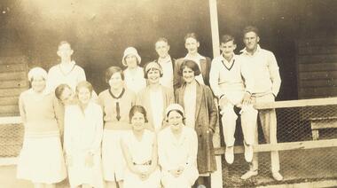 Ringwood and District Historical Society
Photograph, Ringwood Tennis Club (undated). Left Back Row - W. Dwight, Enid Connelly, Les Blood, Lance Lane, R. Skerritt, K. Storey. Standing - Vicki Cooper, Alex Kerford, Rose Storey, Nell Hargraves, Miss ? Bamford, Mrs. J. Jamieson. Sitting - Miss J. Payne and Miss Edith Blood
Written on back of photograph, "Ringwood Tennis Club". Attached note reads as follows: "Tennis Club. Left Back Row - W. Dwight, Enid Connelly, Les Blood, Lance Lane, R. Skerritt, K. Storey. Standing - Vicki Cooper, Alex Kerford, Rose Storey, Nell Hargraves, Miss ? Bamford, Mrs. J. Jamieson. Sitting - Miss J. Payne and Miss Edith Blood" -
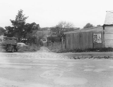 Ringwood and District Historical Society
Photograph, Edwin G. Adamson A.R.P.S, Maroondah Highway Central, Ringwood. Lane running from Adelaide St. to Warrandyte Rd.Ringwood 1963 (Eastland Litigation Photo)
This series of SS0380 photos are part of the "Eastland Litigation" launched in 1962 by the Whitehorse Traders Co-operative Association (WTCA), against the Ringwood Council's Interim Development Order of 1960. WTCA sought "orders from the Supreme Court of Victoria that the planning scheme was invalid" - See "The Eastland Litigation" chapter in "From Horse Shoes to High Heels - Ringwood Shopping Centre and Eastland 1858-2008" by Richard Carter, Bounce Books 2009.Black and White Photograph (2 copies)Written on back of photograph: "The lane running from Adelaide St. to Warrandyte Rd. Now Civic Place. Right-hand side where Jack Orr used to make clothes hoists. Left-hand side verging on plumber - S. Hunt then Horman & Woolhouse.' Stamp on photograph reads, 'Edwin G. Adamston A.R.P.S. Chartres House, Melbourne, Date May '63'. And on one copy stamped "IN THE SUPREME COURT E.W.L. 13 AUG 1963" -
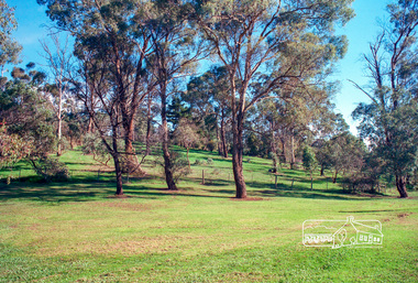
 Eltham District Historical Society Inc
Photograph, Looking west to reserve bounded by Main Road, Bolton Street and Fitzsimons Lane from Fitzsimons Lane roundabout, Eltham, c.May 2001
Roll of 35mm colour negative film, 7 stripsAgfa HDC 200 plus-2eltham, streets, main road, fitzsimons lane reserve, fitzsimons lane -
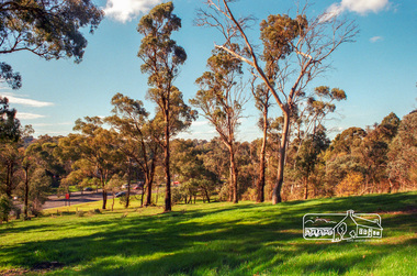
 Eltham District Historical Society Inc
Photograph, Fitzsimons Lane Reserve bounded by Main Road, Bolton Street and Fitzsimons Lane, Eltham, c.May 2001
Now partially developed as the Monarch Ridge housing estateRoll of 35mm colour negative film, 7 stripsAgfa HDC 200 plus-2eltham, streets, main road, fitzsimons lane reserve, houses, monarch ridge estate -
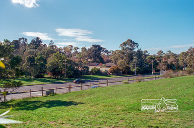
 Eltham District Historical Society Inc
Photograph, Fitzsimons Lane Reserve bounded by Main Road, Bolton Street and Fitzsimons Lane, Eltham, c.May 2001
Now partially developed as the Monarch Ridge housing estateRoll of 35mm colour negative film, 7 stripsAgfa HDC 200 plus-2eltham, streets, main road, fitzsimons lane reserve, monarch ridge estate -
Port Melbourne Historical & Preservation Society
Book, Lurking in Lanes, 1998
'Lurking in Lanes: a back fence history of the Lanes and Little Streets of Port Phillip', exhibition curated by the City of Port Phillip 1998'Lurking in Lanes: a back fence history of the Lanes and Little Streets of Port Phillip', a catalogue accompanying the exhibition curated by the City of Port Phillip 30pp, 1998engineering - roads streets lanes and footpaths, built environment - civic, domestic life, business and traders, built environment - domestic, glen cosham, janice c morton macdonald, glen stuart -
 Eltham District Historical Society Inc
Photograph - Digital Photograph, Alan King, Sweeney's Cottage, Sweeneys Lane, Eltham, 30 January 2008
Part of the original cottage named Culla Hill built by Thomas Sweeney (a former convict) remains as a small section of today’s house. Covered under Heritage Overlay, Nillumbik Planning Scheme National Estate National Trust of Australia (Victoria) Local Sifgnificance Published: Nillumbik Now and Then / Marguerite Marshall 2008; photographs Alan King with Marguerite Marshall.; p19 Thomas Sweeney, a former convict who became a respected citizen, once lived on a property at what is now the corner of Sweeneys Lane and Culla Hill, Eltham. As Sweeney was one of the district’s first settlers, the property is registered by the National Trust. Thomas Sweeney was born in 1802, son of impoverished tenant farmers in Tipperary County, Ireland. He became a ploughman, then at 21 he was sentenced to hang for setting on fire the house of Patrick Guyder at Gullshill. It is said the arson was due to a dispute over undelivered guns to a social justice guerilla group, the White Boys, of which Sweeney was a member. But the sentence was commuted to life transportation to Australia in 1823.1 Apparently in Sydney he became a servant to James Chandler at Botany. Soon James Chandler leased his farm and became a catechist on the Hawkesbury River, so Sweeney was reassigned to a former convict, John Brown, at Liverpool. Later Sweeney was assigned to George Brown of Lake Illawarra. In 1831, Sweeney was granted a ticket-of-leave and bought a boat to carry goods between Illawarra district and Sydney Town. He married his first wife who had come to Australia as a free woman. However she drowned after bearing him a daughter. In 1838, one month after he had received a conditional pardon, Sweeney married a blacksmith’s daughter, Margaret Meehan, newly arrived from Ireland. They then moved to Port Phillip and squatted on the south side of the Yarra River, about seven miles (11km) from Melbourne. Around 1842, Sweeney bought 110 acres (44.5ha) in the parish of Nillumbik for £110. He built a slab hut 12 x 10 feet (3.6m x 3m) and then his homestead, Culla Hill, a typical Tipperary style cottage, now known as Sweeney’s Cottage. It was here that many generations of Sweeneys lived for almost 100 years. Culla Hill became a social centre for the district and the Catholic community used it as a church. Sweeney was apparently on good terms with a tribe of Aborigines living on the river nearby, who helped him build his house.2 Sweeney proved himself a civic-minded leader. In 1844, he led a call for a bridge over the Plenty River. He was on the first school board and supplied the first grain for Eltham’s mill. Sweeney profited during the gold rush, not by gold digging, but by providing supplies for nearby fields and others as far away as Beechworth.3 Thomas Sweeney died in 1867 and was buried at the Eltham Cemetery, leaving two sons, five daughters, and 300 acres (121.4ha), as well as Culla Hill. Culla Hill – by then reduced to 75 acres (30ha) – was sold out of the family in 1939, then renamed Sweeneys. The present Sweeneys Lane, running diagonally through the original holding, was the track to the house. Part of the original cottage remains as a small section of today’s house. The dining-family room fronted by a veranda is original, and although there have been some changes, the cedar door and most of the small 12-paned wooden-framed windows are original. The walls are made of the original hand-made brick. After buying the property in 1952 Mr and Mrs Burston demolished a dilapidated slab hut, a three-roomed detached kitchen and cellar, as materials needed to restore them were very difficult to obtain so soon after the war.4 However the barn remains almost in its original condition. It is believed to have been built from stone quarried on the property. Now roofed with iron sheets it was probably originally thatched. The sandstone barn has a peaked roof supported by the original saplings and a doorway large enough to accommodate a fully loaded wagon.This collection of almost 130 photos about places and people within the Shire of Nillumbik, an urban and rural municipality in Melbourne's north, contributes to an understanding of the history of the Shire. Published in 2008 immediately prior to the Black Saturday bushfires of February 7, 2009, it documents sites that were impacted, and in some cases destroyed by the fires. It includes photographs taken especially for the publication, creating a unique time capsule representing the Shire in the early 21st century. It remains the most recent comprehenesive publication devoted to the Shire's history connecting local residents to the past. nillumbik now and then (marshall-king) collection, culla hill, eltham, sweeney's cottage, sweeneys lane, thomas sweeney -
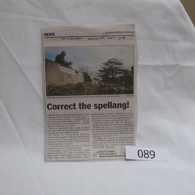 Greensborough Historical Society
Newspaper - Newspaper clipping, Correct the spellang!, 22/06/2011
McLaughlins Lane was named after Michael McLaughlin who settled in the area in 1840. An office error misspelt the name to McLaughlans Lane and family members have approached council to correct the mistake.Shirley Black was a foundation member of the Greensborough Historical Society and a long time resident of the area.Newspaper cutting from Diamond Valley Leader 22/6/2011, p16. Photograph of Shirley Black who was campaigning to have McLaughlans Lane Plenty returned to its original spelling of Mclaughlins LaneDate written in pen.shirley black, mclaughlin family, mclaughlans lane plenty, street names -
 Stawell Historical Society Inc
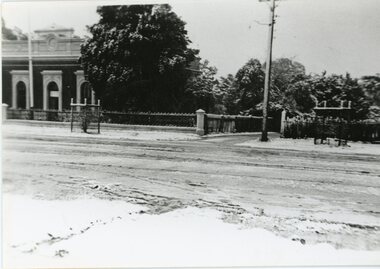
Photograph, Stawell Shire Hall built 1866, c 1949
Black & white photograph of Stawell Shire Hall, taken in July 1949 when Stawell had a heavy snow fall. The photo shows the Shire Hall to the left of trees, with a laneway beside. A telegraph pole stands on the right side of the lane. The lane called Millers Lane was named in 2012. The snow fall occurred on the 18th of July 1949.Black & white photograph of the Stawell Shire Hall and Millers Lane. The photograph was taken in 1949 when snow had fallen in Stawell. Millers Lane has a telegraph pole on the corner. Longfield road looks cleared of snow but thick on either side of the road. Two tree guards can be seen in the street verge either side of Millers Lane. stawell shire hall -
 Sunbury Family History and Heritage Society Inc.
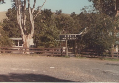
Photograph, Bulla Primary School, 1988
A coloured photograph of the main entrance to Bulla Primary School taken in school Lane. The photograph was included in the collection which went into the capsule which was put together in 1988. bulla, bulla primary school, schools, school capsules. -
 Warrnambool and District Historical Society Inc.
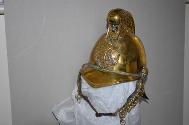
Helmet, Firmin & Sons, Fireman's helmet, Early 20th century
This fire helmet may have been one used in England or one used in the late 19th century and early 20th century in Australia. It was made by Firmin & Sons of England, a firm which was founded in 1655. It supplies military ceremonial buttons, badges and uniforms and brass and pith helmets of various kinds. It is regarded as the oldest manufacturing business operating in England today. The Warrnambool Fire Brigade was established in the early 1860s and today has both paid and volunteer firefighters.This helmet has no known local provenance but is retained for display purposes.This is a brass helmet with an oval crown with an ornate scrolled curved piece coming over the crown. There is a decoration of a winged dragon breathing fire and on the front side a torch, an axe and a hose with decorative surrounds. There is a breathing hole at the top of the crown in a petal shape. On the sides are metal medallions holding a chin strap which is adjustable. The edge of the crown has a scrolled band. The front peak is angled with a folded metal edge and the rear peak is a concave shape with a brass screw in the middle. Inside the helmet are 8 screws holding the upper decorative arching piece and a black leather band with eyelets tied together to fir the individual head. There is an oval plaque with wording contained within a decorative belt.Firmin & Sons Ltd 108 & 109 St Martins Lane W.C. Late of 153 & 154 Strandwarrnambool fire brigade, history of warrnambool -
Whitehorse Historical Society Inc.
Document, Mayoral dinner, 2012
Mayoral dinner invitation to Vicki Jones-Evans by Mark Lane, Mayor, City of Whitehorse.Mayoral dinner invitation to Vicki Jones-Evans by Mark Lane, Mayor, City of Whitehorse.Mayoral dinner invitation to Vicki Jones-Evans by Mark Lane, Mayor, City of Whitehorse.jones-evans, vicki, mayoral dinners, city of whitehorse, lane, mark -
Whitehorse Historical Society Inc.
Article, From paperboy to radio star, 2003
Article about former Mitcham resident Dave O'Neil, now comedian and breakfast radio host for Nova FM's breakfast team.Article about former Mitcham resident Dave O'Neil, now comedian and breakfast radio host for Nova FM's breakfast team. Other broadcasters who grew up in the area are Virginia Trioli from Nunawading, Terry Lane from Blackburn and Darren James from Box Hill North.Article about former Mitcham resident Dave O'Neil, now comedian and breakfast radio host for Nova FM's breakfast team.o'neil, dave, trioli, virginia, lane, terry, james, darren, mitcham, blackburn, box hill north, radio broadcasting -
 Orbost & District Historical Society
black and white photographs, C 1970s
3288.1 has been taken in Lawson Lane, Orbost, looking west from the rear of the Shire Offices. 3288.2 has been taken in Lawson Lane, Orbost, looking east from the rear of the Shire Offices.These photographs are pictorial records of the Orbost township C 1970s.Two black / white photographs showing cars parked on an unsealed road with buildings in the background.lawson-lane-orbost streets-orbost-1970s