Showing 335 items
matching map box
-
 Creswick Campus Historical Collection - University of Melbourne
Still Image, 1952
Subject: King Lake . 6 brown envelopes marked Run 3, 4, 7, 7a, 8, 9 containing c. 80 prints. 1 section of a topographical map marked State Aerial Survey. Stored in a brown cardboard file box marked King Lake Run No.3 - 9. (x9). Photos commissioned by Forests Commission Victoria.Aerial Photographs -
Creswick Campus Historical Collection - University of Melbourne
Still Image, 1968
Subject: Creswick 1968 Project . 1 x annotated map in envelope marked Run 3 No's 30 - 38 with runs marked up from aerial phtographs flown 1956 - 1968 on drafted plan of Creswick Plantations. 1 x topographical map marked Creswick with annotation "Mapsheet key diagram". 1 x topographical map marked Ballarat annotated with a grid of numbers. 13 brown envelopes marked Run 1 -3 No. 21 - 38 (missing sequences) of c.44 prints total. Mix of black and white and colour. Range of dates. Stored in a brown cardboard file box marked Creswick 1968 Project.Aerial Photographs -
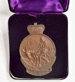 Chiltern Athenaeum Trust
ANZAC Commemorative Medallion (instituted in 1967) P. T. Bernard, 1967
Manufactured in 1967 to commemorate the WW1 ANZAC Gallipoli Peninsular Campaign in 1915. Issued to recipient P. T. Bernard. For commemoration of service throughout the Gallipoli Campaign in 1915. Issued to P. T. Bernard.Cast in Bronze. 75mm high and 50mm wide. Obverse depicts Simpson and his donkey carrying a wounded soldier to safety. It is bordered on the lower half by a laurel wreath above the word ANZAC. Reverse shows a map of Australia and New Zealand superimposed by the Southern Cross. The lower half is bordered by the New Zealand Fern leaves. The name and initials of the recipient is engraved and the medallion is issued in a presentation box. Engraved for P. T. Bernard. Engraved for recipient P.T. Bernard. ww1 anzac gallipoli campaign 1915, anzac commemorative medal, ww1 1914-1918, gallipoli and anzac, p. t. bernard soldier. -
Stawell Historical Society Inc
Archive - Maps, Victorian Government, Bailliere's Country Atlas of Victoria, 1866
... Large Boxed Volume of Maps in Book Burgandy Coloured Box... of the Mining and Survey Department Large Boxed Volume of Maps in Book ...Stawell is on Wimmera & Loddon MapLarge Boxed Volume of Maps in Book Burgandy Coloured BoxUnder the Supervision of the Mining and Survey Department -
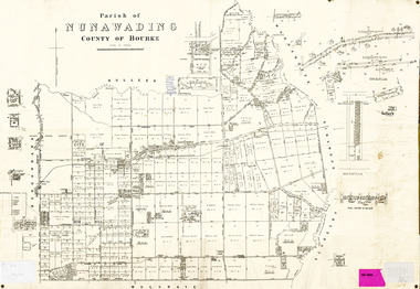 Whitehorse Historical Society Inc.
Legal record - Map, Parish of Nunawading, c1930
Office of Lands and survey map, 1864 with many further subdivisions of 1870 onwards added.Office of Lands and survey map, 1864 with many further subdivisions of 1870 onwards added. Boundaries of City of Box Hill included. Note added re Slater's land in Blackburn North. Office of Lands and survey map, 1864 with many further subdivisions of 1870 onwards added. maps, shire of blackburn and mitcham, city of box hill, slater family -
Whitehorse Historical Society Inc.
Map, Aerial photographs Nunawading, 1972
Department of Crown Lands and Survey, Melbourne, 1972.Department of Crown Lands and Survey, Melbourne, 1972. Project runs 34 - 39 - City of Nunawading. frames numbered from South to North boundaries, each strip numbered from West to east. The series extends further West to Box Hill and East to Ringwood than the 1970 project. No index map. Sheets 39/2 and 34/28 missing.non-fictionDepartment of Crown Lands and Survey, Melbourne, 1972.victoria. department of crown lands and survey, aerial photographs, nunawading, mitcham, blackburn, blackburn north, blackburn south, forest hill, vermont, burwood east, box hill, ringwood, vermont south -
Whitehorse Historical Society Inc.
Map, Aerial photographs Nunawading, 1976
Department of Crown Lands and Survey, Melbourne, 1976 Project.Department of Crown Lands and Survey, Melbourne, 1976 Project. Runs 29 - 33 City of Nunawading. Frames numbered from South to North boundaries, each strip numbered from West to East. No index map. Sheets 30/8 and 30/9 missing.non-fictionDepartment of Crown Lands and Survey, Melbourne, 1976 Project. victoria. department of crown lands and survey, aerial photographs, nunawading, mitcham, blackburn, blackburn north, blackburn south, forest hill, vermont, vermont south, burwood east, box hill, ringwood -
Whitehorse Historical Society Inc.
Map, Shire of Nunawading (part)
... along Whitehorse Road from Box hill to Mitcham. Photocopy of map ...Photocopy of map of part of Shire of Nunawading. area along Whitehorse Road from Box hill to Mitcham.Photocopy of map of part of Shire of Nunawading. area along Whitehorse Road from Box hill to Mitcham. Mitcham Station marked as Emery's Hill.Photocopy of map of part of Shire of Nunawading. area along Whitehorse Road from Box hill to Mitcham.maps, shire of nunawading, box hill, blackburn, nunawading, mitcham, emery's hill -
Whitehorse Historical Society Inc.
Map, Aspinall's old abattoirs, Box Hill, 1937
... abattoirs, Box Hill Map Map ...Hand drawn plan of subdivision of old abattoirs site, Woodhouse Grove, Box Hill North.Hand drawn plan of subdivision of old abattoirs site, Woodhouse Grove, Box Hill North.Hand drawn plan of subdivision of old abattoirs site, Woodhouse Grove, Box Hill North.land subdivision, aspinall's estate, woodhouse grove, box hill north, aspinall road, box hill north, abattoirs -
Whitehorse Historical Society Inc.
Map, Map 1892. Nunawading Shire, 1892
... to Box Hill Brick Co. Maps Shire of Nunawading Railways Box Hill ...Duplicated same as ND5060 Map of Shire of Nunawading.Duplicated same as ND5060 Map of Shire of Nunawading. Shows railway line including spur from Box Hill to Box Hill Brick Co.Duplicated same as ND5060 Map of Shire of Nunawading. maps, shire of nunawading, railways, box hill brick company -
Whitehorse Historical Society Inc.
Document, Gordon Hildesley Neve, 3/10/1975 12:00:00 AM
Letter, 3 Oct 1975 from Mr Neve and copy of 1858 agreement with Box Hill Council relating to connection of electricity to his home at 39 Wattle Valley Road Mitcham,Letter, 3 Oct 1975 from Mr Neve and copy of 1858 agreement with Box Hill Council relating to connection of electricity to his home at 39 Wattle Valley Road Mitcham, later (1975) 12 Nara Road. With map.Letter, 3 Oct 1975 from Mr Neve and copy of 1858 agreement with Box Hill Council relating to connection of electricity to his home at 39 Wattle Valley Road Mitcham,electricity supply, neve, gordon hildesley, city of box hill, mitcham, wattle valley road, nara road, cook street, burnett street, sharrow road -
Whitehorse Historical Society Inc.
Map, Whitehorse Road, Blackburn, 1970
Enlarged aerial photograph of area around intersection of Whitehorse and Middleborough Roads, BlackburnEnlarged aerial photograph of area around intersection of Whitehorse and Middleborough Roads, BlackburnEnlarged aerial photograph of area around intersection of Whitehorse and Middleborough Roads, Blackburnwhitehorse road, blackburn, middleborough road, blackburn, maroondah highway, box hill, aerial photographs -
Whitehorse Historical Society Inc.
Map, Canterbury Road, Blackburn, 1972
Enlarged aerial photograph of area around the intersection of Canterbury and Middleborough Roads, Blackburn.Enlarged aerial photograph of area around the intersection of Canterbury and Middleborough Roads, Blackburn.Enlarged aerial photograph of area around the intersection of Canterbury and Middleborough Roads, Blackburn.canterbury road, blackburn, middleborough road, blackburn, box hill, craig street, blackburn, hirst street, blackburn, aerial photographs -
Whitehorse Historical Society Inc.
Letter - Correspondence, Valuation of Abattoirs Paddock lots, 1932
Letter from Shire valuer to Cit of Box Hill re valuations of Abattoir Paddock lots, including map of lots.Letter from Shire valuer to Cit of Box Hill re valuations of Abattoir Paddock lots, including map of lots.Letter from Shire valuer to Cit of Box Hill re valuations of Abattoir Paddock lots, including map of lots.shire of blackburn and mitcham, city of box hill, abattoirs paddock, aspinall's estate, woodhouse grove, box hill north -
Whitehorse Historical Society Inc.
Map, Aerial maps, 2/04/1966 12:00:00 AM
Melbourne 1966 project, runs 10A and 11A, lens 122 151.75 mm 9,800. Photo nos 77, 107, 109, 161, 163, 165.Melbourne 1966 project, runs 10A and 11A, lens 122 151.75 mm 9,800. Photo nos 77, 107, 109, 161, 163, 165. Areas and boundaries: Map no 77 W. Park and Cook Roads; E. Dubon Rd; N Oban Rd; S Reilly St. Map No 107. W. Indra Rd and Pakenham St; E. Rooks Rd & McLares Rd; N. Maroondah Hwy; S. Hawthorn Rd & Eley Rd. Map No 109 W. Elgar Rd. E. Blackburn Rd & McKean St; S. Eley Rd & Burwood Hwy. Map No 161. W. Elgar Rd & Huntingdale Rd; E. Blackburn Rd; N. Burwood Hwy; S. Waverley Rd. Map No 163. W. Blackburn Rd; S. Springvale Rd; N. Eley Rd & Hawthorn Rd; S. Glen Waverley Railway Line. Map No 165. W. Stanley Rd, Vermont South; E. Cathies Lane, Wantirna South; N. North of Burwood Hwy; S. High Street. Melbourne 1966 project, runs 10A and 11A, lens 122 151.75 mm 9,800. Photo nos 77, 107, 109, 161, 163, 165. aerial photographs, blackburn, blackburn south, forest hill, nunawading, box hill, burwood, burwood east, donvale, mount waverley, glen waverley, wantirna, vermont south, mitcham, ringwood north, ringwood -
Whitehorse Historical Society Inc.
Map, Parish of Nunawading, 1927
... Parish of Nunawading Borough of Box Hill Map of the Parish ...Map of the Parish together with part of the Borough of Box Hill.Map of the Parish together with part of the Borough of Box Hill. Includes names of lease or license holders, sizes of leases and in some areas dates of leases. Roads, railway and stations marked. Original survey by W.J.Busocon, 1915. Manuscript note: 15.2.1927 Verified Dept. Lands and Survey.Map of the Parish together with part of the Borough of Box Hill. maps, parish of nunawading, borough of box hill -
Whitehorse Historical Society Inc.
Pamphlet, Information Bulletin, 1/12/1993
Freeway Extension between Doncaster Road and Springvale Road to go ahead.Freeway Extension between Doncaster Road and Springvale Road to go ahead. Map showing location and history of project given.Freeway Extension between Doncaster Road and Springvale Road to go ahead. freeways, doncaster road, doncaster, springvale road, nunawading, vicroads, city of nunawading, city of camberwell, city of box hill, city of ringwood -
Whitehorse Historical Society Inc.
Map, Burwood Road, Box Hill City, 1952
... Mitcham melbourne maps burwood road burwood parer street elgar ...Country Roads Board survey of Burwood Road, Burwood between Central Avenue and Elgar Road. Includes details of fencing, nature of buildings. With penciled additions to 1957.Country Roads Board survey of Burwood Road, Burwood between Central Avenue and Elgar Road. Includes details of fencing, nature of buildings. With penciled additions to 1957.Country Roads Board survey of Burwood Road, Burwood between Central Avenue and Elgar Road. Includes details of fencing, nature of buildings. With penciled additions to 1957.maps, burwood road, burwood, parer street, elgar road, cromwell street, ireland street, central avenue burwood, scott grove, somers street, gilmour street, evans street, edwards street, mills road -
Whitehorse Historical Society Inc.
Map, Burwood Road, Box Hill City, 15/02/1952 12:00:00 AM
... Road, Box Hill City Map Map ...Plan of subdivision of ten blocks in Burwood Road, Burwood.Plan of subdivision of ten blocks in Burwood Road, Burwood between Milford Avenue and Station Street. Marked as Survey Plan No 5441.Plan of subdivision of ten blocks in Burwood Road, Burwood. land subdivision, burwood road, burwood, milford avenue, burwood, central court, burwood -
Whitehorse Historical Society Inc.
Map, Burwood Road, Box Hill City, 15/02/1952 12:00:00 AM
... and Middleborough Road. Marked as Survey Plan No 5442. Burwood Road, Box ...Plan of subdivision of 19 blocks in Burwood Road, Burwood.Plan of subdivision of 19 blocks in Burwood Road, Burwood between Greenwood Street and Middleborough Road. Marked as Survey Plan No 5442.Plan of subdivision of 19 blocks in Burwood Road, Burwood. land subdivision, burwood road, burwood, greenwood street, burwood, middleborough road, burwood -
Whitehorse Historical Society Inc.
Map, Burwood Road, Box Hill City, 15/02/1952 12:00:00 AM
... . Marked as 'Survey Plan No 5440'. Burwood Road, Box Hill City Map ...Detailed map of subdivision along the north side of Burwood Road, Box Hill between Station Street and Middleborough Road.Detailed map of subdivision along the north side of Burwood Road, Box Hill between Station Street and Middleborough Road. Shows many block owners, types of buildings, nature of fencing. Marked as 'Survey Plan No 5440'.Detailed map of subdivision along the north side of Burwood Road, Box Hill between Station Street and Middleborough Road. maps, burwood road, burwood, andrews street, greenwood street, tennyson street, middleborough road, station street -
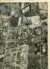 Whitehorse Historical Society Inc.
Map, Photo-map Ringwood A4A, 1945
Aerial photo covering approximately from Box Hill to Mitcham (West to East) and Springfield Road to Hawthorn Road (North to south).Aerial photo covering approximately from Box Hill to Mitcham (West to East) and Springfield Road to Hawthorn Road (North to south). Names of main roads inscribed.Aerial photo covering approximately from Box Hill to Mitcham (West to East) and Springfield Road to Hawthorn Road (North to south).aerial photographs, box hill, blackburn, nunawading, forest hill, mitcham -
Whitehorse Historical Society Inc.
Map, Eastern Suburbs, 1922
... Mitcham melbourne maps nunawading tunstall box hill blackburn ...Enlargement of sections of 1922 Ringwood Commonwealth Survey - Imperial General Staff (West - Camberwell; North - Templestowe; East - Ringwood; South - Clayton)maps, nunawading, tunstall, box hill, blackburn, mitcham, vermont, burwood east, mont albert -
Whitehorse Historical Society Inc.
Map, Nunawading, 1965
Map of Nunawading and surrounds: Eltham, Templestowe, Doncaster, Box Hill, Warrandyte, Park Orchards, Ringwood, Croydon, Lilydale and Mooroolbark .Map of Nunawading and surrounds: Eltham, Templestowe, Doncaster, Box Hill, Warrandyte, Park Orchards, Ringwood, Croydon, Lilydale and Mooroolbark . UBD map issued by Gazette Newspapers. Scale: 1:50,000Map of Nunawading and surrounds: Eltham, Templestowe, Doncaster, Box Hill, Warrandyte, Park Orchards, Ringwood, Croydon, Lilydale and Mooroolbark . blackburn, nunawading, vermont, forest hill, burwood east -
Whitehorse Historical Society Inc.
Map, Map of East and South eastern suburbs of Melbourne, 1930s
... Mitcham melbourne Blackburn Mitcham Hawthorn Box Hill Doncaster ...Map of suburbs of Melbourne from Kew to Ringwood and South Morang Station to East Oakleigh.Map of suburbs of Melbourne from Kew to Ringwood and South Morang Station to East Oakleigh.Map of suburbs of Melbourne from Kew to Ringwood and South Morang Station to East Oakleigh.blackburn, mitcham, hawthorn, box hill, doncaster, templestowe -
Whitehorse Historical Society Inc.
Map, VR Box Hill - Blackburn, 1953
... boundaries for Laburnum Station. VR Box Hill - Blackburn Map Map ...Maps of proposed station at Laburnum on Box Hill to Blackburn railway lines, by Victorian Railways, showing boundaries of Victorian Railways land and the proposed boundaries for Laburnum Station.Maps of proposed station at Laburnum on Box Hill to Blackburn railway lines, by Victorian Railways, showing boundaries of Victorian Railways land and the proposed boundaries for Laburnum Station.Maps of proposed station at Laburnum on Box Hill to Blackburn railway lines, by Victorian Railways, showing boundaries of Victorian Railways land and the proposed boundaries for Laburnum Station.laburnum railway station, laburnum street, blackburn, victorian railways -
Whitehorse Historical Society Inc.
Map, Surrey Hills to Croydon map, c1980
Surrey Hills to Croydon map, Drake & Co Pty Ltd.Surrey Hills to Croydon map, Drake & Co Pty Ltd.Surrey Hills to Croydon map, Drake & Co Pty Ltd.surrey hills, box hill, blackburn, forest hill, vermont, ringwood, mitcham, nunawading, maps -
Whitehorse Historical Society Inc.
Map, Sketch plan of Box Hill Cemetery, c1980
... Cemetery Sketch plan of Box Hill Cemetery Map Map ...Sketch plan of Box Hill Cemeterybox hill cemetery -
 Whitehorse Historical Society Inc.
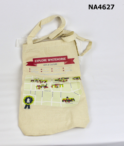
Memorabilia - Bag - Carrybag, 2013
Given away at 2013 City of Whitehorse Spring Festival, Whitehorse Civic Centre, Nunawading.Ecru calico carrybag printed on one side with 'Explore Whitehorse - Arts & Culture' in red headline. Underneath is a green map with numbers marking 1. Box Hill Community Arts Centre; 2. Whitehorse Art Space at Box Hill Town Hall; 3. Box Hill Library; 4. Blackburn Library; 5. Nunawading Library 6. Whitehorse Centre; 7. Vermont Library 8. Schwerkolt Cottage and Museum Complex; Contact details for Whitehorse City Council & Logo.City of Whitehorse; Explore Whitehorse-Arts & Culturecivic mementoes, souvenirs -
 Whitehorse Historical Society Inc.
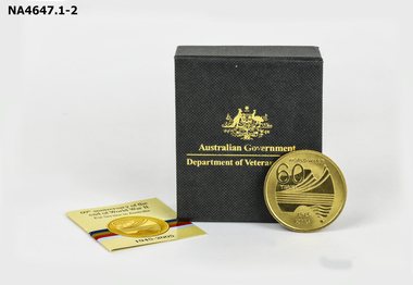
Memorabilia - Medallion, 2005
Medallion was minted to commemorate the 60th anniversary of the end of World War IIRound gold coloured medallion commemorating the 60th anniversary of the end of World War II. The front has a stylised map of Australia with 'World War II 60 years 1945-2005'. The back has the Australian Coat of Arms with 'World War II Service of Australia. The Medallion is contained in a black box with '60th anniversary of the end of World War II'. 'For Service to Australia'. A small brochure from The Royal Australian Mint.as above. On Box Australian Government - Department of Veterans' Affairs.military history, army