Showing 2635 items
matching map of victoria
-
 Bendigo Historical Society Inc.
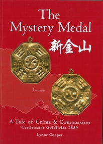
Book - The Mystery Medal. A Tale of Crime and Compassion. Castlemaine Goldfields 1889, Lynne Cooper, 2024
... of two sides of a gold coloured medal. map of Victoria outline... of a gold coloured medal. map of Victoria outline in background ...Biography of Henry William Frood who served 32 years as a member of the Victorian Police Force. Written by his great granddaughter Lynne Cooper. Soft cover book. Red soft cover with images of two sides of a gold coloured medal. map of Victoria outline in background. Illustrated with black and white and coloured photographs. 98 pp. Hand written on the Dedication page in gold coloured texta "Lynne Cooper Bendigo 2024 Available from: Goldfields Library & The Golden dragon Museum".henry william frood, chinese, medals -
 Orbost & District Historical Society
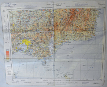
map, 1985
... A laminated map of eastern Victoria. A World Aeronautical... map of eastern Victoria. A World Aeronautical Chart. It shows ...An aeronautical chart is a map designed to assist in navigation of aircraft. Using these charts and other tools, pilots are able to determine their position, safe altitude, best route to a destination, navigation aids along the way, alternative landing areas in case of an in-flight emergency, and other useful information such as radio frequencies and airspace boundaries. World aeronautical charts have a scale of 1:1,000,000 and cover relatively large areas. Orbost Aero Club began in 1969 with Basil Dowie as Chair, David Nixon as Secretary/Treasurer. The group went into recess from 1977-1991 closing in 1997. The mid 1960s were boom years in flying training in Australia and the number of Aero Clubs grew rapidly. The Club played a significant role in the establishment of the small airport at Marlo and in the ongoing operation and development of the airport over the years particularly for patient transfer by aerial ambulance. The Orbost Aero Club Club played a significant role in the establishment of the small airport at Marlo and in the ongoing operation and development of the airport over the years.A laminated map of eastern Victoria. A World Aeronautical Chart. It shows elevations, longitude etc and is designed for pre-flight planning as well as pilotage. Top left hand corner - D.F.N.Nixon VH-FWD 12 Kristine Ct Cheletenham 27/7/87orbost-aero-club aeronautical-map -
 Glenelg Shire Council Cultural Collection
Domestic object - Coaster, n.d
... ' printed in blue and green ink in the centre of a black outline map... in the centre of a black outline map of Victoria. Portland Development ...Circular cardboard coaster, with 'Prosper in Portland' printed in blue and green ink in the centre of a black outline map of Victoria. Portland Development Committee, 63 Julia Street, Portland. Victoria 3305 ph (055) 232757' printed in a circle around the edge, between two black lines, 1 cm apart. Coaster size 9.3 cm Diameter -
 Bendigo Historical Society Inc.
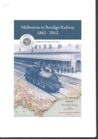
Book - RAILWAYS COLLECTION: MELBOURNE TO BENDIGO RAILWAY 1862-2012
... of a Railway map of Victoria,1947.... of a Railway map of Victoria,1947. Book RAILWAYS COLLECTION: MELBOURNE ...RAILWAYS COLLECTION -Booklet - Melbourne to Bendigo Railway 1862-2012. Produced by the Bendigo Historical Society Inc. in 2012 Editor Jim Evans. Paper booklet 21x30 cm stapled. The front cover shows a photo of steam Train (appears to be an A Class Loco) at Bendigo Railway Station C 1860's and part of a Railway map of Victoria,1947.Jim Evansbook -
 Whitehorse Historical Society Inc.
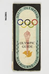
Memorabilia - Programme - Olympic, 1956
... of Melbourne and suburbs. Map of N.S.W. and Victoria.... of Melbourne and suburbs. Map of N.S.W. and Victoria. Memorabilia ...Program and guide map of city of Melbourne. Map of Melbourne and suburbs. Map of N.S.W. and Victoria.XVIth Olympiad Olympic Guide, Melbourne 1956.documents, programmes -
 Marysville & District Historical Society
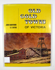
Book, Old Gold Towns of Victoria, 1970
... is a drawn map of Victoria showing all the towns mentioned... map of Victoria showing all the towns mentioned in the book ...Histories of the old gold towns in VictoriaHardback. Yellow dust cover. Front of jacket illustration-The Diggings, Ballarat. The poppet head, battery house, and mullock heap are typical of an old gold mine, and have been restored on Sovereign Hill over the old North Normandy mine. Back of jacket-The Bend in the Road, at Clunes. Inside both front and back cover is a drawn map of Victoria showing all the towns mentioned in the book. Stamp of the Marysville & District Historical Society Inc / P.O. Box 22 / Marysville 3779 Signature of H M Olivergold town, victoria, australia, history -
 Ringwood and District Historical Society
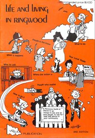
Booklet, Life and Living in Ringwood (1979)
... includes Municipality map of Ringwood, Victoria, Australia.... Municipality map of Ringwood, Victoria, Australia. Life and Living ...Orange covered Ringwood Community Guide - 1979, containing details of local Community Services and Business Listings. Also includes Municipality map of Ringwood, Victoria, Australia.A Resource Guide of - Places to go - Things to see and do - And people to see for helpand advice in your community. -
 Ringwood and District Historical Society
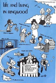
Booklet, Life and Living in Ringwood (1977)
... includes Municipality map of Ringwood, Victoria, Australia.... map of Ringwood, Victoria, Australia. Life and Living ...Blue covered Ringwood Community Guide - 1977, containing details of local Community Services and Business Listings. Also includes Municipality map of Ringwood, Victoria, Australia.A Resource Guide of - Places to go - Things to see and do - And people to see for helpand advice in your community. -
 Lakes Entrance Historical Society
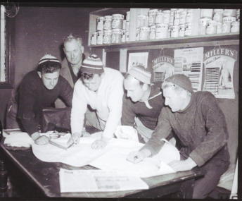
Photograph - Lakes Entrance Fishermen, Bulmer, 1960 c
... studying maps Lakes Entrance Victoria..., Vernon Newman studying maps Lakes Entrance Victoria Photograph ...Black and white photograph of fishermen Rex Greer, Chum, Chris Newman, Frank Newman, Ronnie Newman, Vernon Newman studying maps Lakes Entrance Victoriapeople, fishermen -
Whitehorse Historical Society Inc.
Map, Directory Maps of the County of Bourke, 1892
... also a complete map of the Colony of Victoria, showing all... the Parishes ... also a complete map of the Colony of Victoria, showing... Mitcham melbourne also a complete map of the Colony of Victoria ...Directory maps of the County of Bourke, containing all the Parishes ...Directory maps of the County of Bourke, containing all the Parishes ... also a complete map of the Colony of Victoria, showing all the Counties, Parishes, Railways and stations to date, and the Mallee Blocks. Lithographed by G.S.B. Bonney for the Victorian Shire Map Company. Scale: 40 chains to the inch.Directory maps of the County of Bourke, containing all the Parishes ...maps, victoria. county of bourke, t.r.b. morton & son -
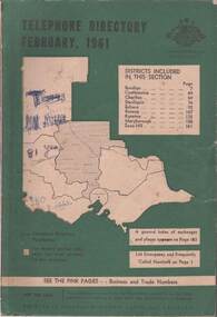 Bendigo Historical Society Inc.
Book - TELEPHONE DIRECTORY FEBRUARY 1961, February 1961
... background with an outline of the map of Victoria in white... Hill. Cover has a green background with an outline of the map ...Soft covered Telephone Directory February 1961. Districts covered are Bendigo, Castlemaine, Charlton, Deniliquin, Echuca, Kerang, Kyneton, Maryborough, Swan Hill. Cover has a green background with an outline of the map of Victoria in white. The Victorian Telephone directory boundaries are indicated and the district covered is shaded with black dots. Some handwritten jottings are written in ink on the cover. The directory contains both white and pink pages.book, bendigo, bendigo history & its people -
 Bendigo Historical Society Inc.
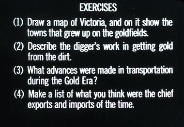
Slide - DIGGERS & MINING: THE GOLD ERA, c1850s
... Diggers & mining. The gold era. Exercises (1) Draw a map... era. Exercises (1) Draw a map of Victoria, and on it show ...Diggers & mining. The gold era. Exercises (1) Draw a map of Victoria, and on it show the towns that grew up on the goldfields. (2) Describe the digger's work in getting gold from the dirt. (3) What advances were made in transportation during the Gold Era? (4) Make a list of what you think were the chief exports and imports of the time. Markings 57 994.031 GOL:5. Used as a teaching aid.hanimounteducation, tertiary, goldfields -
 Whitehorse Historical Society Inc.
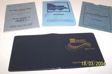
Book - State Savings Bank Books
... cloth cover with map of Victoria embossed in dark blue. 139... with map of Victoria embossed in dark blue. 139--153 Elizabeth ...Donor is a member of the Whitehorse Historical SocietyTwo State Savings Bank of Victoria bank books with blue cloth cover with map of Victoria embossed in dark blue. 139--153 Elizabeth Street branch 1956 (829444) 1960/68 (16616) Mitcham Branch. Plus state Savings Bank of Victoria Passbook cover, pale blue cardboard. Plus Travelers Cheques cover 1891-1999 State Bank Victoria. Very dark blue vinyl .The State Savings Bank of Victoriacommerce, banking -
University of Melbourne, Burnley Campus Archives
geological survey - Map, Maps of Geelong and Portarlington areas, 1963
... geological survey map of Portarlington, Victoria. By Dept. Of Mines... survey map of Portarlington, Victoria. By Dept. Of Mines ...A. Coloured geological survey map of Geelong area: showing sedimentary and igneous rock formations and contours. B. Coloured geological survey map of Portarlington, Victoria. By Dept. Of Mines, Melbourne.geological survey, geelong, portarlington -
 Bendigo Historical Society Inc.
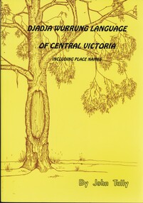
Book - DJADJA WURRUNG LANGUAGE OF CENTRAL VICTORIA INCLUDING PLACE NAMES, 1997
... Dadja wurrung language of central victoria 92 pages... victoria 92 pages with photos, illustrations and maps. Published ...Dadja wurrung language of central victoria 92 pages with photos, illustrations and maps. Published in Maryborough Victoria.John Tullyaboriginal, language, djadja wurrung, djadja wurrung, aboriginal language, bendigo aborigine -
 Frankston RSL Sub Branch
Map Case
... Survey map of Puckapunyal, Victoria produced in 1988... Survey map of Puckapunyal, Victoria produced in 1988. Inscription ...Standard Australian Army webbing map case with shoulder strap. This map case is complete with a folded Australian Survey map of Puckapunyal, Victoria produced in 1988. Inscription BHG Ltd 1945 -
 Federation University Historical Collection
Photograph - coloured, Department of Lands and Survey, Portion of Victoria showing auriferous areas and mineral localities, 1935, 1935
... Map included with book "Victoria: Gold and Minerals" issued... Fold out coloured map Portion of Victoria showing auriferous ...Map included with book "Victoria: Gold and Minerals" issued by Mines Department Victoria, 1935Fold out coloured mapYellow mark indicating depositsvictoria, auriferous areas, mineral localities, department of mines, tin, antimony, copper, silver lead, tungsten, manganese, platinum, iron -
 Eltham District Historical Society Inc
Document - Folder, Survey Maps and Technical Drawings
... of Victoria, published 1869, Issued 1914 4. Map: Lake Mountain.... Military Survey Map: Ballan, Victoria, No. 837 Zone 7, Sheet South ...alan gardiner collection, maps -
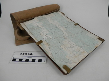
 Bendigo Historical Society Inc.
Map - CAMPBELL COLLECTION: BENDIGO AND DISTRICT MAPS
... Map. Forest Commission Victoria, Bendigo Forest District...MAP Bendigo forest district Map. Forest Commission Victoria ...Map. Forest Commission Victoria, Bendigo Forest District, Basic information prepared 1982, scale 1:100,000. Fire Prevention Strategy Plan. Mitiamo, Greater Bendigo Area, Castlemaine F.D.map, bendigo, forest district -
Glenelg Shire Council Cultural Collection
Map - Fold-out fire control map - Region 4 Victoria, n.d
... Fold-out fire control map - Region 4 Victoria...Fold-out fire control map for Region 4 - Victoria Northern... and alphabetical index. Map Fold-out fire control map - Region 4 Victoria ...Fold-out fire control map for Region 4 - Victoria Northern sheet, includes numerical and alphabetical index. -
University of Melbourne, Burnley Campus Archives
Map (item), Proposed Reserve for Horticultural & Experimental Garden in the Survey Paddock. Clement Hodgkinson Deputy Surveyor General, 1862
... Coloured printout of map in Public Record Office Victoria... Survey Paddock Clement Hodgkinson Coloured printout of map ...horticultural & experimental garden, survey paddock, clement hodgkinson -
Glenelg Shire Council Cultural Collection
Headwear - Town Crier's Hat - Syd Cuffe, n.d
... - gold map of Victoria Australia, Victorian flag, silver buffalo... - gold map of Victoria Australia, Victorian flag, silver buffalo ...Syd Cuffe's Town Crier's hat. Black felt sides, turned up with point in brim at front, back of brim also turned, trimmed in gold fabric black ribbon rosette on front brim, also 4 badges - gold map of Victoria Australia, Victorian flag, silver buffalo (Manitoba) and Canadian flag. Cockatoo feather threaded through gold ribbon on back. two small fabric appliqués on back turned up brim - red maple leafFront: Maker's tag inner crown. Red flower with green stemsyd cuffe, town crier, hat, headwear -
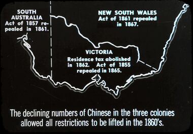 Bendigo Historical Society Inc.
Slide - DIGGERS & MINING. THE CHINESE ON THE GOLD FIELDS, c1850s
... : Shows map of Victoria and part of South Australia and New South.... The Chinese on the Gold Fields. Slide: Shows map of Victoria and part ...Diggers & Mining. The Chinese on the Gold Fields. Slide: Shows map of Victoria and part of South Australia and New South Wales. South Australia Act. Of 1857 repealed I 1861. New South Wales Act. Of 1861 repealed I 1867. Victoria Residence tax abolished in 1862. Act. Of 1855 repealed in 1865. The declining numbers of Chinese in the three colonies allowed all restrictions to be lifted in the 1860's. Markings: 2 2. Used as a teaching aid.hanimounteducation, tertiary, goldfields -
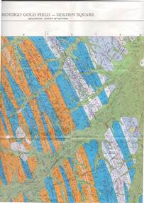 Bendigo Historical Society Inc.
Map - STRUGNELL COLLECTION: GEOLOGICAL SURVEY OF VICTORIA, BENDIGO GOLD FIELD - GOLDEN SQUARE, 1992
... Map, Geological Survey of Victoria, Bendigo Gold Field... Development. Map, Geological Survey of Victoria, Bendigo Gold Field ...Map, Geological Survey of Victoria, Bendigo Gold Field - Golden Square, Campaspe 10 000/2.2. Victoria 10,000.Dept. 0f Manufacturinf & Industry Development.map, bendigo, golden square gold field -
 Bendigo Historical Society Inc.
Map - STRUGNELL COLLECTION: GEOLOGICAL SURVEY OF VICTORIA, BENDIGO GOLD FIELD - EAGLEHAWK, 1992
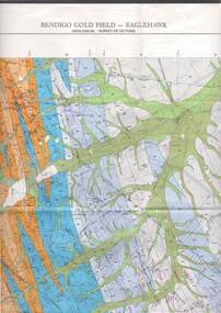
... Map, Geological Survey of Victoria, Bendigo Gold Field... Development Map, Geological Survey of Victoria, Bendigo Gold Field ...Map, Geological Survey of Victoria, Bendigo Gold Field - Eaglehawk.Campaspe10 000/2.3; Victoria 1:10,000. Index of Shafts.Dept. of Manufacturing & Industry Developmentmap, bendigo, eaglehawk gold field -
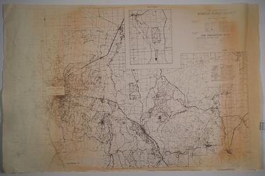
 Bendigo Historical Society Inc.
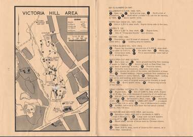
Document - VICTORIA HILL - VICTORIA HILL AREA MAP
... VICTORIA HILL - VICTORIA HILL AREA MAP... Victoria Hill Map...Photocopied map on cream paper. Map is the Victoria Hill...MAP Bendigo Victoria Hill Victoria Hill Map Gold Mines ...Photocopied map on cream paper. Map is the Victoria Hill area showing the locations of the Gold Mines Hotel, John Brown Factory and W Rae's Home. Map also shows mine shafts and open cuts.map, bendigo, victoria hill, victoria hill map, gold mines hotel, john brown factory, w rae's home, victoria consols, adventure and advance open cut, great central victoria, rae's open cut, victoria qiartz, ballerstedt's open cut, lansell's '180', north old chum, central nell gwynne -
Federation University Historical Collection
Book, George Brown, Prospectors' Guide (Victoria), 1936, 1936
... Brown soft covered book with pullout map showing auriferous... with pullout map showing auriferous areas of Victoria. Prospectors ...Brown soft covered book with pullout map showing auriferous areas of Victoria. prospecting, gold, geology, quartz reefs, indicators, ballarat indicators, miners' rights, mining leases, forest regulations, equipment, gold cradle, puddling machine, sluice box, whim, whip, california pump, cradle, mining, tools, mining laws -
 Bendigo Historical Society Inc.
Map - VICTORIA HILL AREA
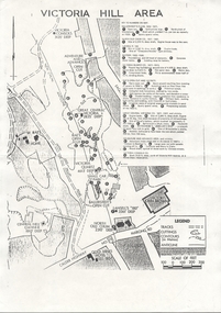
... Map of Victoria Hill Area printed on yellow paper. Details... Claim Victoria Hill Reserve Mines Dept Reervation Map ...Map of Victoria Hill Area printed on yellow paper. Details of tracks, cuttings, contours (in Metres) and Anticline. Location of mines, open cuts and buildings are shown. Numbers on map are: Ballerstedt's Claim 1 - 5; North Old Chum Co. 6; Lansell's 180, 7,8,11; Battery 9.10.12; Victoria Quartz Co. 13 - 17; Rae's Open Cut and Vicinity 18 - 28, Great Central Victoria Co 29 - 36, Adventure and Advance Area and vicinity 37 - 40 and Victoria Consols Co 41.map, bendigo, victoria hill, victoria hill area, victoria consols, new chum anticline, great central victoria, rae's open cut, w rae's home, victoria quartz, ballerstedt's open cut, lansell's 180, north old chum, central nell gwynne, john brown factory, gold mines hotel, cleopatra needle type chimney, floyd's battery, ballerstedt's 24yd claim, humboldt shaft, wittscheibe's jeweller's shop, luffsman and sterry's claim, victoria hill reserve, mines dept reervation -
 Warrnambool and District Historical Society Inc.
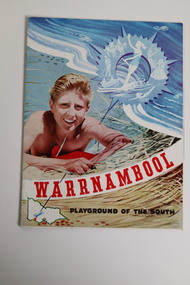
Document - Warrnambool Playground of the South Tourist Guide, Collett & Bain, 1959
... on the sand dunes, a small map of Victoria locating Warrnambool... an illustration of a young man on the sand dunes, a small map of Victoria ...A 1959 tourist guide showcasing Warrnambool attractions.This guide gives an insight into tourist attractions and facilities in Warrnambool in the late 1950'sThis 24page paper booklet contains colour and black and white photographs and text showcasing Warrnambool as a tourist destination. The front cover has an illustration of a young man on the sand dunes, a small map of Victoria locating Warrnambool in the bottom left hand corner and stylised tourist activities in the top right hand quadrant. The rear cover has a photograph of a woman in a swimsuit holding a green surf board surrounded by stylised tourist activities printed in red ink. There is a blue banner across the bottom of the rear cover.Front cover: Warrnambool Playground of the South Rear cover: A Warrnambool Holiday for Everyonewarrnambool, warrnambool tourist guide -
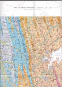 Bendigo Historical Society Inc.
Map - STRUGNELL COLLECTION: GEOLOGICAL SURVEY OF VICTORIA, BENDIGO GOLD FIELD - SPRING GULLY, 1987
... Map, Geological Survey of Victoria, Bendigo Gold Field... & Resources. Map, Geological Survey of Victoria, Bendigo Gold Field ...Map, Geological Survey of Victoria, Bendigo Gold Field - Spring Gully, Campaspe 10 000 2/1; Victoria 10,000.Cept. Of Industry, Technology & Resources.map, bendigo, spring gully gold field