Showing 1408 items
matching maroondah
-
 Ringwood and District Historical Society
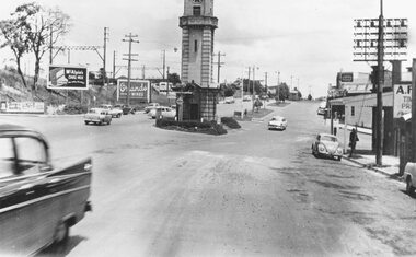
Photograph, Maroondah Highway Central, Ringwood. Clock tower at intersection of Warrandyte Road and Highway, c1960's
Black and white photograph (2 copies)Nil Image shows Maroondah Highway looking west from Warrandyte Road. -
 Ringwood and District Historical Society
Photograph, Maroondah Highway Central, Ringwood. Clocktower and Main Street, c1930.Postcard view of the clocktower and main street from the railway bridge above Warrandyte Road and Maroondah Highway, Ringwood - c.1930
Black and white photograph (2 copies)Typed below photograph: "Shops on right now Safeway site - c1930". Written on backing sheet of one photograph, "Original site of Ringwood Memorial Clocktower. Intersection Maroondah Highway and Warrandyte Rd." -
 Ringwood and District Historical Society
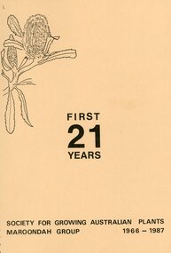
Booklet, "First 21 Years"- Society for Growing Australia Plants, Maroondah Group 1966-1987, 1966-1987
Spiral bound booklet of 77 pages titled "First 21 Years" Society for Growing Australia Plants, Maroondah Group 1966-1987. Introduction by Paul Kennedy, President at the time of printing. -
 Whitehorse Historical Society Inc.
Newspaper, Maroondah / Yarra Ranges Journal, 28/12/1999
'Celebrating the Century, Souvenir edition 1900 - 2000' of Maroondah / Yarra Ranges Journal. Includes information on Daniel Robertson Brickworks, Vermont - Mitcham Bus Service and Whitehorse and Mitcham Roads intersection.mitcham, whitehorse road, mitcham, mitcham road, mitcham, daniel robertson australia pty ltd, bus services -
 Ringwood and District Historical Society
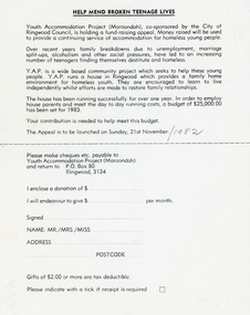
Flyer, Sheet - Appeal to raise money for destitute and homeless teenagers (Youth Accommodation Project Maroondah) - 1982, 21-Nov-82
Help mend Broken Lives was a Youth Accommodation project co-sponsored by the City of Maroondah. It was a fund raising appeal in 1983 for destitute and homeless teenagers.A single sheet printed with tear off lower half about appeal to raise money for destitute and homeless teenagers -
 Ringwood and District Historical Society
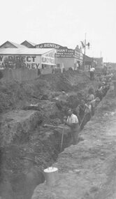
Photograph, Maroondah Highway East, Ringwood- c1920's. Excavation for new water main
Black and white photograph (2 copies- 1 large, 1 small)Written on rear of backing sheet: "Digging trench for water main along Maroondah Highway." -
 Ringwood and District Historical Society
Photograph, Maroondah Highway East, Ringwood- 1969. Looking west towards Ringwood from Mt Dandenong Road intersection
Black and white photographWritten on back of photograph: "Nov 1969, Cnr Mt Dandenong Road and Maroondah Highway." -
 Ringwood and District Historical Society
Photograph, Maroondah Highway East, Ringwood- 1969. Looking west towards Ringwood from Mt Dandenong Road
Black and white photographWritten on back of photograph: "Cnr Maroondah Highway and Mt Dandenong Road. Nov 1969." -
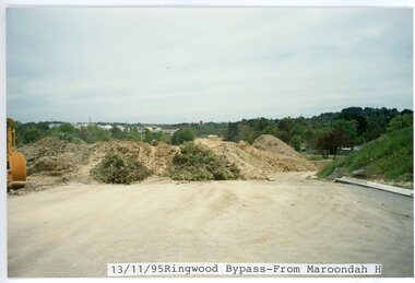 Ringwood and District Historical Society
photograph, Eastlink Ringwood Bypass Construction-Ringwood Bypass-from Maroondah Hwy 13/11/95
Colour photographWritten on back of photo: "Ringwood Bypass-from Maroondah Hwy 13/11/95" -
 Ringwood and District Historical Society
Photograph, Ringwood Motor Inn, Maroondah Highway, 1981
Written on back of photograph, "24/7/81. Ringwood Motor Inn, Maroondah Highway." -
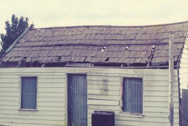 Ringwood and District Historical Society
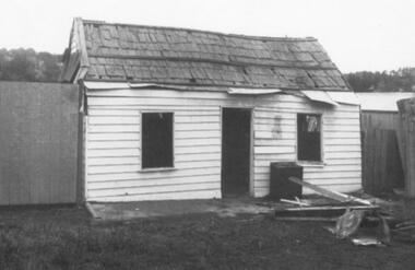
Photograph, Miner's residence at 367 Maroondah Highway, Ringwood. Built 1872, demolished 1975
Catalogue card reads, "367 Maroondah Highway, Ringwood. Built 1872, demolished 1975". -
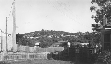
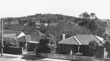 Ringwood and District Historical Society
Photograph, View from Maroondah Highway opposite Braeside Avenue towards Loughnan's Hill - 1973
View from Maroondah Highway opposite Braeside Avenue towards Loughnan's Hill - 1973. -
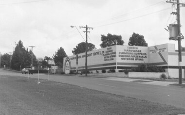
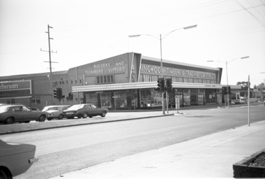 Ringwood and District Historical Society
Photograph, Maroondah Highway West, Ringwood- c1970. Ringwood Timber & Trading Builders and Plumbers Supplies
Black and white photograph (2 images)Ringwood Timber & Trading Builders and Plumbers Supplies on Maroondah Hwy cnr New St. -
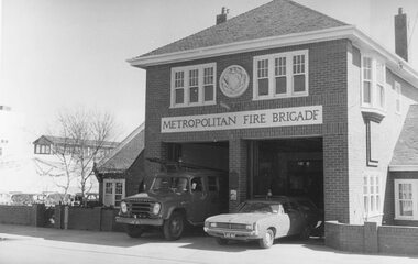 Ringwood and District Historical Society
Photograph, "Ringwood (Fire Station), Maroondah Highway 1973
Written on backing sheet, "Ringwood (Fire Station), Maroondah Highway 1973. Opened 1931" -
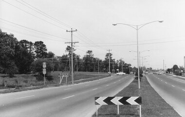
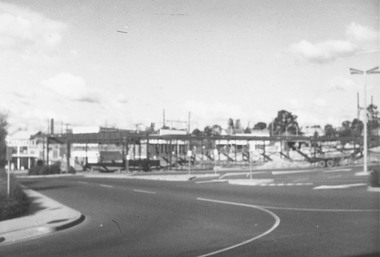
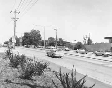 Ringwood and District Historical Society
Photograph, Maroondah Highway Central, Ringwood. View looking west from Warrandyte Road, 1974
Black and white photographWritten on rear of backing sheet: "Maroondah Highway near corner Warrandyte Rd., 1974". -
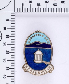 Melbourne Water
Souvenir lapel pin/brooch Maroondah Dam, 1960s/70s
Melbourne Water inherited many of its water assets, such as reservoirs from its predecessor the Melbourne Metropolitan Board of Works (MMBW). They have served the organisation well and have long been celebrated for both their natural beauty and engineering ingenuity. In the nineteenth century Victoria’s fundamental need for water infrastructure went beyond merely functional solutions and reflected the English ideal of the romance and beauty that was embodied in expanses of water. The MMBW further enhanced this notion by incorporating beauty and function in to the Classical and Italianate designs of its infrastructure such as pumping houses and reservoir outlet towers. The reservoir gardens and picnic areas were landscaped with ornamental stonework, exotic trees, decorative flower beds, fern glads pools and rose gardens. All features of the water supply system became widely celebrated as beauty spots that continue to be very popular to this day with tourists and locals alike. This souvenir is a product of that flourishing tourist trade. These water supply sites continue to enhance Melbourne’s charm and liveability and are now recognised as places of cultural and historic significance. This souvenir item has been curated by Melbourne Water as it represents an important historical aspect of the organisation by demonstrating the popularity of its water asset sites as recreational places and tourist attractions, and although these sites are functional parts of the water supply system, they were also designed to be enjoyed by the public both aesthetically and recreationally. Blue enamel and metal lapel pin/brooch depicting Maroondah Reservoir and outlet tower. Oval shaped with words 'Maroondah Dam' at the top and a ribbon banner containing 'Healesville' at the bottom. Maroondah Dam. Healesvillemelbourne metropolitan board of works, mmbw, maroondah reservoir, melbourne water, scenic view, souvenir, lapel pin, brooch -
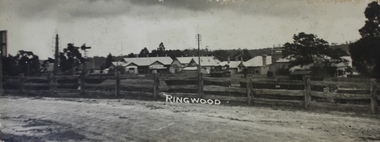 Ringwood and District Historical Society
Photograph, View of buildings on Maroondah Highway, Ringwood, taken overlooking railway yard from Station Street and Greenwood Avenue - 1914
Enlarged copy of smaller archived photograph - view of buildings on Maroondah Hwy taken overlooking railway yard from Station Street and Greenwood Avenue, 1914. Black and white photo on heavy cardboard backing. -
Whitehorse Historical Society Inc.
Document, Maroondah Halfway House Group, 1993 -1994
Papers of the Maroondah Halfway House GroupPapers of the Maroondah Halfway House Group including notice of the AGM Oct 1993 and proposed Special General Meeting Dec 1993, concerning the draft constitution of the MHHG; with correspondence and draft docs. regarding the constitution.Papers of the Maroondah Halfway House Groupmaroondah half way house group, plummer, jan, milton, joyce -
Ringwood and District Historical Society
Booklet, Feasibility Study of Town Hall Complex, Maroondah Hwy Ringwood - 1970
Used in the development of the Civic centre - pamphlets 1968. Feasibility study and report of the existing town hall complex at the corner of Maroondah Highway and Civic Place, Ringwood, April 19701. Report and feasibility study. Black 2-hole bound book with 22 inserted pages typrwritten.; 2. Bifold pamphlets with dark brown/sepia picture on front. Other pages printed. +Additional Keywords: Marshall, B R / Dwerryhouse, F P (Town Clerk) -
 Heidelberg Golf Club
Book, Melbourne Parks and Waterways, Lower Plenty River concept plan: Maroondah Pipe Track to Yarra River, 1994
Lower Plenty River concept plan: Maroondah Pipe Track to Yarra River. Includes suggestion of Plenty River Trail along the west boundary of the Heidelberg Golf Club.66 p., illus., colour map. Also, Draft copy of document.plenty river trail, lower plenty river, heidelberg golf club, mmbw, melbourne parks and waterways -
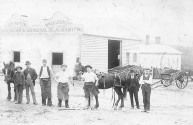 Ringwood and District Historical Society
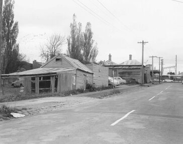
Photograph, Maroondah Highway Central, Ringwood. Workers outside D.R. Kennedy's blacksmith shop, corner of Adelaide Street and Maroondah Highway
2 photographs (1 large black and white, 1 small sepia)Typed under large photograph: "Originally Mr Tommy Grants smithy in Maroondah Hwy. Built 1880." David Robert Kennedy took over the business from Ringwood's original blacksmith mr Tommy Grant in 1894. -
 Ringwood and District Historical Society
Photograph, Corner Warrandyte Road and Maroondah Highway, Ringwood c1971
Blurry PhotographWritten on back of photograph, "Corner Warrandyte Road and Maroondah Highway, approximately 1971. Safeways Store". -
 Ringwood and District Historical Society
Photograph, Opposite end of Mines Road on Maroondah Highway, Ringwood. 1981
Written on back of photograph, "24/7/81. Opposite end of Mines Road on Maroondah Highway." -
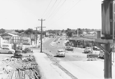 Ringwood and District Historical Society
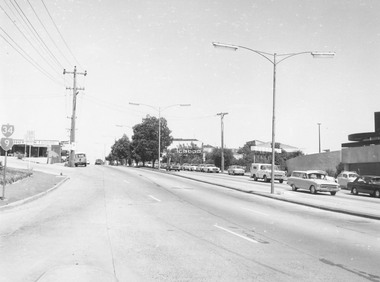
Photograph, Maroondah Highway West, Ringwood- 1960
Black and white photographWritten on back of photograph: "Maroondah Highway from cool store site - looking west, 1960". -
 Ringwood and District Historical Society
Photograph, Loughnan Hill from corner Maroondah Highway and Herbert Street, 1964
Written on backing sheet, "Loughnan Hill from corner Maroondah Highway and Herbert Street, 1964". -
 Ringwood and District Historical Society
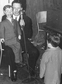
Photograph, Maroondah Pre-School Fete, 1960. Gerry Gee delights youngsters
Catalogue card reads, "Maroondah Pre-School Fete, 1960. Gerry Gee delights youngsters". -
 Ringwood and District Historical Society
Photograph, Dismantling of original Miners' Cottage in Maroondah Highway, Ringwood, prior to re-construction at Ringwood Lake c.1970s
Written on back of picture, "Original site in Maroondah Highway. Original Miners' Cottage being dismantled". -
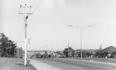
 Ringwood and District Historical Society
Photograph, Maroondah Highway Central, Ringwood. View looking west from Warrandyte Road - 1974
Black and white photographWritten on rear of backing sheet: "Maroondah Highway, 1974 - West from Warrandyte Rd. ext." -
 Ringwood and District Historical Society
Photograph, Maroondah Highway Central, Ringwood. Buildings at rear of property, N.E. corner of Adelaide Street and Maroondah Highway, 1963. (Eastland Litigation Photo), May 1963
This series of SS0380 photos are part of the "Eastland Litigation" launched in 1962 by the Whitehorse Traders Co-operative Association (WTCA), against the Ringwood Council's Interim Development Order of 1960. WTCA sought "orders from the Supreme Court of Victoria that the planning scheme was invalid" - See "The Eastland Litigation" chapter in "From Horse Shoes to High Heels - Ringwood Shopping Centre and Eastland 1858-2008" by Richard Carter, Bounce Books 2009.Black and White Photograph (2 copies)Written on back of photograph: "Photo showing buildings at rear of property, N.E. corner of Adelaide Street and Maroondah Highway". Stamps on back of photograph read, 'In the Supreme court, 13 Aug. 1963', and 'Edwin G. Adamson....May '63.' -
 Ringwood and District Historical Society
Photograph, Maroondah Highway West, Ringwood- c1920. Original Ringwood Market, Cnr. Maroondah Highway and Ringwood Street
Black and white photograph of wooden building. (2 copies)Typed under one copy: "Original Ringwood market and saleyards at corner of Maroondah Hwy and Ringwood St.. Charter St is beyond saleyards on right. SEC office now occupies site of buildings seen. c1920" Typed under second copy: "Original Ringwood market cnr Maroondah Highway and Ringwood St. opposite present clock tower site. 1920. Now SEC office. Sign on building reads- "Ringwood Market. D.G. McClelland & Co.. Stock Station Land Estate Agents. Alex McClelland, Auctioneer.