Showing 810 items matching "marsh"
-
 Bacchus Marsh & District Historical Society
Map, Bullengarook Parish, County of Bourke
An undated parish plan map for the parish of Bullegarook. This parish area is close to the Bacchus Marsh district and borders some of the areas contained within the former Bacchus Marsh Shire and present day Moorabool Shire.A single page paper map showing the parish plan map for Bullengarook. This parish area contains the locality of Bullengarook and parts of the Wombat State Forest and is close to the town of Gisborne. A cadastral map showing land ownership. The map is not dated but a very similar map held by the State Library of Victoria is estimated to date from about 1927. The map is pasted into a bound volume containing 76 maps or plans in total. High resolution digital image stored on BMDHS computer network. bullengarook parish maps -
 Greensborough Historical Society
Article, R. A. Marsh: Church Street Greensborough, by Faye Fort and June Hall, 1919_
A brief history of Richard Marsh and family and his house on the corner of Hailes and Church Street Greensborough. This story by Faye Fort and June Hall was updated in 2016 by Marilyn Smith and Sue Ballantyne from material generously supplied by Mrs Madge Marsh, widow of Richard's son Gordon.Story of a pioneer family and a significant house in Greensborough.One page of text.richard arthur marsh, teresa bautista, hailes street, marsh family -
 Bacchus Marsh & District Historical Society
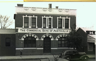
Photograph, Commercial Bank of Australia Main Street Bacchus Marsh
The Commercial Bank of Australia building was constructed by J. F. Taylor in 1907 and shortly after commenced operations as a bank. The building was in use as a CBA bank until 1976 when it was demolished and a new building erected. The CBA continued its operations at this location; subsequently, various banks, such as the Bank of Melbourne and Westpac operated there. Part of the new building is now in use as a newsagency. The original architectural plans for this building designed by Walter Butler are held by the State Library of Victoria and can be viewed online through the Library's website: Citation: Butler, W. R., & Taylor, J. F. (1906). Design for banking premises at Bacchus Marsh for the Commercial Bank of Australia Ltd. URL: http://handle.slv.vic.gov.au/10381/473561 Black and white photographic print. Photograph of the Commercial Bank 138 Main Street Bacchus Marsh. On the left is a smaller brick building adjoining the bank. On the right there is a partial shot of a shop called The House of Hodgson. The bank building itself is shown as a substantial two-story brick building, the top storey appearing to be a dwelling with three ornamented windows furnished with curtains and blinds. The storeys are divided by a white panel bearing the words "The Commercial Bank of Australia Ltd". The lower storey has a central entrance with a panelled door. The door is flanked by two windows with reinforced lattices. The windows and door are surmounted by decorative arches reminiscent of Spanish Moorish architecture. A car (possibly a 1937 Dodge) is parked on the street. A lone girl stands on the footpath waving at the photographer.On the back: In pencil: 1937 Dodge?shops bacchus marsh vic., main street bacchus marsh vic., banks bacchus marsh vic., commercial bank of australia bacchus marsh -
 Bacchus Marsh & District Historical Society
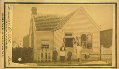
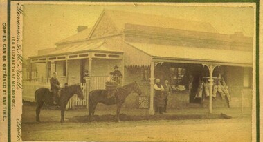
Photograph, Thomas Heath's Saddlery Main Street Bacchus Marsh 1883 Image 1
Thomas Heath built this shop for his saddlery business around 1875. In 1926 after 58 years operating his saddlery in Bacchus Marsh he retired and the assets of his business were sold in a clearing sale. The building was located close to the current day location of 192 Main Street and has been demolished. Apart from his services in saddlery his premises was known to be a gathering place for much discussion. Heath was known to openly express his political opinions and his saddlery premises was known by many in the community as the 'Parliament'.Small sepia unframed photograph on card with gold border framing photograph. Housed in the album, 'Photographs of Bacchus Marsh and District in 1883 by Stevenson and McNicoll'. The photo is of a double-fronted weatherboard building with a shingle roof. The front gabled section stands directly on street level and is flanked by a picket fence. The door and overhead window and the side window with arched panels may indicate that this was the shop section, with a dwelling to the rear. Items which may be for sale can be seen hanging in the windows. The recessed side section of the building with a twelve-sectioned window, chimney and a back extension was probably the dwelling used by the family. On the footpath stands the saddler with three children, two boys and an older girl, probably Mr Thomas Heath and three of his five children. A hitching rail runs along the front of the workshop. Indicating the type of business Mr Heath ran, are a saddle placed over the rail and two horse collars and reins hanging either side of the workshop door. On the front: Stevenson & McNicoll. Photo. 108 Elizabeth St. Melbourne. COPIES CAN BE OBTAINED AT ANY TIME. On the back: LIGHT & TRUTH inscribed on a banner surmounted by a representation of the rising sun. Copies of this Portrait can be had at any time by sending the Name and Post Office Money Order or Stamps for the amount of order to STEVENSON & McNICOLL LATE BENSON & STEVENSON, Photographers. 108 Elizabeth Street, MELBOURNE. saddleries, saddlers, thomas heath 1842-1930 saddler -
 Uniting Church Archives - Synod of Victoria
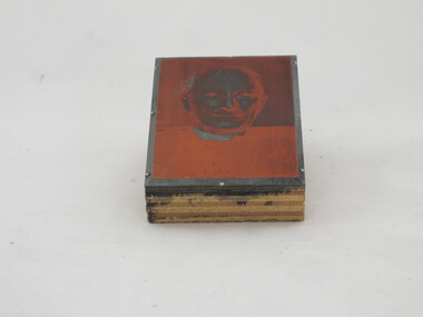
Photographic print block
Glen Iris Presbyterian Church on the corner of High Street and Allison Avenue. The foundation stone was laid by Prime Minister Mr R. G. Menzies and was opened on 21 November 1953. Head and shoulders image of Rev Marsh, Presbyterian minister.On back: "Rev [?] Marsh" "27"glen iris presbyterian church, marsh, rev -
 Tatura Irrigation & Wartime Camps Museum
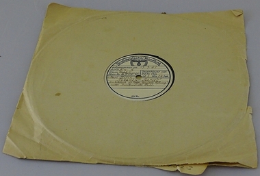
Record - gramaphone, Titanin-Marsh by composer Karl Stork, 1941
Possession of POW in Camp13 Murchison. Recording of Nazi wartime march. Title translates to "March of the Titans".Circular 78 musical record (German) WW2 on label in centre is written: Grossdeutscher Rundfunk above logo (Eagle over swastika), dated 13.3.41,"Titanin-Marsh" by composer Karl Stork. In brown paper sleeve. Recorddetails on separate paper slip64104Rtatura, musical, instruments, accessory -
 Bacchus Marsh & District Historical Society
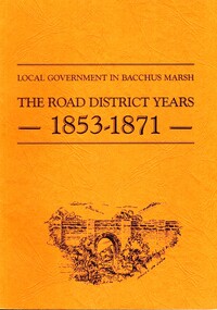
Book, John Lloyd, The Road District Years, 1853-1871: Local Government in Bacchus Marsh
This work describes the early evolution and history of local government in the Bacchus Marsh area. Local government bodies in Victoria and in other places had their origins in committees and local boards which were established to regulate over pressing local issues, raise revenue, and expend it in a limited range of social and economic ways. The early areas of responsibility were dominated by the need for local roads and this book primarily looks at this period of local government history in the Bacchus Marsh area. Overtime the range of areas local government bodies took responsibility for expanded and this work begins to trace this transformation in its earliest stages. It is a fascinating and detailed account of the early history of local government in Bacchus Marsh containing many amusing anecdotes among the wealth of administrative historical data. The author who was at one time an employee of the Shire of Bacchus Marsh has drawn directly from the early local records such as minutes of meetings, records of expenditure, newspaper reports and notices in the Victoria Government Gazette.Soft cover foolscap size book. 128 pages with b & w illustrations, maps and plans. No publisher is indicated in the work but it is likely to have been privately published by the author John Lloyd. Year and place of publication is 1986, Bacchus Marsh, Victoria.non-fictionThis work describes the early evolution and history of local government in the Bacchus Marsh area. Local government bodies in Victoria and in other places had their origins in committees and local boards which were established to regulate over pressing local issues, raise revenue, and expend it in a limited range of social and economic ways. The early areas of responsibility were dominated by the need for local roads and this book primarily looks at this period of local government history in the Bacchus Marsh area. Overtime the range of areas local government bodies took responsibility for expanded and this work begins to trace this transformation in its earliest stages. It is a fascinating and detailed account of the early history of local government in Bacchus Marsh containing many amusing anecdotes among the wealth of administrative historical data. The author who was at one time an employee of the Shire of Bacchus Marsh has drawn directly from the early local records such as minutes of meetings, records of expenditure, newspaper reports and notices in the Victoria Government Gazette.bacchus marsh shire council, local government bacchus marsh history -
 Melbourne Tram Museum
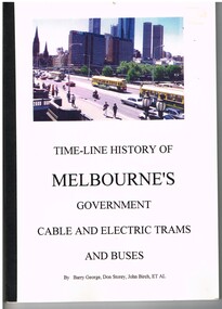
Book, Barry George, Don Storey, John Birch, Ray Marsh, "Time-line history of Melbourne's Government Cable and Electric Trams and Bus (timeline), 1997
Book - 130? pages - A4 - perfect bound with black binding tape on outside, colour printed card covers titled "Time-line history of Melbourne's Government Cable and Electric Trams and Buses", prepared by Barry George, Don Storey, John Birch with photographs by Ray Marsh. Gives a timeline history of Melbourne's government (with some private, VR) tramway and bus transport from 1868 to 1 October 1997 when the PTC was corporatised. Also gives opening and closing dates for each electric and cable line. Provides information on events on specific and approx. dates. See also Reg Item 840 for a similar 2003 document by Don Storey. See images 3 for pdf file - word searchable when opened as a separate file. timeline"Mike Ryan" in ink on top left hand corner of first page.trams, tramways, melbourne, history, mmtb, the met, ptc, cable trams, history -
 Bacchus Marsh & District Historical Society
Photograph, Edward's Butchers Shop Main Street Bacchus Marsh 1883
This Butcher’s shop was opened by J. Edwards. It adjoined G. Dickie’s bakery in Main Sreet. Later occupants of the premises included Beardmore, Clark, Bence and Ramsey.Small sepia 'carte de viste' style unframed photograph on card with gold border framing photograph. Housed in the album, 'Photographs of Bacchus Marsh and District in 1883 by Stevenson and McNicoll'. The image depicts a butcher’s premises in Main Street Bacchus Marsh. The butcher and another man stand on the verandah in front of the shop. Behind them meat for sale is seen hanging from a rack. Two other people stand under the verandah at the front of the dwelling which runs along the side of the shop. In the street are two other people, one of whom holds a delivery basket, mounted on horses.Printed On the front: Stevenson & McNicoll. Photo. 108 Elizabeth St. Melbourne. COPIES CAN BE OBTAINED AT ANY TIME. On the back: LIGHT & TRUTH inscribed on a banner surmounted by a representation of the rising sun. Copies of this Portrait can be had at any time by sending the Name and Post Office Money Order or Stamps for the amount of order to STEVENSON & McNICOLL LATE BENSON & STEVENSON, Photographers. 108 Elizabeth Street, MELBOURNE.stevenson and mcnicoll 1883 photographs of bacchus marsh and district, butchers, butcher shops -
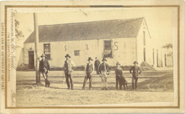
 Bacchus Marsh & District Historical Society
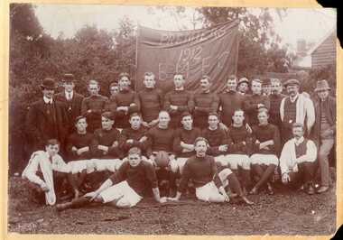
Photograph, Bacchus Marsh Football Club Premiers, 1912
This photo is one of the oldest known photographic records of an Australian Rules football team in the Bacchus Marsh area. Australian Rules football was played in this area as early as the 1870s. An organized competition to play regular matches was formed in the early years of the twentieth century. This photo records the premiership winning team of 1912 in the match played against Melton. The match was reported in the Bacchus Marsh Express of 31 August 1912. The names of the players are not recorded on this photo, but the Express records the names of Marsh, Fairbank, Northcott, Palmer, Roy Simpson, Morris, Tom Grant, Jack Taylor, Bert Jones, Portingale (c.), Densley Bros., Wittick, Harry Grant, Leonard, Odgers, Bodycote.This item has historic and social significance as an image of one of the early sporting teams of Bacchus Marsh and district. It is a typical example of team photographs of this era. It is evidence of the transition of football from a social informal setting to an organised activity and signals the growth of importance of sport, in this case Australian Rules football, as a cultural and social activity central to the Australian ethos.A sepia photograph print mounted on mounting board, showing a group of 27 men arranged in three rows in front of a banner reading PREMIERS 1912 BMFC. Eighteen men are in football guernseys, nine in civilian clothes, three of whom are carrying towels over their shoulders. One player, very likely the captain, is holding a football. The photo is taken in an outdoor setting. On the reverse in pencil: 'Middle row - 5th from left JOHN WITTICK.'bacchus marsh football club, australian rules football -
 Greensborough Historical Society
Photograph - Digital image, Marsh house 1973, 1973_
Richard Marsh's family home on the corner of Hailes and Church Street Greensborough, taken in 1973. (Copy made 31/10/2011)This is a significant house in Greensborough, still standing today.Digital copy of black and white photograph.richard marsh, marsh house, hailes street greensborough -
![Map, [Plan for road to give J. Allan access to permanent water at Coimadai] circa 1870s](/media/collectors/5e461d8021ea67224c82f2a1/items/67735190d671e67dd573a84c/item-media/6773533dd671e67dd573cd90/item-fit-380x285.jpg) Bacchus Marsh & District Historical Society
Bacchus Marsh & District Historical SocietyMap, [Plan for road to give J. Allan access to permanent water at Coimadai] circa 1870s
The date of this map or plan is uncertain but it appears to be from the early to mid 1870s. One of the landholders identified on the plan, James Allan of Coimadai died suddenly on the 9th July, 1874 (see Bacchus Marsh Express, 11 July, 1874, page. 3). There are mentions of an Allans Road at Coimadai in the Bacchus Marsh Express between 1887 and 1942.Single page map showing an excision of land belonging to Charles Ross which was selected to construct a road to give another landholder, J. Allan access to permanent water. Scale 1 chain to 1 inch. Part of a set of maps which are pasted into a bound volume containing 76 maps or plans in total. High resolution digital image stored on BMDHS computer network. Plan showing Excisions from Ross's selection and 1 chain road thro' the said selection in Coimadai to give J. Allan access to permanent water. Alistair ?? Shire Eng? 6?/5/7?coimadai victoria maps, coimadai roads and streets -
 Bacchus Marsh & District Historical Society
Photograph, Woolpack Stables Bacchus Marsh 1883
This image is one of a series of photographs taken by Melbourne based photographers Stevenson and McNicoll who visited Bacchus Marsh and its nearby districts between September and November 1883. James Elijah Crook settled in Bacchus Marsh in 1841 and soon after held a licence for a lodging house on the Portland Road. In about 1845, he built the first Woolpack Inn, a slab building of eight rooms. This was replaced in 1850 with a “stately country villa” of brick and stone. The stables were also built in 1850 to accommodate twenty horses. In 1851, Crook established a coach service to the goldfields. After being in use as a Court of Petty Sessions, the Woolpack Inn lost its licence and closed in 1862. After this date, Crook took an interest in horse-breeding and continued to use the stables for his horses. His most notable success was with his horse, Saladin, which won the Australia Cup in 1872, after two exciting dead-heats with The Flying Dutchman. James Elijah Crook died in 1889. The Woolpack Inn and Stables were sold and then used as a hay and corn store. In 1910 the site was leased for use as an abattoir. The Woolpack Inn was demolished in 1931. The site is still in use as an abattoir. Little remains of the original stables.Small sepia 'carte de viste' style unframed photograph on card with gold border framing photograph. Housed in the Jeremeas Family Album which contains photographs of Bacchus Marsh and District in 1883 by the photographers Stevenson and McNicoll. The photo is of a gable-roofed commercial stables with shingled roofing, and white-washed render to the walls, standing in a large cleared yard. There is a skillion extension to the south-west corner. On the front (northern) wall can be seen a door and three windows, two large and one small paned window in the centre. The eastern window is paned, while the western window has louvres and a pull-out blind. Three S shaped stays can be seen on the northern wall. Along the western wall are two more windows and doors. A mound of hay lies at the north-western corner. Standing at the front of the stables is a group of five men and two boys, one holding a large dog. Four of the men are dressed in workman’s clothing and some are holding tools of their trade. The man at the back is wearing more formal clothes and has distanced himself from the workmen. The pole against which one of the workmen is leaning appears to have damage along one side. This pole may have been used as a hitching post as there is a footrest installed lower down to make mounting easier. Printed On the front: Stevenson & McNicoll. Photo. 108 Elizabeth St. Melbourne. COPIES CAN BE OBTAINED AT ANY TIME. On the back: LIGHT & TRUTH inscribed on a banner surmounted by a representation of the rising sun. Copies of this Portrait can be had at any time by sending the Name and Post Office Money Order or Stamps for the amount of order to STEVENSON & McNICOLL LATE BENSON & STEVENSON, Photographers. 108 Elizabeth Street, MELBOURNE. stevenson and mcnicoll 1883 photographs of bacchus marsh and district -
 Bacchus Marsh & District Historical Society
Map, Plan of Survey of Part of Crown Allotment 9, Parish of Korkuperrimul, 1890
This map documents a transfer of an allotment of land in Clarke Street Bacchus Marsh in 1890. Clarke Street is located on the eastern side of Bacchus Marsh not far from Main Street and Crook Street. It is now known as Candeloro Street. The map indicates J. Booth as the owner of the land and H. Simpson as the occupier. Next to this allotment is a an allotment of land owned by J. Elmore,Single page map showing Crown allotment 9, Parish of Korkuperrimul, County of Bourke. Scale 100 feet to inch. Part of a set of maps which are pasted into a bound volume containing 76 maps or plans in total. High resolution digital image stored on BMDHS computer network. At bottom of map: I hereby certify that I have made this survey expressly for the purpose of an application under the Transfer of Land Statute that this plan is correct. Barry B???, Lic. Surveyor, 16.10.90bacchus marsh victoria maps, clarke street bacchus marsh maps -
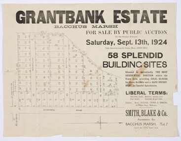 Bacchus Marsh & District Historical Society
Map - Land Sales Plan, Grantbank Estate Bacchus Marsh, 1924
The Grantbank Estate was a parcel of land close to the centre of the shopping area of Bacchus Marsh which was sub-divided and offered for sale in 58 lots on the 13th September, 1924. It comprised an area of 15 acres, being a portion of the Millbank Estate which had been in the hands of the Grant family for 75 years. The lots had frontages to Gisborne Road, Patterson, William and Sutherland Streets. This was a significant sub-division of land and represented a major expansion of residential housing in Bacchus Marsh in the early 20th century.This land sale map is a typical example of housing estate land sales advertising maps produced by real estate agents in this era. The map is significant for the detailed information it provides about when and where land was sold for new housing estates in Bacchus Marsh in the early twentieth century.Printed paper mapland sales bacchus marsh, land subdivsion bacchus marsh, housing estates land sales bacchus marsh, grant family bacchus marsh -
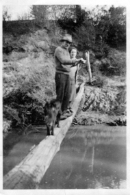 Greensborough Historical Society
Photograph - Digital image, Alan Partington and Teresa Marsh, 1940c
This image shows Alan Partington and Teresa Marsh on a log across the Plenty River at Greensborough. The log was the quickest access to Greensborough township from the Partington home at Willis Vale.Digital copy of black and white photograph.alan partington, teresa marsh, willis vale -
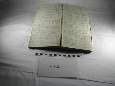 Blacksmith's Cottage and Forge
Book, Day, Day Book, 20 January 1920 to 27 April 1921
This book contains information relating to daily work conducted by Charles Edwards, Blacksmith, during period 20th January 1920 to 27 April 1921. It lists customer names, types of work done and costs involved. The written X indicates whether work was paid in full.This books contains historical information relating to peoples names and industries in the Bacchus Marsh district and the work performed for them by the blacksmith during the period mentioned. Most of work relates to shoeing horses, repairs to horse drawn vehicles, repairs to farm machinery/tools and some work on cars.Cardboard covers - green marbled design with black spine. Account type book with red ruled columns. Hand written names, jobs, charges and dates.On the inner cover - Mrs C Edwards, Main Street, Bacchus Marshbook, blacksmith, day, customers, clients, charles edwards -
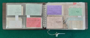 Bacchus Marsh & District Historical Society
Ephemera, Album of Assorted Bacchus Marsh Ephemera. Album 1
This album of ephemera contains a variety items such as invitations, tickets, brochures and cards for businesses and shops in Bacchus Marsh and district. The items range in date from the 1890s through to the late twentieth century. Vinyl and plastic covered album housing small card and paper ephemera items in plastic sleeves and pockets.bacchus marsh history, ephemera bacchus marsh, bacchus marsh social history -
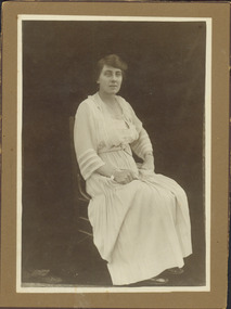 Kew Historical Society Inc
Photograph - Alice Maud Marsh
This photo of Alice Maud Marsh has traditionally been associated with the Marsh family that operated a butcher's shop on the corner of Edgevale Road and Fitzwilliam Street, Kew.Cabinet card. Studio portrait of Alice Marsh, J.E. Marsh whose family owned Marsh's Butcher Shop in Edgevale Road from 1915 to 1970. Previously the butcher shop had been owned by Mr Charlie Watson. Alice managed the shop until about 1928, when she became quite ill in about 1924 and died in 1930. The original donor, Nell Baker, who stated that .'..Alice could split lambs and breakup beef, no wonder she became ill!'BORN 29TH NOVEMBER 1877 / ALICE MAUD MARSH / DIED 2 JUNE 1930 / AGED (52) 52. Also photographed are two donation letters: that from Nell Baker to Mr Andrews [the current owner of the shop] in 1988, and from Diana Andrews [undated].alice maud marsh, marsh's butcher shop -- kew (vic.) -
 Bacchus Marsh & District Historical Society
Map, Gorrockburkchap Parish Map, County of Grant c.1906
The parish of Gorrockburkchap (sometimes spelled Gorrockburkghap) lies to the west and south west of the township of Bacchus Marsh. The locality of Rowsley is situated within this parish area.A single page paper map showing the parish plan for Gorrockburkchap in the County of Grant. A cadastral map showing parish boundaries and land ownership The map is pasted into a bound volume containing 76 maps or plans in total. High resolution digital image stored on BMDHS computer network. gorrockburkchap parish maps, rowsley victoria maps, bacchus marsh region parish plans -
 Bacchus Marsh & District Historical Society
Map, Gorrockburkchap Parish Map, County of Grant c.1915
The parish of Gorrockburkchap (sometimes spelled Gorrockburkghap) lies to the west and south west of the township of Bacchus Marsh. The locality of Rowsley is situated within this parish area.A single page paper map showing the parish plan for Gorrockburkchap in the County of Grant. The map is pasted into a bound volume containing 76 maps or plans in total. High resolution digital image stored on BMDHS computer network. gorrockburkchap parish maps, rowsley victoria maps -
 Bacchus Marsh & District Historical Society
Map, Gorrockburkchap Parish Map, County of Grant
The parish of Gorrockburkchap (sometimes spelled Gorrockburkghap) lies to the west and south west of the township of Bacchus Marsh. The locality of Rowsley is situated within this parish area.A single page paper map showing the parish plan for Gorrockburkchap in the County of Grant. The map is pasted into a bound volume containing 76 maps or plans in total. High resolution digital image stored on BMDHS computer network. gorrockburkchap parish maps, rowsley victoria maps -
Federation University Historical Collection
Book, Telstra, Telstra Telephone Book for Ballarat, Horsham, Bacchus Marsh, Ararat, Stawell and Daylesford, 2019
Telstra Telephone books gave names, addresses and telephone numbers for telephone subscribers in areas. This telephone book is for the 053 region which includes Ballarat, HOrsham, Bacchus Marsh, Ararat, Stawell and Daylesford. Soft covered telephone directory with White Pages and Yellow Pages.directory, ballarat, hepburn, telstra, horsham, bacchus marsh, ararat, daylesford, telephone directory, white pages, yellow pages, phone directory -
Federation University Historical Collection
Book, Telstra, Telstra Telephone Book for Ballarat, Horsham, Bacchus Marsh, Ararat, Stawell and Daylesford, 2019
Telstra Telephone books gave names, addresses and telephone numbers for telephone subscribers in areas. This telephone book is for the 053 region which includes Ballarat, HOrsham, Bacchus Marsh, Ararat, Stawell and Daylesford. Soft covered telephone directory with White Pages and Yellow Pages. Ekizabeth Verlinden on the cover.directory, ballarat, hepburn, telstra, horsham, bacchus marsh, ararat, daylesford, telephone directory, white pages, yellow pages, phone directory -
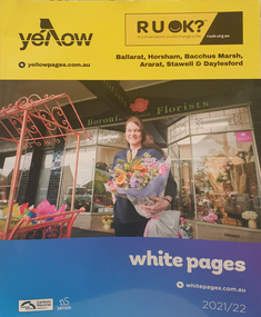 Federation University Historical Collection
Book, Telstra, Telstra Telephone Book for Ballarat, Horsham, Bacchus Marsh, Ararat, Stawell and Daylesford, 2021-2022
Telstra Telephone books gave names, addresses and telephone numbers for telephone subscribers in areas. This telephone book is for the 053 region which includes Ballarat, HOrsham, Bacchus Marsh, Ararat, Stawell and Daylesford. Soft covered telephone directory with White Pages and Yellow Pages. Boronia Florist on the cover.directory, ballarat, hepburn, telstra, horsham, bacchus marsh, ararat, daylesford, telephone directory, white pages, yellow pages, phone directory -
 Federation University Historical Collection
Book, Telstra, Telstra Telephone Book for Ballarat, Horsham, Bacchus Marsh, Ararat, Stawell and Daylesford, 2017-2018
Telstra Telephone books gave names, addresses and telephone numbers for telephone subscribers in areas. This telephone book is for the 053 region which includes Ballarat, HOrsham, Bacchus Marsh, Ararat, Stawell and Daylesford. Soft covered telephone directory with White Pages and Yellow Pages.directory, ballarat, hepburn, telstra, horsham, bacchus marsh, ararat, daylesford, telephone directory, white pages, yellow pages -
Federation University Historical Collection
Book, Telstra, Telstra Telephone Book for Ballarat, Horsham, Bacchus Marsh, Ararat, Stawell and Daylesford, 2008
Telstra Telephone books gave names, addresses and telephone numbers for telephone subscribers in areas. This telephone book is for the 053 region which includes Ballarat, HOrsham, Bacchus Marsh, Ararat, Stawell and Daylesford. Soft covered telephone directory with White Pages and Yellow Pages.directory, ballarat, hepburn, telstra, horsham, bacchus marsh, ararat, daylesford, telephone directory, white pages, yellow pages -
Federation University Historical Collection
Book, Telstra, Telstra Telephone Book for Ballarat, Horsham, Bacchus Marsh, Ararat, Stawell and Daylesford, 2015
Telstra Telephone books gave names, addresses and telephone numbers for telephone subscribers in areas. This telephone book is for the 053 region which includes Ballarat, HOrsham, Bacchus Marsh, Ararat, Stawell and Daylesford. Soft covered directory with White Pages and Yellow Pages. The cover features Federation University of Ballarat staffmember, Ellen Sabo, and two student mentors under the 'tree of Knowledge'.directory, ballarat, hepburn, telstra, horsham, bacchus marsh, ararat, daylesford, telephone directory, white pages, yellow pages, ellen sabo, student mentors, tree of knowledge, federation university, mt helen campus -
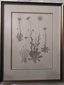 Glenelg Shire Council Cultural Collection
Drawing, Collin Elwyn Woolcock, Brachycome radicans (Marsh Daisy)/Brachycome scapigera (Tufted Daisy)/Brachycome diversifolia (Tall Daisy)/Brachycome tenuiscapa (var. tenuiscapa) (Mountain Daisy), 1985
Part of "Woolcock Gallery Collection" Exhibition, 1989, CEMA.Four studies of flowers, complete from base to flower. On far left is a single stem flower with many petals and a large centre. The base has many long tapered leaves, with the stem possessing smaller leaves. On left of this study is a study of a seed. To the right of this is another flower - similar to the first flower, but with stronger base leaves and one leaf on stem. Central flower study has three stems with leaves and flowers (central flower is a bud). Leaves are ripple-edged. On far right is a fourth flower study - single-stemmed flower with ripple-edged leaves at base and up the stalk.Front: Brachycome radicans (Marsh Daisy). " scapigera (Tufted Daisy). " diversifolia (Tall Daisy). " tenuiscapa (var. tenuiscapa) Mountain Daisy) (lower left) (pencil). CEW/85 (pen) (lower centre) Back: 25cema, botanical, collin woolcock