Showing 177 items matching "mullum mullum creek"
-
 Ringwood and District Historical Society
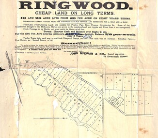
Flyer, Land Sale Advertisement, Ringwood, Victoria - 1894
Land sale advertisement for 10 and 20 acre lots from £5 per acre on eight years' terms in Ringwood, with description of local facilities and agricultural features.Subdivision map includes Mullum Mullum Road, Wonga Road, Oban Road and Anderson's Creek Road (later Warrandyte Road). Markings on reverse side indicate the sheet was sent by post from John McEwan & Co., Auctioneers, Land Agents & Business Brokers, 71 Swanston Street, Melbourne, to Mr Allan, Builder, Ringwood, postmarked in JE (June), 1894. -
 Ringwood and District Historical Society
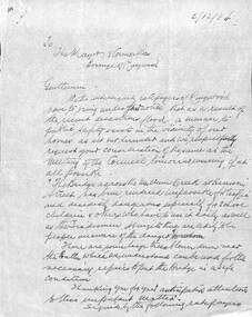
Document, Council flood relief for Mullum Creek flood in Ringwood in 1934
... Council flood relief for Mullum Creek flood in Ringwood in... of Harrison Street bridge over Mullum Creek in 1934.... in the vicinity of Harrison Street bridge over Mullum Creek in 1934. Hand ...Hand written letters to Ringwood Council re flood relief.Correspondence to Council from Ratepayers asking for flood relief resulting from the flood damage in the vicinity of Harrison Street bridge over Mullum Creek in 1934. -
 Ringwood and District Historical Society
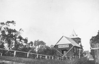
Photograph, C of E jambed on bridge over Mullum Creek, W'dyte Rd. Ringwood 1924
... C of E jambed on bridge over Mullum Creek, W'dyte Rd... over Mullum Creek, W'dyte Rd. 1924." Typed below another copy... of E jambed on bridge over Mullum Creek, W'dyte Rd. 1924 ...Written on back of photograph, "C of E jambed on bridge over Mullum Creek, W'dyte Rd. 1924." Typed below another copy: "Moving Church of England, Ringwood. Stuck on bridge over Mullum Creek in Warrandyte Rd. 1924". Written on backing sheet, "Church of England being moved from C/r Pratt Street and Maroondah H'way to rear post office via Warrandyte Rd., Reynolds Av. and Ringwood Street." -
 Ringwood and District Historical Society
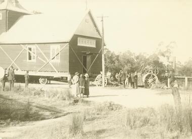
Photograph, Ringwood Church of England stuck on Warrandyte Rd. bridge over Mullum Creek whilst being removed - 1924
... over Mullum Creek whilst being removed - 1924.... Mullum Creek whilst being removed - 1924. Photograph ...Black and white photograph of building, steam-roller in front.Written on backing sheet, "C of E stuck on W'dyte Rd. bridge over Mullum Ck. whilst being taken from C.r Main & Pratt Sts. to new site in Ringwood St. 1924" -
 Ringwood and District Historical Society
Photograph, Church of England relocation: About to cross bridge over Mullum Creek, Warrandyte Rd (undated)
... Mullum Creek, Warrandyte Rd (undated)... over Mullum Creek, Warrandyte Rd. English Church" Appears... to cross bridge over Mullum Creek, Warrandyte Rd. English Church ...Smaller photograph that appears to be the original from which this photograph was taken reads, "About to cross bridge over Mullum Creek, Warrandyte Rd. English Church" Appears to be Church of England. -
 Ringwood and District Historical Society
Photograph, Addison home 1902 Ringwood in background
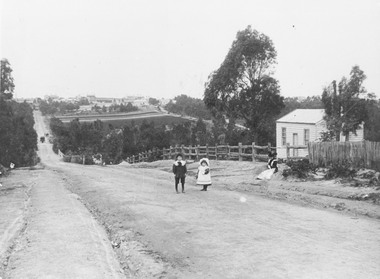
... . Adelaide St. seen on right of it. Mullum Creek Bridge at foot... in background. Maroondah Highway at top of hill with Mullum Creek bridge ...Black and white photograph of scene showing unmade road with two children, a boy and a girl standing outside a small wooden building. Lady is sitting by the side of road. Road dips down to a bridge then rises again towards distant settlement in background. (3 copies)Typed below enlarged photo, "Addison home, 1902 - Opposite present St. Paul's, Warrandyte Road". Written on backing sheet, "Andersons Creek Rd. 1903. Mrs. Addison (Annie Kennedy) and family - Annie, born 1897 and William. Their house at right was on a 5 acre block. Ringwood in background". Backing sheet of another copy reads, "Andersons Creek Road 1902 (Warrandyte Rd. looking south). Mrs. Addison (Annie Kennedy) and family. Annie (Jnr), born 1897 and Samuel John James William, born 1894. Their home, at right, was on a 5 acre block. Ringwood in background - burned down by pet magpie. T. Grant's land ploughed - now Eastland. Adelaide St. seen on right of it. Mullum Creek Bridge at foot of hill". Typed below this photograph, "Warrandyte Rd. Ringwood looking south from near Mullum Rd. Ringwood in background. Maroondah Highway at top of hill with Mullum Creek bridge seen in dip - 1902". -
 Ringwood and District Historical Society
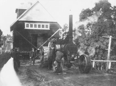
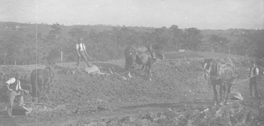
Photograph, Roadmaking by McGiverns. Warrandyte Rd. just north of Mullum Creek. 1920s
... Mullum Creek. 1920s..... Warrandyte Rd. just north of Mullum Creek". Written on backing sheet..., "Roadmaking by McGiverns. Warrandyte Rd. just north of Mullum Creek ...Typed below photograph, "Roadmaking in Ringwood in the 1920s". Catalogue card reads, "Roadmaking by McGiverns. Warrandyte Rd. just north of Mullum Creek". Written on backing sheet, "McGiverns of Croydon in Andersons Creek Road". -
 Ringwood and District Historical Society
Photograph, Roadmaking by McGivens, Warrandyte Rd. just north of Mullum Creek. Easier to camp on job rather than take horses and machinery to and from Croydon. 1920s
... Roadmaking by McGivens, Warrandyte Rd. just north of Mullum..., Warrandyte Rd. just north of Mullum Creek. Easier to camp on job..., "Roadmaking by McGivens, Warrandyte Rd. just north of Mullum Creek ...Typed below photograph, "Roadmaking in Ringwood in the 1920s." Catalogue card reads, "Roadmaking by McGivens, Warrandyte Rd. just north of Mullum Creek. Easier to camp on job rather than take horses and machinery to and from Croydon." -
 Ringwood and District Historical Society
Photograph, Playing space corner Ringwood St. and Reynolds Ave. Ringwood, alongside Mullum Creek. 1973
... . Ringwood, alongside Mullum Creek. 1973.... and Reynolds Ave. alongside Mullum Creek." 7/73... Mullum Creek." 7/73 Playing space corner Ringwood St ...Written on backing sheet, "Playing space corner Ringwood St. and Reynolds Ave. alongside Mullum Creek." 7/73 -
 Ringwood and District Historical Society
Photograph, Looking to Adelaide St. from Reynolds Ave. Ringwood (across Mullum Creek) 1973. Site of bridge washed away in floods 1931. Infant Welfare Centre (Dr. Hewitts) on right
... Mullum Creek) 1973. Site of bridge washed away in floods 1931... Reynolds Ave. (across Mullum Creek) 1973. Site of bridge washed... to Adelaide St. from Reynolds Ave. (across Mullum Creek) 1973. Site ...Black and white photographCatalogue card reads, "Looking to Adelaide St. from Reynolds Ave. (across Mullum Creek) 1973. Site of bridge washed away in floods 1931. Infant Welfare Centre (Dr. Hewitts) on right." -
 Whitehorse Historical Society Inc.
Article, VicRoads angers Greens, 1994
The Opposition and Koonung Mullum Forestway Association have claimed VicRoads has started removing protected vegetation.The Opposition and Koonung Mullum Forestway Association have claimed VicRoads has started removing protected vegetation along the Koonung Valley without a valid permit from the Department of Conservation and Natural Resources. Koonung Mullum Forestway Association are holding a protest rally.The Opposition and Koonung Mullum Forestway Association have claimed VicRoads has started removing protected vegetation. clubs and associations, koonung mullum forestway association, victoria. department of conservation and natural resources, pullen, barry, vicroads, eastern freeway -
Whitehorse Historical Society Inc.
Article, Bypass Plan Disastrous, 4/12/1991 12:00:00 AM
Public meeting held to demand that the State Government implement package of alternatives and proposed extension to preserve Koonung and Mullum Mullum Valleys.Public meeting held to demand that the State Government implement package of alternatives and proposed extension to preserve Koonung and Mullum Mullum Valleys.Public meeting held to demand that the State Government implement package of alternatives and proposed extension to preserve Koonung and Mullum Mullum Valleys.freeways, koonung mullum forestway association, public transport users association of victoria, conservation council of victoria, hartwell, ross, spyker, peter -
Whitehorse Historical Society Inc.
Article, Concern At Road Plans, 15/01/1997 12:00:00 AM
The Koonung Mullum Freeway Association calls for postponement of finalisation of 10 year north eastern regional road strategy.The Koonung Mullum Freeway Association calls for postponement of finalisation of 10 year north eastern regional road strategy until return of elected Councillors on 15th March 1997.The Koonung Mullum Freeway Association calls for postponement of finalisation of 10 year north eastern regional road strategy.freeways, koonung mullum forestway association, vicroads, city of whitehorse -
Whitehorse Historical Society Inc.
Document, Mullum Mullum Valley
A laminated poster depicting an original water colour by Christine Bever, June 1999.A laminated poster depicting an original water colour by Christine Bever, June 1999, produced by the Australian Conservation Foundation of the Mullum Mullum Valley.A laminated poster depicting an original water colour by Christine Bever, June 1999. mullum mullum valley, conservation -
Whitehorse Historical Society Inc.
Article, Giant digger takes first bite of our new tunnel, 2005
Article on the digging of the Eastlink tunnel through the Mullum Mullum Valley, and political controversy over road tolls.Article on the digging of the Eastlink tunnel through the Mullum Mullum Valley, and political controversy over road tolls. Photo of worksiteArticle on the digging of the Eastlink tunnel through the Mullum Mullum Valley, and political controversy over road tolls. east link eastern freeway extension, tunnel -
Whitehorse Historical Society Inc.
Article, The Drill to protect valley, 2005
First of four road-headers started drilling at Mitcham Road end of Mullum Mullum Valley tunnel, with photo.First of four road-headers started drilling at Mitcham Road end of Mullum Mullum Valley tunnel, with photo.First of four road-headers started drilling at Mitcham Road end of Mullum Mullum Valley tunnel, with photo.mitcham road, mitcham, eastlink, mullum mullum valley, aubrey, chris, batchelor, peter -
Whitehorse Historical Society Inc.
Document, Tunnel ventilation system, 1/03/2006 12:00:00 AM
... Whitehorse Historical Society Inc. 2-10 Deep Creek Road ...Tunnel ventilation system works approval application summary document.Tunnel ventilation system works approval application summary document.Tunnel ventilation system works approval application summary document.mullum mullum tunnel, eastlink -
Whitehorse Historical Society Inc.
Article, Tollway runs along on track, 2006
... Whitehorse Historical Society Inc. 2-10 Deep Creek Road ...Article on Eastlink project construction, including three photos.Article on Eastlink project construction, including three photos.Article on Eastlink project construction, including three photos.mullum mullum tunnel, eastlink -
Whitehorse Historical Society Inc.
Article, State park for our border, 2006
City of Whitehorse to have a state-controlled park at its border under a plan for Mullum Mullum Valley.City of Whitehorse to have a state-controlled park at its border under a plan for Mullum Mullum Valley.City of Whitehorse to have a state-controlled park at its border under a plan for Mullum Mullum Valley.city of whitehorse, state parks, mcinnes, ken, falkingham, cecily, friends of mullum mullum valley -
Whitehorse Historical Society Inc.
Letter - Correspondence, Mullum Mullum Park, 1/11/2006 12:00:00 AM
... Whitehorse Historical Society Inc. 2-10 Deep Creek Road ...Letter from Tony Robinson, MP to RC & BJ Gardiner about the formation of the new Mullum Mullum Park; aerial photo of the area on verso.Letter from Tony Robinson, MP to RC & BJ Gardiner about the formation of the new Mullum Mullum Park; aerial photo of the area on verso.Letter from Tony Robinson, MP to RC & BJ Gardiner about the formation of the new Mullum Mullum Park; aerial photo of the area on verso.mullum mullum park, tony robinson -
Whitehorse Historical Society Inc.
Map, Proposed Mullum Mullum Park, 6/05/2008
... Whitehorse Historical Society Inc. 2-10 Deep Creek Road ...Map produced by Parks Victoria.Map produced by Parks Victoria.Map produced by Parks Victoria.mullum mullum park, maps -
Whitehorse Historical Society Inc.
Pamphlet - Newsletter, Koonung Mullum Forestway Association, 1989
Special Newsletter December 1989.Special Newsletter December 1989. A Panel of Review for the Eastern Arterial Road and Ringwood bypass has asked for submissions for Public hearings.Special Newsletter December 1989. koonung mullum forestway association, ringwood bypass -
Whitehorse Historical Society Inc.
Article, Path invasion furore, 2005
Greenlink Box Hill Inc. objects to the planned path along Mullum Mullum Valley (photo).Greenlink Box Hill Inc. objects to the planned path along Mullum Mullum Valley (photo).Greenlink Box Hill Inc. objects to the planned path along Mullum Mullum Valley (photo).greenlink box hill inc., falkingham, reg, pell, brian, kemm, garry -
Whitehorse Historical Society Inc.
Article, Valley track alarm, 2005
Brian Pell, a member of Greenlink Box Hill Inc. and Yarran Dheran Advisory Committee objects to a path through the middle of Mullum Mullum Valley (photo).Brian Pell, a member of Greenlink Box Hill Inc. and Yarran Dheran Advisory Committee objects to a path through the middle of Mullum Mullum Valley (photo).Brian Pell, a member of Greenlink Box Hill Inc. and Yarran Dheran Advisory Committee objects to a path through the middle of Mullum Mullum Valley (photo).pell, brian, mullum mullum valley, greenlink box hill inc, yarran dheran advisory committee -
 Whitehorse Historical Society Inc.
Functional object - Butter Churn
Believed to have been owned originally by Alice and Arthur Fisher who had a 16 acre property in Mullum Mullum Road, Ringwood. The house was called Greenhill and was located at the highest point, now no. 28. They had a mixed farm including an orchard of fruit and nut trees, and a dairy cow. Alice milked the cow much to the amusement of her English family, who delighted in visiting. When the property was sold the butter churn went to Red Hill on the Mornington Peninsula. Arthur Lunt, donor has memories of its use in Red Hill, where his parents had a mixed farm. That property was sold c. 1950, and the butter Churn returned to the Ringwood Croydon area where it has remained unused for the last 65 years.|The butter churn has been in Croydon and Ringwood since 1952; it is typical of manually operated equipment in use on small properties 100 years ago.Cylindrical container, brown, mounted on board with handle underneath. To one side is a wooden handle and drive gears to spin cylinder. Cylinder has tight fitting lid and makers metal label on the side; opposite side has direction arrow embossed. Mounted on wooden base. Cream was put into churn, handle turned to spin drum until butter was produced. Five parts to the Churn.SVENSKA STOCKHOLM SWEDEN CENTRIFUGA,B.DAHLIA N0:0 SLATER PATENTdomestic items, food preparation -
 Whitehorse Historical Society Inc.
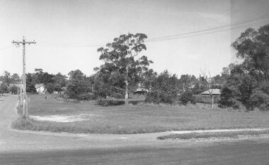
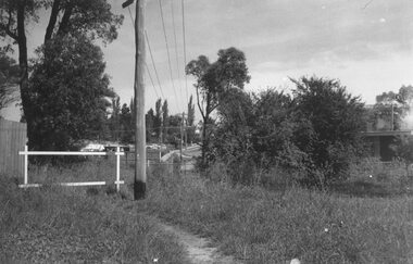
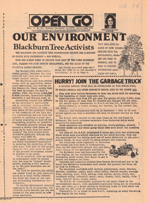
Newspaper, Open Go, 1/12/1976 12:00:00 AM
... mullum mullem creek... preservation society mullum mullem creek koonung mullum forestry ...Periodical published under the Australian Assistance Plan and edited by Morna Sturrock, includes material on use of land next to Blackburn Lake, Koonung Mullum Forestway and along the route of the Eastern Freewayenviroment, blackburn & district tree preservation society, mullum mullem creek, koonung mullum forestry association, eastern freeway -
 Whitehorse Historical Society Inc.
Map - Parish Map, Parish of Nunawading, 1892
... to the south, Mullum Mullum Creek and Dandenong Creek to the east ...A map copied from 'Directory maps - parishes and counties' dated 26 Nov 1892. Compiled and lithographed by G.S. Bonney. The map includes roads, railway, stations, names of property owners. It has a scale [ca. 1:31,680] 40 chains to an 1 inch.A map copied from 'Directory maps - parishes and counties' dated 26 Nov 1892. Compiled and lithographed by G.S. Bonney. The map includes roads, railway, stations, names of property owners. It has a scale [ca. 1:31,680] 40 chains to an 1 inch.non-fictionA map copied from 'Directory maps - parishes and counties' dated 26 Nov 1892. Compiled and lithographed by G.S. Bonney. The map includes roads, railway, stations, names of property owners. It has a scale [ca. 1:31,680] 40 chains to an 1 inch.maps, parish of nunawading