Showing 233 items
matching old post office hill
-
 Ballarat Heritage Services
Document - Database, Ballarat Old Cemetery Burials 1848-1856
... Ballarat Heritage Services PO Box 2209 Bakery Hill Post ...Xl Database of burials at Ballarat transcribed by Ian Wilcox and Dorothy Wickham from the death registers at the Office of BDMs. 1168 entries.ballaarat old cemetery, burials -
Ballarat Heritage Services
Document - Database, Dorothy Wickham, Ethersay's Book Ballarat Old Cemetery, 1994
Dorothy Wickham Researcher BDGS transcribed burials for Ballarat that were prior to the Cemetery Records that started in 1856. Burials as written transcribed from Ethersay's Burial Register, Ballarat Old Cemetery. 99 burialsballaarat old cemetery, burials, ethersay, early burials -
 Ballarat Heritage Services
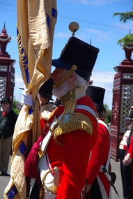
Photograph - Photograph - Colour, 40th Regiment Reenactors at the Ballaarat Old Cemtery, Eureka Sunday, 2013, 30/11/2013
Colour photographs of re-enactors of the 40th regiment the Ballaarat Old Cemetery on Eureka Sunday. eureka sunday, 40th regiment, ballaarat old cemetery, military, eureka stockade, eureka commemoration -
 Ballarat Heritage Services
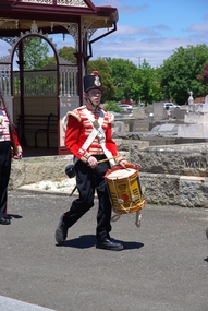
Photograph - Colour, Clare Gervasoni, 40th Regiment 'Drummer Boy' at the Ballaarat Old Cemtery, Eureka Sunday, 2013, 2013
Colour photographs of a re-enactor of the 40th Regiment Drummer Boy the Ballaarat Old Cemetery on Eureka Sunday. eureka sunday, 40th regiment, ballaarat old cemetery, military -
 Ballarat Heritage Services
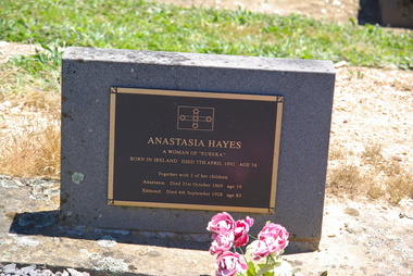
Photograph - Photograph - Colour, Clare Gervasoni, Anastasia Hayes Gravestone at the Ballaarat Old Cemtery, Eureka Sunday, 2013, 2013
Colour photographs of Anastasia Hayes Headstone in the Ballaarat Old Cemetery . 40th regiment, ballaarat old cemetery, anastasia hayes, women of eureka, eureka stockade -
 Ballarat Heritage Services
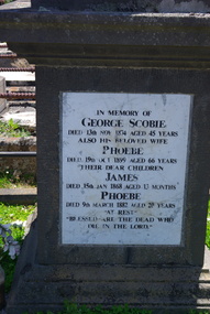
Photograph - Colour, Clare Gervasoni, Scobie Gravestone at the Ballaarat Old Cemetery, 2013, 2013
... Ballarat Heritage Services PO Box 2209 Bakery Hill Post ...Colour photographs of the Scobie headstone in the Ballaarat Old Cemetery . ballaarat old cemetery, george scobie, phoebe scobie, james scobie, eureka stockade -
 Ballarat Heritage Services
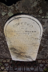
Photograph - Photograph - Colour, Clare Gervasoni, Brophy Gravestone at the Ballaarat Old Cemetery, 2013, 2013
... Ballarat Heritage Services PO Box 2209 Bakery Hill Post ...Colour photographs of the Brophy headstone in the Ballaarat Old Cemetery . ballaarat old cemetery, eureka stockade, daniel brophy, ellen brophy, bartholomew brophy, ellen maria brophy, james henry brophy, thomas edward brophy, mary berkery, daniel patrick brophy, william brophy -
 Ballarat Heritage Services
Digital photograph, Dorothy Wickham, Border Collie dog, 2018
Border Collie dog sitting in a puddle. This is a two year old pure bred border collie called Ella.border collie, dog -
 Ballarat Heritage Services
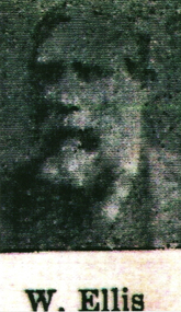
Photograph - Digital photograph, William Ellis
William Ellis was related to John Gillies Waite Ellis who was named after the captain of the vessel that brought the family to Australia. He went to New Zealand and established Homes there before returning to Victoria. He went to school at Redan and was an Old Scholar there.An image of William Ellis as reproduced in a Ballarat newspaperwilliam ellis, john elis, john gillies waite ellis, redan stat school, new zealand, redan, sebastopol -
 Ballarat Heritage Services
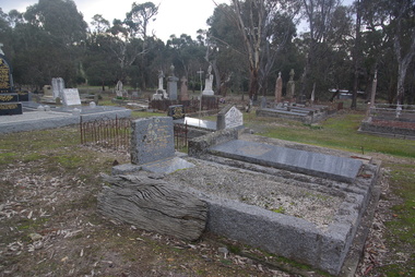
Photograph - Colour, Clare Gervasoni, Sandon Cemetery, 2017, 16/07/2017
Colour photograph of a section of the Sandon Catholic Cemetery. On old timber headstone rests on another headstone. sandon, sandon cemetery, timber headstone, sandon catholic cemtery -
 Ballarat Heritage Services
Photograph - Colour, Knowth and New Grange, Ireland, World Heritage Centre
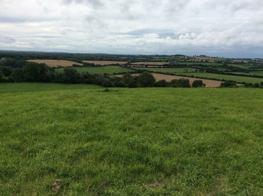
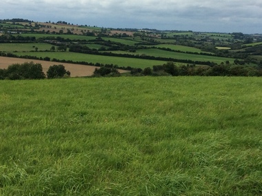
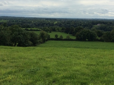
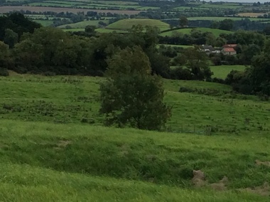
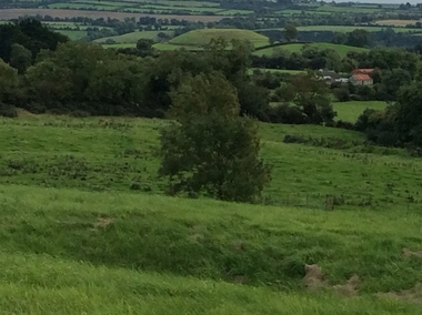
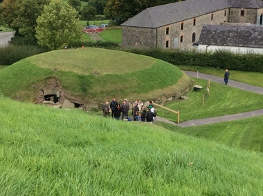
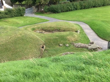
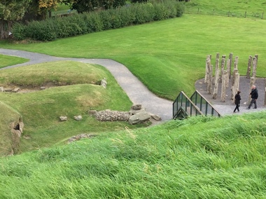
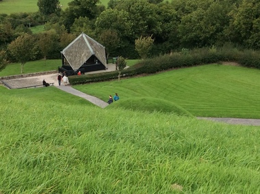
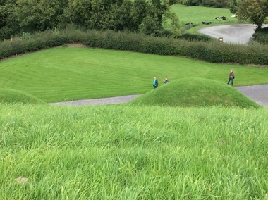
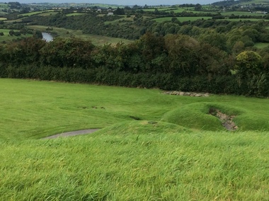
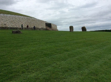
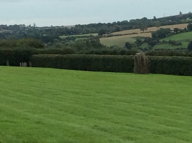
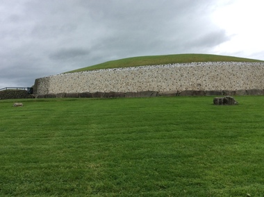
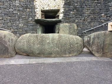
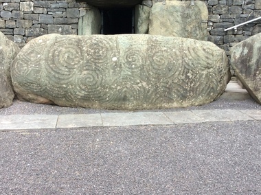
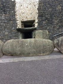
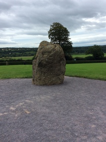
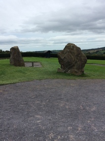
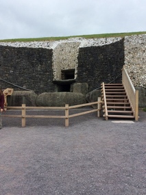
The Megalithic Passage Tombs of Newgrange, Knowth, Dowth, Fourknocks, Loughcrew and Tara are located in the present day County Meath in Ireland's Ancient East. The Boyne Valley Mounds at Newgrange, Knowth and Dowth were built around 3200BC making them older than Stonehenge in England and the Pyramids of Giza in Egypt. Built by Neolithic farming communities about 5000 years ago, the passage tombs have clear astronomical alignments such as the Winter Solstice Sunrise at Newgrange and the Equinox Sunrise at Loughcrew. Judging from the splendour and magnificence of Newgrange and Knowth it is likely that these temples of the ancestors were places of astrological, spiritual, religious and ceremonial importance, much as present day cathedrals are places of worship where dignitaries may be laid to rest. There is a lively debate about whether these wonderful megalithic structures were built primarily as burial tombs, sacred temples or astronomical observatories. While passage tomb is the traditional description for Newgrange and similar structures, chambered cairn or passage mound are the descriptions favoured by those who consider the passage tomb description too narrow. The large stones surrounding and inside the Passage Tombs are decorated with Megalithic Art such as spirals, concentric circles, triangles, zigzags and images which have been interpreted as the sun, moon and the human face. Irish passage tombs tend to occur in clusters traditionally described as a Necropolis or cemetery. The Boyne cluster includes Newgrange, Knowth, Dowth and Townleyhall. The other great clusters in County Meath are on the hills around Loughcrew. The ancient Boyne Valley passage tomb mounds at Newgrange, Knowth and Dowth have been designated World Heritage Site status by UNESCO and attract 200,000 visitors per year. The sites and Visitor Centre are managed by the OPW (Office of Public Works). Newgrange is best known for the illumination of its passage and chamber by the winter solstice sun. The site is open to the public with controlled access to the passage and chamber. Tours of Newgrange start at the Brú na Bóinne Visitor Centre located near the village of Donore, Co. Meath. Knowth has two passages and is surrounded by seventeen satellite cairns. The site is open to the public; however there is no public access to the interior passages and chambers. Tours of Knowth also start at the Brú na Bóinne Visitor Centre. Dowth is the only one of the three large Brú na Bóinne Passage Tombs which is not accessible from the Visitor Centre situated on the south bank of the river. Visitors to Dowth must drive directly to the site on the north bank, a couple of miles from the Slane / Drogheda road. Fourknocks with its short passage leading into a wide pear shaped chamber is in similar style to Tombs in Portugal. Just inside the main chamber to the left of the entrance is one of the few representations of a human face from the Neolithic Period in ancient Ireland. Entrance to Fourknocks Megalithic Passage Tomb. Megalithic Art - Loughcrew, Co. Meath Loughcrew Cairns form the largest complex of Megalithic structures in Ireland. The Cairns contain symbolic engravings similar in style to Newgrange. Like other Passage Tombs in ancient Ireland, they have clear astrological alignments.Tara was the seat of the High Kings of Ireland in the first millennium A.D. however Tara is also the site of a Passage Tomb known as the Mound of the Hostages that was built about 2,500 B.C. knowth, newgrange, megalith, ireland, world heritage, neolithic -
 Ballarat Heritage Services
Photograph - Colour, Knowth and New Grange, Ireland, World Heritage Centre
The Megalithic Passage Tombs of Newgrange, Knowth, Dowth, Fourknocks, Loughcrew and Tara are located in the present day County Meath in Ireland's Ancient East. The Boyne Valley Mounds at Newgrange, Knowth and Dowth were built around 3200BC making them older than Stonehenge in England and the Pyramids of Giza in Egypt. Built by Neolithic farming communities about 5000 years ago, the passage tombs have clear astronomical alignments such as the Winter Solstice Sunrise at Newgrange and the Equinox Sunrise at Loughcrew. Judging from the splendour and magnificence of Newgrange and Knowth it is likely that these temples of the ancestors were places of astrological, spiritual, religious and ceremonial importance, much as present day cathedrals are places of worship where dignitaries may be laid to rest. There is a lively debate about whether these wonderful megalithic structures were built primarily as burial tombs, sacred temples or astronomical observatories. While passage tomb is the traditional description for Newgrange and similar structures, chambered cairn or passage mound are the descriptions favoured by those who consider the passage tomb description too narrow. The large stones surrounding and inside the Passage Tombs are decorated with Megalithic Art such as spirals, concentric circles, triangles, zigzags and images which have been interpreted as the sun, moon and the human face. Irish passage tombs tend to occur in clusters traditionally described as a Necropolis or cemetery. The Boyne cluster includes Newgrange, Knowth, Dowth and Townleyhall. The other great clusters in County Meath are on the hills around Loughcrew. The ancient Boyne Valley passage tomb mounds at Newgrange, Knowth and Dowth have been designated World Heritage Site status by UNESCO and attract 200,000 visitors per year. The sites and Visitor Centre are managed by the OPW (Office of Public Works). Newgrange is best known for the illumination of its passage and chamber by the winter solstice sun. The site is open to the public with controlled access to the passage and chamber. Tours of Newgrange start at the Brú na Bóinne Visitor Centre located near the village of Donore, Co. Meath. Knowth has two passages and is surrounded by seventeen satellite cairns. The site is open to the public; however there is no public access to the interior passages and chambers. Tours of Knowth also start at the Brú na Bóinne Visitor Centre. Dowth is the only one of the three large Brú na Bóinne Passage Tombs which is not accessible from the Visitor Centre situated on the south bank of the river. Visitors to Dowth must drive directly to the site on the north bank, a couple of miles from the Slane / Drogheda road. Fourknocks with its short passage leading into a wide pear shaped chamber is in similar style to Tombs in Portugal. Just inside the main chamber to the left of the entrance is one of the few representations of a human face from the Neolithic Period in ancient Ireland. Entrance to Fourknocks Megalithic Passage Tomb. Megalithic Art - Loughcrew, Co. Meath Loughcrew Cairns form the largest complex of Megalithic structures in Ireland. The Cairns contain symbolic engravings similar in style to Newgrange. Like other Passage Tombs in ancient Ireland, they have clear astrological alignments.Tara was the seat of the High Kings of Ireland in the first millennium A.D. however Tara is also the site of a Passage Tomb known as the Mound of the Hostages that was built about 2,500 B.C. knowth, newgrange, megalith, ireland, world heritage, neolithic -
 Ballarat Heritage Services
Photograph - Photograph - Colour, Knowth and New Grange, Ireland, World Heritage Centre, 2017
The Megalithic Passage Tombs of Newgrange, Knowth, Dowth, Fourknocks, Loughcrew and Tara are located in the present day County Meath in Ireland's Ancient East. The Boyne Valley Mounds at Newgrange, Knowth and Dowth were built around 3200BC making them older than Stonehenge in England and the Pyramids of Giza in Egypt. Built by Neolithic farming communities about 5000 years ago, the passage tombs have clear astronomical alignments such as the Winter Solstice Sunrise at Newgrange and the Equinox Sunrise at Loughcrew. Judging from the splendour and magnificence of Newgrange and Knowth it is likely that these temples of the ancestors were places of astrological, spiritual, religious and ceremonial importance, much as present day cathedrals are places of worship where dignitaries may be laid to rest. There is a lively debate about whether these wonderful megalithic structures were built primarily as burial tombs, sacred temples or astronomical observatories. While passage tomb is the traditional description for Newgrange and similar structures, chambered cairn or passage mound are the descriptions favoured by those who consider the passage tomb description too narrow. The large stones surrounding and inside the Passage Tombs are decorated with Megalithic Art such as spirals, concentric circles, triangles, zigzags and images which have been interpreted as the sun, moon and the human face. Irish passage tombs tend to occur in clusters traditionally described as a Necropolis or cemetery. The Boyne cluster includes Newgrange, Knowth, Dowth and Townleyhall. The other great clusters in County Meath are on the hills around Loughcrew. The ancient Boyne Valley passage tomb mounds at Newgrange, Knowth and Dowth have been designated World Heritage Site status by UNESCO and attract 200,000 visitors per year. The sites and Visitor Centre are managed by the OPW (Office of Public Works). Newgrange is best known for the illumination of its passage and chamber by the winter solstice sun. The site is open to the public with controlled access to the passage and chamber. Tours of Newgrange start at the Brú na Bóinne Visitor Centre located near the village of Donore, Co. Meath. Knowth has two passages and is surrounded by seventeen satellite cairns. The site is open to the public; however there is no public access to the interior passages and chambers. Tours of Knowth also start at the Brú na Bóinne Visitor Centre. Dowth is the only one of the three large Brú na Bóinne Passage Tombs which is not accessible from the Visitor Centre situated on the south bank of the river. Visitors to Dowth must drive directly to the site on the north bank, a couple of miles from the Slane / Drogheda road. Fourknocks with its short passage leading into a wide pear shaped chamber is in similar style to Tombs in Portugal. Just inside the main chamber to the left of the entrance is one of the few representations of a human face from the Neolithic Period in ancient Ireland. Entrance to Fourknocks Megalithic Passage Tomb. Megalithic Art - Loughcrew, Co. Meath Loughcrew Cairns form the largest complex of Megalithic structures in Ireland. The Cairns contain symbolic engravings similar in style to Newgrange. Like other Passage Tombs in ancient Ireland, they have clear astrological alignments.Tara was the seat of the High Kings of Ireland in the first millennium A.D. however Tara is also the site of a Passage Tomb known as the Mound of the Hostages that was built about 2,500 B.C. Colour photograph of Knowth and New Grange, Ireland, World Heritage Centreknowth, newgrange, megalith, ireland, world heritage, neolithic -
 Ballarat Heritage Services
Photograph - Colour, Knowth and New Grange, Ireland, World Heritage Centre
The Megalithic Passage Tombs of Newgrange, Knowth, Dowth, Fourknocks, Loughcrew and Tara are located in the present day County Meath in Ireland's Ancient East. The Boyne Valley Mounds at Newgrange, Knowth and Dowth were built around 3200BC making them older than Stonehenge in England and the Pyramids of Giza in Egypt. Built by Neolithic farming communities about 5000 years ago, the passage tombs have clear astronomical alignments such as the Winter Solstice Sunrise at Newgrange and the Equinox Sunrise at Loughcrew. Judging from the splendour and magnificence of Newgrange and Knowth it is likely that these temples of the ancestors were places of astrological, spiritual, religious and ceremonial importance, much as present day cathedrals are places of worship where dignitaries may be laid to rest. There is a lively debate about whether these wonderful megalithic structures were built primarily as burial tombs, sacred temples or astronomical observatories. While passage tomb is the traditional description for Newgrange and similar structures, chambered cairn or passage mound are the descriptions favoured by those who consider the passage tomb description too narrow. The large stones surrounding and inside the Passage Tombs are decorated with Megalithic Art such as spirals, concentric circles, triangles, zigzags and images which have been interpreted as the sun, moon and the human face. Irish passage tombs tend to occur in clusters traditionally described as a Necropolis or cemetery. The Boyne cluster includes Newgrange, Knowth, Dowth and Townleyhall. The other great clusters in County Meath are on the hills around Loughcrew. The ancient Boyne Valley passage tomb mounds at Newgrange, Knowth and Dowth have been designated World Heritage Site status by UNESCO and attract 200,000 visitors per year. The sites and Visitor Centre are managed by the OPW (Office of Public Works). Newgrange is best known for the illumination of its passage and chamber by the winter solstice sun. The site is open to the public with controlled access to the passage and chamber. Tours of Newgrange start at the Brú na Bóinne Visitor Centre located near the village of Donore, Co. Meath. Knowth has two passages and is surrounded by seventeen satellite cairns. The site is open to the public; however there is no public access to the interior passages and chambers. Tours of Knowth also start at the Brú na Bóinne Visitor Centre. Dowth is the only one of the three large Brú na Bóinne Passage Tombs which is not accessible from the Visitor Centre situated on the south bank of the river. Visitors to Dowth must drive directly to the site on the north bank, a couple of miles from the Slane / Drogheda road. Fourknocks with its short passage leading into a wide pear shaped chamber is in similar style to Tombs in Portugal. Just inside the main chamber to the left of the entrance is one of the few representations of a human face from the Neolithic Period in ancient Ireland. Entrance to Fourknocks Megalithic Passage Tomb. Megalithic Art - Loughcrew, Co. Meath Loughcrew Cairns form the largest complex of Megalithic structures in Ireland. The Cairns contain symbolic engravings similar in style to Newgrange. Like other Passage Tombs in ancient Ireland, they have clear astrological alignments.Tara was the seat of the High Kings of Ireland in the first millennium A.D. however Tara is also the site of a Passage Tomb known as the Mound of the Hostages that was built about 2,500 B.C. knowth, newgrange, megalith, ireland, world heritage, neolithic -
 Ballarat Heritage Services
Photograph - Photograph - Colour, Knowth and New Grange, Ireland, World Heritage Centre
The Megalithic Passage Tombs of Newgrange, Knowth, Dowth, Fourknocks, Loughcrew and Tara are located in the present day County Meath in Ireland's Ancient East. The Boyne Valley Mounds at Newgrange, Knowth and Dowth were built around 3200BC making them older than Stonehenge in England and the Pyramids of Giza in Egypt. Built by Neolithic farming communities about 5000 years ago, the passage tombs have clear astronomical alignments such as the Winter Solstice Sunrise at Newgrange and the Equinox Sunrise at Loughcrew. Judging from the splendour and magnificence of Newgrange and Knowth it is likely that these temples of the ancestors were places of astrological, spiritual, religious and ceremonial importance, much as present day cathedrals are places of worship where dignitaries may be laid to rest. There is a lively debate about whether these wonderful megalithic structures were built primarily as burial tombs, sacred temples or astronomical observatories. While passage tomb is the traditional description for Newgrange and similar structures, chambered cairn or passage mound are the descriptions favoured by those who consider the passage tomb description too narrow. The large stones surrounding and inside the Passage Tombs are decorated with Megalithic Art such as spirals, concentric circles, triangles, zigzags and images which have been interpreted as the sun, moon and the human face. Irish passage tombs tend to occur in clusters traditionally described as a Necropolis or cemetery. The Boyne cluster includes Newgrange, Knowth, Dowth and Townleyhall. The other great clusters in County Meath are on the hills around Loughcrew. The ancient Boyne Valley passage tomb mounds at Newgrange, Knowth and Dowth have been designated World Heritage Site status by UNESCO and attract 200,000 visitors per year. The sites and Visitor Centre are managed by the OPW (Office of Public Works). Newgrange is best known for the illumination of its passage and chamber by the winter solstice sun. The site is open to the public with controlled access to the passage and chamber. Tours of Newgrange start at the Brú na Bóinne Visitor Centre located near the village of Donore, Co. Meath. Knowth has two passages and is surrounded by seventeen satellite cairns. The site is open to the public; however there is no public access to the interior passages and chambers. Tours of Knowth also start at the Brú na Bóinne Visitor Centre. Dowth is the only one of the three large Brú na Bóinne Passage Tombs which is not accessible from the Visitor Centre situated on the south bank of the river. Visitors to Dowth must drive directly to the site on the north bank, a couple of miles from the Slane / Drogheda road. Fourknocks with its short passage leading into a wide pear shaped chamber is in similar style to Tombs in Portugal. Just inside the main chamber to the left of the entrance is one of the few representations of a human face from the Neolithic Period in ancient Ireland. Entrance to Fourknocks Megalithic Passage Tomb. Megalithic Art - Loughcrew, Co. Meath Loughcrew Cairns form the largest complex of Megalithic structures in Ireland. The Cairns contain symbolic engravings similar in style to Newgrange. Like other Passage Tombs in ancient Ireland, they have clear astrological alignments.Tara was the seat of the High Kings of Ireland in the first millennium A.D. however Tara is also the site of a Passage Tomb known as the Mound of the Hostages that was built about 2,500 B.C. Knowth and New Grange, Ireland, World Heritage Centreknowth, newgrange, megalith, ireland, world heritage, neolithic -
 Ballarat Heritage Services
Photograph - Colour, Knowth and New Grange, Ireland, World Heritage Centre
The Megalithic Passage Tombs of Newgrange, Knowth, Dowth, Fourknocks, Loughcrew and Tara are located in the present day County Meath in Ireland's Ancient East. The Boyne Valley Mounds at Newgrange, Knowth and Dowth were built around 3200BC making them older than Stonehenge in England and the Pyramids of Giza in Egypt. Built by Neolithic farming communities about 5000 years ago, the passage tombs have clear astronomical alignments such as the Winter Solstice Sunrise at Newgrange and the Equinox Sunrise at Loughcrew. Judging from the splendour and magnificence of Newgrange and Knowth it is likely that these temples of the ancestors were places of astrological, spiritual, religious and ceremonial importance, much as present day cathedrals are places of worship where dignitaries may be laid to rest. There is a lively debate about whether these wonderful megalithic structures were built primarily as burial tombs, sacred temples or astronomical observatories. While passage tomb is the traditional description for Newgrange and similar structures, chambered cairn or passage mound are the descriptions favoured by those who consider the passage tomb description too narrow. The large stones surrounding and inside the Passage Tombs are decorated with Megalithic Art such as spirals, concentric circles, triangles, zigzags and images which have been interpreted as the sun, moon and the human face. Irish passage tombs tend to occur in clusters traditionally described as a Necropolis or cemetery. The Boyne cluster includes Newgrange, Knowth, Dowth and Townleyhall. The other great clusters in County Meath are on the hills around Loughcrew. The ancient Boyne Valley passage tomb mounds at Newgrange, Knowth and Dowth have been designated World Heritage Site status by UNESCO and attract 200,000 visitors per year. The sites and Visitor Centre are managed by the OPW (Office of Public Works). Newgrange is best known for the illumination of its passage and chamber by the winter solstice sun. The site is open to the public with controlled access to the passage and chamber. Tours of Newgrange start at the Brú na Bóinne Visitor Centre located near the village of Donore, Co. Meath. Knowth has two passages and is surrounded by seventeen satellite cairns. The site is open to the public; however there is no public access to the interior passages and chambers. Tours of Knowth also start at the Brú na Bóinne Visitor Centre. Dowth is the only one of the three large Brú na Bóinne Passage Tombs which is not accessible from the Visitor Centre situated on the south bank of the river. Visitors to Dowth must drive directly to the site on the north bank, a couple of miles from the Slane / Drogheda road. Fourknocks with its short passage leading into a wide pear shaped chamber is in similar style to Tombs in Portugal. Just inside the main chamber to the left of the entrance is one of the few representations of a human face from the Neolithic Period in ancient Ireland. Entrance to Fourknocks Megalithic Passage Tomb. Megalithic Art - Loughcrew, Co. Meath Loughcrew Cairns form the largest complex of Megalithic structures in Ireland. The Cairns contain symbolic engravings similar in style to Newgrange. Like other Passage Tombs in ancient Ireland, they have clear astrological alignments.Tara was the seat of the High Kings of Ireland in the first millennium A.D. however Tara is also the site of a Passage Tomb known as the Mound of the Hostages that was built about 2,500 B.C. knowth, newgrange, megalith, ireland, world heritage, neolithic -
 Ballarat Heritage Services
Photograph - Colour, Knowth and New Grange, Ireland, World Heritage Centre
The Megalithic Passage Tombs of Newgrange, Knowth, Dowth, Fourknocks, Loughcrew and Tara are located in the present day County Meath in Ireland's Ancient East. The Boyne Valley Mounds at Newgrange, Knowth and Dowth were built around 3200BC making them older than Stonehenge in England and the Pyramids of Giza in Egypt. Built by Neolithic farming communities about 5000 years ago, the passage tombs have clear astronomical alignments such as the Winter Solstice Sunrise at Newgrange and the Equinox Sunrise at Loughcrew. Judging from the splendour and magnificence of Newgrange and Knowth it is likely that these temples of the ancestors were places of astrological, spiritual, religious and ceremonial importance, much as present day cathedrals are places of worship where dignitaries may be laid to rest. There is a lively debate about whether these wonderful megalithic structures were built primarily as burial tombs, sacred temples or astronomical observatories. While passage tomb is the traditional description for Newgrange and similar structures, chambered cairn or passage mound are the descriptions favoured by those who consider the passage tomb description too narrow. The large stones surrounding and inside the Passage Tombs are decorated with Megalithic Art such as spirals, concentric circles, triangles, zigzags and images which have been interpreted as the sun, moon and the human face. Irish passage tombs tend to occur in clusters traditionally described as a Necropolis or cemetery. The Boyne cluster includes Newgrange, Knowth, Dowth and Townleyhall. The other great clusters in County Meath are on the hills around Loughcrew. The ancient Boyne Valley passage tomb mounds at Newgrange, Knowth and Dowth have been designated World Heritage Site status by UNESCO and attract 200,000 visitors per year. The sites and Visitor Centre are managed by the OPW (Office of Public Works). Newgrange is best known for the illumination of its passage and chamber by the winter solstice sun. The site is open to the public with controlled access to the passage and chamber. Tours of Newgrange start at the Brú na Bóinne Visitor Centre located near the village of Donore, Co. Meath. Knowth has two passages and is surrounded by seventeen satellite cairns. The site is open to the public; however there is no public access to the interior passages and chambers. Tours of Knowth also start at the Brú na Bóinne Visitor Centre. Dowth is the only one of the three large Brú na Bóinne Passage Tombs which is not accessible from the Visitor Centre situated on the south bank of the river. Visitors to Dowth must drive directly to the site on the north bank, a couple of miles from the Slane / Drogheda road. Fourknocks with its short passage leading into a wide pear shaped chamber is in similar style to Tombs in Portugal. Just inside the main chamber to the left of the entrance is one of the few representations of a human face from the Neolithic Period in ancient Ireland. Entrance to Fourknocks Megalithic Passage Tomb. Megalithic Art - Loughcrew, Co. Meath Loughcrew Cairns form the largest complex of Megalithic structures in Ireland. The Cairns contain symbolic engravings similar in style to Newgrange. Like other Passage Tombs in ancient Ireland, they have clear astrological alignments.Tara was the seat of the High Kings of Ireland in the first millennium A.D. however Tara is also the site of a Passage Tomb known as the Mound of the Hostages that was built about 2,500 B.C. knowth, newgrange, megalith, ireland, world heritage, neolithic