Showing 277 items
matching panoramic photograph
-
 Federation University Historical Collection
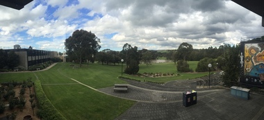
Photograph, Clare Gervasoni, Federation University Gippsland Campus, 2017, 03/10/2017
Federation University Australia was established on 1 January 2014. Formerly known as the University of Ballarat, its enabling legislation was the University of Ballarat Amendment (Federation University Australia) Act 2013. On 1 January 2014, the University of Ballarat amalgamated with the Monash University Gippsland Campus to form Federation University Australia. The Gippsland Campus also had a long lineage dating back to 1928 with the establishment of the Yallourn Technical School which became a predecessor institution to the Gippsland College of Advanced Education formed in 1968. In 1990, it was renamed the Monash University College and in 1993 became the Gippsland Campus of Monash University. In 2016, Federation University Australia announced plans to take possession, over a two-year period, of Monash’s Berwick Campus in the south-east corridor of Melbourne. Federation University Australia, or FedUni, is headquartered in Ballarat and offers programs in Higher Education and Vocational Education and Training to regional Victoria and beyond. The University’s commitment to educational and social equity, teaching excellence, research distinction, environmental sustainability and regional capacity building has enabled it to develop in a way that draws on its proud heritage to inform its future. Its regional character sets a framework for the University’s priorities but does not constrain it from serving wider community interests, nationally and internationally. The name Federation University Australia was chosen to convey the scope and capacity of an expanded regional university with a federated network of campuses. Colour panoramic photorgraph of the Federation University Gippsland Campus.federation university, gippsland campus, churchill campus -
 Federation University Historical Collection
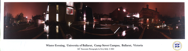
Photograph - Colour, 'University of Ballarat, Camp Street Campus, Ballarat Victoria' by Terry Kelly, 2002, 2002
Mounted colour photograph of a 360 degree panoramic view of the University of Ballarat Arts Academy (later Federation University). .1) Daylight .2) Nightterry kelly, arts academy, camp street, ballarat, alfred deakin place -
 Glenelg Shire Council Cultural Collection
Photograph - Photograph - Lee Breakwater, Portland, n.d
Port of Portland Authority ArchivesBack: PANORAMIC VIEW OF HARBOUR BASIN, PORTLAND - Pencil B 1966 - back penport of portland archives, tanker berth, k s anderson wharf, silos, marine, industry -
 City of Moorabbin Historical Society (Operating the Box Cottage Museum)
Photograph - B/W Bentleigh SS No.2083 1930, c1930
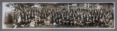
... A Photograph , black & white panoramic showing group... thomas A Photograph , black & white panoramic showing group ...The Common School No. 213 East Brighton 1864 - 1878 replaced the original St Stephen's Church of England School in Tucker Road. 1878-1908 the School was known as Education Department State School No. 2083 Brighton East. 1908 - 1936 the School changed it's name to Bentleigh and then from 1936 - 1993 was known as East Bentleigh. 1993 the school was closed due to low enrolments and the building was demolished and land sold. Eric Hutchinson, the uncle of Les Hutchinson attended this school. A school photograph of one of the original schools in the Bentleigh area showing a gathering of adults and children who had connection with this school either as teachers, pupils, parents or neighbours in 1930.A Photograph , black & white panoramic showing group of adults and children in front of Bentleigh State School No. 2083 c1930 (Reprint) moorabbin, bentleigh, education department state schools, st stephens anglican school east brighton, hutchinson les, hutchinson eric, market gardeners, early settlers, pioneers, henry dendyspecial survey brighton 1841, east bentleigh state school no. 2083, coates charles j, bent thomas -
 Bendigo Historical Society Inc.
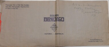
Book - GOLDEN BENDIGO
Golden Bendigo the Forest City, panoramic view of Pall Mall Bendigo and other photographic reproductions of views of the city. Printed and published by the Cambridge Press Bendigo Vic. Name on cover, Mr. A.S.Chambers Happy Valley Ravensthorpe WA Wide format booklet; paper with black and white panoramic photos of Bendigo.books, collections, photographs, bendigo -
Port Melbourne Historical & Preservation Society
Photograph - QEII arriving at Station Pier, Port Melbourne, 2001
Bought from "the Age" by donorColour photograph of QEII arriving at Station Pier. Tugs fore and aft pushing the ship to her berth. Panoramic view of Port Melbourne and city skyline. Copyright "The Age"transport - shipping, piers and wharves - station pier, rms queen elizabeth 2, qe2, beacon cove -
 Port Melbourne Historical & Preservation Society
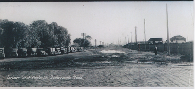
Photograph - Lorimer Street at Ingles Street, Fisherman's Bend, 1930s
Photographic copy of "Lorimer St at Ingles St, Fisherman's Bend" early 1930s. A panoramic photo with added title in white. On left are vehicles parked at the Sandridge Golf Club (formerly the Victoria Golf Club which moved to Cheltenham in 1927)On rear in ink : from "Ginger" Weedon. Formally (sic) from Dunstan Parade Garden City H/C Estatefishermans bend, sport, built environment - domestic, weedon, lorimer street -
Port Melbourne Historical & Preservation Society
Photograph - The Anchorage, Rouse Street frontage, Port Melbourne, Pat Grainger, c. 1993
Photographed around the neighbourhood in the early 1990s.One of three panoramic colour photos taken in the 1990s 1990s view of Rouse St frontage of "The Anchorage"(former Swallow & Ariell buildings) prior to street plantingbuilt environment - domestic, the anchorage -
Port Melbourne Historical & Preservation Society
Photograph - Former milkbar and bakery, corner Princes and Liardet Streets, Port Melbourne, Pat Grainger, c. 1993
Photographed around the neighbourhood in the early 1990s.One of three panoramic colour photos taken in the 1990s 1990s view of former milkbar and bakery at the corner of Princes and Liardet streets. Woman with trolley is Dawn ? from Station St.built environment - domestic, built environment - commercial, business and traders - milkbars, dawn (?) -
Port Melbourne Historical & Preservation Society
Photograph - Port Melbourne, Pat Grainger, 1996
Four panoramic black&white photos taken c1996 .01 View toward city of Nott Street and the school .02 View toward city of Nott Street, vertical .03 Pedestrian crossing in front of the 1910 post office .04 View north of Bay Street footpath, west sidebuilt environment, nott street, bay street -
Port Melbourne Historical & Preservation Society
Photograph - Beach Street, Port Melbourne, Alison Kelly, c. 1990
One of four photographs of Beach Street from Station to Princes Pier taken by Alison Kelly from the roof of the Missions to Seamen building. The four make up a panoramic view of the foreshore, .04 being an outer sectiondemolitions, piers and wharves - station pier, alison kelly -
Port Melbourne Historical & Preservation Society
Photograph - Beach Street, Port Melbourne, Alison Kelly, c. 1990
One of four photographs of Beach Street from Station to Princes Pier taken by Alison Kelly from the roof of the Missions to Seamen building. The four make up a panoramic view of the foreshore, .05 being an inner sectionpiers and wharves - princes pier, alison kelly -
Port Melbourne Historical & Preservation Society
Photograph - Beach Street, Port Melbourne, Alison Kelly, c. 1990
One of four photographs of Beach Street from Station to Princes Pier taken by Alison Kelly from the roof of the Missions to Seamen building. The four make up a panoramic view of the foreshore, .06 being an inner sectionpiers and wharves - station pier, alison kelly -
Port Melbourne Historical & Preservation Society
Photograph - Beach Street, Port Melbourne, Alison Kelly, c. 1990
One of four photographs of Beach Street from Station to Princes Pier taken by Alison Kelly from the roof of the Missions to Seamen building. The four make up a panoramic view of the foreshore, .07 being an outer section of the panoramapiers and wharves - princes pier, alison kelly -
Port Melbourne Historical & Preservation Society
Book, Richard Broome, Remembering Melbourne 1850-1960, 2016
"Remembering Melbourne 1850-1960". Large red covered book with black and white dust cover featuring panoramic view of Princes Bridge looking North. Photographs and text covering Melbourne CBD and 20 suburbs including Port Melbourne.Royal Historical Society Victoria (RHSV) bookplate signed by Don Garden and Richard Broome.built environment, business and traders, centenary bridge, piers and wharves - railway pier, sport, industry, religion - anglican (holy trinity), swallow & ariell ltd, sandridge lagoon, melbourne air service, joshua brothers distillery, robert harper & co ltd, faram brothers hardware, j kitchen & sons pty ltd, courthouse, police station, north port oval, missions to seamen, commonwealth engine works -
Port Melbourne Historical & Preservation Society
Photograph - Rooftop view over Stokes Street and the Anchorage apartments, Port Melbourne, Pat Grainger, May 2001
Taken while viewing the Town House being auctioned in Rouse Street cMay 2001From a series of colour photos taken at autumn auctions 2001, photo taken from the rooftop terrace of a town house formerly a part of the Swallow & Ariell offices at Rouse and Stokes: panoramic view over Stokes Street and the Anchorage:built environment, swallow & ariell ltd, the anchorage -
Port Melbourne Historical & Preservation Society
Photograph - Rooftop view over the Anchorage apartments, Port Melbourne, Pat Grainger, May 2001
Taken while viewing the Town House being auctioned in Rouse Street cMay 2001From a series of colour photos taken at autumn auctions 2001, photo taken from the rooftop terrace of a town house formerly a part of the Swallow & Ariell offices at Rouse and Stokes: panoramic view over the Anchorage:built environment, swallow & ariell ltd, the anchorage -
Port Melbourne Historical & Preservation Society
Photograph - Rooftop view towards the city from corner Rouse and Stokes Streets, Port Melbourne, Pat Grainger, May 2001
Taken while viewing the Town House being auctioned in Rouse Street cMay 2001From a series of colour photos taken at autumn auctions 2001, photo taken from the rooftop terrace of a town house formerly a part of the Swallow & Ariell offices at Rouse and Stokes: panoramic view toward the citybuilt environment, religion - roman catholic church (st josephs), swallow & ariell ltd -
Port Melbourne Historical & Preservation Society
Photograph - Auction, 53 Swallow Street, Port Melbourne, Pat Grainger, May 2001
From a series of colour photos taken at autumn auction 2001, 53 Swallow Street, May 2001 - home of Jo and Jim HILLIS, sold for $962,500: panoramic view of crowd watching Frank CALLAGHAN conduct auctionbuilt environment - domestic, jim hillis, joanne hillis, frank callaghan -
Port Melbourne Historical & Preservation Society
Photograph - St Joseph's Primary School, Stokes Street, Port Melbourne, 1996
Photographed by Pat Grainger after PMH&PS had moved out of the schoolFrom a group of three panoramic colour photos taken c1996: Stokes Street at frontage of former St Joseph's Primary School building 100 Stokes Streetbuilt environment, education - primary schools, st josephs catholic primary school -
Port Melbourne Historical & Preservation Society
Photograph - Graffiti under Graham Street overpass, Port Melbourne, 1996
Photographed by Pat Grainger; graffiti was cleaned or painted off later, and planter boxes in foreground removedFrom a group of three panoramic colour photos taken c1996: Graffiti under the Graham Street overpass "The cowboy is always watching"built environment, arts and entertainment - visual arts, crimes and misdemeanours, graffiti -
Port Melbourne Historical & Preservation Society
Photograph - Former New Great Britain Hotel, Stokes Street, Port Melbourne, 1996
the former hotel is now a private homeFrom a group of three panoramic colour photos taken c1996: former New Great Britain Hotel at 199 Stokes Street, workmen preparing surface prior to painting it off-white. Portion of 201 Stokes at right.built environment - domestic, hotels, new great britain hotel, built environment - commercial, stokes street -
Port Melbourne Historical & Preservation Society
Photograph - Former Port Theatre painted black, Bay Street, Port Melbourne, Pat Grainger, 1993
Record shots were taken over a three year period; this records the building as it had been for a number of years, rounded upper windows blocked in, bulding painted black. Also shows almond trees at left just prior to their removal by Council.Black and white photo of former Port Theatre, painted black - winter 1993 From set of five panoramic photos showing stages of development, former Port Theatre - restored in 1996 as shops and officesbuilt environment - commercial, port theatre -
Port Melbourne Historical & Preservation Society
Photograph - Former Port Theatre stripped to original brick, Bay Street, Port Melbourne, Pat Grainger, 1996
Record shots were taken over a three year period; stage in renovations by owner Despinis Kapogiannis and tenant Ian WilsonColour photo of former Port Theatre 1996, stripped to original brick. Bricked-in front windows visible, new square windows being installed. From set of five panoramic photos showing stages of development, former Port Theatre - restored in 1996 as shops and officesbuilt environment - commercial, port theatre -
Port Melbourne Historical & Preservation Society
Photograph - Former Port Theatre partially rendered, Bay Street, Port Melbourne, 1996
Record shots were taken over a three year period; stage in renovations by owner Despinis Kapogiannis and tenant Ian WilsonColour photo of former Port Theatre 1996: northern side partially rendered. From set of five panoramic photos showing stages of development, former Port Theatre - restored in 1996 as shops and officesbuilt environment - commercial, port theatre -
Port Melbourne Historical & Preservation Society
Photograph - Former Port Theatre centre window restored, Bay Street, Port Melbourne, David Thompson, Oct 1996
Record shots were taken over a three year period; stage in renovations by owner Despinis Kapogiannis and tenant Ian WilsonColour photo of former Port Theatre October 1996: Original centre window restored. From set of five panoramic photos showing stages of development, former Port Theatre - restored in 1996 as shops and officesbuilt environment - commercial, port theatre -
Port Melbourne Historical & Preservation Society
Photograph - Former Port Theatre centre window restored, Bay Street, Port Melbourne, David Thompson, Oct 1996
Record shots were taken over a three year period; stage in renovations by owner Despinis Kapogiannis and tenant Ian WilsonB&W photo of former Port Theatre October 1996: Original centre window restored. From set of five panoramic photos showing stages of development, former Port Theatre - restored in 1996 as shops and offices. This picture is 1993 from Liardet st across Bay st and the building is still unrenderedbuilt environment - commercial -
Port Melbourne Historical & Preservation Society
Photograph - PMHPS Christmas stall at Gasworks Arts and Crafts market, 30 Dec 1996
Record shot of PMH&PS stall selling the 1997 'Historic Port Calendar', photos by David Thompson and the usual items.Panoramic colour photo of Society's Christmas stall at Gasworks Arts and Crafts market 8 Dec. 1996. Left to right: David THOMPSON, Lois DALEY CATON, Ron STRANKSlois daley, david thompson, societies clubs unions and other organisations, ron stranks, celebrations fetes and exhibitions -
Port Melbourne Historical & Preservation Society
Photograph - Group with Port Melbourne Community Bus on Calder Highway, Pat Grainger, Aug 1993
... Photograph black and white panoramic of group with Port... julie allen Photograph black and white panoramic of group ...This group took the free community bus to Bendigo to see daffodils at Kyneton and woollen mills at Bendigo. Photographed at apple market along the highway by Pat Grainger. PMHPS members: Liana Thompson (3 from left; Wendy Morris (4 from left); Julie Allen (far right)Photograph black and white panoramic of group with Port Melbourne Community Bus on Calder Hwy August 1993transport - bus, kath morris, val salter (?), liana thompson, mayors, wendy morris - city librarian, beatrice (betty) goddard, julie allen