Showing 2288 items matching "parishes"
-
 Bendigo Historical Society Inc.
Map - MUSKERRY, No date visible
Map: Parish of Muskerry. Parish plan (number 310 in map cupboard 1)map, parish plan, muskerry -
 Whitehorse Historical Society Inc.
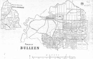
map, Parish of Bulleen, Not dated
A map on the parish of Bulleen.Parish of Bulleen with North East portion of the Parish of Nunawading [n.d. 1890's?]A map on the parish of Bulleen.shire of bulleen, shire of nunawading, land settlement -
Whitehorse Historical Society Inc.
Document, Certificate of Title, 1921, 1933
Certificate of Title, Charles Norris and William Richard Norris.Certificate of Title, Charles Norris and William Richard Norris. Lot 6 Subdivision 4894, part of crown portions 89 & 90, Parish of Nunawading, County of Bourke 1922. Vol 4474, fol 894734 also correspondence re rates, enforcement of charge 1933.Certificate of Title, Charles Norris and William Richard Norris.land titles, shire of blackburn and mitcham, norris, charles, norris, william richard, blackburn road, blackburn -
 Bendigo Historical Society Inc.
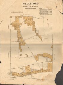
Map - JACK FLYNN COLLECTION: WELLSFORD, 15/12/1941
Map: Parish of Wellsford, County of Bendigo. Parish plan. 2 copies of the same plan.map, bendigo, parish plan, wellsford -
 Bendigo Historical Society Inc.
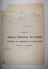
Map - BENDIGO IRRIGATION SETTLEMENT, 20/10/1908
Map: Bendigo Irrigation Settlement, Parishes of Sandhurst and Wellsford, County of Bendigo, Parish planmap, bendigo, irrigation settlement, bendigo irrigation settlement -
 Bendigo Historical Society Inc.
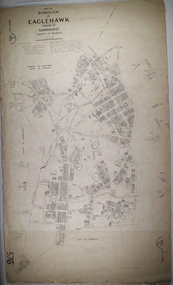
Map - BOROUGH OF EAGLEHAWK SHEET 1, 9/12/1902
Map: Borough of Eaglehawk, sheet No. 1, Parish of Sandhurst, County of Bendigo. Parish planmap, bendigo, parish plan, borough of eaglehawk -
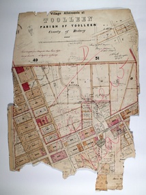 Bendigo Historical Society Inc.
Map - TOOLLEEN ALLOTMENTS, circa 1870
Map: Parish plan showing Village allotments at Toolleen, Parish of Toolleen, County of Rodneymap, rodney, toolleen, parish of toolleen, county of rodney -
 Bendigo Historical Society Inc.
Map - JACK FLYNN COLLECTION: GIRGARRE, 14/10/1943
Map: Parish of Girgarre , County of Rodney. Parish plan. Same map as 10100.20 but in poorer condition.By Authority, H.E.Daw, Government printer Melbourne. Drawn and Reproduced at the Dept, of Lands and Survey, Melbourne, Victoriamap, rodney, girgarre, girgarre, county of rodney -
 Bendigo Historical Society Inc.
Map - JACK FLYNN COLLECTION: ARCHDALE, 15/01/1936
Map: Parish of Archdale, County of Gladstone. Parish plan. The Allotments have been coloured in with pencil.By Authority H.J. Green, Government Printer Melbourne. Drawn and Reproduced at the Dept, of Lands and Survey, Melbourne, Victoria. 15/01/36map, gladstone, parish plan, archdale , gladstone -
Bendigo Historical Society Inc.
Map - PARISH OF LAANECOORIE, 13/10/1930
Map: Parish of Laanecoorie, County of Bendigo. Parish plan ( number 176 in Map Cupboard 1)map, bendigo, parish plan, laanecoorie -
Bendigo Historical Society Inc.
Map - BOROUGH OF EAGLEHAWK SHEET 1A, 30/11/1931
Map: Borough of Eaglehawk, Parish of Nerring. Parish plan ( number 186 in Map Cupboard 1)map, bendigo, parish plan, borough of eaglehawk, parish of nerring -
Bendigo Historical Society Inc.
Map - PARISH OF DIGGORRA, 23/02/1911
Map: Parish of Diggorra, County of Bendigo. Parish plan ( number 247 in Map Cupboard 1)map, bendigo, parish plan, diggorra -
Bendigo Historical Society Inc.
Map - PARISH OF WHIRRAKEE, Surveyed 14/07/1904
Map: Parish of Whirrakee. Hand Draughted Parish plan (number 280 in map cupboard 1)map, bendigo, parish plan, whirrakee -
Bendigo Historical Society Inc.
Map - NOLAN, 11/04/1889
Map: Parish of Nolan, County of Bendigo. Parish plan (number 346 in map cupboard 1)map, bendigo, parish plan, nolan -
Bendigo Historical Society Inc.
Map - GOORNONG, 21/08/1888
Map: Parish of Goornong, County of Bendigo. Parish plan (number 345 in map cupboard 1)map, bendigo, parish plan, goornong -
Bendigo Historical Society Inc.
Map - ELMORE, 2/03/1880
Map: Parish of Elmore, County of Bendigo. Parish plan. (number 344 in map cupboard 1)map, bendigo, parish plan, elmore -
Bendigo Historical Society Inc.
Map - EGERTON, 22/03/1892
Map: Parish of Egerton, County of Bendigo. Parish plan (number 343 in map cupboard 1)map, bendigo, parish plan, egerton -
Bendigo Historical Society Inc.
Map - DIGGORA, 7/03/1892
Map: Parish of Diggora, County of Bendigo. Parish plan (number 341 in map cupboard 1)map, bendigo, parish plan, diggora -
Bendigo Historical Society Inc.
Map - KIMBOLTON, 20/12/1907
Map: Parish of Kimbolton, County of Bendigo. Parish plan. (number 339 in map cupboard 1)map, bendigo, parish plan, kimbolton -
Bendigo Historical Society Inc.
Map - EPPALOCK, 3/07/1890
Map: Parish of Eppalock. County of Bendigo. Parish plan (number 338 in map cupboard 1)map, bendigo, parish plan, eppalock -
Bendigo Historical Society Inc.
Map - LYELL, 24/09/1907
Map: Parish of Lyell, County of Bendigo. Parish plan (number 337 in map cupboard 1)map, bendigo, parish plan, lyell -
Bendigo Historical Society Inc.
Map - EGERTON, 28/01/1896
Map: Parish of Egerton, County of Bendigo. Parish plan. (number 335 in map cupboard 1)map, bendigo, parish plan, egerton -
Bendigo Historical Society Inc.
Map - BALLENDELLA, 12/06/1882
Map: Parish of Ballendella, County of Bendigo. Parish plan (number 333 in map cupboard 1)map, bendigo, parish plan, ballendella -
Bendigo Historical Society Inc.
Map - MARONG, 16/08/1881
Map: Parish of Marong, County of Bendigo. Parish plan (number 328 in map cupboard 1)map, bendigo, parish plan, marong -
Bendigo Historical Society Inc.
Map - EPPALOCK, 3/11/1882
Map: Parish of Eppalock, County of Bendigo. Parish plan (number 327 in map cupboard 1)map, bendigo, parish plan, eppalock -
Bendigo Historical Society Inc.
Map - DARGILE, 14/10/1906
Map: Parish of Dargile, County of Rodney. Parish plan (number 324 in map cupboard 1)map, rodney, parish plan, dargile -
Bendigo Historical Society Inc.
Map - WELLSFORD, 15/10/1903
Map: Parish of Wellsford, County of Bendigo. Parish plan (number 321 in map cupboard 1)map, bendigo, parish plan, wellsford -
Bendigo Historical Society Inc.
Map - HEATHCOTE, 11/04/1935
Map: Parish of Heathcote, County of Dalhousie. Parish plan (number 320 in map cupboard 1)map, dalhousie, parish plan, heathcote -
Bendigo Historical Society Inc.
Map - TALAMBE, 26/11/1880
Map: Parish of Talambe, County of Bendigo. Parish plan (number 315 in map cupboard 1)map, bendigo, parish plan, talambe -
Bendigo Historical Society Inc.
Map - PANNOOBAMAWM, 6/11/1882
Map: Parish of Pannoobamawm, County of Bendigo, Parish plan (number 314 in map cupboard 1)map, bendigo, parish plan, pannoobamawm