Showing 840 items
matching plan of subdivision
-
 Bendigo Historical Society Inc.
Map - KANGAROO FLAT SUBDIVISION, 26/11/1900
... Map: Plan of Subdivision at Kangaroo flat, Parish... of Bendigo Map: Plan of Subdivision at Kangaroo flat, Parish ...Map: Plan of Subdivision at Kangaroo flat, Parish of Sandhurst, County of Bendigo ( number 149 in Map Cupboard 1)map, bendigo, parish plan, kangaroo flat, parish of sandhurst, county of bendigo -
 Whitehorse Historical Society Inc.
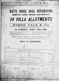
Document, Hampton Court Estate
... Plan of subdivision Hampton Court Estate Whitehorse Road... of subdivision Hampton Court Estate Plan of subdivision Hampton Court ...Plan of subdivision Hampton Court EstatePlan of subdivision Hampton Court Estate Whitehorse Road, Nunawading 1882. Original in Vale Maps LaTrobe LibraryPlan of subdivision Hampton Court Estate hampton court estate, byrne vale & co. -
 Whitehorse Historical Society Inc.
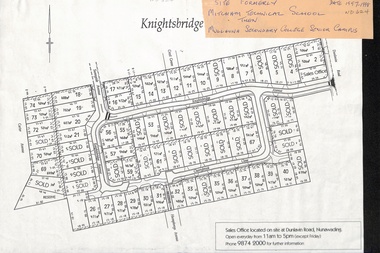
Map, Knightsbridge Estate, Nunawading, Ca 1997 - 1998
... Plan of subdivision of former Mitcham Technical School... Plan of subdivision of former Mitcham Technical School ...Plan of subdivision of former Mitcham Technical School and later Mullauna Secondary College Senior Campus - Knightsbridge Estate.land subdivision, knightsbridge estate, mitcham technical school, mullauna secondary college, senior campus, cherrybrook close, nunawading, knightsbridge avenue, sunnyside avenue, crest grove, dunlavin road, mitcham, carter avenue, humphreys avenue -
Ringwood and District Historical Society
Legal record - Conditions of Sale (C.E.Carter), Mitcham - Crown Allotment 124. M.E.Burke to ? Dated June 1st 1929
... and 45 on Plan of Subdivision 6736, Mitcham Road, Mitcham. Mrs... of Sale of Property , Lot 44 and 45 on Plan of Subdivision 6736 ...Particulars and Conditions of Sale of Property , Lot 44 and 45 on Plan of Subdivision 6736, Mitcham Road, Mitcham. Mrs M.E.Burke to ? -
Federation University Historical Collection
Plan, Plan of Mount Helen, 7/7/1964
... Plan of Subdivisions to Mount Helen, Shire of Buninyong... clear road Plan of Subdivisions to Mount Helen, Shire ...Plan of Subdivisions to Mount Helen, Shire of Buninyong, Sheet 1 and Sheet 2 Scale 200 feet to one inchmidland highway, gear avenue, eddy avenue, shire avenue, boak avenue, moss avenue, rathkeale avenue, ingliston avenue, chatham avenue, mardango drive, nyora grove, yarana drive, shakespeare avenue, marina avenue, landale avenue, lylia avenue, recreation road, olympic avenue, the gums, heather avenue, dallas avenue, jones avenue, sebastopol mount clear road -
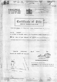
Whitehorse Historical Society Inc.
Legal record - Document, Certificate of Title, 28/10/1913 12:00:00 AM
... Certificate of Title for Lot 41, Plan of Subdivision... of Victoria Certificate of Title for Lot 41, Plan of Subdivision ...Certificate of Title for Lot 41, Plan of Subdivision no. 2525, Deakin Street Mitcham, owned by State Savings Bank of Victoria.Certificate of Title for Lot 41, Plan of Subdivision no. 2525, Deakin Street Mitcham, owned by State Savings Bank of Victoria.Certificate of Title for Lot 41, Plan of Subdivision no. 2525, Deakin Street Mitcham, owned by State Savings Bank of Victoria.deakin street mitcham, state savings bank of victoria -
Whitehorse Historical Society Inc.
Legal record - Land Title, Certificate of Title, 1974 - 1998
... Certificate of Title: Vol 09048, Fol 467 Lot 1, Plan... of Title: Vol 09048, Fol 467 Lot 1, Plan of Subdivision 113045, 64 ...Certificate of Title: Vol 09048, Fol 467 Lot 1, Plan of Subdivision 113045, 64 Quarry Street, MitchamCertificate of Title: Vol 09048, Fol 467 Lot 1, Plan of Subdivision 113045, 64 Quarry Street, MitchamCertificate of Title: Vol 09048, Fol 467 Lot 1, Plan of Subdivision 113045, 64 Quarry Street, Mitchamquarry road, mitcham, no 64, land titles, mcclare, john, the glade, robertson, susan jayne, peter-budge -
Whitehorse Historical Society Inc.
Document, Title to 59 Mount Pleasant Road Nunawading, 1871 - 1992
... Copies of Title documents for Lot 3, Plan of Subdivision..., Plan of Subdivision 18705 for Section 117b, Parish ...Copies of Title documents for Lot 3, Plan of Subdivision 18705 for Section 117b, Parish of Nunawading from 1871 to 1992.Copies of Title documents for Lot 3, Plan of Subdivision 18705 for Section 117b, Parish of Nunawading from 1871 to 1992.Copies of Title documents for Lot 3, Plan of Subdivision 18705 for Section 117b, Parish of Nunawading from 1871 to 1992.mount pleasant road, nunawading no. 59, land titles, jones, dan, jones, anne -
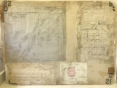
Glenelg Shire Council Cultural Collection
Administrative record - Plans, n.d
... Black and white photocopy of old plan of subdivision, same... of old plan of subdivision, same as 8398, 8399, smaller scale ...Black and white photocopy of old plan of subdivision, same as 8398, 8399, smaller scale, numerous notations, added by Vanda Savill. -
Whitehorse Historical Society Inc.
Legal record - Land Title, Blackburn
... Plan of subdivision of part of Crown Portions 81,92 and 89... central road gordon crescent wolseley crescent Plan of subdivision ...Plan of subdivision of part of Crown Portions 81,92 and 89, Parish of Nunawading, County of Bourke. Photograph produced 11 Aug 1947.Plan of subdivision of part of Crown Portions 81,92 and 89, Parish of Nunawading, County of Bourke. Photograph produced 11 Aug 1947.Plan of subdivision of part of Crown Portions 81,92 and 89, Parish of Nunawading, County of Bourke. Photograph produced 11 Aug 1947.blackburn road, blackburn, wellington avenue, central road, gordon crescent, wolseley crescent -
 Whitehorse Historical Society Inc.
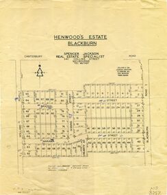
Map, Henwoods Estate, Blackburn
... Plan of subdivision in Blackburn South between Holland Road... street hearty street Plan of subdivision in Blackburn South Plan ...Plan of subdivision in Blackburn SouthPlan of subdivision in Blackburn South between Holland Road and Blackburn Road. Estate advertised by Spencer Jackson, 341 Collins Street.Plan of subdivision in Blackburn South land subdivision, henwoods estate, blackburn south, holland road, brazeel street, marama street, blackburn road, gissing street, hearty street -
Whitehorse Historical Society Inc.
Map, Burwood Road, Box Hill City, 15/02/1952 12:00:00 AM
... Plan of subdivision of ten blocks in Burwood Road, Burwood.... Marked as Survey Plan No 5441. Land Subdivision Burwood Road ...Plan of subdivision of ten blocks in Burwood Road, Burwood.Plan of subdivision of ten blocks in Burwood Road, Burwood between Milford Avenue and Station Street. Marked as Survey Plan No 5441.Plan of subdivision of ten blocks in Burwood Road, Burwood. land subdivision, burwood road, burwood, milford avenue, burwood, central court, burwood -
Whitehorse Historical Society Inc.
Map, Burwood Road, Box Hill City, 15/02/1952 12:00:00 AM
... Plan of subdivision of 19 blocks in Burwood Road, Burwood.... Marked as Survey Plan No 5442. Land Subdivision Burwood Road ...Plan of subdivision of 19 blocks in Burwood Road, Burwood.Plan of subdivision of 19 blocks in Burwood Road, Burwood between Greenwood Street and Middleborough Road. Marked as Survey Plan No 5442.Plan of subdivision of 19 blocks in Burwood Road, Burwood. land subdivision, burwood road, burwood, greenwood street, burwood, middleborough road, burwood -
 Kew Historical Society Inc
Plan - Subdivision Plan, Houghton Street & Buchanan Avenue, Balwyn North, ca. 1906
... Subdivision Plan... subdivision plans pertaining to suburbs of the City of Melbourne. Most...A hand-drawn subdivision plan listing six blocks bounded... subdivision plans pertaining to suburbs of the City of Melbourne. Most ...The Kew Historical Society collection includes almost 100 subdivision plans pertaining to suburbs of the City of Melbourne. Most of these are of Kew, Kew East or Studley Park, although a smaller number are plans of Camberwell, Deepdene, Balwyn and Hawthorn. It is believed that the majority of the plans were gifted to the Society by persons connected with the real estate firm - J. R. Mathers and McMillan, 136 Cotham Road, Kew. The Plans in the collection are rarely in pristine form, being working plans on which the agent would write notes and record lots sold and the prices of these. The subdivision plans are historically significant examples of the growth of urban Melbourne from the beginning of the 20th Century up until the 1980s. A number of the plans are double-sided and often include a photograph on the reverse. A number of the latter are by noted photographers such as J.E. Barnes.A hand-drawn subdivision plan listing six blocks bounded by Houghton Street, Doncaster Road, Buchanan Avenue and Maud Street, North Balwyn. Written on the plan of subdivision are the lot numbers, the dimensions of the blocks and the price at which two lots were for sale or had been sold for.subdivision plans - balwyn -
Whitehorse Historical Society Inc.
Document, Certificate of Title, 21/07/1920 12:00:00 AM
... and 79, Plan of Subdivision no. 3212, Blackburn, owned by Thomas... Certificate of Title vol.4351 fol. 870161 for Lots 19 and 79, Plan ...Certificate of Title vol.4351 fol. 870161 for Lots 19 and 79, Plan of Subdivision no. 3212, Blackburn, owned by Thomas James HamiltonCertificate of Title vol.4351 fol. 870161 for Lots 19 and 79, Plan of Subdivision no. 3212, Blackburn, owned by Thomas James HamiltonCertificate of Title vol.4351 fol. 870161 for Lots 19 and 79, Plan of Subdivision no. 3212, Blackburn, owned by Thomas James Hamiltonhamilton, thomas james, station street blackburn -
Whitehorse Historical Society Inc.
Map, Mason's Paddock, Blackburn, 1919
... Mason's Paddock, Blackburn, plan of subdivision, 17 lots.... Mason's Paddock, Blackburn, plan of subdivision, 17 lots ...Mason's Paddock, Blackburn, plan of subdivision, 17 lots, realising auction, Saturday Nov 29, 1919.Mason's Paddock, Blackburn, plan of subdivision, 17 lots, realising auction, Saturday Nov 29, 1919. Agents T.R.B. Morton & Son.Mason's Paddock, Blackburn, plan of subdivision, 17 lots, realising auction, Saturday Nov 29, 1919. t.r.b. morton & son, blackburn, masons paddock, blackburn road, blackburn, masons road, blackburn, canterbury road, blackburn -
 Warrnambool and District Historical Society Inc.
Subdivision plan, Part of Preston Estate Parish of Wappan
... Subdivision plan...Plan of subdivision of part of crown allotments 15 and 17... in pink. Part of Preston Estate Parish of Wappan. Subdivision plan ...This map possibly relates to land of John Bostock at Preston, Delatite. Part of a collection of papers relating to the Bostock family one of the earliest pioneering families in Warrnambool.Cream coloured map printed in black with sections coloured in pink. Plan of subdivision of part of crown allotments 15 and 17 and part of Preston pre- emptive right, Parish of Wappan, County of Delatite.warrnambool,bostock,augustus bostock map, delatite map,district of wappan map, -
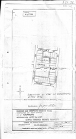 Whitehorse Historical Society Inc.
Document, Subdivision of part of W.B. Wickings Estate, 1952
... Plan of subdivision of part of W.B. Wickings Estate, 1952... benjamin Later subdivision Wicking Court. Plan of subdivision ...Plan of subdivision of part of W.B. Wickings Estate, 1952. Reticulation area 1457, Sewer through private property. Melbourne and Metropolitan Board of Works document.land subdivision, holland road, blackburn south, constance street, gissing street, rosen street, wicking court, melbourne and metropolitan board of works, sewerage and sanitation, wicking, walter benjamin -
Whitehorse Historical Society Inc.
Map, Parish of Nunawading, 1939
... Plan of subdivision part of crown portions 81, 82 and 89... of subdivision part of crown portions 81, 82 and 89, Plan of subdivision ...Plan of subdivision part of crown portions 81, 82 and 89,Plan of subdivision part of crown portions 81, 82 and 89, Parish of Nunawading, County of Bourke, Blackburn Wellington Avenue amended from Stanley RoadPlan of subdivision part of crown portions 81, 82 and 89, street names, parish of nunawading, blackburn road, blackburn, wellington avenue, blackburn, wolseley crescent, blackburn, gordon crescent, blackburn, clarke street, blackburn, central road, blackburn -
 Whitehorse Historical Society Inc.
Legal record - Document, Edgerton Road, 28/10/1958
... on Plan of Subdivision No 44073 (No 11) Edgerton Road, Mitcham... of Title Vol 8213, Fol 643 (Photocopy) Lot 10 on Plan ...Certificate of Title Vol 8213, Fol 643 (Photocopy) Lot 10 on Plan of Subdivision No 44073 (No 11) Edgerton Road, Mitcham. Transactions 1958 - 1988.edgerton road, mitcham, no 11, land titles, simpson, graham royal, biczok, iosif, dunne, rosemary geraldine -
Whitehorse Historical Society Inc.
Legal record - Land Title, Certificate of Title, 1919
... Lots 21 and 22 on Plan of Subdivision no. 6149 Crown... and 22 on Plan of Subdivision no. 6149 Crown Portion 89, Parish ...Lots 21 and 22 on Plan of Subdivision no. 6149 Crown Portion 89, Parish of Nunawading vol. 4192 fol. 838287, owned by State Savings Bank of VictoriaLots 21 and 22 on Plan of Subdivision no. 6149 Crown Portion 89, Parish of Nunawading vol. 4192 fol. 838287, owned by State Savings Bank of VictoriaLots 21 and 22 on Plan of Subdivision no. 6149 Crown Portion 89, Parish of Nunawading vol. 4192 fol. 838287, owned by State Savings Bank of Victoriablackburn road blackburn, walsham road blackburn, state savings bank of victoria -
Tatura Irrigation & Wartime Camps Museum
Poster, Tatura Subdivision, 1928
... Large Tatura subdivision poster of 1928 advertising large... Tatura was founded. tatura subdivision hogans estate Great ...Hogans Estate was privately owned land on Tatura's north side as opposed tot he government sub division when Tatura was founded.Large Tatura subdivision poster of 1928 advertising large area north of Hogan Street, named Hogan Estate. Clear plan of subdivisions. Bold print in red and blue.Great subdivision sale. Hogans Estate Tatura. Saturday 18 August 1928. J. McNamara & Co.tatura subdivision, hogans estate -
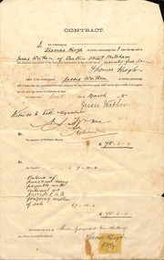 Whitehorse Historical Society Inc.
Document, Mitcham, 1/03/1915
... , Parish of Nunawading, County of Bourke being Lot 6 on plan... of Nunawading, County of Bourke being Lot 6 on plan of subdivision ...Contract of sale of part Crown Portion 119,05 Mitcham, Parish of Nunawading, County of Bourke being Lot 6 on plan of subdivision No. 5339, by Thomas Keogh to Jessie Wathenland sales, wathen, jessie, keogh, thomas, mitcham -
Whitehorse Historical Society Inc.
Legal record - Document, Certificate of Title, 1977
... 13 Plan of Subdivision no. 4488, cnr. Creek Road and East... of Lot 13 Plan of Subdivision no. 4488, cnr. Creek Road and East ...Certificate of Title vol. 5564 fol. 1112691 for part of Lot 13 Plan of Subdivision no. 4488, cnr. Creek Road and East Road Mitcham, owned by George Albert SmithCertificate of Title vol. 5564 fol. 1112691 for part of Lot 13 Plan of Subdivision no. 4488, cnr. Creek Road and East Road Mitcham, owned by George Albert SmithCertificate of Title vol. 5564 fol. 1112691 for part of Lot 13 Plan of Subdivision no. 4488, cnr. Creek Road and East Road Mitcham, owned by George Albert Smithcreek road mitcham, smith, george albert, east road mitcham -
Whitehorse Historical Society Inc.
Legal record - Land Title, Deep Creek Road, Mitcham, 1936
... Certificate of Title vol 6087 Fol 1217316 Lot 133 of plan... Fol 1217316 Lot 133 of plan of subdivision no 8022 in the name ...Certificate of Title vol 6087 Fol 1217316 Lot 133 of plan of subdivision no 8022 in the name of Francisco Schwerkolt on 22 Dec 1936 including transactions until Oct 2000.Certificate of Title vol 6087 Fol 1217316 Lot 133 of plan of subdivision no 8022 in the name of Francisco Schwerkolt on 22 Dec 1936 including transactions until Oct 2000.Certificate of Title vol 6087 Fol 1217316 Lot 133 of plan of subdivision no 8022 in the name of Francisco Schwerkolt on 22 Dec 1936 including transactions until Oct 2000.schwerkolt, francisco, deep creek road, mitcham, no 27., rangeview grove, hogan, frances dora, collins, douglas alexander, oulton alice, vicic, susan manuella, hammond, wayne, alexander, hannelore -
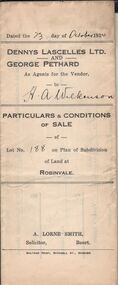 Bendigo Historical Society Inc.
Document - H.A. & S.R. WILKINSON COLLECTIONCONDITION OF SALE
... Particulars & conditions of sale of lot no. 188 on plan... & conditions of sale of lot no. 188 on plan of subdivision of land ...Particulars & conditions of sale of lot no. 188 on plan of subdivision of land at Robinvale between Dennys Lascelles Ltd + George Pethard as agents for the vendor and H. A. Wilkinson (buyer). Price 63 pounds.organization, business, h.a. & s.r wilkinson real estate -
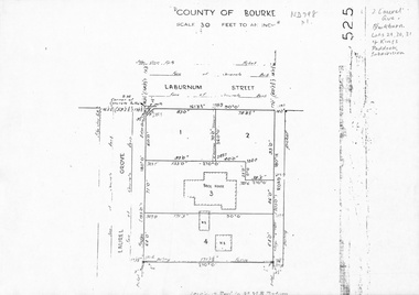 Whitehorse Historical Society Inc.
Map, Laurel Grove, 1959
... Plan of subdivision, part of Crown Portion 84, Lots 29, 30... subdivision kings paddock Plan of subdivision, part of Crown Portion ...Plan of subdivision, part of Crown Portion 84, Lots 29, 30, 31 Kings Paddock subdivision, cnr Laurel Grove and Laburnum Street, Blackburn. Ref 2713, 6/2/1959.laurel grove, blackburn, laburnum street, land subdivision, kings paddock -
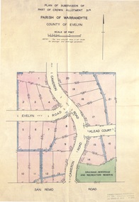 Ringwood and District Historical Society
Document - Real Estate Folder, Savernake Estate, Ringwood, Victoria - Stage one - 1967
... Plan of Subdivision, Part of Crown Allotment 31A...: 723 3298, 878 2648. Subdivision Plan stamped Donald Cameron..., 878 2648. Subdivision Plan stamped Donald Cameron Consultants ...Plan of Subdivision, Part of Crown Allotment 31A and advertisement for sale of residential allotments with map showing layout of subdivision. Typewritten pricelist attached outlining suggested terms of sale as of 14 September, 1967.Subdivision includes Evelyn Road, Cameron Road, Klead Court, and San Remo Road. Agent - C.E. Carter & Son., 126 Whitehorse Road, Ringwood. (Phone) 87-6024, 87-6830, 870-2519, After hours: 723 3298, 878 2648. Subdivision Plan stamped Donald Cameron Consultants Pty. Ltd., Consulting Engineers, 472 Bourke Street Melbourne - 67-2602. -
 Greensborough Historical Society
Planning document, City of Heidelberg, Subdivision Plan # G26. Grace Park Estate Greensborough, 1950c
... Subdivision Plan # G26. Grace Park Estate Greensborough....Plan of Subdivision (G26). Grace Park Estate. ... Plenty Lower Plenty melbourne Plan of Subdivision (G26). Grace ...Plan of Subdivision (G26). Grace Park Estate. An example of hard copy subdivision plans from the Greensborough area. From Shire of Heidelberg.Plan mounted on heavy card.Stamped and handwritten Council permissions, dates and other details.subdivision plans, grace park -
 Kew Historical Society Inc
Photograph - 8 roomed DF Brick Villa, Kew, J E Barnes, c.1920
... Subdivision plans are historically important documents used... of the photograph is a subdivision plan for the Normanby Estate, East Kew... Subdivision plans are historically important documents used ...Subdivision plans are historically important documents used as evidence of the growth of suburbs in Australia. They frequently provide information about when the land was sold on which a built structure was subsequently constructed as well as evidence relating to surveyors and real estate and financial agents. The numerous subdivision plans in the Kew Historical Society's collection represent working documents, ranging from the initial sketches made in planning a subdivision to printed plans on which auctioneers or agents listed the prices for which individual lots were sold. In a number of cases, the reverse of a subdivision plan in the collection includes a photograph of a house that was also for sale by the agent. These photographs provide significant heritage information relating house design and decoration, fencing and household gardens. The photograph is of additional aesthetic significance as it was photographed by J. E. Barnes. Josiah Earl Barnes is a nationally significant photographer. He was also the most important photographer to have worked in Kew. He was active as a photographer in the district from c.1906 until his death in 1921. Best known as 'the Embarkation Photographer' (see the Australian War Memorial collection), J. Earl Barnes was also the official photographer employed by the Borough (and later Town, then City) of Kew. He clearly also completed commercial jobs for local businesses, as is the case in this photograph of a house for a local real estate and financial agent.A photograph, mounted on board of a double fronted Federation-era brick villa in Kew, photographed for a local real estate agent and financier by J. E. Barnes of Kew. On the reverse of the photograph is a subdivision plan for the Normanby Estate, East Kew - 2016.0039.1. As can be seen from the image, there is a large tear on the surface of the photograph.The brown card on which the photograph is mounted includes the following handwritten description, which may aid the identification of the house: "Kew, 3 minutes from tram, 8 roomed DF Brick Villa, tile roof including two attics, sleepout, bathroom, heater, E Light, Entrance Hall, double doors, leadlights, laundry, garden, lawns, land 75 x 170, 1975 pounds". Also photographers inscription on mount, lower left: J. E. Barnes / Photo / Phone 1966 Haw. KEW.j. e. barnes, josiah earl barnes, j. earl banes - photographer, architecture - federation style, houses - kew, real estate photographs