Showing 1148 items matching "price collection"
-
 Bendigo Historical Society Inc.
Document - H.A. & S.R. WILKINSON COLLECTION: CONTRACT OF SALE
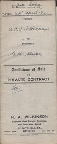
Conditions of sale by private contract dated 24th April, 1941 between A.B.P. Pattison (seller) and G.H. Sharpe (buyer) for land situate No. 19 Hayes Street, Bendigo, being land described in right to occupy residence area No. 7157, together with 6-roomed weatherboard and brick dwelling and all sundry. Price 190 pounds. Attached receipt signed by Mr. Pattison acknowledging payment.organization, business, h.a. & s.r wilkinson real estate -
 Bendigo Historical Society Inc.
Document - H.A & S.R. WILKINSON COLLECTION: CONTRACT OF SALE
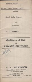
Conditions of sale by private contract dated 11th June, 1941 between Mr. A.C. Beaton (seller) and P.J. Stewart (buyer) for land situate Hill Street Kangaroo Flat, together with 5-roomed weatherboard dwelling and all sundry. Also all electric light fittings and window blinds. Price 320 pounds.organization, business, h.a. & s.r wilkinson real estate -
 Bendigo Historical Society Inc.
Document - H.A. & S.R. WILKINSON COLLECTION: CONTRACT OF SALE
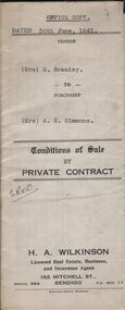
Conditions of sale by private contract dated 30th June, 1941 between Mrs. S. Bramley (seller) and Mrs. A.E. Simmons (buyer) for land situate Dillon Street, Long Gully, at present unoccupied being Crown allotment 497 section K described in certificate of title volume 3999 folio 799707. Also all the vendor's right title and interest in and to all that piece of land adjoining the above being land described in right to occupy residence area right No. 387, together with 5-roomed weatherboard dwelling and all sundry. Price 250 pounds.organization, business, h.a. & s.r wilkinson real estate -
 Bendigo Historical Society Inc.
Document - H.A. & S.R. WILKINSON COLLECTION: CONTRACT OF SALE
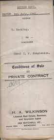
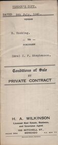
Conditions of sale by private contract dated 5th July, 1941 between B. Hocking (seller) and Mrs. I.F. Stephenson (buyer) for land situate 25 Reginald Street, Bendigo being Crown allotment 7 section 104C land described in certificate of title volume 2684 folio 536778, together with 5-roomed weatherboard dwelling and all sundry. Also all electric globes and shades, all wire doors and screens and ''Main'' gas stove connected in place of present gas stove. Price 400 pounds. This is the office copy, attached: copy of insurance policy and city of Bendigo rates notice and receipts of paymentsorganization, business, h.a. & s.r wilkinson real estate -
 Bendigo Historical Society Inc.
Document - H.A. & S.R. WILKINSON COLLECTION: CONTRACT OF SALE
Conditions of sale by private contract dated 5th July, 1941 between B. Hocking (seller) and Mrs. I.F. Stephenson (buyer) for land situate 25 Reginald Street, Bendigo being Crown allotment 7 section 104C land described in certificate of title volume 2684 folio 536778, together with 5-roomed weatherboard dwelling and all sundry. Also all electric globes and shades, all wire doors and screens and ''Main'' gas stove connected in place of present gas stove. Price 400 pounds.organization, business, h.a. & s.r wilkinson real estate -
 Bendigo Historical Society Inc.
Document - H.A. & S.R. WILKINSON COLLECTION: CONDITIONS OF SALE
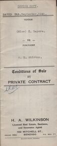
Conditions of sale by private contract dated 5th September, 1941 between Miss H. Sayers (seller) and A.E. Stirton (buyer) for land situate corner Violet and Pitt Streets, Bendigo, at present occupied by tenants, being Crown allotment 9A section 60 B land described in Crown grant volume 955 folio 190078, together with all buildings and erections on the said land. Subject to existing weekly tenancy. Price 200 pounds.organization, business, h.a. & s.r wilkinson real estate -
 Bendigo Historical Society Inc.
Document - H.A. & S.R. WILKINSON COLLECTION: CONTRACT OF SALE
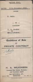
Conditions of sale by private contract dated 11th November, 1941 between H. Muir (seller) and C.E. Stokes & Mrs. J. Stokes (buyers) for land situate No. 718 High Street, Golden Square, together with 4-roomed weatherboard and rough cast dwelling and all sundry. Also all vendor's right title and interest in and to the adjoining land with a frontage to High street, and as fenced across the rear of the residence area land. Price 400 pounds.organization, business, h.a. & s.r wilkinson real estate -
 Bendigo Historical Society Inc.
Document - H.A. & S.R. WILKINSON COLLECTION: CONTRACT OF SALE
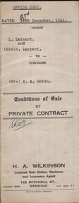
Conditions of sale by private contract dated 23rd December, 1941 between L. Lazzari and Mrs. E. Lazzari (sellers) and Mrs. M.A. Smith (buyer) for land situate No. 18 Burn Street, Golden Square being Crown allotment 8a section 46B land described in Crown grant volume 2325 folio 464944, together with 5-roomed weatherboard dwelling and all sundry. Price 340 poundsorganization, business, h.a. & s.r wilkinson real estate -
 Bendigo Historical Society Inc.
Document - H.A. & S.R. WILKINSON COLLECTION: CONTRACT OF SALE
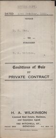
Conditions of sale by private contract dated 19th October, 1942 between D.R. Hay (seller) and H.A. Stirton (buyer) for land situate corner Creek and Hamann Streets, Bendigo, having a frontage of 85 links to Hamann Street by a depth of 134 links to Creek Street and adjoining allotments 6 and 4, and described in right to occupy residence area title No. 5429, together with 4-roomed weatherboard dwelling and all sundry. Price 270 pounds.organization, business, h.a. & s.r wilkinson real estate -
 Bendigo Historical Society Inc.
Document - H.A. & S.R. WILKINSON COLLECTION: CONTRACT OF SALE
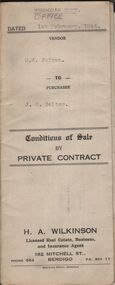
Conditions of sale by private contract dated 1st February, 1944 between D.B. Julyan (seller) and J.E. Salter (buyer) for that fruit and confectionary business situate 175 View Street, Bendigo, together with the goodwill, stock fittings Salter Spring balance scales, all shelving and ''Westinghouse'' Frigidaire as inspected by the purchaser and everything connected with said business in the shop and which belongs to the vendor. Price 300 pounds.organization, business, h.a. & s.r wilkinson real estate -
 Bendigo Historical Society Inc.
Document - H.A. & S.R. WILKINSON COLLECTION: CONTRACT OF SALE
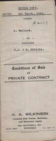
Conditions of sale by private contract dated 1st March, 1944 between A. Wallace (seller) and R.J. & E. Shields (buyer) for land situate in Ellis Street, Kennington containing six acres being described in certificate of title volume 4983 folio 995671 section H and being Crown allotments 529,529A, 529B. Crown grant volume 6111 folio 1222194, crown allotments 530, 530A section H. Crown grant volume 6307 folio 1261328, Crown allotment 529F section H. Crown grant volume 6307 folio 1261329, Crown allotment 529C section H. Crown grant volume 6307 folio 1261293, crown allotment 529D section H. Crown grant volume 6307 folio 1261294 crown allotment 529E section H. Together with 6-roomed weatherboard dwelling and all sundry. Price 1,300 pounds.organization, business, h.a. & s.r wilkinson real estate -
 Bendigo Historical Society Inc.
Document - H.A. & S.R. WILKINSON COLLECTION: CONTRACT OF SALE
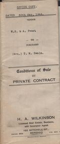
Conditions of sale by private contract dated 30th May, 1944 between W.S. & A. Frost (sellers) and Mrs. T. M. Swale (buyer) for land situate No. 212 Queen Street, Bendigo being Crown allotment 2 section 139C described in certificate of title volume 4557 folio 911246, together with 5-roomed weatherboard dwelling and all sundry. Price 385 pounds. Also attached 6 receipt 2 issued by George Rasmussen, 2 by Langley & Son, 1 by J.S. Barker plus 1 Unknown for various materials.organization, business, h.a. & s.r wilkinson real estate -
 Bendigo Historical Society Inc.
Document - H.A. & S.R. WILKINSON COLLECTION: CONTRACT OF SALE
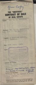
The Institute of Real Estate contract of sale dated 30th June, 1966 between Mr. C.J. Walters (seller) and Mr. C.J. Sandiford & Mrs. F.L. Sandiford (buyer) for land situate 3 Norfolk Street, Bendigo being part of Crown allotment 168, 311 and 312 section K described in certificate of title volume 6235 folio 960, together with all floor coverings, blinds, curtains and electric light fittings and shades. Price $7,000. Solicitors for vendor: Messrs. Watson, James & Rogers - Bull Street, Bendigo. Solicitor for purchaser: Messrs E.S. Cahill & Son - View Street, Bendigo.organization, business, h.a. & s.r wilkinson real estate -
 Bendigo Historical Society Inc.
Document - H.A. & S.R. WILKINSON COLLECTION: CONTRACT OF SALE
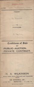
Conditions of sale by private contract dated 13th September, 1929 between F. Vincent (seller) and J. Taylor (buyer) for land situate Upper Road, California Gully being Crown allotment 292 section M at California Gully, Borough of Eaglehawk described in certificate of title volume 2959 folio 591717, together with 6-roomed weatherboard dwelling and all sundry. Price 210 pounds.organization, business, h.a. & s.r wilkinson real estate -
 Bendigo Historical Society Inc.
Document - H.A. & S.R. WILKINSON COLLECTION: CONTRACT OF SALE
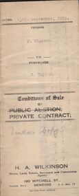
Conditions of sale by private contract dated 13th September, 1929 between F. Vincent (seller) and J. Taylor (buyer) for land situate Upper Road, California Gully being Crown allotment 292 section M at California Gully, Borough of Eaglehawk described in certificate of title volume 2959 folio 591717, together with 6-roomed weatherboard dwelling and all sundry. Price 210 pounds.organization, business, h.a. & s.r wilkinson real estate -
 Bendigo Historical Society Inc.
Document - H.A. & S.R. WILKINSON COLLECTION: CONTRACT OF SALE
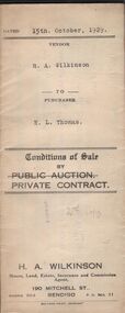
Conditions of sale by private contract dated 15th October, 1929 between R.A. Wilkinson (seller) and E.L. Thomas for freehold land situate 18 McClure Street, Ironbark being Crown allotment 497 section K described in Crown grant volume 2471 folio 494141, together with 5-roomed stone, wood and brick dwelling and all sundry. Price 270 pounds.organization, business, h.a. & s.r wilkinson real estate -
 Bendigo Historical Society Inc.
Document - H.A. & S.R. WILKINSON COLLECTION: CONTRACT OF SALE
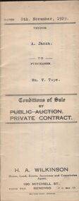
Conditions of sale by private contract dated 8th November, 1929 between A. Jacka (seller) and W. V. Tope (buyer) for land situate corner McKenzie and Wade Streets, Golden Square described in certificate of registration as residence area no. ? Together with 5-roomed weatherboard dwelling and all sundry, also gas stove, wood stove. Electric light fittings, bath, hand basin, copper and troughs. Price 620 pounds.organization, business, h.a. & s.r wilkinson real estate -
 Bendigo Historical Society Inc.
Document - H.A. & S.R. WILKINSON COLLECTION: CONTRACT OF SALE
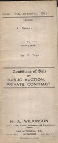
Conditions of sale by private contract dated 8th November, 1929 between A. Jacka (seller) and W. V. Tope (buyer) for land situate corner McKenzie and Wade Streets, Golden Square described in certificate of registration as residence area no. ? Together with 5-roomed weatherboard dwelling and all sundry, also gas stove, wood stove. Electric light fittings, bath, hand basin, copper and troughs. Price 620 pounds.organization, business, h.a. & s.r wilkinson real estate -
 Bendigo Historical Society Inc.
Document - H.A. & S.R. WILKINSON COLLECTION: CONTRACT OF SALE
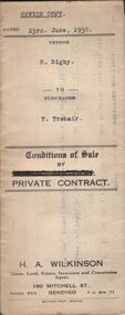
Conditions of sale by private contract dated 23rd June, 1930 between R. Rigby (seller) and T. Trahair (buyer) for land situate 62 Ophir Street, Golden Square described in certificate of registration as residence area No. 31146, together with weatherboard dwelling and all sundry. Price 342 pounds 10 shillings.organization, business, h.a. & s.r wilkinson real estate -
 Bendigo Historical Society Inc.
Document - H.A. & S.R. WILKINSON COLLECTION: CONTRACT OF SALE
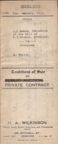
Conditions of sale by private contract dated 7th January, 1931 between A.E. Leech executrix of the will of E.J. Cronin deceased (seller) and M. Taylor (buyer) for land situate in Maple Street, Bendigo being the land described in certificate of registration as residence area No. 31152, together with 6-roomed weatherboard and brick dwelling and all sundry, also wood fire stove and built in copper. Price 220 poundsorganization, business, h.a. & s.r wilkinson real estate -
 Bendigo Historical Society Inc.
Document - H.A. & S.R. WILKINSON COLLECTION: CONTRACT OF SALE
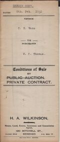
Conditions of sale by private contract dated 8th February, 1932 between C. N. Vane (seller) and W.C. Thomas (buyer) for land situate corner Cobden and Brougham Streets, Bendigo being part of Crown allotment 6 section 64C described in certificate of title volume 2927 folio 585303 and at present occupied by tenant, together with 5-roomed weatherboard dwelling and all sundry. Price 375 pounds.organization, business, h.a. & s.r wilkinson real estate -
 Bendigo Historical Society Inc.
Document - H.A. & S.R. WILKINSON COLLECTION: CONTRACT OF SALE
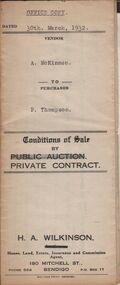
Conditions of sale by private contract dated 30th March, 1932 between A. McKinnon (seller) and P. Thompson (buyer) for land situate in Murphy Street, Bendigo being the balance of the subdivision unsold of Crown allotment 151,270A, 271A, 271C, 271R, 195, 196, 270C, 271B and 271D described in certificate of title volume 2666 folio 533101, and being the land at present occupied by the vendor, not including the allotments or read showed on plan of subdivision. Together with weatherboard dwelling and all sundry including galvanized iron tank and stand, water trough and loose timber in paddock but does not include any window or verandah blinds. Price 800 pounds.organization, business, h.a. & s.r wilkinson real estate -
 Bendigo Historical Society Inc.
Document - H.A. & S.R. WILKINSON COLLECTION: CONTRACT OF SALE
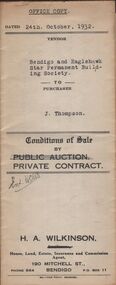
Conditions of sale by private contract dated 24th October, 1932 between Bendigo and Eaglehawk Star Permanent Building Society (seller) and J. Thompson (buyer) for land situate Lily Street, Bendigo being Crown allotment 1B section 14B described in Crown grant volume 258 folio 51486, together with all dwellings and erections on the said land. Price 315 pounds.organization, business, h.a. & s.r wilkinson real estate -
 Bendigo Historical Society Inc.
Document - H.A. & S.R. WILKINSON COLLECTION: CONTRACT OF SALE
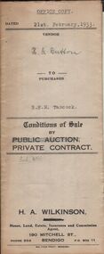
Conditions of sale by private contract dated 21st February, 1933 between H.G. Button (seller) and B.E. M. Tancock for land situate 31 Creel Street, Bendigo being part of Crown allotment 31 section 127C described in certificate of title volume 2313 folio 462535, together with 5-roomed weatherboard and brick dwelling, at present occupied by Mr. Malkin as tenant, and all sundry outbuildings on the said land. Price 160 pounds.organization, business, h.a. & s.r wilkinson real estate -
 Bendigo Historical Society Inc.
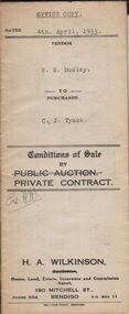
Document - H.A. & S.R. WILKINSON COLLECTION: CONTRACT OF SALE
Conditions of sale by private contract dated 4th April, 1933 between E.M. Dudley (seller) and C.J. Tyack for land situate No.161 honeysuckle street, Bendigo being land described in certificates of registration as residence area no. 32525 and residence area no. 32526, together with 6-roomed weatherboard dwelling, garage and all sundry outbuildings and erections on said land. Also all electric light fittings, duck blinds in sleep-out, all wire doors and windows, window blinds and name plate. Price 545 pounds.organization, business, h.a. & s.r wilkinson real estate -
 Bendigo Historical Society Inc.
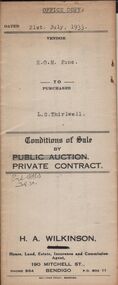
Document - H.A & S.R. WILKINSON COLLECTION: CONTRACT OF SALE
Conditions of sale by private contract dated 21st July, 1933 between E.O.M. Fone (seller) and L.G. Thirlwell (buyer) for land situate Hargreaves Street West, Bendigo being part of Crown allotment 5 section 141C described in certificate of title volume 5196 folio 1039198, together with sleep-out, laundry, sheds and all sundry. Price 200 pounds.organization, business, h.a. & s.r wilkinson real estate -
 Bendigo Historical Society Inc.
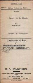
Document - H.A. & S.R. WILKINSON COLLECTION: CONTRACT OF SALE
Conditions of sale by private contract dated 19th October, 1933 between Mrs. P.I. Clark (seller) and Miss M. Thompson (buyer) for land situate McIvor Road, Bendigo being lots 2,5 and 6 on plan of subdivision No. 13539 and being Crown allotment 196 and parts of Crown allotments 151,195 and 270A section H described in certificate of title volume 5756 folio 1151098, together with all fences and erections thereon. Price 150 pounds.organization, business, h.a. & s.r wilkinson real estate -
 Bendigo Historical Society Inc.
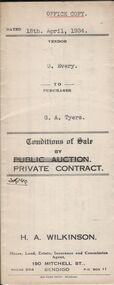
Document - H.A. & S.R. WILKINSON COLLECTION: CONTRACT OF SALE
Conditions of sale by private contract dated 18th April, 1934 between G. Every (seller) and G.A. Tyers (buyer) for land situate White Hills Road, White Hills being part of Crown allotment 8 section 19, described in deed of conveyance No. 426 book No. 497, together with weatherboard dwelling and all sundry. Price 500 pounds.organization, business, h.a. & s.r wilkinson real estate -
 Bendigo Historical Society Inc.
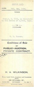
Document - H.A. & S.R. WILKINSON COLLECTION: CONTRACT OF SALE
Conditions of sale by private contract dated 7th May, 1934 between Miss M.H. Wild as executrix in the estate of E. Wild deceased (seller) and E.T. Thomas (buyer) for land situate Hargreaves Street corner Wattle Street, Bendigo being Crown allotment 25 section 97C described in certificate of title volume 1562 folio 332318. Also that piece of land adjoining above being land described in residence area certificate No.30319 in the books of the mining registrar at Bendigo. Together with 6-roomedweatherboard dwelling and all sundry. Price 350 pounds.organization, business, h.a. & s.r wilkinson real estate -
 Bendigo Historical Society Inc.
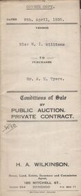
Document - H.A. & S.R. WILKINSON COLLECTION: CONTRACT OF SALE
Conditions of sale by private contract dated 8th April, 1935 between Miss N.I. Williams (seller) and Mr. A. H. Tyers (buyer) for fruit and confectionary business situated 113 Mitchell Street, Bendigo comprising: stocks and all fittings wherein the four walls and all goodwill of the said business, also gas stove in the kitchen and the sleep out in the yard. Price 130 pounds. Also attached a letter addressed to Miss Williams regarding tenancy of property known as ''The first and Last Café'' at the price of 1 pound 5 shillings weekly. The letter is signed by Favaloro and dated 24th February, 1934.organization, business, h.a. & s.r wilkinson real estate