Showing 2296 items matching "railway line"
-
 Bendigo Historical Society Inc.
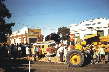
Slide - BENDIGO ASSORTED 1603, 1970
... Train being brought down from railway line Between Buclell...Slide. Train being brought down from railway line Between...SLIDE Bendigo Train being brought down from railway line ...Slide. Train being brought down from railway line Between Buckell and Jeffery Store No.1 and Store No.2, to be postitioned in gardens in Mitchell Street. Dated Feb 1970. BCV-TV van in centre of slide.slide, bendigo, train being brought down from railway line between buclell and jeffery store no.1 and store no.2, to be postitioned in gardens in mitchell street. dated feb 1970. bcv-tv van in centre of slide. -
 Federation University Historical Collection
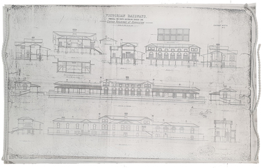
Plan, Copy of a Plan of Serviceton Railway Station Building, 1888
... and the Adelaide-Wolseley railway line of South Australia joined...Copy of plan for the Serviceton Railway Line... railway line of South Australia joined. The Railway Station ...The Serviceton Railway Station was completed in 1889 , with the Colony of Victoria and the Colony of South Australia sharing the cost. Ut was at Serviceton the the Victorian rail line and the Adelaide-Wolseley railway line of South Australia joined. The Railway Station included customs offices which were no longer necessary after the Federation of Australian States in 1901. ( https://en.wikipedia.org/wiki/Serviceton,_Victoria, accessed 30 August 2021)Copy of plan for the Serviceton Railway Linerailway, servicetone railway station, plan, serviceton -
 Eltham District Historical Society Inc
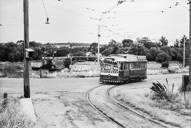
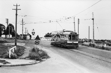
Photograph, Bendigo Tramways No. 7 about to arrive at its terminus in North Bendigo near the intersection of Thunder Street and Moray Crescent, January 1972, Jan 1972
... , Moray Crescent, North Bendigo, railway crossing, Railway Line... Crescent where it terminated alongside the railway line in North... Crescent where it terminated alongside the railway line in North ...The tram line proceeds up to the left just pass Moray Crescent where it terminated alongside the railway line in North Bendigo in 1972Digital TIFF file Scan of 35mm Ilford FP3 black and white negative transparencybendigo, bendigo tramways no. 7, george coop collection, moray crescent, north bendigo, railway crossing, railway line,thunder street, tram -
 Eltham District Historical Society Inc
Photograph, Bendigo Tramways No. 7 departs from Thunder Street in North Bendigo en route to Golden Square, Bendigo, January 1972, Jan 1972
... , moray crescent, north bendigo, railway crossing, railway line... Crescent where it terminated alongside the railway line in North... Crescent where it terminated alongside the railway line in North ...The tram line proceeds up to the left just pass Moray Crescent where it terminated alongside the railway line in North Bendigo in 1972Digital TIFF file Scan of 35mm Ilford FP3 black and white negative transparencybendigo, bendigo tramways no. 7, george coop collection, moray crescent, north bendigo, railway crossing, railway line, thunder street, tram -
 Eltham District Historical Society Inc
Photograph, Looking north along Main Road from Cecil Street intersection, Eltham, February 1968, Feb 1968
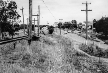
... railway line... under railway line to the Diamond Creek and Cecil Street sign.... under railway line to the Diamond Creek and Cecil Street sign ...Shows position of under road water course, which also went under railway line to the Diamond Creek and Cecil Street sign.In February 1968 an unknown person took a series of photos from the Eltham Hotel at Pitt Street heading north along Main Road through the shopping centre to just north of Elsa Court covering the length of the section of Main Road which was duplicated shortly thereafter. Shows the condition and environment of the streesscape of Main Road, Eltham immediately prior to the duplication between Pitt Street and Elsa Court through the shopping centre. Also shows a number of shops and businesses that operated at that time.Black and white photographduplication, eltham, main road, cecil street, railway line, watercourse, floods -
 Eltham District Historical Society Inc
Photograph, Hurstbridge - Showing Railway Station
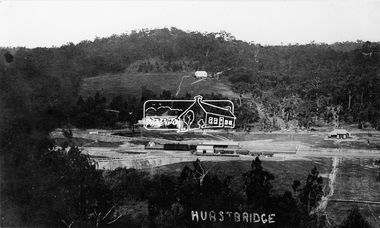
... railway line... of Hurstbridge. The new railway line and station and accompanying works... of Hurstbridge. The new railway line and station and accompanying works ...View overlooking the township and surrounding hills of Hurstbridge. The new railway line and station and accompanying works are central. The extension from Eltham to Hurstbridge opened on 2 January 1912.This photo forms part of a collection of photographs gathered by the Shire of Eltham for their centenary project book, "Pioneers and Painters: 100 years of the Shire of Eltham" by Alan Marshall (1971). The collection of over 500 images is held in partnership between Eltham District Historical Society and Yarra Plenty Regional Library (Eltham Library) and is now formally known as 'The Shire of Eltham Pioneers Photograph Collection.' It is significant in being the first community sourced collection representing the places and people of the Shire's first one hundred years.Digital imagesepp, shire of eltham pioneers photograph collection, diamond creek, hurstbridge, railway station, railroad, railway line -
 Sunbury Family History and Heritage Society Inc.
Photograph, 17 December 1985
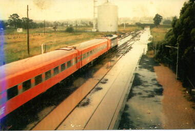
... of the railway line. ... at a station where the railway line has been flooded. A storage silo... silo on the west side of the railway line. sunbury railway ...On 17th December 1985 record torrential rain fell in Sunbury, which flooded the main Melbourne Bendigo rail line and disrupted traffic. The photograph is looking to the north of the station and takes in the historic Macedon Street bridge and the open ground with the storage silo on the west side of the railway line. A coloured photograph of a former V Line train stopped at a station where the railway line has been flooded. A storage silo occupies vac ant ground adjacent to the railway line.sunbury railway station, storage silos, horne street -
 Federation University Historical Collection
Document - Plan, Mathew Gibson, Centre for Environmental Management, Ballarat Technology Park Conservation Plan, 1997, 1997
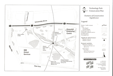
... ballarat-buninyong railway line...-Buninyong Railway line, Greenhill Enterprise Centre and IBM Global... ballarat-buninyong railway line canadian wetlands brick railway ...The Ballarat Technology Park is on the Mount Helen Campus.A4 photocopy of a plan of the Ballarat Technology Park showing features of conservation significance. The plan includes the Canadian Creek, an historic hand-made brick culvert, Canadian Wetland Development, early wooden bridge, old path of the Ballarat-Buninyong Railway line, Greenhill Enterprise Centre and IBM Global Services.ballarat technology park, greenhill enterprise centre, ibm global enterprises, ballarat-buninyong railway line, canadian wetlands, brick railway culvert, canadian creek, riparian woodland, yarra gum, swamp gum, blackwood, remnant vegetation, scent bark, narrow-leaf peppermint, messmate, centre for environmental management, mount helen campus -
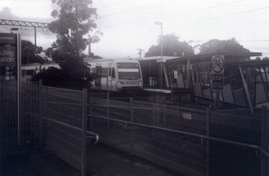
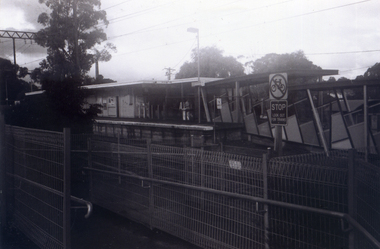
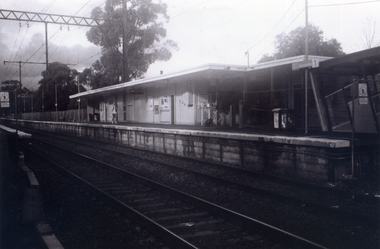
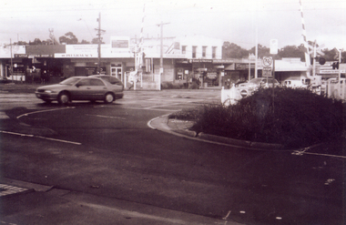
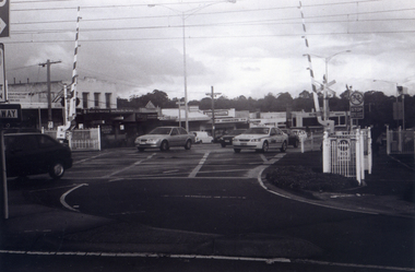
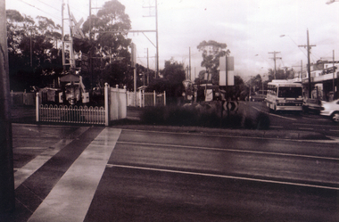
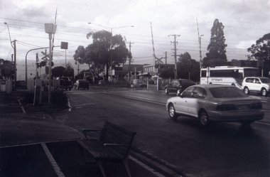
 Whitehorse Historical Society Inc.
Photograph, Nunawading Railway Station, 1/06/2009
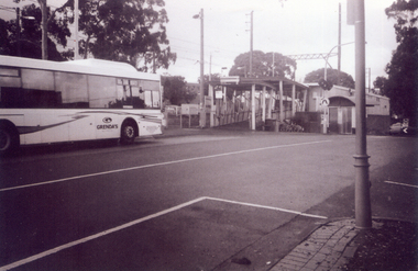
... redevelopment of railway line/springvale road.... Railway Station prior to the lowering of the railway line... of the Nunawading Railway Station prior to the lowering of the railway line ...One of a collection of photographs taken of the Nunawading Railway Station prior to the lowering of the railway line and building of the new railway station on the western side of Springvale Road so that the Springvale Road Rail Crossing can be eliminated.Black & white photograph of he precinct surrounding the Nunawading Station and the Springvale Road Railway crossing. This photograph is of the southern entrance from Station Street. Note the Grenda Bus|See NP 3545 to NP3567for the complete set of photographsnunawading railway station, springvale road nunawading, redevelopment of railway line/springvale road., station street nunawading -
 Whitehorse Historical Society Inc.
Photograph, The Railway Crossing from Station Street, 1/06/2009
... redevelopment of railway line/springvale road.... Railway Station prior to the lowering of the railway line... of the Nunawading Railway Station prior to the lowering of the railway line ...One of a collection of photographs taken of the Nunawading Railway Station prior to the lowering of the railway line and building of the new railway station on the western side of Springvale Road so that the Springvale Road Rail Crossing can be eliminated.Black & white photograph of he precinct surrounding the Nunawading Station and the Springvale Road Railway crossing. This photograph is of the crossing from Station Street. The liquor on the corner of Springvale Road and Oval way is in the background. See NP 3545 to NP3567 for the complete set of photographsnunawading railway station, springvale road nunawading, redevelopment of railway line/springvale road., oval way nunawading -
 Whitehorse Historical Society Inc.
Photograph, The Railway Crossing from Corner of Springvale Road & Station, 1/06/2009
... redevelopment of railway line/springvale road.... Railway Station prior to the lowering of the railway line... of the Nunawading Railway Station prior to the lowering of the railway line ...One of a collection of photographs taken of the Nunawading Railway Station prior to the lowering of the railway line and building of the new railway station on the western side of Springvale Road so that the Springvale Road Rail Crossing can be eliminated.Black & white photograph of he precinct surrounding the Nunawading Station and the Springvale Road Railway crossing. This photograph is of the Railway Crossing from corner of Springvale Road & Station. See NP 3545 to NP3567for the complete set of photographsnunawading railway station, springvale road, nunawading, redevelopment of railway line/springvale road., station street nunawading -
 Whitehorse Historical Society Inc.
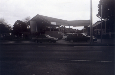
Photograph, Service Station -Now Works Site Office, 1/06/2009
... redevelopment of railway line/springvale road.... Railway Station prior to the lowering of the railway line... of the Nunawading Railway Station prior to the lowering of the railway line ...One of a collection of photographs taken of the Nunawading Railway Station prior to the lowering of the railway line and building of the new railway station on the western side of Springvale Road so that the Springvale Road Rail Crossing can be eliminated.Black & white photograph of he precinct surrounding the Nunawading Station and the Springvale Road Railway crossing. This photograph is former Service Station on west side of Springvale Road. Now works site office. See NP 3545 to NP3567 for the complete set of photographsnunawading railway station, springvale road nunawading, redevelopment of railway line/springvale road. -
 Whitehorse Historical Society Inc.
Photograph, Railway Track Looking East, 1/06/2009
... redevelopment of railway line/springvale road.... Railway Station prior to the lowering of the railway line... of the Nunawading Railway Station prior to the lowering of the railway line ...One of a collection of photographs taken of the Nunawading Railway Station prior to the lowering of the railway line and building of the new railway station on the western side of Springvale Road so that the Springvale Road Rail Crossing can be eliminated.Black & white photograph of he precinct surrounding the Nunawading Station and the Springvale Road Railway crossing. This photograph is of the railway track looking east from railway crossing in Springvale road. Note the railway station in the distance. See NP 3545 to NP3567 for the complete set of photographsnunawading railway station, springvale road nunawading, redevelopment of railway line/springvale road. -
 Whitehorse Historical Society Inc.
Photograph, Railway tracks looking west, 1/06/2009
... redevelopment of railway line/springvale road.... Railway Station prior to the lowering of the railway line... of the Nunawading Railway Station prior to the lowering of the railway line ...One of a collection of photographs taken of the Nunawading Railway Station prior to the lowering of the railway line and building of the new railway station on the western side of Springvale Road so that the Springvale Road Rail Crossing can be eliminated.Black & white photograph of he precinct surrounding the Nunawading Station and the Springvale Road Railway crossing. This photograph is the railway crossing and tracks looking west to Blackburn. See NP 3545 to NP3567 for the complete set of photographsnunawading railway station, springvale road nunawading, redevelopment of railway line/springvale road. -
 Whitehorse Historical Society Inc.
Photograph, Looking across crossing towards liquor store, 1/06/2009
... redevelopment of railway line/springvale road.... Railway Station prior to the lowering of the railway line... of the Nunawading Railway Station prior to the lowering of the railway line ...One of a collection of photographs taken of the Nunawading Railway Station prior to the lowering of the railway line and building of the new railway station on the western side of Springvale Road so that the Springvale Road Rail Crossing can be eliminated.Black & white photograph of he precinct surrounding the Nunawading Station and the Springvale Road Railway crossing. This photograph is the view looking across railway crossing towards liquor store. See NP 3545 to NP3567 for the complete set of photographsnunawading railway station, springvale road nunawading, redevelopment of railway line/springvale road. -
 Whitehorse Historical Society Inc.
Photograph, Nunawading Station looking from the north side, 1/06/2009
... redevelopment of railway line/springvale road.... Railway Station prior to the lowering of the railway line... of the Nunawading Railway Station prior to the lowering of the railway line ...One of a collection of photographs taken of the Nunawading Railway Station prior to the lowering of the railway line and building of the new railway station on the western side of Springvale Road so that the Springvale Road Rail Crossing can be eliminated.Black & white photograph of he precinct surrounding the Nunawading Station and the Springvale Road Railway crossing. This photograph is the station looking from the entrance of station on the north side of the tracks. See NP 3545 to NP3567 for the complete set of photographsnunawading railway station, springvale road nunawading, redevelopment of railway line/springvale road. -
 Whitehorse Historical Society Inc.
Photograph, Railway Platform from south side, 1/06/2009
... redevelopment of railway line/springvale road.... Railway Station prior to the lowering of the railway line... of the Nunawading Railway Station prior to the lowering of the railway line ...One of a collection of photographs taken of the Nunawading Railway Station prior to the lowering of the railway line and building of the new railway station on the western side of Springvale Road so that the Springvale Road Rail Crossing can be eliminated.Black & white photograph of the precinct surrounding the Nunawading Station and the Springvale Road Railway crossing. This photograph is railway station looking from north side of station. See NP 3545 to NP3567 for the complete set of photographsnunawading railway station, springvale road nunawading, redevelopment of railway line/springvale road. -
 Whitehorse Historical Society Inc.
Photograph, Station seen from north side-Platform, 1/06/2009
... redevelopment of railway line/springvale road.... Railway Station prior to the lowering of the railway line... of the Nunawading Railway Station prior to the lowering of the railway line ...One of a collection of photographs taken of the Nunawading Railway Station prior to the lowering of the railway line and building of the new railway station on the western side of Springvale Road so that the Springvale Road Rail Crossing can be eliminated.Black & white photograph of he precinct surrounding the Nunawading Station and the Springvale Road Railway crossing. This photograph is a close up view of the south platform at Nunawading from the north side.|See NP 3545 to NP3567for the complete set of photographsnunawading railway station, springvale road nunawading, redevelopment of railway line/springvale road. -
 Whitehorse Historical Society Inc.
Photograph, Looking to Booking Office on North side of Nunawading Station, 1/06/2009
... redevelopment of railway line/springvale road.... Railway Station prior to the lowering of the railway line... of the Nunawading Railway Station prior to the lowering of the railway line ...One of a collection of photographs taken of the Nunawading Railway Station prior to the lowering of the railway line and building of the new railway station on the western side of Springvale Road so that the Springvale Road Rail Crossing can be eliminated.Black & white photograph of he precinct surrounding the Nunawading Station and the Springvale Road Railway crossing. This photograph is the entrance to the Booking Office for trains from Nunawading travelling east. See NP 3545 to NP3567 for the complete set of photographsnunawading railway station, springvale road nunawading, redevelopment of railway line/springvale road. -
 Whitehorse Historical Society Inc.
Photograph, Nunawading Station - North Side, 1/06/2009
... redevelopment of railway line/springvale road.... Railway Station prior to the lowering of the railway line... of the Nunawading Railway Station prior to the lowering of the railway line ...One of a collection of photographs taken of the Nunawading Railway Station prior to the lowering of the railway line and building of the new railway station on the western side of Springvale Road so that the Springvale Road Rail Crossing can be eliminated.Black & white photograph of he precinct surrounding the Nunawading Station and the Springvale Road Railway crossing. This photograph is of the Booking Office and Waiting Rooms on the North side of the Nunawading Station . See NP 3545 to NP3567 for the complete set of photographsnunawading railway station, springvale road nunawading, redevelopment of railway line/springvale road. -
 Whitehorse Historical Society Inc.
Photograph, General View of Nunawading Station, 1/06/2009
... redevelopment of railway line/springvale road.... Railway Station prior to the lowering of the railway line... of the Nunawading Railway Station prior to the lowering of the railway line ...One of a collection of photographs taken of the Nunawading Railway Station prior to the lowering of the railway line and building of the new railway station on the western side of Springvale Road so that the Springvale Road Rail Crossing can be eliminated.Black & white photograph of he precinct surrounding the Nunawading Station and the Springvale Road Railway crossing. This photograph is view of the Nunawading Railway Station from Walker Road, showing the North an South Platforms. See NP 3545 to NP3567 for the complete set of photographsnunawading railway station, springvale road nunawading, redevelopment of railway line/springvale road., walkers road nunawading -
 Whitehorse Historical Society Inc.
Photograph, Liquor Store fro Silver Grove Car park, 1/06/2009
... redevelopment of railway line/springvale road.... Railway Station prior to the lowering of the railway line... of the Nunawading Railway Station prior to the lowering of the railway line ...One of a collection of photographs taken of the Nunawading Railway Station prior to the lowering of the railway line and building of the new railway station on the western side of Springvale Road so that the Springvale Road Rail Crossing can be eliminated.Black & white photograph of the precinct surrounding the Nunawading Station and the Springvale Road Railway crossing. This photograph is the rear of the liquor store in Springvale Road.cSee NP 3545 to NP3567for the complete set of photographsnunawading railway station, springvale road nunawading, redevelopment of railway line/springvale road. -
 Whitehorse Historical Society Inc.
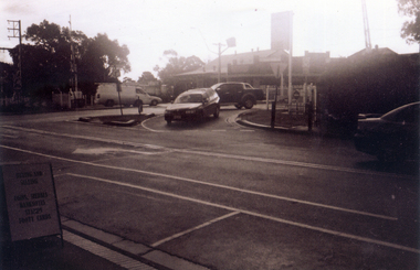
Photograph, Railway crossing on Springvale Road, 1/06/2009
... redevelopment of railway line/springvale road.... Railway Station prior to the lowering of the railway line... of the Nunawading Railway Station prior to the lowering of the railway line ...One of a collection of photographs taken of the Nunawading Railway Station prior to the lowering of the railway line and building of the new railway station on the western side of Springvale Road so that the Springvale Road Rail Crossing can be eliminated.Black & white photograph of the precinct surrounding the Nunawading Station and the Springvale Road Railway crossing. This photograph is the railway crossing with Springvale Road, Nunawading, taken from the north west corner looking over crossing to some of the Nunawading shops. See NP 3545 to NP3567 for the complete set of photographsnunawading railway station, springvale road nunawading, redevelopment of railway line/springvale road., nunawading recreation centre -
 Whitehorse Historical Society Inc.
Photograph, Railway Crossing from the north, 1/06/2009
... redevelopment of railway line/springvale road.... Railway Station prior to the lowering of the railway line... of the Nunawading Railway Station prior to the lowering of the railway line ...One of a collection of photographs taken of the Nunawading Railway Station prior to the lowering of the railway line and building of the new railway station on the western side of Springvale Road so that the Springvale Road Rail Crossing can be eliminated.Black & white photograph of the precinct surrounding the Nunawading Station and the Springvale Road Railway crossing. This photograph is of the railway crossing of Springvale Road, Nunawading, looking to the south of the shops. See NP 3545 to NP3567 for the complete set of photographsnunawading railway station, springvale road nunawading, redevelopment of railway line/springvale road. -
 Whitehorse Historical Society Inc.
Photograph, Pedestrian Crossing & Nunawading Railway Station, 1/06/2009
... redevelopment of railway line/springvale road.... Railway Station prior to the lowering of the railway line... of the Nunawading Railway Station prior to the lowering of the railway line ...One of a collection of photographs taken of the Nunawading Railway Station prior to the lowering of the railway line and building of the new railway station on the western side of Springvale Road so that the Springvale Road Rail Crossing can be eliminated.Black & white photograph of the precinct surrounding the Nunawading Station and the Springvale Road Railway crossing. This photograph is looking over the south side of the intersection in Springvale, to the pedestrian crossing and the Railway Station. The shopping centre is on the right hand side. See NP 3545 to NP3567 for the complete set of photographsnunawading railway station, springvale road nunawading, redevelopment of railway line/springvale road. -
 Whitehorse Historical Society Inc.
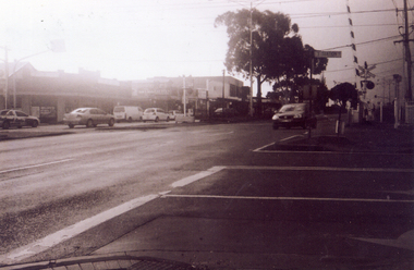
Photograph, Railway Crossing from the south, 1/06/2009
... redevelopment of railway line/springvale road.... Railway Station prior to the lowering of the railway line... of the Nunawading Railway Station prior to the lowering of the railway line ...One of a collection of photographs taken of the Nunawading Railway Station prior to the lowering of the railway line and building of the new railway station on the western side of Springvale Road so that the Springvale Road Rail Crossing can be eliminated.Black & white photograph of the precinct surrounding the Nunawading Station and the Springvale Road Railway crossing. This photograph is south side of the crossing looking north. See NP 3545 to NP3567 for the complete set of photographsnunawading railway station, springvale road nunawading, redevelopment of railway line/springvale road. -
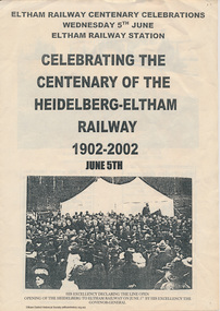 Eltham District Historical Society Inc
Folder, Centenary of the Heidelberg to Eltham Railway 1902-2002, 2001-2002
... hurstbridge railway line... of the Heidelberg Eltham railway line in 2002. Includes copies of letters... of the Heidelberg Eltham railway line in 2002. Includes copies of letters ...Meeting agenda to form Eltham Historical Society sub commttee for an event to acknowledge the centenary of the Heidelberg Eltham railway line in 2002. Includes copies of letters to various potential stakeholders and partners. A3 folded information leaftlet with historical information and photographs8 PagesHG Folders 110harry gilham collection, heidelberg-eltham railway extension, hurstbridge railway line, centenary celebrations, eltham district historical society -
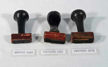 Orbost & District Historical Society
railway stamps, c. 1916-1987
... railway-stamp railway-history orbost-railway-line... line which closed in 1987. The Bairnsdale-Orbost railway... line which closed in 1987. The Bairnsdale-Orbost railway ...Used by station staff on the Bairnsdale to Orbost railway line which closed in 1987. The Bairnsdale-Orbost railway was opened in 1916 to serve the agricultural and timber industry. Because of the decline in traffic and heavy operating costs, the line was finally closed in August, 1987.This item is associated with the history of the Orbost-Bairnsdale railway line and therefore reflects the role that the rail line played in the social and economic history of Orbost.Three stamps used by Victorian Railways, for WAYGARA, BRUTHEN, and ORBOST stations. All stamps have black painted handles. The stamp is made of rubber and the handles are wood.WAYGARA BRUTHEN ORBOSTrailway-stamp railway-history orbost-railway-line -
 Whitehorse Historical Society Inc.
Map, Map 1892. Nunawading Shire, 1892
... Shows railway line including spur from Box Hill to Box Hill.... Shows railway line including spur from Box Hill to Box Hill... Mitcham melbourne Shows railway line including spur from Box Hill ...Duplicated same as ND5060 Map of Shire of Nunawading.Duplicated same as ND5060 Map of Shire of Nunawading. Shows railway line including spur from Box Hill to Box Hill Brick Co.Duplicated same as ND5060 Map of Shire of Nunawading. maps, shire of nunawading, railways, box hill brick company -
Whitehorse Historical Society Inc.
Article, Turn Minor Upgrade to Major one, 2015
... of the railway line.... of the railway line.... & south of the railway line. Blackburn Village Shopping Centre ...Blackburn traders are lobbying the State Government to rebuild the Blackburn Station underground when the level crossing is removed.Blackburn traders are lobbying the State Government to rebuild the Blackburn Station underground when the level crossing is removed, in order to unite the shopping centre north & south of the railway line.Blackburn traders are lobbying the State Government to rebuild the Blackburn Station underground when the level crossing is removed. blackburn village shopping centre, blackburn railway crossing, blackburn railway station