Showing 223 items
matching road widening
-
 Halls Gap & Grampians Historical Society
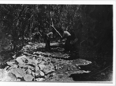
Photograph - B/W, C 1920s
Men have started to form the Mt Victory Road. Until the 1900's access to the Stoney Creek gorge was via a winding bridal jinker track. Increased traffic lead to much of this route being widened into what became known as Bluff Road. Within a few years the route was further improved and was officially named Mount Victory Road in 1930.Photo shows 3 men working with pick and shovel on roadPick and shovel Mt Victory Rdaccess routes, roads, access routes, road building -
 Halls Gap & Grampians Historical Society
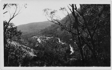
Postcard - Sepia, C 1920s
The road winding up Stoney Creek Gorge with Elephant Hide, the rocky slope in the picture, on the left. Sections of the earlier 19th century bridal track, which was later widened to become a jinker track, can be seen above the new road.Postcard shows Mt Victory Rd unsealed Elephant's hide on leftPostcard Correspondence Address only Kodak Mt Vic Roadaccess routes, mt victory rd, roads -
 Eltham District Historical Society Inc
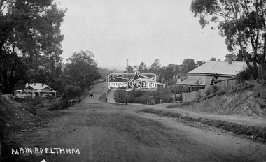
Negative - Photograph, Main Road, Eltham, c.1915
... . The house was demolished in 1968 during the widening of Main Road.... The house was demolished in 1968 during the widening of Main Road ...Sending postcards to family and friends including short messages was a common form of communication in the early 20th century from 1905 to the 1940s. Many were collected and kept in albums. This scene is viewed looking north along Main Road from near Bridge Street. The old Baker’s shop (Burgoyne’s store) on the corner of York is on the right. Also visible is the footpath dug by hand c.1906 between Yoirk Street and Bridge Street. On the left is ‘Derril’ or more commonly known as the Gahan House after it was purchased by Walter Ernest and Alice Miriam Gahan in 1924, on the western side of Main Road near the present-day site of Shillinglaw Cottage where they remained till about 1960 when Walter died. The house was demolished in 1968 during the widening of Main Road. In the distance on the bend is the Shillinglaw cottage with the Shillinglaw trees out front of the cottage. On the eastern side at the top of the hill (visible immediately to the left of the bakery) is the new St Mary’s Catholic Church on Henry Street near Main Road. The church site was relocated c.1912 from further south along Main Road (near Wingrove Cottage) in order to be more central to the congregation following the shifting of the township away from Little Eltham and closer to the railway station. It was subsequently destroyed by fire in 1961. On the back of the postcard is written: Printed Post Empire Care - correspondence - Address only - stamp Written in ink: 15 ? 1920 Many happy of the day I hope you and ? will have a very pleasant trip ? a great time when you reach England. ? & best wishes from your sincere friend E Harper?This photo forms part of a collection of photographs gathered by the Shire of Eltham for their centenary project book,"Pioneers and Painters: 100 years of the Shire of Eltham" by Alan Marshall (1971). The collection of over 500 images is held in partnership between Eltham District Historical Society and Yarra Plenty Regional Library (Eltham Library) and is now formally known as the 'The Shire of Eltham Pioneers Photograph Collection.' It is significant in being the first community sourced collection representing the places and people of the Shire's first one hundred years.Digital image 4 x 5 inch B&W Neg Sepia Postcard 9 x 14 cm 35mm positive transparencyshire of eltham pioneers photograph collection, eltham, main road, gahan house, bakery, footpath, postcard, shillinglaw cottage, shillinglaw trees, st marys catholic church, york street, michael aitken collection -
 Eltham District Historical Society Inc
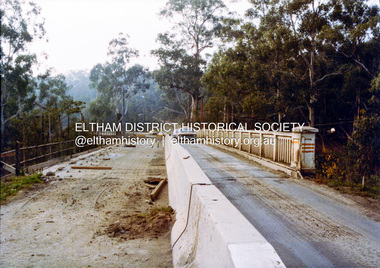
Photograph, Ruth H. Pendavingh, Widening of Main Road Bridge over the Diamond Creek, Eltham, 1984c
... Widening of Main Road Bridge over the Diamond Creek, Eltham...- early 2000) Widening of Main Road Bridge over the Diamond Creek ...Three colour photographs of the construction work of the widening works of the bridge over the Diamond Creek, Eltham, near Lower Eltham Park Victoria. The bridge re-opened on October 25, 1984. (EDHS Chronology of known local events 1835- early 2000) eltham, main road, main road bridge, bridges, construction, diamond creek (river) -
 Eltham District Historical Society Inc
Photograph, Ruth H. Pendavingh, Widening of Main Road Bridge over the Diamond Creek, Eltham, 1984c
... Widening of Main Road Bridge over the Diamond Creek, Eltham...- early 2000) Widening of Main Road Bridge over the Diamond Creek ...Three colour photographs of the construction work of the widening works of the bridge over the Diamond Creek, Eltham, near Lower Eltham Park Victoria. The bridge re-opened on October 25, 1984. (EDHS Chronology of known local events 1835- early 2000) eltham, main road, main road bridge, bridges, construction, diamond creek (river) -
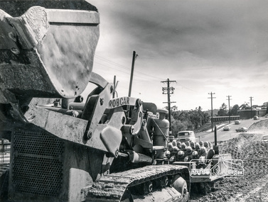
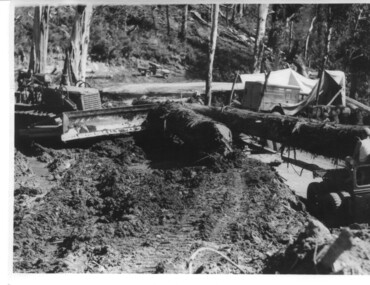 Kiewa Valley Historical Society
Photograph, logging at McKay Creek, Logging at McKay Creek, c1950's
This photograph was probably taken at the site of McKay Creek Power Station. Excavation of this site did not commence until 1951 but road access(a narrow track) was provided in 1948 and widened in 1954. The logs would have been milled for timber at the State Electricity Commission's mill at Howman's Gap and thus provided a much needed source of timber for construction of camps and houses as there was a general of shortage of this commodity. Because of trouble with landslides in this area, a decision was made to place the machine hall of the power station underground instead of on the surface. Restricted financial resources and the repositioning of the power station retarded construction activities and it was not completed until early 1961.. An excellent pictorial record of the general working conditions, type of machinery and vehicles in use in the 1950/s.Black and white photograph showing logging equipment, fallen logs.Handwritten on the back of the photograph "Logging at McKay Creek)logging, mckay creek, timber, machinery -
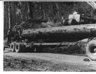 Kiewa Valley Historical Society
Photograph, logging at McKay Creek, Logging at McKay Creek, 1949/50
This photo was most likely taken at the site of the proposed McKay Creek Power Station. Excavation of this site was commenced in 1951 but an access road (a rough, narrow track) was put it in 1948 and widened in 1954. The State Electricity Commission would have milled logs from this area at their mill at Howman's Gap. The timber was used for building of housing and camps and provided a much needed resource as there was a general shortage of this commodity. The power station was relocated underground owing to repeated problems with landslides in the area. Restricted financial resources and the repositioning of the power station retarded construction activities and it was not completed until early 1961. An historical pictorial record of the type of machinery used in the 1950's - logging truck with bogie attached, the bull dozer and winch for hauling logs to the truck and note the lack of protective clothing!Black and white photograph showing a logging truck, bogie and bull dozer with winch for hauling the logs to the truck. Two men are on the truck, a driver on the bull dozer and a large log on the bogie. Hand written on the back of photo "Logging at McKay Creek".logging, mckay creek, timber, machinery -
 Eltham District Historical Society Inc
Photograph, Entrance to Shire of Eltham Memorial Park, Garden Hill, Eltham-Yarra Glen Road, Kangaroo Ground, c.1923
View to south-east from Shire of Eltham Soldiers' Memorial Park showing the carriageway from the road to top of Memorial Park. Accompanying notes state that the entry gate was put in place in May 1921. Eltham and Whittlesea Shire Advertiser and Diamond Creek Valley Advocate Fri 21 May 1920 p 2 reported: Kangaroo Ground Memorial Park "It was decided to arrange for a working bee on Saturday, 29th inst., for the purpose of forming and gravelling the track leading to the Park, and of carrying out other necessary works." A history summary of the Shire of Eltham Soldiers’ Memorial Park • The summit at Garden Hill was a popular tourist lookout and picnic spot from the 1880s. Virtually the entire Shire of Eltham and beyond could be viewed from this location. • A local farmer, Mr Walter A. D. Wippell is credited as being the first to propose the idea of a war memorial park and offered £50 towards the purchase of the land. • The earliest public reference to this project is to be found in the local Advertiser newspaper edition of August 9th, 1918. A report of the August Council meeting records the Eltham Shire President, Cr. Robert White, saying: "some time back it was proposed that the Council obtain and place on an Honour Board in the Council Chamber [at Kangaroo Ground] containing names of the lads who had enlisted. Just recently however, it had been suggested that a more fitting memorial would be the obtaining of a piece of land on the summit of Garden Hill, Kangaroo Ground, and the formation of a memorial park in which a monument could be erected to represent the whole of Shire. If a couple of acres could be obtained a gentleman had promised to donate 50 pounds, and another one would fence it, and other contributions, he was sure, could be obtained." • Councillors were favourable of the proposal and the President, Shire Secretary and Shire Engineer were deputised to wait on Messrs Mess Bros. (the owners of the Garden Hill farm) and ascertain if they would gratuitously give the land. The Mess Bros. land adjoined the farm/stud of Mrs Fanny White (Cr Robert White’s mother), daughter of Andrew Harkness who established their property on Garden Hill around 1846. • Access to the land came in February 1919 when several Councillors and the Shire Engineer surveyed the actual two acres of '5 chains along the road and 4 chains deep'. The Engineer volunteered his services free to do this task. The Mess brothers however demanded £100 per acre but eventually agreed to take £50 per acre. • Entry from the Kangaroo Ground-Yarra Glen road was seen to be a problem and Mrs. White, who owned the land beside the park, was asked to donated a triangle of her property to allow this access. • By September 1919 returned soldiers were employed by the Shire and volunteers were called to clear the hilltop by ploughing up the rocks and clearing the area, the fencing was put into place and in May 1921 the Council erected three gates, within an archway, at the entrance to the drive and pathway to the summit. • Public subscriptions were sought through the Advertiser newspaper to beautify the site. The views of the Curator of the Melbourne Botanical Gardens were sought as to the ‘class of ornamental trees most suitable for planting in the Park area”. • The Memorial Park or Shire of Eltham Soldiers’ Memorial Park was officially opened by Mr. W.H. Everard, M.L.A., 3 September 1921. • In 1922 plans were made to place a War Memorial in the Park. Funds were donated by the Council of £250 and a challenge to the community, to match this money with contributions was met. • On Anzac Day 1923, 1,000 people gathered on the summit in the park for a memorial service. A much smaller group of about 50 people gathered around a newly constructed cairn and flagstaff in the afternoon of Anzac Day 1924 amidst rain and a squally southerly wind, the morning service being cancelled. • A meeting for those interested in establishing a War Memorial monument within the park was held in January 1924 and the Eltham Shire War Memorial League was formed and a design competition decided upon. • The Shire of Eltham War Memorial tower was built in 1926 at a cost of £1,023 and 5 shillings with locally quarried stone donated by Dr Ethel and Professor William Osborne. It was formally known as the ‘Shire of Eltham War Memorial’ and was unveiled on 11 November 1926. The large bronze inscription above the entrance to the tower states: SHIRE OF ELTHAM WAR MEMORIAL THESE MEN DIED FOR THEIR COUNTRY 1914 IN REMEMBRANCE THIS TOWER WAS BUILT 1918 • The Caretaker’s hut was built in 1927 with left over from the tower construction. • A returned soldier was appointed to act as caretaker for the memorials. Tiny Carrol, a huge man, was the first caretaker and lived in the stone hut. There was a push to have alterations made at one stage to provide additional rooms for a married caretaker but was rejected. • A new Caretaker Cottage was built in 1951 at a cost £2,500. The cottage had been subjected to raids by thieves three times during construction until a guard from the Returned Servicemen’s League was posted until its opening. • The War Memorial tower was re-dedicated by Sir Dallas Brooks on 8 November 1951, unveiling new bronze plaques containing the names of those who fell during the Second World War. Sir Dallas also officiated the opening of the new Caretaker’s Cottage. • A toilet block was built in 1965. • A further dedication of the Shire of Eltham War Memorial tower took place 11 November 2001 to recognise the men who fell in subsequent campaigns up to and including Vietnam. • Four land titles are involved: o The purchase of the two acres from owners Ruth Gosling, Alexander Mess, James Johnson Mess and Joseph Mess is recorded in two actions, the first being the payment of £100 for the two acres, the second showing that the Shire of Eltham did not get a transfer of title until 14th January 1952. o The access land donated by Mrs. Fanny White is dated 26 February 1924. A further need to widen the entry came after the deepening of the road cutting and another land donation was given by Sir Herbert Gepp, title dated 15th May 1952. This would have been about the time he sold off the former White ‘Garden Hill’ property. o The land reserve to increase the area and possibly allow a circuit road to be put in place on the western side of the park was purchased by the Shire of Eltham, title dated 16th February 1973. Rare photograph of the entrance to the Shire's Memorial Park during early stages of development prior to the erection of the Shire of Eltham War MemorialSepia photograph printed with white border with slight crack lower left hand corner and three significant vertical cracks fanning from lower centre edge to upper edge Digitally enhanced version to minimise impact of crackseltham-yarra glen road, entrance gate, garden hill, kangaroo ground, shire of eltham memorial park, shire of eltham war memorial, kangaroo ground war memorial park -
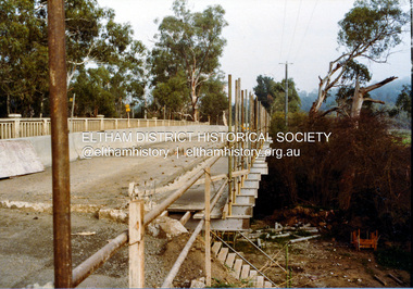
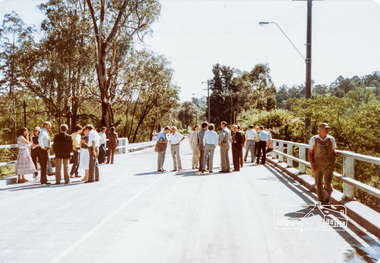
 Eltham District Historical Society Inc
Photograph, Ruth H. Pendavingh, Reconstruction of Main Road from Main Road Bridge to Mount Pleasant Road, Eltham, 1984
... . The bridge decking was widened along with Main Road to Dalton Street... in October 1926. The bridge decking was widened along with Main Road ...The original timber bridge over the Diamond Creek was built around 1840. It was destroyed by floodwaters in October 1923. A temporary bridge was rigged up but further damaged in April 1924. A new concrete bridge was built and opened in October 1926. The bridge decking was widened along with Main Road to Dalton Street by the Road Construction Authority in 1984. The upgraded bridge was re-opened October 25, 1984, 78 years after its original opening. (EDHS Chronology of known local events 1835- early 2000)Three colour photograph prints 1984, bridge construction, diamond creek (creek), eltham south, main road, main road bridge, road construction -
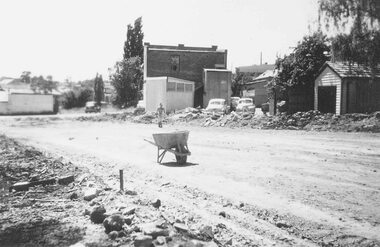
 Eltham District Historical Society Inc
Photograph, Hugh Fisher, Construction of dual road, Main Road, Eltham
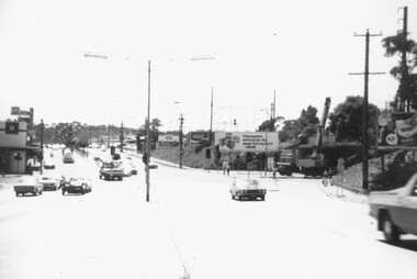
Black and white photograph of road construction equipment used in the widening and lane duplication of Main Road, Eltham looking north from near York Street, the old Shire of Eltham offices visible in the distance on leftA1234eltham, main road, construction -
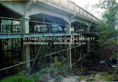
 Eltham District Historical Society Inc
Photograph, Main Road Bridge Over Diamond Creek, Eltham, 26/10/84
Two colour photographs of Main Road Bridge over the Diamond Creek, Eltham: A. view from walkway below bridge B. Friday 26th October 1984, official opening of bridge after widening looking from Eltham towards Greensborough near Antoinette Streetbridges, main road, diamond creek, eltham, eltham south -
 Eltham District Historical Society Inc
Negative - Photograph, Warrandyte Bridge over River Yarra, c.1910
View of the 1875 timber trestle bridge over the Yarra River reproduced from a newsprint image. Also known as Anderson's Creek (Road) Bridge A contract was accepted for William Elliot to erect a bridge over the Yarra River at Warrandyte on Anderson's Creek Road and other improvements for £1,331.6.2 - Gazette No. 143. Tuesday, November 13th 1860 - http://gazette.slv.vic.gov.au/view.cgi?year=1860&class=general&page_num=2161&state=V&classNum=G143&id=). The bridge was washed away by floods in 1863. It was replaced with a taller timber trestle structure in October 1875, designed and built by C.S. Wingrove, Shire Clerk, Engineer and Surveyor for Eltham Shire Council. A replacement for this bridge was commenced in 1955 to cope with increasing traffic and this structure was widened in 2018 to meet further traffic demands. Argus (Melbourne, Vic. : 1848 - 1957), Thursday 23 September 1875, page 7 ________________________________________ THE WARRANDYTE BRIDGE. The ceremony of formally opening the newly erected bridge over the Yarra at Ander-son's Creek was performed on Monday last, in the presence of the members of the Eltham and Bulleen shire councils whose territories it joins, and a goodly number of the residents of the district. The task was delegated to Mr. Cameron, M.L.A., who, after a few introductory remarks declared the bridge to be opened, and christened it the " Warrandyte Bridge." The party then adjourned to Grant's Hotel, where a cold collation had been prepared. The chair was taken by the president of the Eltham shire (Mr. John Bell) and the vice chair by Mr. Kent, a member of the Bulleen council. Mr Robert Williamson proposed "Success to the bridge," coupling with it the name of Mr. Cameron, to whose exertions was in the main to be attributed the erection of that structure which was an ornament to the district and would prove of great service to both sides of the river. Mr. Cameron, in responding, alluded to the great difficulties, mainly of a pecuniary nature, that had been encountered in carrying out the project, and which had only been got over by their united efforts and by the liberal spirit in which the late Commissioner of Roads had dealt with the case. The healths of the contractor and the engineer were also drunk. The bridge is a trussed timber one, resting on yellow box piles sunk into the solid rock, each pier being weighted with 50 tons of stone. The abutments consist of dry stone walls, 6ft. thick at the base, and tapering to 3ft. on the top, the face of the work having a batter of 1 to 1. The length of the bridge is 308ft., there being four openings in the centre of 66ft. each, and two at the ends of 20ft. each. The width in the clear is 9½ft., and the height from the bed of the river about 33ft. The approaches comprise 1,100 cubic yards of earthwork, and the formation of 48 chains of sideling, the whole cost of the work, which was carried out under the direction of the engineer to the Eltham Shire Council, being £1,413.This photo forms part of a collection of photographs gathered by the Shire of Eltham for their centenary project book,"Pioneers and Painters: 100 years of the Shire of Eltham" by Alan Marshall (1971). The collection of over 500 images is held in partnership between Eltham District Historical Society and Yarra Plenty Regional Library (Eltham Library) and is now formally known as the 'The Shire of Eltham Pioneers Photograph Collection.' It is significant in being the first community sourced collection representing the places and people of the Shire's first one hundred years.Digital image 4 x 5 inch B&W Neg B&W Print 12.5 x 9 cmsepp, shire of eltham pioneers photograph collection, warrandyte, bridge -
 Ringwood and District Historical Society
Photograph, Lane from Adelaide St Ringwood (widening) and Jack Orr's shed 1958
Written next to photographs (mounted on single sheet of paper): SS0182a: "Lane from Adelaide Street to Melbourne Street being widened to form street." SS0182b: "Shed on left used by Jack Orr for making steel cloths hoists. Nov. 1958" -
 Ringwood and District Historical Society
Memorabilia, Packet: Ladies Probus Club of Ringwood Inc- 10 year booklet, Heathmont Ladies Probus Club newsletters 1990-1993
Heathmont Ladies Probus 3 newsletters 1990 to 1993; Ringwood Ladies Probus 10 year booklet "Ever Widening Circles"Packet includes: . Ladies Probus Club of Ringwood Inc. 10 year booklet- "Ever Widening Circles". . Newspaper clipping. . Heathmont Ladies Probus Club, 3 newsletters 1990 to 1993. -
 Ringwood and District Historical Society
Photograph, Widening of railway bridge on Warrandyte Rd, Ringwood 1977
Catalogue card reads, "Widening of railway bridge on Warrandyte Rd.". 1977 -
 Ringwood and District Historical Society
Photograph, Maroondah Highway West, Ringwood, 1965. Wantirna Road bridge
Written on back of photograph, "Wantirna Road railway bridge. Preparing to widen underpass - 1965". -
 Flagstaff Hill Maritime Museum and Village
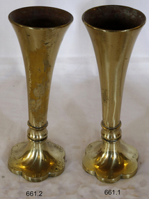
Vase
Vases (2) heavy brass with floral designed base, narrow stem widening to larger top.flagstaff hill, warrnambool, shipwrecked-coast, flagstaff-hill, flagstaff-hill-maritime-museum, maritime-museum, shipwreck-coast, flagstaff-hill-maritime-village, vase -
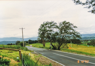
 Eltham District Historical Society Inc
Photograph, Widened road reserve, Henley Road, Kangaroo Ground, 6 December 1992, 06/12/1992
... henley road Colour photograph Widened road reserve, Henley Road ...The Eltham Horse Trail: Research and Warrandyte to Kinglake: Survey of proposed route, December 1992: (2) Warrandyte to Kangaroo GroundColour photographeltham horse trail (1992 survey), kangaroo ground, henley road -
 Eltham District Historical Society Inc
Photograph, Widened road reserve near Memorial Tower, Eltham-Yarra Glen Road, Kangaroo Ground, 6 December 1992, 06/12/1992
... Widened road reserve near Memorial Tower, Eltham-Yarra Glen Road ...The Eltham Horse Trail: Research and Warrandyte to Kinglake: Survey of proposed route, December 1992: (2) Warrandyte to Kangaroo GroundColour photographeltham horse trail (1992 survey), kangaroo ground, eltham-yarra glen road, war memorial tower -
 Eltham District Historical Society Inc
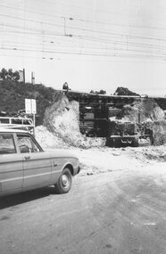
Negative - Photograph, Russell Yeoman, Para Road / Carter Street Bridge over the Plenty River, Briar Hill, c.Jul. 1969
Bridge over the Plenty River at Briar Hill before widening and alterations. The Plenty River at Briar Hill represented the boundary between the Shire of Eltham and the Shire of Diamond Valley. The bridge was known as the Carter Street Bridge as prior to 1969 Para Road, Briar Hill became Carter Street, Greensborough across the river. It was at this time that the name Para Road was continued and replaced Carter Street.This photo forms part of a collection of photographs gathered by the Shire of Eltham for their centenary project book,"Pioneers and Painters: 100 years of the Shire of Eltham" by Alan Marshall (1971). The collection of over 500 images is held in partnership between Eltham District Historical Society and Yarra Plenty Regional Library (Eltham Library) and is now formally known as the 'The Shire of Eltham Pioneers Photograph Collection.' It is significant in being the first community sourced collection representing the places and people of the Shire's first one hundred years.Digital image 35 mm B&W negativeshire of eltham pioneers photograph collection, briar hill, 1969-07, bridge, carter street bridge, para road, para road bridge, plenty river, shire of diamond valley, shire of eltham -
 Glen Eira Historical Society
Album - Album page, Normanby Road, Circa 1972
... ) - Vol 2 by Andrew Ward and Associates The widening of Dandenong...) - Vol 2 by Andrew Ward and Associates The widening of Dandenong ...This photograph is part of the Caulfield Historical Album 1972. This album was created in approximately 1972 as part of a project by the Caulfield Historical Society to assist in identifying buildings worthy of preservation. The album is related to a Survey the Caulfield Historical Society developed in collaboration with the National Trust of Australia (Victoria) and Caulfield City Council to identify historic buildings within the City of Caulfield that warranted the protection of a National Trust Classification. Principal photographer thought to be Trevor Hart, member of Caulfield Historical Society. Most photographs were taken between 1966-1972 with a small number of photographs being older and from unknown sources. All photographs are black and white except where stated, with 386 photographs over 198 pages. From: Glen Eira Heritage Management Plan (1996) - Vol 2 by Andrew Ward and Associates The widening of Dandenong Road during the late 1980's has resulted in the destruction of the houses in the path of the roadworks and the construction of a high fence serving as a visual barrier between that thoroughfare and the remaining houses. Where comparatively large villas once stood on spacious allotments, only "Wisteria" survives at No. 135 Normanby Road. Adopting forms and timber enrichment characteristic of the American Queen Anne style, it has this in common with the largely reconstructed timber villa at no. 11 Normanby Avenue and to a lesser extent, 746 Inkerman Road. Normanby Road retains its comparatively opulent Edwardian character in a mature landscaped setting with spacious gardens and mature planes parallel with the railway reserve which, on account of the low lying ground in its vicinity has a high embankment commencing on the alignment of Malvern Grove and continuing to Caulfield Station. The earliest villas are Edwardian. Page 148 of Photograph Album with one landscape photograph of a house on Normanby Road (not Street).Handwritten: Normanby St [top right] / 148 [bottom right]trevor hart, verandah, porch, bull nosed verandah, tower house, tower, stone fence, normanby road, wisteria, american queen anne style, queen anne style, 1890's, mayfield grove, normanby street, timber houses, caulfield north, house names, edwardian, edwardian style, gardens -
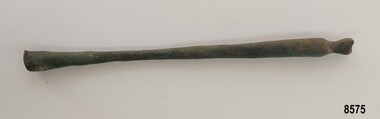 Flagstaff Hill Maritime Museum and Village
Functional object - Brass rod, Russell & Co, Circa 1886
In the 19th century, the Industrial Revolution meant that shipbuilders could build ships using iron. These iron ships could be much larger, with more space for cargo and they didn't need as much work to keep them in good condition. Isambard Kingdom Brunel's "Great Britain" built in 1843, was the first ship to be built entirely of wrought iron. In the 1880's steel began to be used instead of iron. Ships also began to be fitted with steam engines although a great deal of coal was needed to travel even short distances. For this reason, ships continued to be fitted out with sails even though some came with engines. The iron-hulled, four-masted barque, the Falls of Halladale, was a bulk carrier of general cargo. She left New York in August 1908 on her way to Melbourne and Sydney. In her hold, along with 56,763 tiles of unusual beautiful green American slates (roofing tiles), 5,673 coils of barbed wire, 600 stoves, 500 sewing machines, 6500 gallons of oil, 14400 gallons of benzene, and many other manufactured items, were 117 cases of crockery and glassware. Three months later and close to her destination, a navigational error caused the Falls of Halladale to be wrecked on a reef off the Peterborough headland at 3 am on the morning of the 15th of November, 1908. The captain and 29 crew members all survived, but her valuable cargo was largely lost, despite two salvage attempts in 1908-09 and 1910. ABOUT THE ‘FALLS OF HALLADALE’ (1886 - 1908) Built: in1886 by Russell & Co., Greenock shipyards, River Clyde, Scotland, UK. The company was founded in 1870 (or 1873) as a partnership between Joseph Russell (1834-1917), Anderson Rodger and William Todd Lithgow. During the period 1882-92 Russell & Co., standardised designs, which sped up their building process so much that they were able to build 271 ships over that time. In 1886 they introduced a 3000 ton class of sailing vessel with auxiliary engines and brace halyard winches. In 1890 they broke the world output record. Owner: Falls Line, Wright, Breakenridge & Co, 111 Union Street, Glasgow, Scotland. Configuration: Four masted sailing ship; iron-hulled barque; iron masts, wire rigging, fore & aft lifting bridges. Size: Length 83.87m x Breadth 12.6m x Depth 7.23m, Gross tonnage 2085 ton Wrecked: the night of 14th November 1908, Curdies Inlet, Peterborough south west Victoria Crew: 29 The Falls of Halladale was a four-masted sailing ship built-in 1886 in Glasgow, Scotland, for the long-distance cargo trade and was mostly used for Pacific grain trade. She was owned by Wright, Breakenridge & Co of Glasgow and was one of several Falls Line ships, all of which were named after waterfalls in Scotland. The lines flag was of red, blue and white vertical stripes. The Falls of Halladale had a sturdy construction built to carry maximum cargo and able to maintain full sail in heavy gales, one of the last of the ‘windjammers’ that sailed the Trade Route. She and her sister ship, the Falls of Garry, were the first ships in the world to include fore and aft lifting bridges. Previous to this, heavily loaded vessels could have heavy seas break along the full length of the deck, causing serious injury or even death to those on deck. The new, raised catwalk-type decking allowed the crew to move above the deck stormy conditions. This idea is still used today on the most modern tankers and cargo vessels and has proved to be an important step forward in the safety of men at sea. On 4th August 1908, with new sails, 29 crew, and 2800 tons of cargo, the Falls of Halladale left New York, bound for Melbourne and Sydney via the Cape of Good Hope. The cargo on board was valued at £35,000 and included 56,763 tiles of American slate roofing tiles (roof slates), 5,673 coils of barbed wire, 600 stoves, 500 sewing machines, 6,500 gallons of oil, 14,400 gallons of benzene, plumbing iron, 117 cases of crockery and glassware and many other manufactured items. The Falls of Halladale had been at sail for 102 days when, at 3 am on the night of 14th November 1908, under full sail in calm seas with a six knots breeze behind and misleading fog along the coast, the great vessel rose upon an ocean swell and settled on top of a submerged reef near Peterborough on the south-west Victoria’s coast. The ship was jammed on the rocks and began filling with water. The crew launched the two lifeboats and all 29 crew landed safely on the beach over 4 miles away at the Bay of Islands. The postmistress at Peterborough, who kept a watch for vessels in distress, saw the stranding and sent out an alert to the local people. A rescue party went to the aid of the sailors and the Port Campbell rocket crew was dispatched, but the crew had all managed to reach shore safely by the time help arrived. The ship stayed in full sail on the rocky shelf for nearly two months, attracting hundreds of sightseers who watched her slowly disintegrate until the pounding seas and dynamiting by salvagers finally broke her back, and her remains disappeared back into deeper water. The valuable cargo was largely lost, despite two salvage attempts in 1908-09 and 1910. Further salvage operations were made from 1974-1986, during which time 22,000 slate tiles were recovered with the help of 14 oil drums to float them, plus personal artefacts, ship fittings, reams of paper and other items. The Court of Marine Inquiry in Melbourne ruled that the foundering of the ship was entirely due to Captain David Wood Thomson’s navigational error, not too technical failure of the Clyde-built ship. The shipwreck is a popular site for divers, about 300m offshore and in 3 – 15m of water. Some of the original cargo can be seen at the site, including pieces of roof slate and coils of barbed wire. This particular artefact was one of many found by John Laidlaw (a local Warrnambool diver) when diving on the Falls of Halladale in the 1960's. In August 1973, John Laidlaw and Stan McPhee went on to discover the underwater location of the Schomberg - a passenger ship that ran aground on December 26th 1855 near Peterborough which now lies in 825 metres of water. When John Laidlaw died, his family donated a number of artefacts to Flagstaff Hill.This item is significant as it was recovered by a local diver from the Falls of Halladale. The Falls of Halladale shipwreck is listed on the Victorian Heritage Register (No. S255). She was one of the last ships to sail the Trade Routes. She is one of the first vessels to have fore and aft lifting bridges. She is an example of the remains of an International Cargo Ship and also represents aspects of Victoria’s shipping industry. The wreck is protected as a Historic Shipwreck under the Commonwealth Historic Shipwrecks Act (1976).Long, slender, smooth brass rod tapering from 1.5 cm diameter at one end to .8 cm and widening back out to 1.5 cm at opposite end. One end has a smooth, rounded edge and the other end curves in and out with the end showing evidence of a piece having been broken off.flagstaff hill, flagstaff hill maritime museum and village, flagstaff hill divers, great ocean road, shipwreck coast, warrnambool, falls of halladale, falls of halladale wreck, shipwreck artefact, artefact, brass artefact, brass rod, brass fitting, diver, john laidlaw -
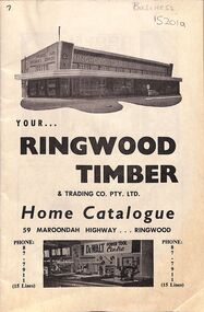 Ringwood and District Historical Society
Pamphlet, Two catalogues from Ringwood Timber & Trading circa 1960s
Two catalogues of goods to sell, from Ringwood Timber & TradingEditorial of 15201b includes a short history of the company. In 1937, Mr S Coopersmith and son, Frank (the present Managing Director) started a fruit case manufacturing business in North Melbourne under the name of The Cooper Case Co. The business flourished, and in 1940, recognising the possibilities in and around Ringwood, an old bush sawmill and an area of land on the Maroondah Highway, were secured. Subsequent purchases have since increased this area to approximately 15 acres. It was decided to widen the activities and scope of the business and two new firms were formed. Cooper Sawmilling Co., which operated a modern sawmill, and Ringwood Timber & Trading Co., which handled the output of the sawmill and introduced builders' and general hardware lines to meet the demands of this rapidly expanding area. As Ringwood grew, so too did the organisation which was created to serve it. The principals studied timber and hardware merchandising trends overseas, and after considerable investigation the new building on Maroondah Highway was completed in 1956. Today, acclaimed as one of the most modern mills and hardware stores in the Southern Hemisphere, combining up to date machinery and handling equipment together with unique drive-in facilities and a self-selection centre. Ringwood Timber & Trading Co. are proud to offer a service unparallelled to home builders. In conformity with modern commercial practice the various firms have since been incorporated under the Victorian Companies Act and the latest accounting methods and office equipment have been installed to provide an efficient and virile administration to control the entire manufacturing and trading activities. We have a staff of over 220 personnel, each trained in their particular field to provide you, our valued client, with expert advice, quality merchandise and second-to-none service to enable you to fulfil every need in and around your home. -
 Ringwood and District Historical Society
Newspaper, Scrapbook Clipping, Library Collection, Ringwood, Victoria
Newspaper Clipping from "The Mail", 6 April 1993, Page11, "Rate hardship to be reviewed"'. Article written by Janine JonesRingwood Council will review its hardship provisions for waivering unpaid rates. Mayor Greg Adkins said he was concerned that no ratepayers had their $100 state defecit tax levy waivered due to hardship as part of the latest round of rate changes. This was surprising when there was much hardship in the community. Cr Margaret Cheevers said the loosening of hardship provisions should be widened to apply to those who had difficulty paying their rates. Council's Chief Executive, John Paech , said only a "handful" of ratepayers had applied for hardship provisions -
 Port Melbourne Historical & Preservation Society
Photograph - Footpath widening Bay Street between Liardet and Pool Streets, Port Melbourne, Ron Laing, 2000
Part of Ron Laing's collection of photographs recording Port Melbourne over a thirteen year period. Donated to the PMH&PS by the photographer.A set of six colour photographs showing the reconstruction work under way on the extra width footpaths in Bay Street between Liardet and Pool Streetsengineering - roads streets lanes and footpaths, built environment, ron laing -
 St Kilda Historical Society
Photograph, c. 1973
High Street St Kilda was widened in 1973 and renamed St Kilda Road. The shops and houses on the south side of the road were demolished to allow for the construction of a multiple lane highway.colour photographst kilda, high street, -
 Hume City Civic Collection
Photograph, c 1980s
The stone bridge was the only entry into Sunbury on the eastern side of the town and was in use until the road was re-routed and widened in the 1970s.A coloured photograph of the roadway over the Macedon Street bridge which spans Jacksons Creek. There is a grassy area in the foreground with trees growing either side of the bridge. The narrow asphalted surface of the road across the bridge is cut off by a low stone wall.stone bridges, jacksons creek, macedon street road bridge, george evans collection -
Stawell Historical Society Inc
Archive - Document, Specification Documents Stawell hospital, 1933- 1980
... of Parking areas and Widening Existing Accress Road. April 1979 - 19... of Parking areas and Widening Existing Accress Road. April 1979 - 19 ...1933 - 1980 -1 Specifications New Hospital - 2 Specification of Excavation and Leveling. Febuary 1933 - 3 Specification of Enterane roadway. November 1933 - 4 Specifications Alterations and Additions. June 1940 - 5 Specification Repairs and External Painting - June 1940. Plus some tender application Letters - 6 Specifactions New Brick and Timber Linen Store. January 1943 - 7 New Nursing Home Construction - Bills of Quantities and Estimates August 1954 - 8 Specifactions for Building nurses Home - 9 Specifactions New work Alterationsto service Rooms. April 1955 - 10 Specifactions Nurses Home ( Timber Balustrades & Brick Retaining wall.) June 1956 - 11 Specifactions Labour and Materials Erecetion and Completion of Additions to Matron's Flat. August 1964 - 12 Specifactions of Work to be done and Materials to be use din Remodelling and Additions. October 1965. - 13 Specifaction for Supply & Installation of Hot Water, Heating & Air Conditioning Plant New Theatre Wing. November 1965 - 14 Specifaction of Remodelling and Additions at Stawell. New Geriatric Ward. November 1971 - 15 Specifactions of Electical Services at New Geriatric Ward November 1971 - 16 Specifaction for building works for Geriatric Day Centre Wing c1975 - 17 Specification Geriatric Day Centre Electrical Service. March 1975 - 18 Plans and Specifications for construction of Parking areas and Widening Existing Accress Road. April 1979 - 19 Specifications of Electrical Services for Lighting installations. January 1980 PLANS - 20 Male barthroom. July 1964 - 21 Additions to Matrons Flat - 22 Alteration Sketch Plan. June 1962 - 23 Approach to Sloane Street. September 1933 - 24 Hobart Food Services AM12 Series Washer pamphlet. - 25 Hospital Appeal Correspondance. October 1963.hospital -
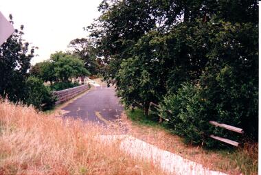
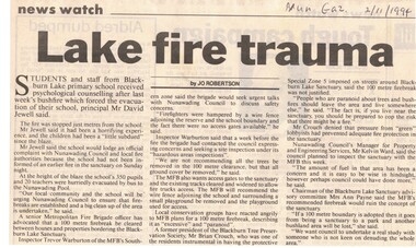 Whitehorse Historical Society Inc.
Article, Lake fire trauma, 2/11/1994 12:00:00 AM
2 November 1994 following the fire at Blackburn Lake . Melbourne Fire Brigade want access gates to the sanctuary and existing tracks cleared and widened to allow fire trucks access.Article in Nunawading Gazette 2 November 1994 following the fire at Blackburn Lake which burnt up to 100 metres of Blackburn Lake Primary School. Melbourne Fire Brigade want access gates to the sanctuary and existing tracks cleared and widened to allow fire trucks access. Also 150 metre fire break around the school was recommended but the chairman of the Blackburn Lake Advisory Committee thought having a fire break would ruin the concept of the sanctuary. 2 November 1994 following the fire at Blackburn Lake . Melbourne Fire Brigade want access gates to the sanctuary and existing tracks cleared and widened to allow fire trucks access. bushfires, blackburn lake primary school no 4860, jewell, david, city of nunawading, melbourne fire brigade, blackburn and district tree preservation society, blackburn lake sanctuary advisory committee, payne, ann -
 Whitehorse Historical Society Inc.
Tool - Leatherwork Tools
Wooden block of wood with five semi-circular recessions graduated in size. Also four elongated wooden rods with round handle at top and a round shaped bottom approximately matching the holes in the block. Further wooden rod with elongated neck widening at the top with hole in top and a small pointed wooden rod with a round top. A total of 8 pieces in the set. Used for decorating leather. See sample in NA2849handcrafts, leatherworking, trades