Showing 166 items matching "school 60"
-
 Bendigo Historical Society Inc.
Document - Hustlers, Sheepshead and Deborah lines of reef
Albert Richardson was a mining historian who wrote widely on the mines of the Bendigo Goldfield. The park opposite the Goldmines Hotel in Marong Road, is named in his honour. Five page document, hand written by Albert Richardson on lined foolscap and edited with cross-outs and insertions, . The mines along the Hustlers line of reef and the Sheepshead line of reef are described. Mines listed on Hustlers line of reef: Fortuna Hustlers (1888 - 1913), shaft 2,240 feet at rear of Buckell and Jeffrey's offices; Royal Hustlers Reserve No. 2 - two shafts 'City" 860 feet, now covered by R.S.L. building Pall Mall, steel poppet legs 60 ft high and 'Park Shaft" at rear of Camp Hill School, 1,775 feet, steel poppet legs 60 feet high; Hustlers Hill Group first worked by Jonathan Harris in 1853 and bounded by Valentine, Anderson and Ironbark Creek to the north and Milroy Street to the east, one of first areas worked for quartz reefing. It with Garden Gully line west and Victoria Hill Ironbark, formed by far the richest cross section of the Bendigo Goldfield. Great Extended Hustlers (1865-1921) close to intersection of Anderson Street and Hustlers Road, mullock heap against road and shored up around shaft, steel poppet legs now at Wattle Gully mine, Chewton, large winding machine, air compressor south of shaft and 36 head crushing battery. Hustlers Reef (Old Hustlers) and Hustlers Reef No. 1, two shafts, main 2,210 feet, about 220 yards east of Moran Street and against Fenton Street. , No. 1 shaft 1,140 feet and about 155 yards east of Moran Street. Lansell's Comet, Lightining Hill line, 2.100 feet, on Comet Hill approx 70 yards west of Holmes Road, near Comet Creek, steel poppet legs. United Hustlers and Redan (1876-1918), main Redan, 1,830 feet about 155 yards west of Sandhurst Roead, in line with Comet Hill State School, this hill known as Redan Hill. North, or New Hustlers, once known as Agnew Hustlers, wooden poppet legs, south side, Kneebone Street, Eaglehawk. Derby line, Johnson's No. 3, South Johnson's (east shaft of Collman and Tacchi) 439 feet on west wide of Woods Street, south of Wetherall Street. Paddy's Gully Line, south to north, some shafts - Lansell's 'Sandhurst" ('Needle") Eaglehawk Road shaft 2,425 feet, about 50 yards east of Needle Loops, a brick square sided chimney with Cleopatra Needle top. British American, 789 feet, just south of Holdsworth Road. Collman and Tacchi, main shaft 2,588 feet, 60 yards west of Eaglehawk Road, California Gully. Deborah Line of Reef, The Deborah (1932-1954) shaft 2.017 feet, west of Adams Road and south of Abel Street, Quarry Hill. North Deborah (1937 - 1954) shaft 1,151 feet, Breen Street, Quarry Hill, steel poppet legs. Central Deborah (1939-1954) shaft 1,347 feet Sheepshead line of reef, Lansell's South Red, White and Blue, shaft 2,124 feet, north east of Bellevue Road and 220 yards east of Adams Road. The New Red, White and Blue Consolidated (Big Blue) main shaft 2,416 feet. Lansell's Bendigo Battery 105 head, north of 'Big Blue" on his freehold lease, commenced crushing on 24th February 1895. After closing was erected as the Showground's Industrial Hall, July 1926. North Red, White and Blue, burnt down February 1926, new company 1934, closed 1938. Document is part of the Albert Richardson Collection of Bendigo mining history. bendigo, gold mining, deborah line of reef, sheepshead line of reef, hustlers line of reef, royal hustlers reserve mine, hustlers hill group of mines, great extended hustlers, hustlers reef no. 1, lightning hill line, old comet, collman and tacchi, lansell's comet, north deborah, central deborah, dhrrpdhrsf linr og trrg, new red, white and blue consolidated mine, big blue, lansell's bendigo battery, north red, white and blue mine, albert richardson collection -
 Linton and District Historical Society Inc
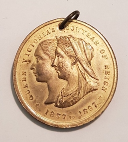
Medallion, Queen Victoria's Diamond Jubilee Celebrations, 1897
Queen Victoria's Diamond Jubilee was celebrated enthusiastically across the British Empire. Commemorative medallions were produced and distributed by the Victorian government and many local governments. Two medallions produced for this occasion by the Shire of Grenville are in the LDHS collection. One of these is believed to have been presented to schoolgirl Mabel Cluff, of Linton State School. The medallion which was presented to Mabel Cluff was donated to LDHS in 1995. Acquisition of this medallion is acknowledged in "Society Notes", Number 118, July 1995, but donor's name is not recorded. For reasons unknown these two medallions were not catalogued until 2016.Round, gilt bronze medallion, on the obverse two conjoined faces of Queen Victoria, one as a young girl, the other as an older woman. The phrase "Queen Victoria 60 Years of Reign" and the dates "1837-1897" around the perimeter. "Stokes and Sons" imprinted in tiny letters on the extreme lower edge. On the reverse, an image of the Shire of Grenville offices in Linton, with the word "Linton" underneath. "Shire of Grenville" & "Victoria" around the perimeter. Medallion has small metal loop through hole at top.queen victoria, medallions, diamond jubilee, shire of grenville, mabel cluff -
 Bacchus Marsh & District Historical Society
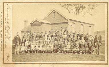
Photograph, Coimadai State School teachers and students 1883
Coimadai is a rural community located 10km north of Bacchus Marsh. The Coimadai School was opened in 1862. It was at first entirely funded by the local residents in the area. In these early years it was known as the Pyrete School after the nearby creek of that name. The building shown in this 1883 image was constructed in 1872 and replaced an earlier wooden structure. Over time the Coimadai School became a government funded and administered school. A famous pupil to attend the school was John Cain Senior, Premier of Victoria in the 1940s and 1950s, who attended the school for one year in 1893. This school still operates as a state primary school.Small sepia unframed photograph on card with gold border framing photograph. Housed in the album, 'Photographs of Bacchus Marsh and District in 1883 by Stevenson and McNicoll'. The image is a large group portrait of the pupils of the Coimadai State School and their two male teachers. There are about 60 pupils. The older children are standing in rows and a younger group of pupils is seated on forms or benches in front of them. One teacher stands on the right of the group of pupils and the other is on the left. The School building can be seen in the background.On the front: Stevenson & McNicoll. Photo. 108 Elizabeth St. Melbourne. COPIES CAN BE OBTAINED AT ANY TIME. On the back: LIGHT & TRUTH inscribed on a banner surmounted by a representation of the rising sun. Copies of this Portrait can be had at any time by sending the Name and Post Office Money Order or Stamps for the amount of order to STEVENSON & McNICOLL LATE BENSON & STEVENSON, Photographers. 108 Elizabeth Street, MELBOURNE schools, schools coimadai vic., stevenson and mcnicoll 1883 photographs of bacchus marsh and district -
 Clunes Museum
Photograph, JUBILEE OF PRESBYTERIAN CHURCH, 1922
... JUBILEE OF PRESBYTERIAN CHURCH 60 YEARS OF SUNDAY SCHOOL... JUBILEE OF PRESBYTERIAN CHURCH 60 YEARS OF SUNDAY SCHOOL OCT. 1922 ...JUBILEE OF CLUNES PRESBYTERIAN SUNDAY SCHOOL OCTOBER 1922.PHOTOGRAPH, BLACK AND WHITE, GROUP OF ADULTS AND CHILDREN AT JUBILEE OF PRESBYTERIAN CHURCH IN 1922.JUBILEE OF PRESBYTERIAN CHURCH 60 YEARS OF SUNDAY SCHOOL OCT. 1922local history, photography, photographs, churches presbyterian -
 Melbourne Tram Museum
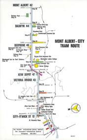
Map, Melbourne & Metropolitan Tramways Board (MMTB), Set of 15 tram route maps, 1977 to 1979
Series of 15 colour route maps for various tram lines or groups of tram lines for the MMTB. Some have the Transport Information Centre telephone printed on them, others have a label stuck on. Some are finished with a plastic laminate finish on either one or both sides. Show the major cross streets, parks, schools, other tram routes, major stop numbers and railway lines. Two copies of each held unless noted otherwise. .1 - Mont - Albert City - R11/77, shows routes 43. 47. 45. 44 .2 - Malvern, East Malvern, Carnegie and East Brighton Tram Routes (from St Kilda Junction) - R1/79 - shows routes 5, 3, 67, 66, 61, 62 and 64. .3 - Swanston St tram guide - R1/79 - lists all routes and route numbers that branch or cross Swanston St between Grattan St and St Kilda Junction. .4 - St Kilda Rd Tram Routes R12/77 - details South Melbourne Beach, route 1 and route 2 and St Kilda Beach routes 15, 16 and 55 otherwise shows were the various routes branch off St Kilda Road. Copy 1 has "P14909" in pencil in the bottom right hand corner. .5 - Kew - St Kilda Beach - R1/79 - Route 69. .6 - Footscray - Moonee Ponds - R3/81 - Route 82 .7 - Flinders St tram routes - R5/78 - North Balwyn, East Burwood, routes 48, 40, 41, Hartwell, 28, 74 and 75 .8 - William St tram routes - Route 55, 56 and 63 - South Melbourne Depot and Domain. copy 2 has "P14913" in bottom right hand corner. .9 - Toorak Camberwell and Glen Iris tram routes with Camberwell Junction and Malvern Town Hall, R1/79, routes 8, 7, 6, 72 and 73 shown. .10 - Swanston St tram routes - R12/77 - shows all the Swanston St routes, including East Coburg and Moreland. .11 - Bourke St tram routes - R4/77 - East Brunswick Blyth St and East Preston Tyler St and intermediate routes, routes 95, 96, 97, 90, 89 and 88. .12 - as for .11, dated 1/85, showing extension to La Trobe University - has Metropolitan Transit logo. Only 1 copy held. Also shows route 92 and 87. .13 - Batman Ave tram routes - R9/77 - Wattle Park, North Richmond and Prahran - routes 70, 71, 78 and 79. .14 - City route guide - R9/77 - showing all route numbers and destinations that passed through the CBD. .15 - Elizabeth St tram routes - R12/77 - Essendon Airport, West Maribyrnong, North Coburg lines, routes 50, 58, 60, 54, 57, 52. 49, 59, 18, 20 and 19. Copy 1 has "P14905" in pencil in bottom left hand corner.trams, tramways, maps, route guide, route numbers, routes, mont albert, route 43, route 47, route 45, route 44, route 42, malvern burke rd, east preston, carnegie, east brighton, south caulfield, route 5, route 3, route 67, route 62, route 64, route 66, glenhuntly tram depot, swanston st, st kilda rd, south melbourne beach, st kilda beach, route 1, route 2, route 15, route 16, route 55, kew- cotham road, route 69, route 79, route 82, footscray, moonee ponds, flinders st, north balwyn, kew, east burwood, burwood, hartwell, richmond, route 48, route 40, route 41, route 28, route 74, route 75, route 56, route 63, william st, west coburg, toorak, camberwell, glen iris, malvern town hall, route 72, route 73, route 7, route 8, bourke st, route 6, route 95, route 96, route 97, route 90, route 89, route 89, east preston, east brunswick, la trobe university, clifton hill, route 92, route 87, route 70, route 71, route 78, route 79, north richmond, prahran, wattle park, essendon airport, west maribyrnong, north coburg, route 50, route 58, route 60, route 54, route 57, route 52, route 49, route 59, route 18, route 20, route 19, batman ave -
 Whitehorse Historical Society Inc.
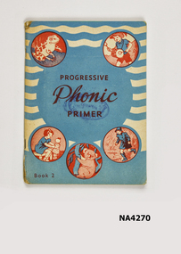
Book, Progressive Phonic Primer
Delisted from Blackburn East Library State School c 1970'sProgressive Phonic Primer. Book 2. Blue/red/brown/white cover with illustrations of various stories in book. 60 pages. Card cover, paper inserts with text.State School Blackburn East 4800 Stamp.school, equipment -
 Ringwood and District Historical Society
Document - Research Notes, Richard Carter, Land Subdivisions in Ringwood 1890-1950
Handwritten table listing main local pre-1950s subdivisions in the Ringwood area, with estate names, streets, number of allotments for sale, and where known, vendor agent, LP (Lodged Plan) title registration number, and auction/sale date, some with sale price.Pg1 RINGWOOD STATION ESTATE LP3070 (Year?) Station Street, William Street (now Kendall Street), Wantirna Road, Station Street Pg1 RINGWOOD TOWNSHIP ESTATE LP5577 (1913) Station Road (now Warrandyte Road), Pratt Street (part now Aird Street), Whitehorse Road Pg2 RINGWOOD ORCHARD ESTATE LP4315 (1914) Brysons Road, Hillcrest Road, Anzac Avenue, Sulva Road Pg3 RINGWOOD RAILWAY ESTATE LP7522 (1918) Whitehorse Road (now Mount Dandenong Road), Dublin Road, Freeman Street, Patterson Street, Bona Street Pg4 THE RINGWOOD ESTATE LP7578 (1919) Warrandyte Road, Hobart Street, Paxton Street, Arnold Street Pg5 GARDEN FARMS ESTATE (LP?) (1919) Canterbury Road, Armstrong Road, Bungalook Road, Orchard Road, Bayswater Road (now Mountain Highway) Pg6 THE RINGWOOD ESTATE (SECOND SUB-DIVISION) LP7604 (1919) Warrandyte Road, Tamar Street, Derwent Street, Mersey Street Pg7 RINGWOOD STATION ESTATE LP7703 (1919) Bedford Road, Williams Grove (now Lena Grove) Pg8 RINGWOOD TOWNSHIP ESTATE LP8198 (1919) Wantirna Road, Ellison Street, Haig Street, Greenwood Avenue Pg9 EASTFIELD ESTATE (LP?) (1920) Eastfield Road, Longview Road, Pleasant Rise, The Mount Pg10 ELECTRIC RAILWAY ESTATE RINGWOOD LP9473 (1922) Campbell Street, Myrtle Avenue, George Street (now Tudor Court), Henry Street (now Myrtle Avenue), Williams Grove (now Lena Grove) Pg11 RINGWOOD PARK ESTATE LP7884 (1922 - two stages) Wonga Road (now Loughnan Road), William Street, Andrew Street, Harrison Street Pg12 HEATHMONT STATION ESTATE LP11009 (Date? - after 1922) Lisgoold Street, Viviani Crescent, Balrour Avenue, Station Street (now part Heathmont Road and part Wainui Street) Pg13 RINGWOOD RAILWAY ESTATE LP10507 (1923) Whitehorse Road, Sherbrooke Avenue, Burwood Avenue, Bonview Avenue, Heatherbrae Avenue, Grant Crescent Pg14 GARDEN HOMES ESTATE (LP?) (1923) Mullum Road, The Centreway, Wattle Crescent (now Wattle Avenue) Reserve Crescent (now Reserve Road) Pg15 DUBLIN ROAD ESTATE LP11993 (1923) Alexandra Road, Vonadawn Avenue, Green Street, Wood Street, Howard Avenue, Bedford Road, Dublin Road Pg16 CARLINGA ESTATE RINGWOOD LP9620 (1923) Bourke Street, Bond Street, Ringwood Street Pg17 PRATT'S JUNCTION ESTATE (LP?) (1923) Junction Street, Georges Road, Oliver Street, Whitehorse Road Pg18 EAST RINGWOOD ESTATE LP10492 (1923) Bona Street, Patterson Street, Miller Grove, Fairview Avenue, Eastfield Road, Whitehorse Road (now Mount Dandenong Road) Pg19 COLEMAN'S HEATHMONT ESTATE LP9974 (1923) Canterbury Road, Bedford Road, Alvena Crescent, Coleman Street, Leonard Street (now Royal Avenue) Pg20 RINGWOOD HEIGHTS ESTATE LP10506 (1924) Whitehorse Road, Bonview Avenue, Grant Crescent, Hillcrest Avenue, Heatherbrae Avenue, Margaret Street, Mary Street Pg21 EAST RINGWOOD STATION ESTATE LP10551 (1924) Knaith Road, Wenwood Street, Lois Street, Victoria Street, Station Street (now Railway Avenue) Pg22 GRAND VIEW ESTATE LP11019 (1924) Whitehorse Road, Rupert Street, Herbert Street, Leonard Street Pg23 RINGWOOD RAILWAY ESTATE & RINGWOOD HEIGHTS ESTATE - FINAL SECTIONS LP10506 & LP10507 (1924) Whitehorse Road, Sherbrooke Avenue, Burwood Avenue, Bonview Avenue, Heatherbrae Avenue, Margaret Street, Mary Street, Grant Crescent Pg24 RINGWOOD EAST ELECTRIC STATION ESTATE (LP?) (1924) Railway Parade (now Patterrson Street), Federal Road, Howship Avenue (part now French Street), Dublin Road, Rosedale Crescent Pg25 BEDFORD PARK (now Ringwood Secondary College) (LP?) (1924) Bedford Road, Adams Street, Anderson Street, Joyce Street, Graham Road Pg26 CROWN JEWEL ESTATE LP11645 (Private sales after 1924) Mount Dandenong Road, Mirabel Avenue, Valda Avenue, Evon Avenue, Velma Grove Pg27 GRAND CENTRAL ESTATE LP10917 (1925) Heathmont Road, Great Ryrie Street, Douglas Street, Garden Street, Bellevue Avenue Pg28 RINGWOOD (unnamed estate - 1926) Nelson Street, Seymour Street, Whitehorse Road Pg29 EAST RINGWOOD RAILWAY STATION ESTATE (YEAR? - 25 shops 60 villas) Railway Avenue, Dublin Road, Lawrence Grove, Stanley Avenue, Knaith Road Pg30 CHARM VIEW ESTATE (LP?) (year? - after 1926) Canterbury Road, Heathmont Road, Dickasons Road, Bennjett Avenue, Orchid Street Pg31 SUNBEAM ESTATE LP12150 (Circa 1925) Govt Road (now Old Lilydale Road), Sunbeam Avenue, Holland Road, Everard Street (now Everard Road) Pg32 FAIRVIEW ESTATE EAST RINGWOOD LP10853 (Circa 1924) Eastfield Road, Patterson Street, Margaret Street (now Short Street) Pg33 EAST RINGWOOD TOWNSHIP ESTATE LP3025 (Circa 1924 - 35 allotments) Mount Dandenong Road, Grey Street, Eastfield Road Pg34 EAST RINGWOOD TOWNSHIP ESTATE LP3025 (Circa 1924 - 49 allotments) and STATE SCHOOL ESTATE (26 allotments) and EAST RINGWOOD STATION ESTATE (14 shop sites) Mount Dandenong Road, Grety Street, Dunn Street, Eastfield Road, King Street, Holland Road, Dublin Road, Patterson Street, Bona Street Pg35 EAST RINGWOOD CENTRAL ESTATE LP17004 (1948) Knaith Road, Shasta Avenue, Talofa Avenue, Russet Road, Dublin Road Pg36 WARE ESTATE LP43360 (1958) Ware Crescent, Davey Drive, Grey Road (now Grey Street), Mount Dandenong Road Pg37 Lot 57 Kendall Street LP3070 (1939) £75.0.0 Pg37 Lot 14 LP7346 (year?) £225 Pg37 Lot 8 WHITE HORSE ESTATE LP14010 (year?) Maroondah Hwy, Seymour Street £98.9.0 Pg37 Lots 4-14 incl. LP10902 (year?) £300 Pg37 Lots 69&70 LP2216 (1939) Bedford Road, Pitt Street £500 Pg37 Lots 60&70 LP2216 (year?) £460 Pg37 MOUNTAIN VIEW ESTATE LP10902 (1936) Lots 1&2, 19-22 Wantirna Road, Daisy Street £50 Pg38 RAILWAY STATION ESTATE RINGWOOD EAST LP7522 (1925) Lots 16 to 19 £250 Pg38 RINGWOOD PARK ESTATE (LP?) (1924) Lot 112 Munro Street £230 Pg38 RINGWOOD TOWNSHIP ESTATE (LP?) (1925) Lot 57 Wantirna Road £850 Pg38 ELECTRIC RAILWAY ESTATE LP9473 (1925) Lot 98 & 99 £180 (30/- foot) Pg38 ELECTRIC RAILWAY ESTATE LP9473 (year?) Lot 100 £233.12.6 incl improvements (£2.12.6 foot) Pg38 Lot 22&23 Bedford Road Heathmont (LP & year?) £675 incl improvements Pg39 Lot 9 Mullum Mullum Road LP8221 (1923) £150 Pg39 Lot 27 Haig Street LP8198 (1925) £825 Pg39 Lot 56 Haig Street cnr Wantirna Road LP8198 (1923) £171 Pg39 Lots 3 & 4 Loughnan Road LP9626 (192?) £147 Pg39 Lots 98 & 99 Myrtle Avenue LP9473 (1925) £180 Pg39 Lots 80 & 81 Myrtle Avenue LP9473 (1929) £150 Pg39 Lot 30 Sherbrooke Avenue LP10507 (1926) £700 incl improvements Pg40 Lot 10 (year?) LP7703 £750 Pg40 Lot 36 (year?) LP7522 £25 Pg40 Lot 38 Pitt Street LP2216 (year?) £350 Pg40 Lot 7 Dublin Road cnr Green Street LP11993 (year?) £300 -
 City of Moorabbin Historical Society (Operating the Box Cottage Museum)
Newsletter - City of Moorabbin Historical Society Aug 2007, August 2007
The City of Moorabbin Historical Society was formed c 1960 by a group of Moorabbin residents who were concerned that the history of the area should be preserved. A good response to a call for items related to the historical area of Moorabbin Shire brought donations of a wide variety of artefacts which are now preserved by the current members of CMHS at Box Cottage Museum . Helen Stanley, Secretary of CMHS, began producing a Newsletter for members in April 2007 to provide current information and well researched items of historical interest.Helen Stanley has produced a bi-monthly Newsletter, 2007 - 2013, for the members of the City of Moorabbin Historical Society that contains well researched interesting historical items, notification of upcoming events, current advice from Royal Australian Historical Society , Museums Australia Victoria and activities of Local Historical Societies. The Newsletter is an important record of the activities of the CMHS. Tom Sheehy, a past President of CMHS, was an Historian and Author of ‘Battlers tamed the Sandbelt’, the Lawson family were early settlers, Dr Graham Whitehead, is Historian for Kingston CC and the Henry Lawson Society promotes the Poet’s works.A4 paper printed both sides x1. Issue 3 of the bi-monthly, City of Moorabbin Historical Society Newsletter produced by Society member and Secretary, Mrs Helen Stanley in August 2007. Members of the CMHS are shown 3 photocopies of ‘quaint Account Overdue ‘ notices c 1940,. An excerpt from the 1962 Moorabbin Historical Society Newsletter, edited by the President Tom Sheehy, describing the 1860’s decade that saw ‘the establishment of Edward Zorn’s Tomato factory in Clayton’s Road in 1862 and then Henry Comport’s Sauce factory in Cheltenham. ‘New settlers’ arriving in the area were William Highett , near Hampton, Mr McKinnon , an Oakleigh farmer, and Mr Stephen Tuck and wife to Cheltenham while Mr John Kingston was looking for land.. 60 children were enrolled at St Stephen’s Common School on Tucker Road. George Higginbotham., William Highett and Tommy Bent were confident of the years ahead.’ Upcoming events at CMHS were August 26th Mr Bob Lawson will talk about World War 1, on October 28th a talk by Dr G Whitehead titled ‘Murder’, and at the last meeting for year November 25th Frank Thatcher, CMHS, will welcome the Henry Lawson Society and Australian Natives Association who will again come to Box Cottage to celebrate their Bryan Kelleher Memorial Picnic Day. CITY of MOORABBIN HISTORICAL SOCIETY / AUGUST 2007 NEWSLETTERcity of moorabbin historical society, stanley helen, melbourne, moorabbin, brighton, cheltenham, ormond, bentleigh, oakleigh, kingston, highett, hampton, clayton, market gardeners, pioneers, early settlers, moorabbin shire, sheehy tom, thatcher frank, tucker road, st stephen’s common school, henry lawson society, australian natives association, whitehead dr graham, lawson bob, lawson nan, kelleher bryan, comport henry, zorn edward, highett william, bent tommy, higginbotham george, kingston john, le roy tracy pty.ltd, sydney, tomato sauce factory -
 University of Melbourne, Burnley Campus Archives
Album - Black and white and colour prints, negatives and 35mm slides, Kodak, Energy Education Centre, 1989-1996
The Energy Education Centre in the Field Station 1) Black and white photograph of whole of Energy Education Centre. (2) 19 colour photographs of school visit labelled "education Nov '95." (3) 4 sets colour slides, some labelled. (4) 1 colour negative. (5) 67 colour photographs, several different sets, showing construction of the EEC (1988) in envelope labelled "Energy Victoria." (6) 46 black and white photographs, several different sets. (7) 2 sets black and white proof sheets and negatives. (8) 33 colour photographs labelled "Open Day at EEC 22/3/92. (9) 60 colour photographs, several different sets, some labelled, some of staff training? (10) Sets of negatives, unable to match with prints. Some scanned. energy education centre, school visit, energy victoria, open day, eec, field station, orchard -
 Bendigo Historical Society Inc.
Letter - MERLE HALL COLLECTION: ROSALIND PARK CREATIVE VILLAGE BENDIGO PROJECT LETTERS, 1994
Merle Hall Collection: Rosalind Park Creative Village Bendigo Project Letters 31 March 1994 To: Victorian Arts Council Members From Grant Finck Project Coordinator Content: Introduces himself as the coordinator for 12 months; to members looking for expression of interest, includes Information Sheet 1994 on what the Creative Village is. 27 October 1995 To: Mrs. Mearle Hall From: City of Greater Bendigo, Bernard Smith (Director Environmental Services) Content: Granting access to the Victoria Hill site for small quantities of geological material. 10 January 1996 To: Mrs. Mearle Hall From: City of Greater Bendigo, Bernard Smith (Director Environmental Services) Content: Endorsement of the project by the Council and confirmation that the Council will provide preliminary site work to allow the project to be enabled. Also advised the Arts Bendigo Mosaic Project makes contact with the Salvation Army (New Work Opportunity Project) 27 February 1996 To: Mrs. Mearle Hall From: Ken Beasley Manager Project Development The Smith Read Training Group. Content: LEAP Project Proposal - Mining Heritage Mosaic outlining the benefits of using LEAP Trainees to undertake the project. Proposed Scope of work outlining responsibilities of each participant. Bendigo Mining NL Environmental Trust Fund (Perseverance Exploration and Department of Energy and Minerals Victoria representatives) 27 June 1996 To: Mrs. Mearle Hall From: City of Greater Bendigo, Bernard Smith (Director Environmental Services) Content: Advising that the Council will match dollar for dollar funding for the engagement of an artist to supervise the construction of the Mosaic in Upper Rosalind Park up to $3,500. 22 July 1996 To: Anne Buzza From Geof Brown Camp Hill Primary School Content: Thanks for using and managing the school students to help create tiles. 9 October 1996 To: Mrs. Mearle Hall From: City of Greater Bendigo, Bernard Smith (Director Environmental Services) Content: Enclosed cheque for matching grant of $3500 15 October 1996 To: Mrs. Mearle Hall From: City of Greater Bendigo, Bernard Smith (Director Environmental Services) Content: Agreement to relocate the project facilities to the car park and to maintain a close liaison between the Council and Arts Bendigo. 13 November 1996 To: Mrs. Mearle Hall From: The Sidney Myer Fund Helen Morris Research Officer Content: Remittance advice for $1000 22 April 1997 To: Mrs. Mearle Hall From: John Little Administrator Victorian Arts Council Content: Remittance advice for $500 towards the project and enclosing 12 VAC Annual reports. 20 October 1998 To: Mrs. Mearle Hall From: City of Greater Bendigo, Andrew Hall (Director Community Development) Content: Advising that the Council will make a grant of $1090 for the purpose of printing of Brochures for Bendigo Heritage Mosaic. A service agreement to be signed before the issue of the grant, 21 March 2001 To: Mrs. Mearle Hall From: City of Greater Bendigo, Justin Hanney (Director Community Services) Content: A reference from Council supporting the project application to Vic Health for the development of a series of small mosaic pieces along the linear pathway asjacent to the Bendigo Creek. 12 November 1996 To: Mrs. Mearle Hall From: Arts Bendigo Inc. Content: Cheque for $2000 being first payment as under contract two for mosaic project. 4 December 1996 To: Mrs. Mearle Hall From: Arts Bendigo Inc. Content: Cheque for $2000 being second payment as under contract two for mosaic project. 27 July 1997 To: Maery Gabriel Mosaic Artist From: Arts Bendigo Inc. Content: Cheque for $2000 being final payment as under contract two for mosaic project. 12 June 1997 - Two copies To: Maery Gabriel Mosaic Artist From: Arts Bendigo Inc. Content: Agreement between Maery Gabriel (The artist) and Arts Bendigo Inc. to complete the final two sections of the Bendigo Heritage Mosaic at the base of the Rosalin Park Poppet Head, Bendigo with a design of approximately two square meters within each section. The work to be completed by the endo of July 1997, unless severe weather conditions make the laying impossible. Agreement for two lots of $2000. 14 June 1996 From: Maery Gabriel Mosaic Artist To: Arts Bendigo Inc. Content: receipt for 50% payment for two weeks and $60 Travelling expenses. 21 May 1996 Agreement between Arts Bendigo of P.O Box 563, Bendigo in the State of Victoria (hereinafter referred to as the ‘AB’ of the first part AND Meary Hall of Morningswood, Petersons Road, Ellinbank, 3821 in the State of Victoria (hereinafter referred to as ‘the artist’) of the second part. ENGAGEMENT: (a) AB engages the Artist to provide her services as Mosaic Artist for the design and creation of a Mosaic pavement surround to the poppet head lookout in Rosalind Park, Bendigo and matters incidental thereto at such schools, halls and any other places as required from time to time by AB and the Artist accepts the engagement upon the term and conditions hereinafter appearing. (b) Services to be provided by the artist include community consultation and design work in association with AB Co-Ordinator and Arts Bendigo, a minimum of six weeks of the artist’s time within the six months of the project. Completion of section one of the whole design with further work on the other sections to depend on available funding. The agreed fee was $5400 and $60 per visit to Bendigo with living away to be provided by Arts Bendigo 1 November 1996 Agreement between Arts Bendigo of P.O Box 563, Bendigo in the State of Victoria (hereinafter referred to as the ‘AB’ of the first part AND Meary Hall of Morningswood, Petersons Road, Ellinbank, 3821 in the State of Victoria (hereinafter referred to as ‘the artist’) of the second part. ENGAGEMENT: (a) AB engages the Artist to provide her services as Mosaic Artist for the design and creation of a Mosaic pavement surround to the poppet head lookout in Rosalind Park, Bendigo and matters incidental thereto at such schools, halls and any other places as required from time to time by AB and the Artist accepts the engagement upon the term and conditions hereinafter appearing. (b) Services to be provided by the artist include community consultation and design work in association with AB Co-Ordinator and Arts Bendigo, a minimum of six weeks of the artist’s time within the six months of the project. Completion of section one of the whole design with further work on the other sections to depend on available funding. The agreed fee was $5000 and $60 per visit to Bendigo with living away to be provided by Arts Bendigo, plus transfer of the diamond saw purchased by AB 28 August 1996 Memorial to Bendigo’s Mining Heritage and Traditions financial and other support as at August 128th Arts Bendigo Financial contribution: $7000 Local Busine Sponsors: $2800 City of Greater Bendigo Matching Above: $2800 City of Greater Bendigo Site works: Equiv, $12000 Local Businesses and institutions supplying goods and services to total value of: Equiv: $7600 Expenditure: Purchase of equipment, including diamond saw: $2000 Purchase of materials: $800 Artists design fees: $3000 Artists on site work, travel and accommodation: $12000 insurance, administration etc.: $700 31 May 1996 List of possible donors' checklist Undated Budget Sheet 21 September 1995 From: The Victorian Arts Council To: City of Greater Bendigo Content: Invoice for $5000 10 December 1995 From: Maery Gabriel artist To: Arts Bendigo Content: Invoice $1575 for design of Rosalind Park Lookout. 45 hours @ $35/hour 1 October 1996 Historic mining Mosaic Pavement, Rosalind Park Poppet Head Financial Statement as a October 1st, 1996 28 October 1996 From: Maery Gabriel To: Ann Buzza (representing Arts Bendigo) Report on project of Rosalind Park Mosaic as at October 1996. The report lists the difficulties faced with the weather, unsuitable facilities on site and problems with the LEAP team labour.victorian arts council, city of greater bendigo -
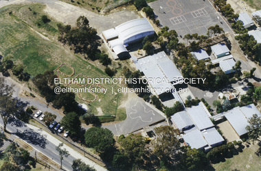 Eltham District Historical Society Inc
Document - Archive Box, 1570 Main Road, Research (Research Primary School)
Contents: 1. Andrew Lemon's Working File of Return to Research Andrew Lemon's Working File for his 1989 book, “Return to Research: A Centenary History of Research Primary School" (EDHS_00867). Includes a disassembled copy of the book. (All other documentation and photos passed to Research Primary School 3 September 2013) 1.1. EDHS_05004 - Cassette Tape of "Afternoon Tea with Senior Residents Nov 1st 1984" Reminiscences, chit chat and banter between group of senior citizens at an afternoon tea held for them at Research Primary School. 1.2. School Register 1935-1994 (Box 1) Photocopy of Research Primary School register from 1935 to 1994 (originals held at school) From 1994 onwards registrations were made online via the Education Department CASES system. 1.3. School Register A-Z 1935-1987 (Box 2) Computer print-out of alphabetized register 1935-87 (Research Primary School) (Done by David and Sue Grigg in 1987 from the register) Contains some extra details/corrections/current addresses Plus disks containing this data (not housed in box – there is a separate floppy disc box containing several 5 ¾” and 3 ½” floppy disks which are not readable as no hardware/software to support) 1.4. Research Locality History (Yellow Folder 1) Research Locality History Newspaper cuttings, Photocopies etc Collection for Research Primary School History 1989 Contents • 3 x photocopies (A3) regarding sale of Raglan Estate, Research [2 x A3 and 1 x composite A3 colour photocopy] • Souvenir Map of area with pictures of historical items and wild life - A Visitor's Guide Map; ELTHAM, WARRANDYTE and Environs (see also EDHS_01633-1) • EO article 26 Mar 1897 "Research State School picnic expedition to Mordialloc" • TA article 25 Jul 30" Research Affairs" plus an add for J Ingram's Research Bakery • DVN articles 14 Jan 69 (2 pages) "Research Fire Victim (Bill Pelling) still in hospital" • DVN 14 Jan 69 Page of Deaths, In Memories, Obituaries, Church Notices, Public Notices and Notices • Age article 24 Jan 84 "Eltham before the Mud Bricks" • DVN article 21 Oct 86 "Facing Good and Bad Times with enthusiasm - Keith Maxwell" • DVN article 29 Aug 87 "Eltham - the historic haven" • DVN article 25 Aug 87 "Eltham - a piece of living history, (the historic haven cont…)" • DVN article 20 Oct 87 "When push bikes were made for touring - Sam Howard" • 6 x pages of what appear to be various student's workbooks/ projects from 1944/45 era • ''They lost their homes- Historical places go at Research" plus other articles on fires 8 Jan 69 [Located in Folder 2] • DVN articles 23 Oct 84 "Centenary Plans" & Folklore surrounds Research township" [Located in Folder 2] • DVN article 23 Sep 86 "The teacher who had cut cane but never used one" Frank Sheehan (3 copies) [Located in Folder 2] • 2 x copies of booklet "Memories of Eltham" [Located in Folder 3] • Photocopy of subdivision Parish of Nillumbik [Located in Folder 4] DVN = Diamond Valley News, EO = Evelyn Observer TA= The Advertiser 1.5. Copies of items held by Public Records Office Victoria (Yellow Folder 2) Copies of items held by Public Records Office Photos and display items from Research Primary School Centenary August 19, 1989 • Laminated photocopy: “State School No. 2959, Copy of the above school property,” signed Henry L. Cole 18.6.91 • Photocopy: Petition for a school at Research, 13/11/1888; Public Record Office Victoria School Building File – School 2959 CUPRS 795/1717 • Photocopy: Negotiation to buy school site – part of Allotment 2, owned by the West family (copy attached to letter) 15/1/1890; Public Record Office Victoria School Building File – School 2959 CUPRS 795/1717 • Photocopy: Frank Scott, Head Teacher Research 1904-1907, letter of explanation (first page) to Department re poor results by pupils at the school, 24/8/1907; Public Record Office Victoria School Building File – 640 / School 2959 • Photocopy: Anton Brinkkotter’s Certificate for Regular Attendance 1908 (This was ‘traded in’ in 1911 for a certificate to mark six years without missing a day of school; Public Record Office Victoria School Building File – 640 / School 2959 for 1911 • Photocopy: Education Department Memorandum 1949 re need for extensions and improvements; Public Record Office Victoria School Building File – 795 / School 2959 • Photocopy: Looking to the future about expanding site for additional land for play space, 1950, Education Department Inspector to Department; Public Record Office Victoria School Building File – 795 / School 2959 • Photocopy (laminated, 2 sheets) First School Fire -1953 copy of Police Report. The old school building was badly damaged but repaired. It burnt down in 1976; Public Record Office Victoria School Building File – 795 / School 2959 • Photocopy: The Argus (28 July 1953) & the (Sun 28 July 1953) Two newspaper cuttings and notes re school fire 1953; Public Record Office Victoria School Building File – / School 2959 • Photocopy: Head Teacher Reg Jackman expresses concern to Education Department about conditions as he takes charge of Research State School, 1957; Public Record Office Victoria School Building File – 640 / School 2959 • Photo print (x2) of Education Department Qualifications and Certificates, Lyla Dickson, State School. (1) Print missing (2) Education department Victoria, Merit Certificate, This is to certify that Lyla Dickson has completed satisfactorily the Course of Study presented for the Eight Grade in Elementary Schools, dated at research Elementary School, this 20th day of November A.D. 1923 • Copy of original photo owned by Nell Howard “Fancy dress night in the school house – 1920s”, black and white print, 10.5 x 18 cm, attached to A4 photocopy of photo with names inscribed10.5 x 18 cm • Copy of original photo (stamped Reynolds Collection), black and white print, 24.5 x 16 cm, attached to paper sheet 37.6 x 25.5 cm, inscribed “Miss Doney” and “Elizabeth Doney and her family owned and ran Research’s Store and Post Office for many years after buying the property from the wests. This land surrounded the school site and includes today’s [1989] Kanandah Ct, Raglan St and shops” • Black and white photo print, 20 x 25 cm, Reconstruction of Main Road in front of Research Primary School, August 1989 • Black and white photo print, 20 x 25 cm, Eastern end of old oval, Research Primary School, 1989 • Black and white photo print, 20 x 25 cm, Portable Buildings, Research Primary School, 1989 • Black and white photo print, 20 x 25 cm, Gymnasium, Research Primary School, 1989 • Black and white photo print, 20 x 25 cm, Administrative Art Building, Research Primary School, c.1989 • Black and white photo print, 20 x 25 cm, Betty Kicker, Cleaner at Research Primary School, c.1989. Betty worked at the school from early 1970s to 1990s 1.6. ‘Memories of Research 1951-1968’ (Yellow Folder 3) Interview by Sue Grigg of Florence Egglestone for publication in Return to Research. Original handwritten notes, ‘Memories of Research 1951-1968’ 1.7. Centenary Committee Minutes & Newsletters (Yellow Folder 4) Centenary Committee Minutes and Newsletters Information regarding attendance of 100th anniversary including lists of staff contact details 1983-1986 Request (1985) to Shire of Eltham Historical Society for information and memorabilia • Letter: Ann Bouchier, Convenor – Centenary Committee, Research Primary School to R. Yeoman, Shire of Eltham Historical Society, 15 October 1985; enquiring about memorabilia etc that could be used in a proposed compilation on the “History of the School.” • Minutes of Meeting, Centenary Sub-Committee, Research Primary School Council o 17 June 1985. Also includes a list of general aim, specific aims and methods for the research Primary School Centenary - 1989 o 15 October 1985. o 17 September 1986. o 20 August 1987. o 2 May 1988. o 9 June 1988. o 22 August 1988. o 12 October 1988. o 24 November 1988. o 17 April 1989. o 24 July 1989. • Outline of Historical Events 1884-1954 (3 pages) • Centenary Newsletters o Number 1 (1989) o Number 2 (1989) o Number 3 (1989) o Newsletter (c. Aug. 1989) • Information re attendance of 100th Anniversary, Research Primary School, 19 August 1989 o Research Primary School – Staff 1984 (includes Name, Address, Telephone) o Research Primary School – Staff 1985 (includes Name, Address, Telephone) o Research Primary School – Staff 1986 (includes Name, Address, Telephone) o Emergency Teacher List 1983 o Emergency Teacher List 1986 o Previous teachers 1984 on • Quotation No. 733, Major Graphics for Engraved Brass Commemorative Plaque for opening of School Gymnasium • Centenary Invitation; Program and Souvenir and Chicken & Champagne Supper order forms • Various Centenary Invitation lists with notations, and various returned RSVPs • Centenary Program and map • Photocopy: 11 pages typed with hand corrections, draft manuscript for Andrew Lemon’s book, Return to Research (pages 13-24) • Bulletin: “I’m an Aussie” Week – 15th-19th April 10/4/85 • Bulletin: Research Centenary 26/4/88 • Bulletin: Official Centenary Logo For Research Primary School 15/12/88 • Bulletin: Centenary School Activity – “Colonial School” 23/5/89 • Bulletin: Centenary Activity Days – Monday, 14th August, Tuesday, 15th August 7/8/89 • Advertisement: A3 photocopy, Centenary Bush Dance, Sat. 4th March featuring “Paradiddle” Bush Band • Photocopy Master: Invitation (blank) to attend “Return to Research” celebration and Official Opening of the School Gymnasium on Saturday, August 19th from 1.00p.m. to 5.00p.m. and attached RSVP (also includes yellow paper sample -blank) • Photocopy Master: Tickets for Centenary Chicken & Champagne Supper, Friday, 18th August 1989, 7.30p.m., $5.00 per head (2 yellow paper samples marked on reverse ‘13’ and ‘55’) • Photocopy Master: Centenary Gift Donated by slips including multiple blank samples • Promotional Notices o Letter, Robert Wenn, Principal, 29 November 1988 for placement of “HELP WANTED” in Public Notices of The Age o Information provided to Ian Reid Real Estate Agent for Board to promote Centenary Bush Dance Paradiddle Band, Saturday 4 March 1989 o Notice Board promoting ‘Old Time’ Gala Fete Saturday 17 June 1989 o Letter, Robert Wenn, Principal, 24 August 1989 to Ian Reid Real Estate thanking for support of Centenary celebration and successful book launch and seeking further support for next event being school musical production “Spirit of Research” written by Andrew Lemon to be performed December 7th. 1.8. 1989 Research Primary School Centenary Visitors Register and Sue Grigg Correspondence (Red Folder) Sue Grigg’s Folder of Visitors to 1989 Centenary Celebrations and correspondence to Sue Grigg as organiser of Centenary Celebrations • 22 A3 Sheets of 1989 Research Primary School Centenary Visitors Register (approx. 238 entries) • Correspondence to Sue Grigg as Organizer of Centenary Celebrations o Trace B? – Ingram, Dunolly, 30 January 1990 re photo of Ingrams Road. Includes hand drawn map of various buildings on Ingrams Road. Also black and white print copy (12.5 x 17.5 cm) of photo of Ingrams and Main Road (possibly one sent to her) – see SEPP_0511 o Barbara Booth (nee Coles); thanks for wonderful celebration o Len and Marlene Parsons, 21 August 1989 o Mrs R. Towers, n.d. thanks for school photo ordered o Winifred L. Lade, 7 August 1989, gg grandparents William and Mary Crozier, daughter Sarah married Thomas Baillie (her g grandparents). Thomas Baillie was one of the petitioners for the school o Winifred L. Lade, n.d., thanks for photo and map o Carol Mathews, thanks for celebrations and payments for photos. Written on reverse of Sue Grigg’s letter to her of 19 September 1989 o Kenneth Ingram, Monday 14th, thanks for invitation but unable to attend • Photo of Ingrams and Main Road 1.9. Student Photos c.1970s (Buff Folder 1) [Not in Archive Box] Quantity of photos of students taken by Mrs Avril Baker (Staff Member) In 1970s 1.10. 1989 Centenary Questionnaires (Buff Folder 2) Research Primary School, 1989 Centenary Questionnaires from school families (approx. 190 responses) 1.11. Archive and Class Photos 1890s-1961 (Buff Folder 3) • Archive photographs of Research and District; 10 x 15 cm prints and digital files on thumb drive (copied to Collection catalogue) o RPS 1- Henry Cole Head Teacher 1891 to 1903. Photo from Mrs E. Williams o RPS 2 - Mary Jane Cole with eldest daughter Doris c 1905 o RPS 3 - Wedding Photo Mary Jane Rodda and Henry Cole o RPS 4 - Joseph Rodda of Chun Grove, Research o RPS 5 - Walter Rodda 1917 son of Joseph Rodda o RPS 6- Henry Cole and Pupils 1897 (Reynolds Collection) o RPS 7 - Elizabeth Doney (Reynolds Collections) o RPS 8 - Doney's Store early 1960's o RPS 9 - Main Road Research to Left, lngrams Road to Right o RPS 10- Main Road Eltham from Griggs family o RPS 11- Eltham near Station from Griggs family o RPS 12 - The Main Street Eltham from Griggs family (Rose Series 4344) o RPS 13 - The Rev and Mrs Thomas Cole. Parents of Henry Cole o RPS 14- Henry Cole as a boy with older brother Tom. From Mrs E. Williams. o RPS 15- Mary Jane Rodda as Mrs Henry Cole, Sewing Mistress Research State School 1891 to 1897 o RPS 16 - Etta Rodda Sewing Mistress Research State School 1897 -1904 o RPS 17 - Frederick Rodda son of Joseph Rodda o RPS 18- Bush Fires 1963 o RPS 19 - The view to the northeast from the top of the School Grounds 1989 o RPS 20- Edwin Rodda son of Joseph Rodda • Class and Staff photos, some with lists and names for identification [see separate folder of digital files – no hard copies in folder] Decade Years Represented 1890-1899 1897 1900-1909 1900, 1904 1910-1919 1910 1920-1929 1922, 1925 1930-1939 1930, 1932, 1937 1940-1949 1940, 1942 1950-1959 1950, 1951, 1952, 1953, 1954, 1955, 1956, 1957, 1958 1960-1969 1960, 1961, 1969 1970-1979 1970, 1971, 1972, 1973, 1975, 1976, 1977, 1978, 1979 Staff: 1971, 1976, 1978, 1979 1980-1989 1980, 1981, 1982, 1983, 1984, 1985, 1986, 1987, 1988, 1989 Staff: 1981, 1982, 1985, 1986, 1987, 1988, 1989 1990-1999 1990, 1991, 1994, 1995, 1996, 1997, 1998, 1999 Staff: 1990, 1994, 1995, 1996, 1998, 1999 2000-2009 2000, 2001, 2002, 2003, 2004, 2005, 2006, 2007, 2008, 2009 Staff: 2000, 2002, 2003, 2004, 2005, 2006, 2007, 2008, 2009 2010-2019 2010, 2011, 2012, 2013, 2014 Staff: 2010, 2011, 2012, 2013, 2014 • Class names; 4 pages handwritten and 2 numbered diagrams of Class names: o 1942 whole school o 1975 Grade 1 o 1976 Grade 2-3 o 1977 Grade 3 o 1978 Grade 4 o 1979 Grade 5 o 1980 Grade 6 • Negatives of photographs, 1 x roll of 36 and contact prints, copied at or for the Centenary 1989 o Neg. S – same as Neg. 27 o Neg. 1 – 1961 2/3 o Neg. 2 – 1960 5/6 o Neg. 3 – 1960 2/3 o Neg. 4 – 1960 Prep o Neg. 5 – 1957 Gr 2 o Neg. 6 – 1956 1A & II o Neg. 7 – Prep & I o Neg. 8 - 1955 o Neg. 9 – 1955 I & II o Neg. 10 – 1958 Gr II o Neg. 11 - 1960 3A & 4 o Neg. 12 – 1961 4 & 5 o Neg. 13 – same as Neg. 17 o Neg. 14 - 1925 o Neg. 15 - 1930 o Neg. 16 - 1942 o Neg. 17 – 1927 whole school o Neg. 18 - 1937 o Neg. 19 - 1932 o Neg. 20 - 1953 o Neg. 21 – 1951 Prep - 3 o Neg. 22 - 1954 o Neg. 23 - 1952 o Neg. 24 – Gr 4-7 o Neg. 25 – 1956 V & VI o Neg. 26 - 1940 o Neg. 27 – 1961 Gr 1 & 2 o Neg. 28 – SEPP_0610 (and 12.5 x 17.5 cm black and white print) o Neg. 29 – SEPP_0611 (and 12.5 x 17.5 cm black and white print) o Neg. 30 – SEPP_0612 o Neg. 31 – SEPP_0516 o Neg. 32 – SEPP_0509 (and 12.5 x 17.5 cm black and white print) o Neg. 33 – SEPP_0510 o Neg. 34 – SEPP_0511 o Neg. 35 – SEPP_0513 • Requests for copies of photos including explanation from Andrew Lemon that copies were made by camera of original photos provided by their owners • Colour photo print (copy of original), 12.5 x 17.5 cm, Doney’s Store, Main Road, Research, early 1960s including black and white photocopy of original print showing slightly wider field of view • Colour photo print, 10 x 15 cm, marked on reverse “19A” and “1 copy”, Aerial view of Research Primary School, c.1989 • Black and white print, 9 x 9 cm, Burnt out houses Ingrams Road Research near Cassell's Road after 1963 bushfire • Black and white print, 9 x 9 cm, Sight see-ers Ingrams Road Research near Cassell's Road after 1963 bushfire • Black and white photo print (copy of original), 20 x 25 cm, A memento of the Eltham Higher Elementary School Past Pupils Association Ball, Research Hall, 9 October 1966; inscribed and stamped on reverse “Reynolds Collection” • Colour photo print (copy of original), Kodak A4 photo paper, Pittaways cnr Main Road and Parsons Road c.1968 • Colour photo print (copy of original), Kodak A4 photo paper, Pittaways cnr Main Road and Parsons Road, my dad’s boat, c.1970, • Black and white photocopies of photos from Reynolds Collection o EDHS_00799-20 - The Research Hotel o EDHS_00799-22 - General Store, Research o EDHS_00799-27 – Plumtree Creek, Blashik family home, Ingrams Road o EDHS_00799-30 - Research o EDHS_00799-34 - Research Gully Bridge, Research Gully Road, c.1895 o EDHS_00799-35 - Research o EDHS_00799-37 - Waiting for the taxi-bus, Main Road, Research o SEPP_0524 - A Bush Home - Research, Vic.. 1.12. Research Primary School Centenary 1989 Display Photos (Buff Folder 4) 7 display pages, 37.8 x 25.5 cm, with 10 x 15 cm sepia coloured reproduction photographs attached and handwritten notations [some have come loose or missing] • Henry Cole, Head Teacher, Research, 1891-1903 o RPS-14 Henry Cole as a boy with his older brother Tom o 2 photos as a young man (missing) • Rodda Family, Jospeh B Rodda and two of his daughters o RPS-4 Joseph Rodda of Chun Grove Research o RPS-15 Mary Jane Rodda as Mrs Henry Cole, Sewing Mistress, Research State School, 1891-1897 o RPS-16 Ettie Rodda, Sewing Mistress, Research State School, 1897-1904 • Cole Family o Henry Cole, Head Teacher, 1891-1903 o RPS-3 Wedding photo 1894, Mary Jane Rodda and Henry Cole (missing) o RPS-2 Mary Jane Cole with eldest daughter, Doris, c.1905 (missing) • Cole Family; The Rev. and Mrs Thomas Cole, parents of Henry Cole o Rev. Thomas Cole o Mrs Thomas Cole o RPS-13 The Rev & Mrs Thomas Cole parents of Henry Cole • Cole Family o Reg Cole, O.B.E., as Town Clerk of Hobart meeting Queen Elizabeth and Prince Phillip, 1954. HJR (Reg) Cole was the eldest child of Henry and Mary Jane Cole, and was a pupil at Research State School c.1900-1903 • Sons of Joseph B. Rodda of ‘Chune Grove’, Research o RPS-17 Frederick Rodda o RPS-20 Edwin Rodda o RPS-5 Walter Rodda, 1917 • The Aqueduct (20 x 25 cm black and white reproduction print); built for opening in 1891 to take water from Maroondah to Reservoir (Reynolds Collection) 1.13. Class Photos (photocopies) - with names identified at Centenary 1989 (Buff Folder 5) [Not in Archive Box] Research Primary School- Class Photos (photocopies) -with names identified at Centenary 1989 1964 - 1984 1.14. News Paper Cuttings (Folder 2) News Paper Cuttings • Diamond Valley News - 23 Oct 1984-Centenary Plans - Folklore surrounding Research Township • Diamond Valley News 23 September 1986 - The Teacher who had cut can but never used one (4 copies) • Diamond Valley News- 20 October 1987 - When push bikes were made for touring (2 copies) • Diamond Valley News-14 January 1969 - They lost their homes (Historical places go at Research) • Diamond Valley News- 14 January 1969 - Bush Havoc ( 10 houses burnt at Warrandyte) • The Age - 24 January 1984- Eltham before the Mud Brick • Diamond Valley News - 14 January 1969- First Fire Call came at 10:25 am • Diamond Valley News - 14 January 1969 - Black Wednesday • The Advertiser- 25 July 1930- Research Affairs and add Research Bakery • Evelyn Observer - 26 March 1897 - Research State School part of a district schools expedition to Mordialloc (2 copies) • Diamond Valley News- 21 October 1986- Facing good and bad times with enthusiasm • Diamond Valley News- 14 January 1969 -Obituary David Leslie Mitchener • Diamond Valley News- 25 August 1987 - Eltham - the historic haven (2 copies) • Diamond Valley News-14 January 1969 - Research fire victim still in hospital 1.15. Reminiscences (Folder 3) • Memories of Eltham (Multiple authors) (2 copies) • List of names of children who attended Research Primary School as recalled by Kenneth Ingram (b.1907) provided in 1987 by his niece Grace Burrows (nee Ingram) including names of students and teachers she recalled from her time at school 1936-1941 • Photocopy of Interview by Sue Grigg of Florence Egglestone for publication in Return to Research, ‘Memories of Research 1951-1968’. [Original handwritten version in Yellow Folder 3.] 1.16. School Site and Buildings (Folder 4) • 3 x photocopies of photos of early school building • Raglan Estate Research • Plan of subdivisions Research 1920s • 1981 Education Department Building Operation process to be followed in the event of criminal damage 1.17. School Historical Documents (Folder 5) School Historical Documents • Certificate of Merit Ernest Reynolds • Inventory of Books and Equipment 1891 • Letter from Teacher Frank Scott explain poor results • Letter from Henry Cole recommending appointment of Mary Jane Rodda as Sewing Mistress • Special Certificate for Regular Attendance Anton Brinkkotter (2 copies • Certificate of Merit Anton Brinkkotter 1911 • Merit Certificate Lyla Dickson 1922 • Special Certificate for Regular Attendance Margery Palmer 1927 • Letter from Head teacher Reg Jackman 1957 • Petition to Education Dept 1884 from Research Gully to open a school • Joseph Mankey's complaints about temporary classroom 1890 • Research 1890 - Plan of one acre site to be purchased by education Dept for permanent school • List of buildings and dates • Need for extensions and improvements 1949 • Looking to the Future 1950 • Negotiations to buy school site 1890 2. Magenta Folio 1. USB drive containing • Class photos 1897-2014 • Class photo names • List of head teachers/Principals 1989-2014 • List of Infant Productions 2001-2010 • School photo names typed up identified at centenary reunion 1925-1984 • List of school camps 1964-2014 • List of Senior Productions 1986-2014 • Staff list 1989-2014 • List of grades by year taught by Mrs Avril Baker 1976-2010 2. CD of School and Class Photos 2013-2014 including laminated print of school photo 2014 3. 2 x CD of photos of Research Remembered. CD 1 containing 20 images of various activities from Centenary Celebrations and CD 2 containing 12 images of various student activities (1990s) 3. Clear Folio 1. Additional RPS Material • History of Research State School No. 2959; F.P. Sheehan (Principal) and Mrs M. Allwood (Historian) – duplicate copy of EDHS_03095-1570 held in Main Road property file. • Invitation; The Official Opening of 4 New Classrooms & Library Extension • Program; The Official Opening of 4 New Classrooms & Library Extension, 27 April 1996 • News clipping; Remember Sleepy Swipers Gully? Diamond Valley News, July 22, 1980, pp28-29 • Site plan of building layouts • Colour photo paper print of Rob Wenn’s retirement, June 1999 • Email from former teacher Brett Barnett sent March 2008 (teacher 1967-1980) with references to pet python that students would look after, and which perished when original school building used as a library burnt down • 2 letters (2009) from Peta McGinley offering some papers and photos for school archives. Her father, Rix McGinley was Principal for 1984 till his retirement in 1987. She was also a casual Relief Teacher in her first year of teaching in 1984. • List of 60 names associated with engraved bricks 2. 100th Anniversary 1989 • News clipping; Celebrations and nostalgia at school, Diamond Valley News, Tuesday, August 29, 1989, p28 3. 120th Anniversary 2009 • Notes of contact details of some former students who expressed interest in a reunion 4. 125th Anniversary 24 August 2014 • 3 pages handwritten of reminiscences of a group of mums whose children attended RPS during the 1980s. • 2 pages dated 29 March 2014 typed by Janet Page (nee Zambra) of reminiscences of her years at school (1948-1954) in support of 125th Anniversary Reunion (24 August 2014) sent to Joy Pagan with some queries noted by Maggie Sakko • Reminisces (single sheet double sided handwritten) of teacher Mrs Jacqui Edwards 1989-2001 retired and Casual Relief Teacher 2001-2014 sent to Maggie Sakko in support for 125th Anniversary book and follow up queries from Maggie Sakko (18 July 2014) • List of regular Casual Relief Teachers established by Brooke and Maria for Maggie Sakko • Two pages of working notes • News clipping: Ring in the years, Diamond Valley Leader, Wednesday, August 27, 2014, p1 – Illustrated – “Koray, Aidan and Lasenya helped ring in the 125th anniversary of Research Primary School. A huge reunion brought together past and present students and staff who reminisced about their school days. Report Page 14” • News clipping: School back to the past, Diamond Valley Leader, Wednesday, August 27, 2014, p14 – Illustrated (2 copies) • Poster: Arbor Week June 23-29 (2008) – Arbor Week is the same age as Research Primary School – note written on poster to possibly include tree planting as part of 125th celebrations 5. Centenary of Federation Medal presented to students of Research Primary School (2001) by former student, Miss Ivy Reynolds • Letter: Ivy Reynolds to staff and children, May 22, 2001, letter of thanks for privilege of sharing the celebrations with her • 9 x laminated paper colour prints of students with medals and Ivy Reynolds main road, property, research (vic.), research state school no. 2959, caledonian gold field, swiper's gully, wallaby town, research gully, discovery gold plenty ranges, fountain of friendship hotel, ray morris, alice russell, norma family, bettison family, reynolds family, william west, joseph m makey, henry james cole, mary jane rodda, florissa milton, f p sheehan, m allwood, research hotel -
 Surrey Hills Historical Society Collection
Work on paper - Vertical file, Chatham Primary School
CHATHAM PRIMARY SCHOOL 4314 -FILE 1 1. Correspondence regarding establishment of the school – all are copies: • Letter from Amy Brown to Secretary of Chatham School Committee (undated) relating to correspondence regarding the establishment of the school • Letter from Education Department to Mr. A.R. Brown, 17.5.1923. • Letter from Department of Public Works to Mrs. Amy R. Brown, 2.10.1923. • Letter from Education Department to Mr. A.R. Brown, 2.11.1923. • Letter from A. Brown to Education Department ?, 7.11.1923. • Letter from E.W. Greenwood, MLA, State Parliament House to Mr. A.R. Brown, 8.11.1923. • Letter from E.W. Greenwood, State Parliament House to Mr. A.R. Brown, 19.11.1923. • Letter from Department of Public Works to Mrs. Amy R. Brown, 5.12.1923. • Letter from Education Department to Mrs. A. Brown, 8.12.1923. • Letter from A. Brown to Mr. Greenwood, 26.7.1925. • Letter from E.W. Greenwood, State Parliament House to Mrs. A. Brown, 14.3.1925. • Letter from E.W. Greenwood, State Parliament House to Mrs. A. Brown, 15.7.1925.Letter from E.W. Greenwood, State Parliament House to Mrs. A. Brown, 16.11.1925. • Letter from Department of Public Works to Mrs. A. R. Brown, 10.11.1926. • Letter from E.W. Greenwood, State Parliament House to Mrs. A. Brown, 2.3.1923. • Letter from E.W. Greenwood, State Parliament House to Mrs. A. Brown, 3.6.1927. • Letter from E.W. Greenwood, State Parliament House to Mrs. A. Brown, 29.6.1927. 2. 2 Mr. Harbert’s account for Shelter Shed, Chatham State School, (undated), (1 page). 3. 4 copies of newspaper cuttings: • ‘Masts tell Edina’s history’, Herald, 4.5.1931 • ‘Edina to have holiday on 80th birthday’, Argus, 4.5.1934, • ‘Edina’s birthday tomorrow’, Age, 4.5.1934, • ‘Old lady of the sea has a birthday’, Star, 4.5.1934 (1 page). 4. ‘The story of the steamship “Edina” a wonderful veteran of the seas’, The Meccano Magazine, A.R. Prince, December, 193 ? (1 page). 5. ‘Ponsford and schoolboys’, (paper and date unknown), (2 pages). 6. Program for ‘Trial by jury’, 16.11.1929 (1 page). 7. ‘What was the joke that the Governor told?’, paper unknown, 5.5.1931 (1 page). 8. ‘History in school flag’, paper and date unknown (1 page). 9. Lists of girl and boy dux 1928 – 1944 (1page). 10. Chatham School 4314 notes (undated) (3 pages). 11. Extracts from Box Hill Reporter, 1927-9, from Alan Holt collection (1 page). 12. Empire day celebrations in Surrey Hills in 1930s, notes from Matt Bowen, 1983 (1 page). 13. Extracts from Box Hill Reporter 1927-8 (1 page). 14. Vision and realisation, 1973 Education Department : Port Phillip Eastern Region: 4314 Chatham notes by H.H. Singleton (1 page). 15. ‘Bell has historic appeal’, paper unknown, c. 1985 (1 page). 16. Background information on the SS Edina bell, Adrian Peniston-Bird, Principal of Chatham Primary School, 1982 (1 page). 17. ‘It’s there for another fifty years’, October, 1985. See also ‘Chatham past and present, a patchwork of people’. (1 page). 18. ‘Miss Marie George’, SHNN No. 40, June/July, 1989 (1 page). 19. ‘Chatham Primary School – a community within the community’, SHNN No. 56, Feb/March, 1992 (1 page). 20. ‘Chatham Primary School – another exciting year begins’, SHNN No. 68, Feb./March, 1994 (1 page). 21. ‘Chatham plans a big reunion’, SHNN No. 77, Aug./Sept. 1995 (1 page). 22. ‘In search of the past’, Progress Press, 15.5.1996 (1 page); features Norma Price & Lale Ramadan 23. ‘Chatham primary’, SHNN No. 82, June/July, 1996 (1 page). 24. ‘Happy Birthday, Chatham Primary’, SHNN No. 84, Oct./Nov. 1996 (1 page). 25. Chatham School Fathers Club, SHNN No. 83, Aug./Sept. 1996 (1 page). 26. Notes by Doug Iversen, 18.7. year unknown, (1 page). 27. Advertisement for Chatham Primary School celebrating 70 years: ‘Take a walk down memory lane’, 10.9.1996, paper unknown (1 page). 28. Chatham Primary School invitation to 70th year celebration – Sat. 19.10.1996 (1 page), AND Back to Chatham (1 page). 29. Flyer: Chatham Primary School Reunion Celebrating 70 years 19.10.1996 (1 page, 2 copies). 30. Program ‘Welcome to Chatham Primary School No. 4314 70th celebration’, undated (1 page, 2 copies). 31. Chatham History trail, undated (1 page). 32. Card with drawing of Chatham Primary School by David Williams, 1995 (1 page). 33. ‘Seems like yesterday’ 1998, paper unknown (1 page). 34. ‘Schools and the environment’, SHNN No. 98, Feb./March, 1999 (1 page). 35. ‘School praises retiring head’, by Kate Morris, 19.6.2000, paper unknown (1 page); features Jan Morris. 36. “Chatham’s class of ‘30” by Meg Freeman, Progress Press, c. July, 2000 (1 page). 37. ‘Recalling a class act’, Progress Press, c. August, 2000 (1 page). 38. List of students enrolling in 1930 (2 pages). 39. Chatham Foundation Day Lunch invitation 31.7.2000, (with contact details of former students on the back, written by Ken Hall) (1 page). 40. ‘Boy in man’s shoes’, Progress Press, 21.8.2000 (1 page). 41. ‘An invitation – Chatham Primary plans for its 75th birthday’, SHNN No. 118, June/July, 2002 (1 page). 42. 75th birthday assembly – August 1st 2002 (1 page). 43. ‘Chatham lands special garden’ (paper and date unknown, possibly Progress Leader) (1 page). 44. ‘Chatham Primary celebrates specialist programs’, SHNN No. 184, June/July 2013 (1 page). 45. ‘City’s sustainable schools awarded this month’, Boroondara Bulletin, April, 2013 (1 page). 46. ‘Chatham Primary walks to win’, SHNN No. 189 March/April 2014 (1 page). 47. ‘School builds pathway to greater sustainability’, Progress Leader, 15.9.2015 (1 page). 48. ‘Schools embrace need for class action’, Age, 7.11.2016 (1 page). 49. Advertisements for 2017 grand fair 4th March, 2 designs (3 pages including 2 copies of one). 50. Chatham primary leads on going green – SHNN No 160, June /July 2009. 51. A history of Chatham Primary School, golden jubilee edition 1977 (9 pages with covers). 52. Photo of Mrs. Frances Le Couteur receiving a gift at Chatham Primary School, golden jubilee 1977 (1 page – a copy). 53. ‘Thank you’ letter to editor from Mrs. Frances Le Couteur (paper unknown), 1977 (1 page). 54. Letter from Chatham School No. 4314 to Mrs. Ethel Cerini, 10.2.193 ? (1 page). 55. Programme for concert held in the 1930s (source possibly Jocelyn Hall) (1 page). 56. ‘Parents’ pride in their school’, Progress Press, 21.5.2019. 57. ‘Bring your bright ideas to life’, Whitehorse Leader, 13.5.2019 (features Otto Hunt). 58. Flyer for school fete, 1986/1987 59. ‘Hearts captured, now for minds’, 2020, no details re paper. 60. ‘Teachers feted with hearts’, Age, 26.5.2020. (Response to COVIDE lock down) 61. ‘Wedding memory renewed’, (? Progress Press). 2.12.1997 features Ivy & Basil Taylor, former Chatham students. 62. Reflections of Principal, Chris Cotching, SHNN No 233, Feb 2022. 63. School brochure, c1998 64. School calendar 2003 65. Copies of photos taken by sue Barnett at the time of the 70th Reunion (8 photos) 66. Signatures of staff and students from 1997 (10 pages) 67. Grand fair raffle tickets, November 2023 -
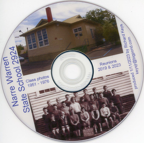 Narre Warren and District Family History Group
Document, Richard Keys, Narre Warren State School 2924 class photos 1951-1976 and reunions 2019 & 2023, 2023
... of the school's 2019 reunion, and 60 photos of the 2023 reunion ...The DVD consists mainly of images, with many class photos from 1951 to 1976 but not a complete set. Some photos have names, but not all. There are 60+ photos of the school's 2019 reunion, and 60 photos of the 2023 reunion, not everyone is named but some name tags are visible. A small set of historical photos of Narre Warren buildings and people complete the publication.1 optical discnon-fictionThe DVD consists mainly of images, with many class photos from 1951 to 1976 but not a complete set. Some photos have names, but not all. There are 60+ photos of the school's 2019 reunion, and 60 photos of the 2023 reunion, not everyone is named but some name tags are visible. A small set of historical photos of Narre Warren buildings and people complete the publication.narre warren state school 2924, narre warren (vic.) -- history, schools -- victoria -
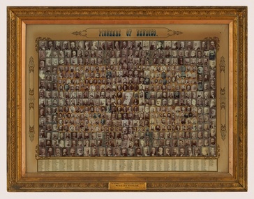 City of Greater Bendigo - Civic Collection
Work on paper, H Hansen, Pioneers of Bendigo 1851-60, 1894
Gift of Mr. W.D.C. Denovan, 1894Gilt framed photographic work consisting of 472 small individual portraits making up one large work with names of each of the men below. Centre and slightly larger portrait of George Lansell. Decorative mount. Plaque centre front of work.Presented to the Bendigo Art Gallery by / W.D.C. Denovan / 1894 (on plaque) Inscribed, l.l., pen and ink, "H. HANSEN. PHOTO"; l.r., "NEXT SCHOOL OF MINES, BENDIGO"; top, watercolour & pen and ink, "PIONEERS OF BENDIGO"; bottom, letterpress, list of names. -
 Northern District School of Nursing. Managed by Bendigo Historical Society Inc.
Document - Typewritten letter from Rae Rosten., School 22, including email from Heather Chislett (McCalman) with nursing reminiscences
Northern District School of NursingTypewritten letter from Rae Rosten discussing her response to having received copies of her training records and her further education and experience in diabetes and gerentology. Attached was an email from Heather Chislett (McCalman) describing a meeting with a patient she had nursed 60 years prior and he wished to thank her. Rae Rosten's letter has her signature.nursing -
Glen Eira Historical Society
Book - O’Neill College, Nagle Avenue, 2, Elsternwick
A commemorative history titled "O’Neill College 1908 – 1981" published at the time of the amalgamation of O’Neill College with star of the Sea, 1982 (2 copies). The book (64 pages) includes a short history of O’Neill college, reports from Monsignor Lyons, Principal's report and reports from various other sisters from 1930’s, 40’s, 50’s, 60’s and 70’s. Reminiscences from students activities in the 80’s. Many school photographs of staff, class photos, school outings, sporting events and year 9 camp. Date and author unknown.o’ neill college, sister margaret canoll, presentation secondary, nagle avenue, sister mary kavanagh, education committee, sister christine walsh, elsternwick, sister francis muirhead, peart leanne, sister marie therese harold, star of the sea college, collina filomena, gammaldi tony, mcwilliam lorraine, o'neill college mothers auxillary, mcwilliam barry, st. jospeh's school, sister mary claver stone, sister mary de sales mckenna, sister angela johnston, sister bonaventure harrington, cooper sheila, cooper robert, harnett eileen, harnett desmond, beldart dorothy, catholic schools, primary schools, secondary schools, land subdivision, richard o'neill ecclesiastical college, romanesque style, schreiber r.a., architects, diocesan teacher training college, registers, lists, diaries and journals, halls, kindergartens, school concerts, basketball, choirs, festivals and celebrations, fundraising events, sport, harrison bessie, lynch eileen, murray veronica, mullamby kathleen, mullamby mary, mullamby eileen, miller joseph, strachan barry, webster mary, waldam geoffrey, checchi norman, delaney ella, hooper george, cahill john, cooper john, doyle albert, sister catherine walsh, carr archbishop, mother mary peter fitzgerald, couch mary, couch ambrose, checchi thomas, cahill francis, cooper robert, cooper sheila, castieau margot, castieau john, collinson eileen, collinson john, carolan veronica, carolan james, coates emily, coates henry, cato helena, cato herbert, cato yootha, cahill vincent, cleverley ernest, cleverley francis, cleverley maisie, collins dorothy, collins alfred, clark madge, clark william, gough father, ryan father, morris father, sister benedicta, sister anglea, brennan father, o'neill sarah, riddell parade, mother peter fitzgerald, mother mary bernard justice, sister marie bernade, sister kath coury, hoy hubert mrs, dowling mr, dowling mrs, mclaughlin mr, mclaughlin mrs, collis-brown mr, collis-brown mrs, keane tom, smith coral-anne, dwyer coral, lyons monsignor, miller collin henry, sister catherine curtin, sister peter, sister laserian, sister clare, sister fintan, sister cyril, domec-carre inez, murphy eileen, miller joy, guiney leo, tennis, wood joyce, toomey marie, hayes teresa, sister mary chanel, cobern wanda, sister mary gabriel, jeffrey lorna, sister mary genevieve, pitt jean, clark veronica, phipps sheila, sister sheila, youngberry kathleen, sister benedict, lowday dulcie, sister anne-marie, keary brenda, briglia rita, sister immaculata, burns n., brennan b., wright s., baker e., brdawshaw billy, barnes joan, mason patricia, roberts connie, shelton june, murray betty, keane peggy, taylor audrey, feiss margaret, hoy rosemary, sans lydia, smythe victor, hoy agatha, souter bobbie, brennan kathleen, shelton moira, wallman vera, cox s., rogers s., brennan b., wright s., mckeeran k., power e., maloney j., fyfe p., wright e., chambers f., baker e., keary d., lynch maeve, mcilroy j., corrigan p., harris p., gill p., keogh k., hennessy d., garrett j., feiss j., deverall j., langley j., griffin moya, ashton norma, hull fay, linehan mary, murphy eileen, odgers shirley, brennan jean, mahony denise, meyer margaret, mornament ina, cox s., wright s., borelli marie, flanagan c., smythe p., whelan mary, hawkridge v., johnson v., filippina contessa, rawlings a.b., beer letty, sister mary joseph, eisma joan, langley joan, sister raymond, sister aloysius, garrett betty, sister gertrude, sister elizabeth, sister mary hilary, sister marie louis, stratford c., sister james cantwell, dance mrs., mcnamara colleen, share kath, sister adrian, sister patricia carroll, sister rose, sister pius, dunne patricia, sister james, sister sheila, sister jude, dawes pat, sister beatrice, mason june-maree, sister domenica, guatta win, sister marie cline, sister marie de lourdes, hale mrs, sister robert, sister merle, sister philomena, sister francis xavier, sister frances borgia, sister margaret bullock, sister bruna, mother peter, sister genevieve, kendall vern, collette leonie, sister philomena consedine, ashton francine, maher frank, mcgrath brian, van heeswick julie, west liz, ferrier fran, molloy miss, cooney jenny, tkalcevic josephine, sirianni lena, danielis simonetta, simmonds louis, richardson sharon, giannelli irene, carter louise, ettia gie, williamson helene, galli mrs, meagher mrs, fitzgibbon mrs, beveridge cathy, cocciardi bernadette, emmett mr, emmett mrs, brother moore, farrow sandra, warren angela, peters kim, tarcasio rina, tuohy helen, massey jayne, o'sullivan kerrie, killingsworth miss, conheady mrs, gray mrs, clark fiona, ferrier margaret, dotter andrea, muller mary, young samantha, aquilina tania, baker patricia, bean dianne, bouchereau brenda, brohier audrey, curtis debbie, ferrier frances, hynes nerida, jones leanne, krelle brenda, lamanna ann, loiacono chris, morin jackie, musster judy, renshaw susan, stratford margaret, hoareau marlene, clark nicole, o'neill college, williamson helen, victorian congregation of presentation sisters, sister margaret walsh, archbishop carr