Showing 9698 items
matching the road back
-
 Flagstaff Hill Maritime Museum and Village
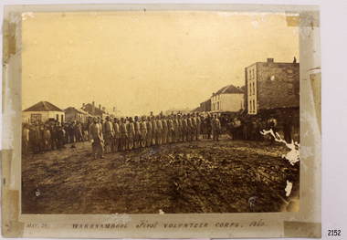
Photograph - Military group, Warrnambool First Volunteer Corps 1860, Taken May 24th, 1860, presented to Mayor in 1887
This Photograph is one of a number of photographs of the Warrnambool Militia. The photograph entitled "Warrnambool First Volunteer Corps" is dated 24th May 1860. (The First Volunteer Corps began in 1855.) It was presented by James Astley Bromfield (former Mayor of Warrnambool) to Major Walter Helpmann, head of Warrnambool’s 1st Volunteer Corps in 1887. The photograph shows the Corps lined up for inspection in Timor Street, Warrnambool. The location is outside what is now the Archie Graham Centre and the camera is looking west towards Liebig Street. The town band is in the right rear corner and spectators surround the Corps. The names listed on the back of the photograph are "1. R.Bushe (Captain in command), 2. Basil Spence, 3. Thomas Mickle, 4. Alfred Davies (Sergeant), 5. Cawthray, 6. Andrew Kerr, 7. Charles Scoborio, 8. Lacy, 9. James Hider, 10. D. O’Mullane, 11. William Norman, 12. Crouthers (or Cowthers ?), 13. Francis Breckon, 14. Russ, 15. Benjamin Wycherley, 16. C. A. Cramer (Sergeant), 17. James Coulstock, 18. Robert Newton (Sergeant), 19. J.A. Bromfield, 20. Singleton (supernumery), 21. Mostyn (Drill Instructor)," On the left of the picture is Billy Adams, Barnes (road contractor) and James Mason (Bootmaker). On the right of the picture is The Band. This is one of a collection of photographs showing the development of the Warrnambool Militia from its inception as the First Volunteer Corps in 1855. The collection is of local significance as it parallels the development of the town and includes images of significant local people. A number of Warrnambool streets are named after members of the Militia. It is also historically significant because of its connection to the unrest that was taking place in Europe at this time. Photograph of Warrnambool First Volunteer Corps 1860, sepia coloured, mounted on cream card. The photograph shows the Corps lined up for inspection in Timor Street Warrnambool. The location is outside what is now the Archie Graham Centre and the camera is looking west towards Liebig Street. The town band is in the right rear corner and spectators surround the Corps. Photograph taken 24th May 1860. Has names listed on reverse side. The protograph was presented to Mayor Helpman, by Bromfield, May 1887. Title printed below base of photo on the mounting board "May. 24. WARRNAMBOOL First VOLUNTEER CORPS. 1860" On the back of the photograph is a numbered list of names, handwritten in ink. Also on the back are presentation details "Presented to Mayor Helpman, by Bromfield, May 1887". warrnambool, wolunteer corps, militia, helpmann, bromfield, flagstaff hill, shipwrecked coast, flagstaff hill maritime museum, maritime museum, shipwreck coast, flagstaff hill maritime village, great ocean road -
 Flagstaff Hill Maritime Museum and Village
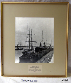
Photograph - Ships, South Warrnambool Primary School Centenary Committee, Unloading coal at Warrnambool Breakwater, 1977
This photograph was framed and mounted then presented to the South Warrnambool school by the South Warrnambool Centenary Committee in 1977 on the school's centenary year. The school was decommissioned and closed in the 1990s. In the photograph, people unload the coal from the ship beside the Breakwater and load it into the row of tramway carts. The coal would be sold to businesses and householders for the purpose of fuel for warmth, cooking, heating water and running machinery. The image shows the early days at the Port of Warrnambool. The building of the Warrnambool Breakwater had only just been completed. Steamships and sailing ships were frequent visitors to the port. Steam Navigation companies were plentiful, carrying passengers and freighting cargo such as coal, timber, food, livestock, furniture, hardware and haberdashery between Melbourne and the ports along the southwest coast of Victoria, including Warrnambool. The carts would take their loads into the township for distribution. The ship carrying the coal is thought to be the "S.S. Chillagoe" previously named "Speculant". In 1903 the Chillagoe was registered at the Port of Melbourne, and it sailed between Melbourne and Newcastle, New South Wales, where coal was mined and sold in significant quantities. In March 1890 a tragedy occurred when coal was being unloaded at the Warrnambool Breakwater. A local young man, David Ferrier, was working in the hold of the steamship Kurrara as its delivery of coal was being unloaded. A basket of coal fell from a sling onboard and came down upon Ferrier, breaking his back. He was not expected to live. In September 1890 there was a strike of coal workers but the Geelong Advertiser reported that a Warrnambool firm of coal merchants had recently received some large cargoes from Newcastle.The photograph is historically significant as it is connected with the local areas of the Warrnambool Breakwater, Lady Bay, and the South Warrnambool Primary School. The scene shows a moment in time when a steamship was unloading a shipment of coal onto tram carts on the Breakwater, which had only just been completed that year. The photograph was taken about 13 years after the opening of the South Warrnambool School, which was decommissioned around 20 years after it celebrated its centenary.. Photograph, black and white, in a gilded rectangular wooden frame, behind glass. The maritime scene shows figures on ships beside the Warrnambool Breakwater jetty and figures on the jetty, standing next to rail carts containing coal. There is a steamship further out on Lady Bay. A card below the photograph has an inscription and there is a pencil inscription on the back of the frame. The coal ship is thought to be the SS. Chillagoe. The photograph was taken in 1890 and was presented to the South Warrnambool School in its centenary year, 1977, by the South Warrnambool Centenary Committee.Typewritten on card: "UNLOADING COAL AT WARRNAMBOOL BREAKWATER"- 1890 - "Presented to Sough Warrnambool School by the SOUTH WARRNAMBOOL CENTENARY COMMITTEE - 1977 - " Handwritten in pencil on the back:"Speculant" as "SS Chillagoe" at Breakwater"flagstaff hill, warrnambool, maritime museum, maritime village, great ocean road, shipwreck coast, warrnambool breakwater, 1890, tramway, steamship, sailing ship, coal, cargo, port of warrnambool, unloading coal, chillagoe, speculant, newcastle, kurrana, david ferrier, coal strike -
 Flagstaff Hill Maritime Museum and Village
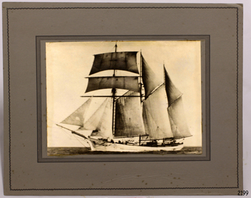
Photograph - Ship, Alma Doepel, 1931-1934
This photograph is of the square-rigged schooner "Alma Doepel". Details added to the back of the photograph incorrectly describe the vessel as "Amy Doepel / ketch / Amy Doepel". The rigging on the vessel dates the photograph to sometime between 1931-1933. The location is yet to be determined. Frederick Doepel was a shipping agent in Bellinger Valley, NSW. He employed an experienced shipwright to build Alma Doepel, which was made from local timber. He named the ship “Alma Doepel” after his baby daughter Alma. The ship was registered in Sydney and launched 19th October 1903, and her first sea voyage was in December. She traded in timber Port Macquarie/Bellinger River and New Zealand. “Alma Doepel” was purchased by Henry Jones & Co., Hobart jam makers, in partnership with Harry Heather, her new captain, in 1916. The ship was then registered in Hobart. She carried jam and timber to the mainland, particularly Melbourne, and brought back cargo for Tasmania. She even carried the piles for the building of Portland Harbour. When Harry Heather passed away in 1937 he was succeeded by Eric Droscoll. Before the square-rigged "Alma Doepel" left for Tasmania on March 8th 1937 she was fitted with a new set of sails, becoming a fore-and-aft rigged schooner. She had been the last 'top sail' schooner in Bass Strait trade! "Alma Doepel" continued her coastal trading until 1942, when she was requisitioned by the Army. In January 1943 she was left in Melbourne by her crew and the Army took her over, taking her to Sydney in February, 1943. She was relaunched by the Army in 1944 minus two of her masts and her small 1936 engine, and was fitted with three large bus engines. In March 1945 she headed for the war zone, delivering cargo up and down the coast of New Guinea, at one time carrying over 400 troops. In 1946 she returned to Hobart where the Army re-converted her back for Bass Strait trading and returned her. In January 1947 Eric Driscoll took “Alma Doepel” to the eastern Tasmanian coastal port of St. Helens, trading cargo of local mountain ash timber to Melbourne on the mainland until 1959. She was then stripped down to her hull with only a single mast and two engines, and fitted with wooden bins on rails in her hold. From 1961 to 1975 she carried limestone to a factory to make carbide. Michael Wood and David Boykett, two of the governors of "Sail and Adventure", then bought her for the price of her two Gardiner engines and in 1976 they brought her to Melbourne. An Alma Doepel Supporters Club was formed to support the ship’s major restoration to a topsail schooner. In 1987 she was overhauled in Adelaide, with the support of Elders IXL and she returned to Sydney to lead the Parade of Sail on Bicentenary Day, 25th January 1988. She returned to Melbourne in February and began sail training voyages in Port Phillip Bay, operating from an office on Station Pier. The Alma Doepel Voyagers Club was started. Trainees joined the crew in sailing the ship over nine or ten days of instruction in sailing and seamanship. These trips plus chartered trips and fund raisers continued until early 1999, when she was no longer in a condition to operate; she needed a lot of attention. She lay idle in Victoria Dock for quite some time. In April 2001 “Alma Doepel” was taken to Port Macquarie’s Lady Nelson Wharf where she became a museum ship maintained by volunteers. In 2008 she had time in dry-dock and after sea-trials headed off to Victoria Harbour, Docklands, in Melbourne, where she is currently being restored with the help of The Supporters.This phot graph is significant for its connection with the Bass Strait trade, being the last top-sail schooner to brade across the strait. The photograph is also significant in its representation of the the sailing ships that traded around Australia in the 1930s.Photograph of "Alma Doepel " a wooden, 3 masted, square rigged sailing schooner built in Sydney, launched in 10/10/1903. Photograph is sepia coloured, mounted on card, inscription on the back. Information also provided with photograph. Photograph (marked incorrectly on back) "Amy Doepel / ketch / Amy Doepel". Sticker with "91" in pencil. Information provided (dated incorrectly) "1943, Sydney, New South Wales"flagstaff hill, warrnambool, shipwreck coast, maritime museum, maritime village, photograph, alma doepel, frederick doepel, henry jones and co, harry heather, eric droscoll, alma doepel supporters club, elders ixl, parade of sail, bicentenary day, alma doepel voyagers club, last top sail schooner in bass strait trade, square-rigged, fore-and-aft rigged -
 Flagstaff Hill Maritime Museum and Village
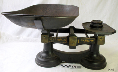
Equipment - Scale and weights, 1860-1900
The subject item was made in England by W&T Avery a British manufacturer of weights and weighing machines. The company was founded in the early 18th century and took the name W & T Avery in 1818. The undocumented origin of the company goes back to 1730 when James Ford established the business in the town of Digbeth. On Joseph Balden, the then company’s owner’s death in 1813 William and Thomas Avery took over his scale making business and in 1818 renamed it W & T Avery. The business rapidly expanded and in 1885 they owned three factories: the Atlas Works in West Bromwich, the Mill Lane Works in Birmingham and the Moat Lane Works in Digbeth. In 1891 the business became a limited company with a board of directors and in 1894 the shares were quoted on the London Stock Exchange. In 1895 the company bought the legendary Soho Foundry in Smethwick, a former steam engine factory owned by James Watt & Co. In 1897 the move was complete and the steam engine business was gradually converted to pure manufacture of weighing machines. The turn of the century was marked by managing director William Hipkins who was determined to broaden the renown of the Avery brand and transform the business into specialist manufacture of weighing machines. By 1914 the company occupied an area of 32,000m² and had some 3000 employees. In the inter-war period, the growth continued with the addition of specialized shops for cast parts, enamel paints and weighbridge assembly and the product range diversified into counting machines, testing machines, automatic packing machines and petrol pumps. During the second world war, the company also produced various types of heavy guns. At that time the site underwent severe damage from parachute mines and incendiary bombs. Then from 1931 to 1973, the company occupied the 18th-century Middlesex Sessions House in Clerkenwell as its headquarters. Changes in weighing machine technology after World War II led to the closure of the foundry, the introduction of electronic weighing with the simultaneous gradual disappearance of purely mechanical devices. The continued expansion was partly achieved through a series of acquisitions of other companies. After almost a century of national and international expansion, the company was taken over by GEC in 1979. Keith Hodgkinson, managing director at the time, completed the turn-around from mechanical to electronic weighing with a complete overhaul of the product range of retail sales of industrial platform scales. In 1993 GEC took over the Dutch-based company Berkel and the Avery-Berkel name was introduced. In 2000 the business was in turn acquired by the US-American company Weigh-Tronix, who already owned Salter, and is today operating as Avery Weigh-Tronix.An item used by grocers and merchants throughout the then British colonies of England to weigh store-bought goods around the mid to late 19th century. This item gives an insight into the daily lives of early colonial settlers and is a significant part of the era’s social history of the time.Balance scale and weights with removable dish, two round weights glued to tray 4oz and 8oz. Scales 'to weigh up to 28lb. Printed in gold on black labels each side "W & T AVERY LTD", "BIRMINGHAM" warrnambool, flagstaff-hill, flagstaff-hill-maritime-museum, maritime-museum, shipwreck-coast, flagstaff-hill-maritime-village, scale and weights, food preparation equipment, w t avery ltd, balance scale, grocers scales, james ford, william & thomas avery, birmingham uk -
 Flagstaff Hill Maritime Museum and Village
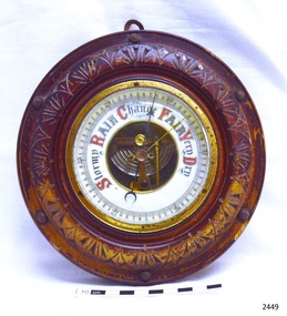
Instrument - Barometer, Early 20th century
A barometer is an instrument used for measuring atmosphere pressure thus determining weather changes.The first apparatus generally accepted as a barometer was that set up in Florence in 1644 by Evangelista Torricelli (1608–1647), a mathematician and physicist. Torricelli filled a glass tube with mercury, sealed it at one end, and inverted it with its open end in a dish of mercury. The level always fell a short way down the tube, then settled at a height of about thirty inches. He concluded correctly that the mercury column was sustained by the weight of the air pressing on the open surface of mercury, and further experiments convinced him that the space above the mercury in the tube was a vacuum. He noted that the level rose and fell with changing temperature, but he was unable to use his apparatus to measure variations in the weight of the atmosphere because he had not foreseen that temperature would affect the level of the mercury. News of this experiment circulated quickly among European scientists, who hastened to replicate the experiment. Torricelli's conclusions were not universally accepted because some disputed whether the air had weight, while both Aristotle and the Catholic Church denied the possibility of a vacuum. In France, the philosopher René Descartes (1596–1650) seems to have been the first person, probably in 1647, to attach a graduated scale to the tube so that he could record any changes attributable to the weather. At around this time Duke Ferdinand II of Tuscany organized the first short-lived meteorological network among scientists in other Italian cities, gathering observations of pressure, temperature, humidity, wind direction, and state of the sky.Theis barometer is an example of a household item from the early 20th century, used to determine the day's weather. The barometer is significant as an aid to human social, material and scientific development.Barometer, round, brass housing inset into carved wooden casing (lacquer mostly worn off). Decorative lettering for weather conditions "Stormy, Rain, Change, Fair, Very Dry". Workings are visible through opening in centre of dial. Indicator needle and another adjustable needle . Hook screwed into back of case.flagstaff hill, warrnambool, shipwrecked coast, flagstaff hill maritime museum, maritime museum, shipwreck coast, flagstaff hill maritime village, great ocean road, barometer, scientific instrument, weather forcasting instrument, weather gauge -
 Flagstaff Hill Maritime Museum and Village
Ship Log
Log Rotor or spinner of a taffrail Ship Log (261 in texta on back) with eyelet, joined on by spliced and whipped rope.flagstaff hill, warrnambool, shipwrecked-coast, flagstaff-hill, flagstaff-hill-maritime-museum, maritime-museum, shipwreck-coast, flagstaff-hill-maritime-village, log rotor, taffrail log -
 Flagstaff Hill Maritime Museum and Village
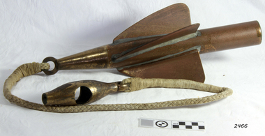
Ship Log, 1900-1920
The Excelsior IV Log is a nautical instrument for measuring a vessel’s speed and distance travelled. When navigating a ship it is essential to be able to estimate the boat’s speed and distance travelled to determine its position at sea. In times past the only way to measure a ship’s speed was to throw a wood log into the water and observe how fast it moved away from the ship. In the 16th century, the log was fastened to a rope knotted at set intervals. The log was thrown over the stern (back) of the vessel and a crew member counted the number of knots that were paid out in a set time. From this, they could estimate the speed of the vessel through the water. This was known as streaming the log and is also the derivation of the knot as a measurement of nautical speed. The Walker’s Excelsior Mark IV instrument was designed for smaller vessels, such as yachts, launches and fishing vessels. Historical: Thomas Walker & Son was internationally renowned in the manufacturing of ships logs, founding father , Thomas Walker (1805–1871), an engineer in Birmingham, patented a mechanical log in 1878 which was a recording instrument that attached to a rail at the stern of a vessel connected by a long cord with a rotor which was towed behind the ship. The instrument dial recorded the distance travelled. Thomas Walker first went into business to manufacture stoves at 58 Oxford Street Birmingham. Walker’s self-feeding stove was widely lauded at the Paris Exhibition of 1855, winning a prize medal and kick starting the first of many notable innovations for the Walker family's manufacturing business. However, it wasn’t until working on an earlier ship’s log model invented by his Uncle that Thomas Walker became interested in the further development of this device, used to ascertain a ship’s speed. Walker continued to improve on the common log for the company of Massey & Sons and these improvements were deemed revolutionary. This log became a firm favourite of the West India Association (British-based organisation promoting ties and trade with the British Caribbean), being the most common log in use for two generations. It took until 1861 for Thomas Walker and his son, Thomas Ferdinand Walker (1831-1921) to patent the first Walker log of many. Together, with the introduction of the A1 Harpoon Log two years later, they established the Walker Log Business as a force to be reckoned with. By the time of his passing in 1871, Thomas Walker Snr had not only founded a family business with considerable staying power but also instilled a tradition of public service. Having sat as a representative on the Birmingham Town Council for 15 years and played an active role in public works, he was soon given the nickname of ‘Blue Brick Walker’. Much like his father, Thomas Ferdinand Walker changed the face of the maritime industry. His patent of 1897, the ‘Cherub’ log, was a notable departure from the past providing a far more accurate reading and replacing the majority of logs of the age. They were the first to produce an electric log and the Walker factory was one of the first to introduce the 48 hour work week for employees. The ship log was invented and made by a significant marine instrument maker and innovator of machinery. It demonstrates the huge leap taken to improve navigational accuracy at sea with an instrument that was in use for decades.Ship's Taff Rail Log, rope attached. Walker's Excelsior IV Log model. Nautical miles dials: units and 10's. "Walker's Excelsior IV Log", "Made in England by Thomas Walker, Birmingham"flagstaff hill, warrnambool, shipwrecked-coast, flagstaff-hill, flagstaff-hill-maritime-museum, maritime-museum, shipwreck-coast, flagstaff-hill-maritime-village, log register, taff rail log, taffrail log, marine navigation, a1 harpoon log, cherub’ log, walker’s excelsior mark iv log, ship’s log instrument, mechanical ship’s log, measure ship’s speed, nautical instrument, navigation instrument, massey & sons, thomas walker, blue brick walker, thomas walker & son, thomas ferdinand walker, 48 hour work week -
 Flagstaff Hill Maritime Museum and Village
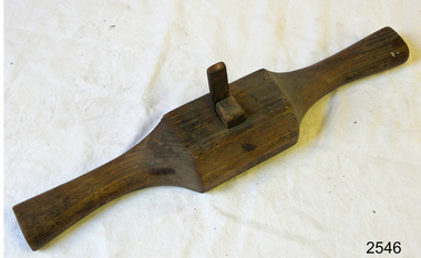
Spokeshave
Spokeshave, wooden & metal. Router blade. "J Glow" stamped on front and "R Crumble" on back.flagstaff hill, warrnambool, shipwrecked-coast, flagstaff-hill, flagstaff-hill-maritime-museum, maritime-museum, shipwreck-coast, flagstaff-hill-maritime-village -
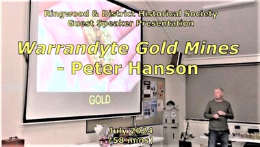 Ringwood and District Historical Society
Mixed media - Video, RDHS Guest Speaker Presentation - "Warrandyte Gold Mines" - Peter Hanson
Digitised video (2.73GB). Duration: 58 minutes. Recorded July, 2024. (Video is available for viewing at Ringwood & District Historical Society Archives by appointment)Guest Speaker, Peter Hanson grew up in Warrandyte surrounded by signs of gold mining activities including in his own back yard. In this presentation, Peter talks about the numerous diggings in the area, with images, maps and drawings of the mines, tunnels, shafts and structures above and below ground. -
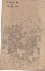 Ringwood and District Historical Society
Map, Borough of Ringwood, Victoria - c.1950s
A0-size (approx) linen-backed municipal engineer’s survey map of named streets and lot-numbered properties within Borough of Ringwood.Scale: 8 chains to 1 inch. -
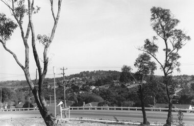
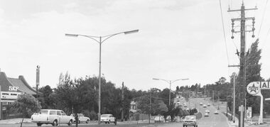 Ringwood and District Historical Society
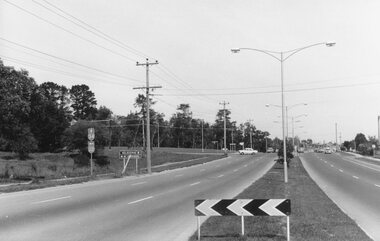
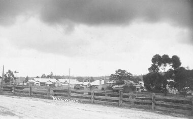
Photograph, Maroondah Highway East, Ringwood- 1971. Looking east towards Mt Dandenong Road
Black and white photographWritten on back of photograph: "Maroondah Highway, looking east towards Mt Dandenong Road turnoff past lake. 1971." -
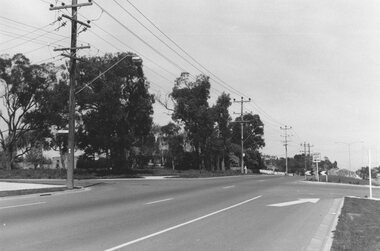
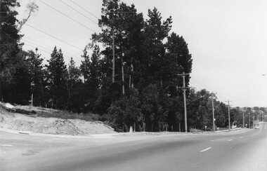
 Ringwood and District Historical Society
Photograph, Maroondah Highway East, Ringwood- 1965. Corner of Mt Dandenong Road before widening
Black and white photograph (3 separate images)Typed note on back of photograph: "M'dah Hwy, June 1965, before it was widened from Mt Dandenong on." -
 Ringwood and District Historical Society
Photograph, Maroondah Highway East, Ringwood- 1969. Looking west towards Ringwood from Everard Road
Black and white photographWritten on back of photograph: "Site of Cass's school, 1874. (1 acre left out of 5 acres). -
 Ringwood and District Historical Society
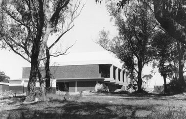
Photograph, Maroondah Highway East, Ringwood- 1969. New Civic Centre being built in Braeside Ave
Black and white photographWritten on back of photograph: "New municipal offices being built". -
 Ringwood and District Historical Society
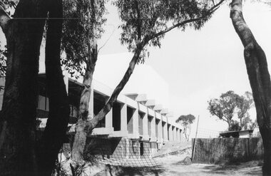
Photograph, Maroondah Highway East, Ringwood- 1969. New Civic Centre being built in Braeside Ave
Black and white photographWritten on back of photograph: "New municipal offices being built." -
 Ringwood and District Historical Society
Photograph, Maroondah Highway East, Ringwood- 1969. View looking north from Civic Centre towards Norwood High School
Black and white photographWritten on back of photograph: "Norwood High from Civic Centre, Nov 1969." -
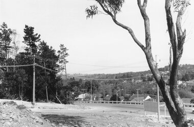
 Ringwood and District Historical Society
Photograph, Maroondah Highway East, Ringwood- 1969. Looking towards Mullum Road oval from Civic Centre
Black and white photographWritten on back of photograph: "From Civic Centre looking across Mullum Road oval, Nov 1969." -
 Ringwood and District Historical Society
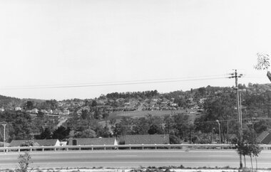
Photograph, Maroondah Highway East, Ringwood- 1969. View of Loughnan's Hill from Civic Centre
Black and white photographWritten on back of photograph: "Loughnan's Hill from Civic Centre. Nov 1969. -
 Ringwood and District Historical Society
Photograph, Maroondah Highway East, Ringwood- 1969. Looking north from Braeside Ave towards Loughnan's Hill
Black and white photographWritten on back of photograph: "From Civic Centre, Nov 1969. -
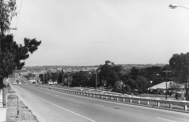 Ringwood and District Historical Society
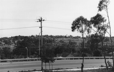
Photograph, Maroondah Highway East, Ringwood- 1969. Looking west towards Ringwood from Civic Centre
Black and white photographWritten on back of photograph: "Ringwood from Civic Centre." -
 Ringwood and District Historical Society
Photograph, Maroondah Highway East, Ringwood- 1969. Looking west towards Ringwood from Braeside Ave corner
Black and white photographWritten on back of photograph: "Nov 1969, cnr of Braeside Ave and Maroondah Highway." -
 Ringwood and District Historical Society
Photograph, Maroondah Highway East, Ringwood- 1969. Looking west towards Ringwood from Mt Dandenong Road intersection
Black and white photographWritten on back of photograph: "Nov 1969, Cnr Mt Dandenong Road and Maroondah Highway." -
 Ringwood and District Historical Society
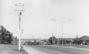
Photograph, Maroondah Highway East, Ringwood- 1969. Looking west towards Ringwood from Mt Dandenong Road
Black and white photographWritten on back of photograph: "Cnr Maroondah Highway and Mt Dandenong Road. Nov 1969." -
 Ringwood and District Historical Society
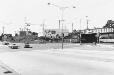
Photograph, Maroondah Highway East, Ringwood- 1969. Looking east from Warrandyte Road railway bridge
Black and white photographWritten on back of photograph: "May 1969, Site of first clock tower." -
 Ringwood and District Historical Society
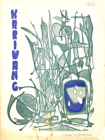
Magazine, Mitcham High School - Kariwang Magazine, 1963
Kariwang School Magazine from Mitcham High (subsequently renamed to Mullauna College), 1963. 32 pages. Coloured Cover, rest is Black and White. Back cover includes signatures from Form 2B students. -
 Ringwood and District Historical Society
Photograph, Maroondah Highway Central, Ringwood - Methodist Church & Sunday School, 1914
Black and white photograph/Postcard.Written on back of image: "Methodist Church and Sunday School from site of present church. 1914." -
 Ringwood and District Historical Society
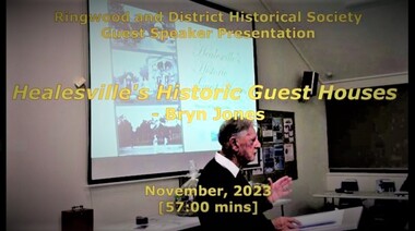
Mixed media - Video, RDHS Guest Speaker Presentation - "Healesville's Historic Guest Houses" - Bryn Jones
Digitised video (3.11GB). Duration: 57 minutes. Recorded November, 2023 (Video is available for viewing at Ringwood & District Historical Society Archives by appointment)Presenter: Bryn Jones, President of Healesville Historical Society, takes us back through the ages uncovering the origins and growth of Healesville's attraction as a local and international tourism destination, with a mix of tall tales and true stories associated with some of the guest house goings-on. -
 Ringwood and District Historical Society
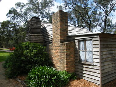
Photograph, Showing the exterior views of the facsimile of the miner's hut, located at the back of Ringwood Lake, from the original that once stood on Maroondah Highway in the 1870s onwards. The cottage was erected by the Ringwood City Council in conjunction with Ringwood Historical Research Group (now Ringwood & District Historical Society). Officially opened by Mayor Cr Pat Gotlib JP on 29th May 1983
Photographic record by Russ Haines, RDHS, in October 2008. -
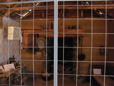
 Ringwood and District Historical Society
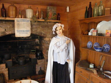
Photograph, Showing the interior views of the facsimile of the miner's hut, located at the back of Ringwood Lake, from the original that once stood on Maroondah Highway in the 1870s onwards. The cottage was erected by the Ringwood City Council in conjunction with Ringwood Historical Research Group (now Ringwood & District Historical Society). Officially opened by Mayor Cr Pat Gotlib JP on 29th May 1983
Photographic record by Russ Haines, RDHS, in October 2008. -
 Ringwood and District Historical Society
Photograph, Showing the tools and equipment rooms of the facsimile of the miner's hut, located at the back of Ringwood Lake, from the original that once stood on Maroondah Highway in the 1870s onwards. The cottage was erected by the Ringwood City Council in conjunction with Ringwood Historical Research Group (now Ringwood & District Historical Society). Officially opened by Mayor Cr Pat Gotlib JP on 29th May 1983
Photographic record by Russ Haines, RDHS, in October 2008.