Showing 404 items
matching topography
-
 Lakes Entrance Regional Historical Society (operating as Lakes Entrance History Centre & Museum)
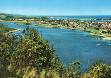
Postcard, Engelander John & Co Pty Ltd, 1980c
Panoramic view of Lakes Entrance taken by Melbourne firm for West Germany A.F.K. International Publishers of world's most famous beauty spotsColour postcard with serrated edge, of the township, situated between Cunninghame Arm and North Arm. Boats moored at jetties and beside boat ramps in North Arm. Photo taken from Kalimna Heights. Dredged sand dumped in North Arm bight. Lakes Entrance VictoriaLakes Entrance, Victoria, Australia (on back)boats and boating, waterways, topography -
 Lakes Entrance Regional Historical Society (operating as Lakes Entrance History Centre & Museum)
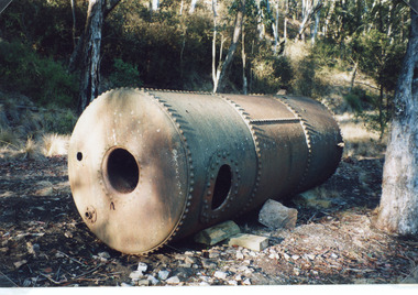
Photograph, Fish Marie, 1997
Date made 18 January 1997Colour photograph of a boiler which provided steam power to drive a winch at North Arm. Rock was transported from Mississippi Creek quarry along a tramline to North Arm where rock was transferred by steam powered winch to a barge which carried rock to the entrance. Lakes Entrance Victoriavegetation, boats and boating, topography -
 Lakes Entrance Regional Historical Society (operating as Lakes Entrance History Centre & Museum)
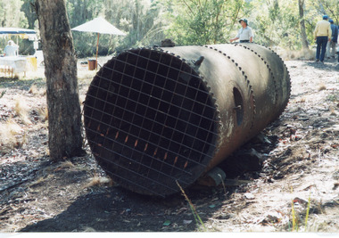
Photograph, Fish Marie, 1997
Date made 18 January 1997, for weekend trip 18 and 19 January 1997Colour photograph of the abandoned boiler at the North Arm. It shows a rusted steam boiler lying on its side, during 1920 and 1930 a steam crane was used to transfer rock from tram trucks to a barge for transport to the entrance. In background five people and shelters erected for information. Lakes Entrance Victoriavegetation, boats and boating, topography -
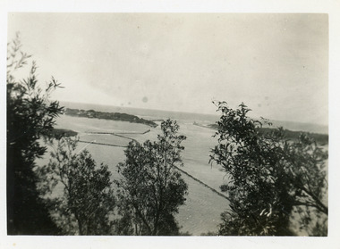
 Lakes Entrance Regional Historical Society (operating as Lakes Entrance History Centre & Museum)
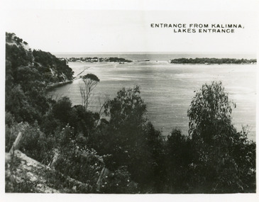
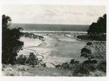
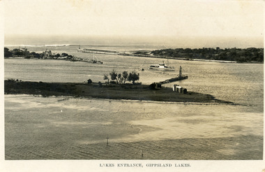
Postcard, 1935c
Also 2 identical small format postcardsBlack and white small format postcard taken from the cliff top at Kalimna. It shows the man made entrance through the hummocks, rock groynes, Jemmys Point cliff and natural vegetation in foreground. Lakes Entrance VictoriaEntrance from Kalimna, Lakes Entrancehouses, waterways, topography -
 Lakes Entrance Regional Historical Society (operating as Lakes Entrance History Centre & Museum)
Postcard, 1935c
Also small format identical postcard 6.5 x 8.5, very faded,|also small format photo, same view donated by D & M FletcherBlack and white small format postcard of the man made entrance to the Gippsland Lakes, taken from Jemmys Point. It shows the rock groynes beside Bullock Island, a barge in North Arm below Jemmys Point. Lakes Entrance VictoriaThe Entrance to Gippsland Lakeshouses, waterways, topography -
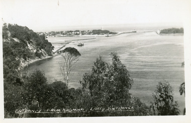
 Lakes Entrance Regional Historical Society (operating as Lakes Entrance History Centre & Museum)
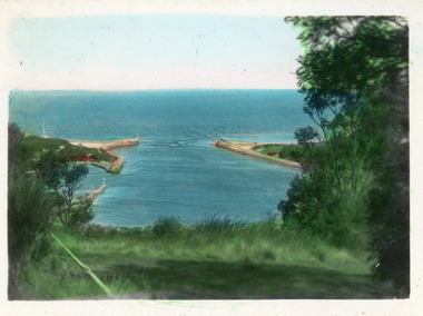
Postcard, Valentine Series, 1935c
Hand tinted postcard of the man-made entrance to the Gippsland Lakes, taken from Jemmys Point. It shows the rock groynes at Bullock Island and Entrance to North Arm, a barge in North Arm directly below Jemmys Point. Lakes Entrance Victoriaislands, waterways, topography -
 Lakes Entrance Regional Historical Society (operating as Lakes Entrance History Centre & Museum)
Postcard, The Lakes Studio, 1940c
1 other tinted Postcard in Spares BoxBlack and white postcard of the man-made entrance to the Gippsland Lakes, taken from Kalimna cliff top. It shows the jetty and residences at the New Works, rock groynes, barge in lake, steep cliff of Jemmys Point and natural vegetation of Kalimna in foreground. Lakes Entrance VictoriaEntrance from Kalimna, Lakes Entranceislands, waterways, topography -
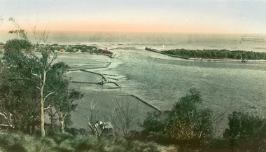
 Lakes Entrance Regional Historical Society (operating as Lakes Entrance History Centre & Museum)
Postcard, Bulmer H D, 1940c
Hand tinted small format postcard of the entrance to the Gippsland Lakes, taken from Jemmys Point. It shows the rock groynes at Bullock Island with dredged sand filling the basin between island and groyne. Lakes Entrance VictoriaThe Entranceislands, waterways, topography -
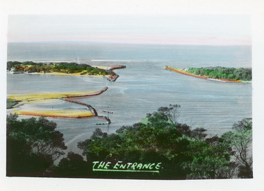
 Lakes Entrance Regional Historical Society (operating as Lakes Entrance History Centre & Museum)
Postcard, 1940c
2 x identical mini postcards collected 6.5 x 9|1 x photographic print copy 18.5 x 25Black and white small format postcard of the man-made entrance from Bass Strait to the Gippsland Lakes, taken from Jemmys Point. It shows the rock groynes at Bullock Island and North Arm entrance. Lakes Entrance Victoriaislands, waterways, topography -
 Lakes Entrance Regional Historical Society (operating as Lakes Entrance History Centre & Museum)
Postcard, 1940
Hand tinted small format postcard of the man-made entrance from Bass Strait to the Gippsland Lakes taken from Jemmys Point. It also shows the rock groynes at the entrance to Cunninghame Arm, and the grassy clearing atop Jemmys Point in the foreground. Lakes Entrance Victoriaislands, topography, waterways -
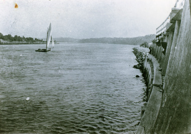
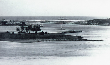
 Lakes Entrance Regional Historical Society (operating as Lakes Entrance History Centre & Museum)
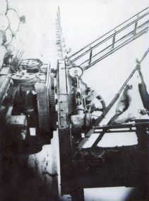
Photograph, 1910c
Also other copies, 10x13.5, 14.5x20, one of these has history of the travelling crane written on the back by Reg Schulz 11.6.1999, two of the prints have hand drawn enhancement lines.Black and white photograph of the historic travelling crane at New Works, built by Fulton Engineering Co. Melbourne in 1873 for John Carpenter, Contractor for Stage One of the construction of the entrance. Wooden piers also used by Coat Bros for Stage Two extensions in use to 1932. Lakes Entrance Victoriaislands, public works, topography -
 Lakes Entrance Regional Historical Society (operating as Lakes Entrance History Centre & Museum)
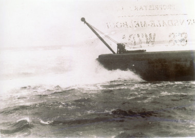
Photograph, 1910c
Also one other copy 9 x 12.5 cmBlack and white photograph showing ocean and southern end of western pier at entrance to Gippsland Lakes from Bass Strait, in heavy seas at Lakes Entrance, Victoria,boardwalk, navigation, topography -
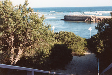 Lakes Entrance Regional Historical Society (operating as Lakes Entrance History Centre & Museum)
Photograph, Holding M, 1997
Date made July 1997Colour photograph of the western pier of the entrance to the Gippsland Lakes from Bass Strait, showing surf breaking on offshore bar, signal triangles, walking path and vegetation in foreground. Lakes Entrance VictoriaEntrance (on back)jetties, topography, waterways -
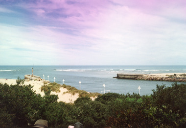
 Lakes Entrance Regional Historical Society (operating as Lakes Entrance History Centre & Museum)
Photograph, Holding M, 1997
Date made July 1997Colour photograph of the western pier of the entrance to the Gippsland Lakes, Lakes Entrance Victoriajetties, topography, waterways -
 Lakes Entrance Regional Historical Society (operating as Lakes Entrance History Centre & Museum)
Photograph, Holding M, 1997
Date made July 1997Colour photograph of the western pier of the entrance to the Gippsland Lakes, Lakes Entrance Victoriajetties, topography, waterways -
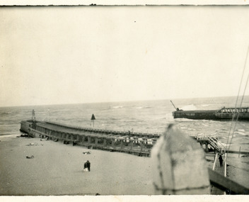 Lakes Entrance Regional Historical Society (operating as Lakes Entrance History Centre & Museum)
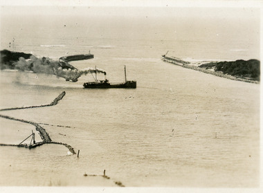
Photograph, 1919
Black and white photograph showing entrance to Gippsland Lakes from ocean - Bass Strait. Beach on left side of Eastern Pier. Lakes Entrance Victoriatopography, jetties, shipwrecks -
 Lakes Entrance Regional Historical Society (operating as Lakes Entrance History Centre & Museum)
Photograph, 1922
Black and white photograph showing entrance and piers, viewed from ocean end of pier looking north towards Kalimna, small sailing boat in entrance inside of Eastern Pier, on right amongst the timber piers is a man leaning out. Lakes Entrance Victoriatopography, jetties, waterways -
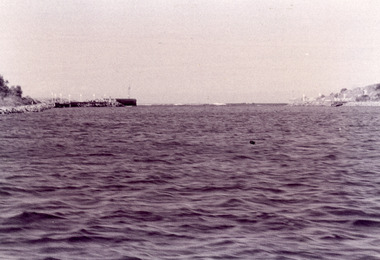 Lakes Entrance Regional Historical Society (operating as Lakes Entrance History Centre & Museum)
Photograph, Fish, Marie, 1995c
Black and white photograph showing view of entrance with eastern and western concrete and rock piers. Photo taken from boat in the channel. Waves breaking on bar at the entrance, at Lakes Entrance, Victoriaon back - The Entrance - taken from works boat, 1995jetties, topography, waterways -
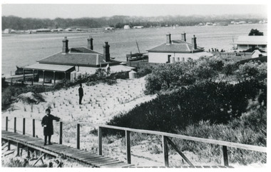 Lakes Entrance Regional Historical Society (operating as Lakes Entrance History Centre & Museum)
Photograph, 1900c
Also black and white copy 9 x 13 cmBlack and white photograph showing buildings on dunes. From left is harbour masters house, harbour engineers house, and Carpenters house. Child on boardwalk and newly planted marram grass on dune. Township across Cunninghame Arm. Lakes Entrance Victoriawaterways, topography, township -
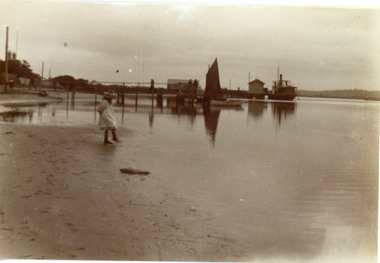 Lakes Entrance Regional Historical Society (operating as Lakes Entrance History Centre & Museum)
Photograph, Phillips, Miss L, 1900c
Two other copies 9 x 14 cm with the inscription The Business End New WorksBlack and white photograph showing beach in front of New Works houses, New Works wharf and sheds, steamer at end of wharf, small sail boat, with sail up, at end of PWD jetty, small child on beach, at Lakes Entrance, Victoria.topography, houses, waterfront -
 Lakes Entrance Regional Historical Society (operating as Lakes Entrance History Centre & Museum)
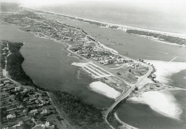
Photograph, 1975c
Black and white photograph of an aerial view of township and Kalimna Heights, showing the North Arm bridge and boat ramp, sand buildup in the lake system, boat harbour, sand hummocks and beach as far as Red Bluff. Lakes Entrance Victoriaaerial photograph, islands, topography -
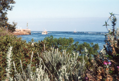
 Lakes Entrance Regional Historical Society (operating as Lakes Entrance History Centre & Museum)
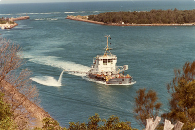
Photograph, Fraser, Ian, 1980 c
Colour photograph of the sand dredge, April Hamer, working inside the entrance off Bullock Island. Ocean in background, rock groynes of the entrance visible, a fishing boat coming through the entrance. Lakes Entrance Victoriawaterways, topography, ships and shipping -
 Lakes Entrance Regional Historical Society (operating as Lakes Entrance History Centre & Museum)
Postcard, 1910 c
Second copy same viewSmall format postcard showing coastal steamer S S Despatch leaving Cunninghame Arm, with entrance piers and rock groynes in view. Lakes Entrance VictoriaThe Piers from the lookout at Jemmys Point (on back)jetties, topography, transport -
 Lakes Entrance Regional Historical Society (operating as Lakes Entrance History Centre & Museum)
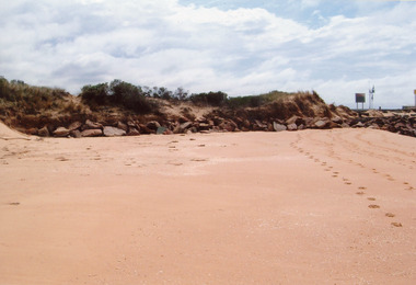
Photograph, 2009
Date made January 2009Colour photograph showing western side of western pier. Rocks extend from end of pier along base of sand dunes, some vegetation on dunes. Signs and lights on piers. Lakes Entrance Victoriajetties, topography, transport -
 Lakes Entrance Regional Historical Society (operating as Lakes Entrance History Centre & Museum)
Photograph, 1915c
On back of original 'To Rit with love from Arthur' (Arthur Seagrove - Head Teacher, Johnsonville Primary School - 1920)Black and white photograph of Bullock Island and the man-made entrance from Bass Strait. It shows the Western end of Bullock Island, some natural vegetation, jetty and timber groynes, trading vessel standing outside entrance. Lakes Entrance Victoriawaterways, islands, topography -
 Lakes Entrance Regional Historical Society (operating as Lakes Entrance History Centre & Museum)
Postcard, Bulmer H D, 1923c
Also same image|Faded copy 10x15|Black and White 12x17.5|Black and White 20x28.5Black and white postcard of the entrance to the Gippsland Lakes, showing buildings at New Works, cranes on ends of piers, jetty and bathing boxes on bullock Island, steamer passing island. Lakes Entrance VictoriaLakes Entrance, Gippsland Lakeswaterways, islands, topography -
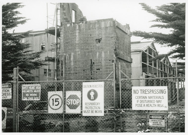 Lakes Entrance Regional Historical Society (operating as Lakes Entrance History Centre & Museum)
Photograph, Lakes Post Newspaper, 1995
This image appeared in Lakes Post 21 May 1995Black and white photograph of Pecks fish processing factory on Bullock Island, during demolition. It shows a building clad with asbestos cement sheets, and a partly demolished brick tower, enclosed by cyclone wire fence and gates with eight warning signs attached. Health and safety issues were paramount during demolition. Lakes Entrance Victoriaislands, machinery, topography -
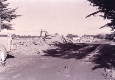 Lakes Entrance Regional Historical Society (operating as Lakes Entrance History Centre & Museum)
Photograph, Fish Marie, 1995c
Black and white photograph, heavy machinery clearing the site of Pecks fish processing factory on Bullock Island, showing piles of broken concrete ready for removal. Lakes Entrance Victoriaislands, waterways, topography -
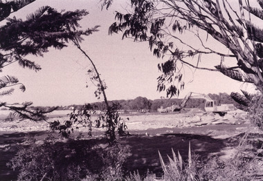 Lakes Entrance Regional Historical Society (operating as Lakes Entrance History Centre & Museum)
Photograph, Fish Marie, 2005c
Black and white photograph showing heavy machinery clearing the site of Pecks fish processing factory on Bullock Island, photo also shows dumped sand on island and Kalimna Heights in background. Lakes Entrance Victoriaislands, waterways, topography -
 Lakes Entrance Regional Historical Society (operating as Lakes Entrance History Centre & Museum)
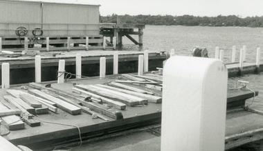
Photograph, Lakes Post Newspaper, 1995
Date made November 1995Black and white photograph of the Public Works jetty on Bullock Island. It shows the jetty complex built approximately 1970's, Cunninghame Arm and scrubby vegetation on southern shore. Lakes Entrance Victoriaislands, education, topography