Showing 1960 items
matching tourists
-
 Halls Gap & Grampians Historical Society
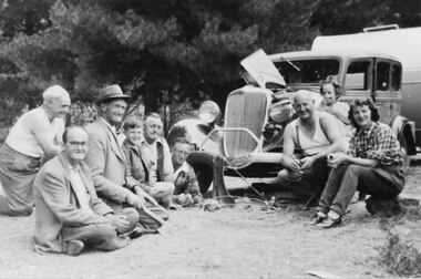
Photograph - B/W, C 1946
... Tourists ...The woman on the right is Mrs Nally, nee Lawson. The man next to her is her husband Pat Nally (a policeman from Port Fairy). The young girl is Patricia Nally. The man lying on the ground next to the car is William Parfett. next to him is (?) Lawson, the boy is either David or Robert Parfett (they were twins). The photo was taken at Zumsteins Campground.The photo shows a group of people (six men, one boy, one woman and one girl) seated and kneeling around a car and caravan. The car bonnet it raised and there is a man's hat sitting on the right headlight.people, tourists -
 Stawell Historical Society Inc
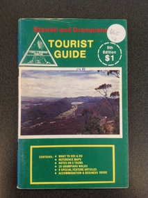
Book, Stawell & Grampians Tourist Council, Stawell & Grampians Visitor Guide & Directory 1981, 1981
Tourist Guide to Stawell and The GrampiansGreen paper cover with Red, Yellow & White Print. Centre of page is a colour photo of the Grampians. Red Test. "Stawell and Grampians" inside white triangle "Stawell & Grampians Promotion". Yellow Print Tourist Guide" Inside a white segmented circle, white Print "5th Editon $1" Inside Yellow outlined rectangle with yellow Print. "Contains: WHAT TO SEE & DO REFERENCE MAPS NOTES ON 5 TOURS 28 GRAMPIANS WALKS 9 SPECIAL FEATURE ATICLES ACOMMODATION & BUSINESS GUIDEstawell tourism -
 Marysville & District Historical Society
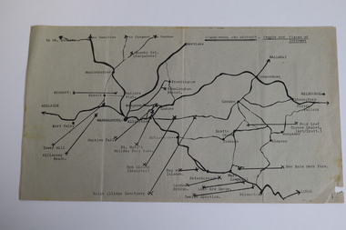
Map (Item) - Tourist and business map, Narbethong Community and Tourism Group, the Gateway TOURIST AND BUSINESS MAP, 08-2009
A tourist and business map of Narbethong, Buxton, and Taggerty. This map was produced by the Narbethong Community and Tourism Group Inc in August 2009. It was produced to promote the natural attractions, adventure activities, and food trail from the Black Spur, through Narbethong, Buxton, and Taggerty.A tourist and business map of Narbethong, Buxton and Taggerty.This publication has been produced by the Narbethong Community and Tourism Group Inc./ (NCTG) The information provided in this publication has been supplied by the individual/ members. NCTG takes no responsibility for its accuracy./ August 2009narbethong, buxton, taggerty, victoria, australia, tourist and business map, the gateway tourist and business map, black spur motel & caravan park, woodlands rainforest retreat, chestnut glade, black spur inn, wombat cottage, abbey lake luxury b&b spa cottages, camp narbethong, marapana farm stay b&b, mantirri b&b, little dene garden cottages, nareen cabins, silverstream b&b cottages, buxton hotel motel, south cathedral farm luxury b&b cottages, cathedral view b&b retreat, kingbilli country estate, cathedral valley farm, pinjarra gardens, willowbank at taggerty, sarsens rest, yarrolyn caravan park, danico design counted cross stitch, things of sand & stone, buxton zoo nursery, safetrek 4wd services, mystic mountains ski hire & outdoors, pnl 4wdriving, buxton trout and salmon farm, buxton bait and tackle, black spur roadhouse, tudor lodge service station roadhouse & ski hire, buxton roadhouse, buxton p.o. general store, igloo roadhouse, henry v111 manor house, buxton hotel, butters cafe, wagtail wines, little river wines, narby eggs, marapana agistment park, carmyle farm, hazelwood hazelnuts, cathedral view naturall therapies, cre8ing growth, linda hailey, naby cabinets, gb timber, narbethong timber & trading, rb automotive repairs, buxton car care, martyn slade building design, taggerty vet clinic -
 Warrnambool and District Historical Society Inc.
Map - Tourist Map Collection: Warrnambool & District Tourist Maps, Philprint, Warrnambool
This is a diverse collection of Tourist Maps for the Warrnambool & District area. [.1] From information on this guide it dates from the mid 1970's. It appears to not have been commercially printed and includes details of attractions no longer operating in Warrnambool such as Warrnambool Aquarium and the Oasis Reptile Park and Zoo. [.2] Commercially printed Warrnambool tourist map (c mid 1980's) surrounded by advertisements for local businesses. [.3] Commercial printed December 1991 tourist map of Warrnambool and District includes a competition entry form [.4] Commercially printed tourist map aimed at children [.5] Walking map of Warrnambool and District [.6] Commercially printed Warrnambool tourist map (c mid 1980's) surrounded by advertisements for local businesses. This collection of maps from the mid 1970's to early 1990's gives an insight into what was available to assist tourists find their way around Warrnambool and District. They include advertisements for business operating during this period and include lists of available accommodation, eateries, and tourist attractions.[.1] Tourist Attractions In and Around Warrnambool two foolscap pages with two sides of type written information of local and district attractions. There is a Warrnambool City map with points of interest marked and a hand drawn district map; [.2]Commercially printed grid map of Warrnambool City surrounded by advertisements from local businesses. Reverse side has a district map and a map of the Warrnambool CBD surrounded by advertising. [.3] Brochure including small grid maps of Warrnambool and district listing accommodation providers and places of interest. Stylised blue & bright green design of Norfolk pines and sea. [.4] Children's treasure hunt map to Warrnambool There are two examples, one with blue edging (Jan 1986) and one with red edging (Aug 1993) Both have a circular logo with a stylised whale and lighthouse [.5] Walking maps of Warrnambool blue printed photo of four tourists walking coastline on the front cover. [.6] Commercially printed grid map of Warrnambool with a bright yellow inset of Warrnambool CBD main shopping centre. The map is surrounded by advertising for local businesses.warrnambool, tourist maps, warrnambool businesses, warrnambool accommodation -
 Lakes Entrance Historical Society
Photograph - Tourist Ferry Lakes Entrance, 1920 c
Black and white photograph of thirteen tourists in open motor boat tourist ferry Lakes Entrance Victoriatourism, boats and boating, people -
 Kiewa Valley Historical Society
Postcard Circa 1950, Snow Plough, Bogong High Plain,5,500 Feet Kiewa Hydro-Electric Project, Circa 1950
This postcard was produced in the 1950's for the tourist trade in the Kiewa Valley and Alpine region. It encompasses the period when the State of Victoria was pressured by the ever increasing demand by industry and its population for electricity supplies. Hydro electricity was seen as an untapped natural resource to quench this demand. The Victorian Alps and the rivers flowing into its valleys was ideal for the construction of the Kiewa Hydro Electricity Scheme. The late 1940's saw the development of this scheme and the changing of sections of alpine landscape is covered by this and other postcards/pictures (tourists, construction workers, and established rural populations). This period in time was before the established wildlife and forest/nature groups became political activist who changed legislative acts to protect the environment. This rural region (Kiewa Valley/alpine plains) was at most only significant to a smaller group of winter sports, summer hikers/horse riders and rural farmers/graziers. The numbers of tourists and the increase in the local resident population was boosted by the construction of the Hydro Electricity Scheme. This influx to the regional population resulted in a corresponding diversity in services and brought about an environment that responded to a growing level of tourists and thereby permitting this industry to grow more rapidly than it would have naturally. This postcard details an attraction to the "cleaner" method of providing electricity. This postcard was purchased in 1950 by a surveyor at Landford's Gap. This item is a black and white photograph(professional) of a panoramic view of a snow plough clearing the unsealed road in 1950.This postcard is on quality paper and the reproduction of the picture is of a high standard.For other "tourist" postcards see 0480 (A) -(F) for other photos of similar postcards. kiewa valley tourism, victorian alps, alternate energy supplies, alpine population growth, secv, snow plough -
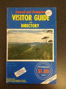 Stawell Historical Society Inc
Book, Stawell & Grampians Tourist Council, Stawell & Grampians Visitor Guide & Directory 1979, 1979
Tourist Guide to Stawell and the GrampiansBlue cover with red, yellow & blue print. Picture of the Grampians in center of cover.In Red Print Stawell and Grampians. In Yellow Print Visitor Guide and Directory. In Blue Print 4th Edition Souvenir Edition. In White Inset "Containing Offical Walking Maps. Bottom Right in Yellow Print " Issued by the Stawell and Grampians Tourist and Promotion Advisory Council. In two white circle with white and Red print the Price in Red "Recommended $1.00 Price" Bottom Right at 45 degrees in blue print Concession Coupons Inside.stawell tourism -
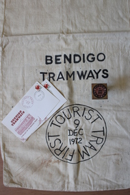 Bendigo Tramways (managed by the Bendigo Heritage Attractions)
Mail Bag, 1972
These items signify the launch of the Vintage Talking Tram tourist project by The Bendigo Trust for Bendigo Tramways.Calico mail bag, rubber stamp and stamped envelopes. mail bag: Bendigo Tramways First Tourist Tram 9 Dec 1972 rubber stamp: Bendigo Tramways First Tourist Tram 9 Dec 1972 envelopes: Bendigo Tramways First Tourist Tram 9 Dec 1972 -
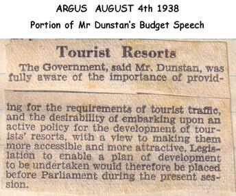 Phillip Island and District Historical Society Inc.
Newspaper clippings, 04/08/1938
Article in The ArgusArticle on requirements of Tourist trafficlocal history, documents, newspapers, tourist traffic phillip island, black & white newspaper clipping -
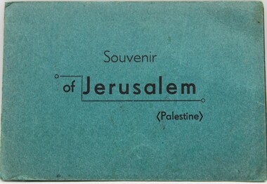 Ringwood RSL Sub-Branch
Memorabilia - Soldiering book- Jerusalum
letter to home and tourist book -
 Bendigo Historical Society Inc.
Document - AULSEBROOK COLLECTION: TOURIST PROMOTION REPORT 1967, 1967
Aulsebrook Collection: Tourist Promotion Report 1967. -4 pages, typed. -Report made by two Sub Committees related to Mining (mine museum etc) and Tourist Promotion (Tourist promotion for Bendigo area) -
 Bendigo Military Museum
Poster - POSTCARDS, PHOTOGRAPHIC WW1, 1), .2), .3), .5), .8), .10) & .11) Brighton Palace Series, c.1916-1919
Photographic postcards of Brighton & Folkestone, England sent home in WWI.Postcards B & W of Southern England.Descriptions of tourist sites in Southern England, some with handwriting.photography-photographs, military history -
 Bendigo Historical Society Inc.
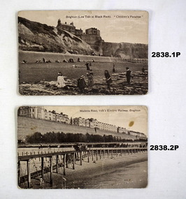
Photograph - PETHARD COLLECTION: PHOTOGRAPH RESO TOUR
George Pethard Collection including references to Taraxale Brewing Company Pty brown covered 29x19mm photographic album bound with gold string / 52 black and white Photographs of Reso tour to central Australia and Northern Territory / includes Aboriginal camps , camel trains / landscapes , war cemetery at Adelaide River / May 13- June 13 1947 / the 40 members of the party are also named includes: George Pethard / Aboriginal camp , Jay Creek consisting of makeshift tents / crowd playing 'Two Up ' Photo of the ship 'Meggs' at Darwin / Manton Dam - Darwin's water supply photo. Reso Tour to Central Australia and Northern Territory.Roy Dunstan Publicity and Tourist services Victoria Railwaysphotograph, person, male, george pethard / taraxale brewing company pty ltd / aboriginal camps / camel trains / war cemetary at adelaide river photo of the ship 'meggs' at darwin / manton dam - darwin's water supply photo -
 Glenelg Shire Council Cultural Collection
Document - Portland Tourist Guide, E. DAVIS & SONS Pty Ltd, n.d
Sixteen page tourist guide to Portland, similar set-up to 8199, but image of Tourist Information Centre on front cover. -
 Marysville & District Historical Society
Ephemera (Item) - Circular, Jack Haycraft, Marysville Tourist & Progress Association, 17-15-1965
A circular produced by the Marysville Tourist & Progress Association requesting assistance from members in raising funds to promote tourism in the district. This circular was sent to members in September 1965 to inform members as to which members had paid the requested funds, how much they had paid, and which members had outstanding payments still to be made. The circular was sent to encourage members to support the endeavour to raise funds to enable the town of Marysville to promote tourism in the district. A circular produced by the Marysville Tourist & Progress Association requesting assistance from members in raising funds to promote tourism in the district. The Association was formed in November 1907 to promote tourism within the area. This included the physical creation of signage, parklands, roads and walks to various attractions. marysville, victoria, marysville tourist & progress association, marysville and district tourist and progress association, circular -
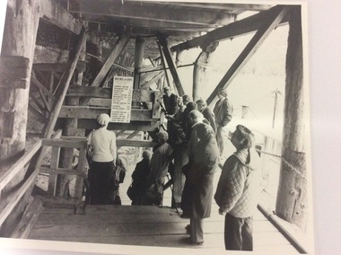 Port of Echuca
3 black and white photographs, 20/09/1984
This photograph shows the wharf in the 1980's. It is the early days of tourism, and shows Helen Coulson, dressed in period costume guiding the tourists. The sign shows distances from Echuca to significant sites on the Murray River in miles, as that was the way distance was calculated in the 1870's. The sign is no longer there.This photograph shows Helen Coulson as a tour guide. Helen was the first Manager of the Port of Echuca from the mid 1970's. The tourism industry was still in it's infancy and Helen was a strong supporter of the Port. The photograph also shows the structure of the wharf as the photograph is taken on the lower level.3 black and white photographs of tourists under the wharf with Helen Coulson, dressed in period costume, as a tour guide. The structure of the wharf can be clearly seen. Also a sign with towns showing their distance from Echuca, in miles, can clearly be seen. The three photographs are identical. There are no inscriptions or markings.helen coulson, echuca wharf., tourism, murray river, rosel, mike -
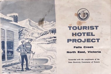 Falls Creek Historical Society
Document - Tourist Hotel Project
State Electricity Commission (SEC) outlined details of a site available for the development of a Tourist Hotel Project in Falls Creek in late 1962/3. SEC estimated that by the winter of 1963 Falls Creek Village would be able to accommodate 500 persons. The site for development was up to 2½ acres adjacent to the Upper Kiewa Valley Road. It envisaged a building able to accommodate about 100 guests. The successful developer would be granted a lease for 45 years at a rent of £300 per annum. Written applications for the lease were to be submitted by 31st March 1963.This item is significant because it documents plans made by the State Electricity Commission to develop the Falls Creek Tourist Area. A folder with a black and white image of skiers outside a hotel on the left. The logo of the State Electricity Commission and text is on the right half of the folder.On right half of cover: Logo of the State Electricity Commission TOURIST HOTEL PROJECT Falls Creek / North East Victoria Forwarded with the compliments of the State Electricity Commission of Victoriafalls creek tourist area, hotel development falls creek, falls creek projects 1963 -
 Kew Historical Society Inc
Photograph - Hicks' Cruises ticket seller at Princess Bridge, c.1953
Commercially-operated boat tours on the Maribyrnong and Yarra Rivers in Melbourne were a major tourist attraction, especially in the first half of the twentieth century. A number of companies ran ferries and motor-launches to locations such as the Riverview Tea Gardens (1909-1947) at Ascot Vale, and the Hawthorn Tea Gardens on the corner of Power Street and Riversdale Road. One of the families which ran these services was Hicks Bros, which from circa 1921 operated a ferry service from Princess Walk (Melbourne) to Studley Park. This is one of a series of 17 black and white undated photographic proofs donated to the Kew Historical Society in 2013 by the Queenscliffe Historical Museum. The series includes images of individuals, tea rooms, ferries, motor launches, ocean liners and tugs. In 1953, the owner of Hicks Bros was involved in an inquest into the drowning of a Ukrainian tourist on a ferry operated by Melbourne Ferries, a rival firm. In published reports of the inquest, reference is made to a number of photographs taken by Robert Irvine Atchison, part-owner of Hicks Bros. As the reverse of the photographs indicates copyright is held by the State of Victoria, the collection may have derived from that year.Closeup photograph of a ticket seller touting for business for a tourist ferry moored at Princess Bridge The sign on the boat identifies the destination of the ferry as 'Studley Park via Hawthorn Tea Gardens'. The ferry is empty of passengers.hicks' cruises, tourism -- melbourne (vic.), river yarra, studley park, hawthorn tea gardens -
 Warrnambool and District Historical Society Inc.
Pamphlet (Collection) - Warrnambool Tourist Maps, Warrnambool City Council, 1975 to 2002
Warrnambool Tourist Maps collected over the years by Warrnambool Historical Society membersPreservation of local maps for historical purposesEnclosed in A4 size plastic envelopes in an A4 size archival box and numbered and catalogued according to the date of acquisition.This collection has 16 pamphlets containing maps of Warrnambool and district and some accompanying printed materialwarrnambool tourism, city of warrnambool, shipwreck coast tourismwarrnambool tourism, city of warrnambool, shipwreck coast tourism -
Glenelg Shire Council Cultural Collection
Booklet - Tourist Booklet - Portland Nature's Ideal Resort, c. 1910
Tourist booklet, 'an illustrated guide for tourists'. Brown covers, red and black print, booklet is white, black print and photos, 20 pages -
Glenelg Shire Council Cultural Collection
Booklet - Booklet Brochure - Tourist Information Portland info & advertising, E Davis & Sons PTY LTD Portland, 1980s
Tourist information brochure, 'Welcome to Portland' 20 page booklet, information and advertising. Front cover has image of Tourist Information Centre -
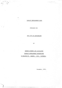 Old Castlemaine Schoolboys Association Inc.
Document, George Hibbert and Associates, The Hibbert Report
TOURIST DEVELOPMENT PLAN PREPARED FOR THE CITY OF CASTLEMAINE BY GEORGE HIBBERT AND ASSOCIATES TOURIST DEVELOPMENT ENTERPRISES 53 MILTON ST. ELWOOD. 3184. VICTORIA. November, 1972. -
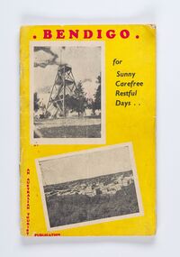 City of Greater Bendigo - Civic Collection
Booklet, Co-operative Press, Bendigo for Sunny Carefree Restful Days, 1947
A promotional publication to attract and encourage tourism to the district. Includes information about geographic location, climate and attractions. Businesses advertising is very eclectic and includes fashion houses, breweries, cafes and the School of Mines and Industry.Thirty six booklet promoting popular sites, events and businesses in Bendigo. Printed in three colour. Right hand page has the slogan BENDIGO "For That Dreamed - of Holiday" with images and text. Left page has full and half page advertisements for businesses, buildings and events.Bendigo / For / Sunny / Carefree / Restful / Days .../ An Australian Tourist / Publicationcity of greater bendigo commerce, city of greater bendigo events, city of greater bendigo tourism, making a nation -
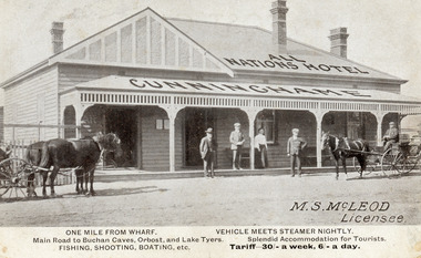 Lakes Entrance Historical Society
Postcard - All Nations Hotel, 1910c
M.S McLeod, Licensee. One mile from wharf, Main Road to Buchan Caves, Orbost and Lake Tyers. Fishing, Shooting, Boating. Vehicle meets steamer nightly. Splendid Accommodation for Tourists. Tariff 30/- a week, 6/- a day.This is the before paired photograph used in the 150 year, Lakes Entrance 1858-2008 display.Also one 12 x 16 framed photograph used in room displayBlack and white postcard of All Nations Hotel, Cunninghame, showing weatherboard building, hipped roof with gable on left side. Roofed veranda across front. Two doors and two sash windows at front. Two bench seats on veranda. Three chimneys. Two horse drawn carriages standing on road, three men and one woman standing before the hotel. Lakes Entrance VictoriaOne Mile from Wharf. Main Road to Buchan Caves, Orbost and Lake Tyers Fishing, Shooting, Boating etc. Vehicle Meets Steamer Nightly. Splendid Accommodation for Tourists. Tariff 30/- a week. 6/- a dayhouses, architecture, transport, room display -
 Marysville & District Historical Society
Ephemera (Item) - Circular, Jack Haycraft, Marysville Tourist & Progress Association, 17-11-1964
A circular produced by the Marysville Tourist & Progress Association requesting assistance from members in raising funds to promote tourism in the district. The circular was sent to the following members: Marylands Guest House, Kerami Guest House, The Cumberland, Marylyn Guest House, Mt. Kitchener House, Kooringa Guest House, Barton Bros, Marysville Theatre, Marysville Garage, F. Schulthess and, K. McKenzie Taxi Service. A Sub-committee was then formed with the following members: Mr. F. Fiske, Mr. J. Haycraft, Mr. G. Cuzens, Mr. J. Darmody, and, Mr. M. Hull to administer the funds. A circular produced by the Marysville Tourist & Progress Association requesting assistance from members in raising funds to promote tourism in the district. The Association was formed in November 1907 to promote tourism within the area. This included the physical creation of signage, parklands, roads and walks to various attractions. marysville, victoria, marysville tourist & progress association, marysville and district tourist and progress association, circular -
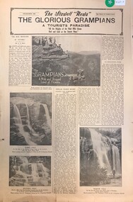 Stawell Historical Society Inc
Archive - Newspaper Supplement, The Stawell News: The Glourious Grampians A Tourist Paradise 1938
Grampians LandmarksFour (4) Pages on Tourist Sights in the Grampianstourism -
Hand Tool Preservation Association of Australia Inc
Cuckoo clock
This item is part of the Thomas Caine Tool Collection, owned by The National Trust of Australia (Victoria) and curated by the Hand Tools Preservation Association of Australia.cuckoo clock, 1 of 4, different tourist -
Hand Tool Preservation Association of Australia Inc
Cuckoo clock
This item is part of the Thomas Caine Tool Collection, owned by The National Trust of Australia (Victoria) and curated by the Hand Tools Preservation Association of Australia.cuckoo clock, 2 of 4, different tourist -
Hand Tool Preservation Association of Australia Inc
Cuckoo clock
This item is part of the Thomas Caine Tool Collection, owned by The National Trust of Australia (Victoria) and curated by the Hand Tools Preservation Association of Australia.cuckoo clock, 3 of 4, different tourist -
Hand Tool Preservation Association of Australia Inc
Cuckoo clock
This item is part of the Thomas Caine Tool Collection, owned by The National Trust of Australia (Victoria) and curated by the Hand Tools Preservation Association of Australia.cuckoo clock, 4 of 4, different tourist