Showing 672 items matching "tunnels"
-
 Coal Creek Community Park & Museum
Mine Map
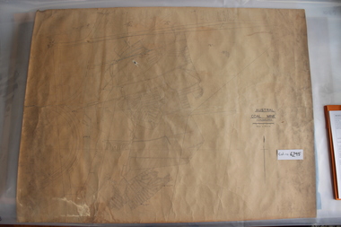
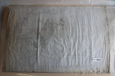
6295.1 - Large map of Korumburra coal mine; shows seams, tunnels, railways, roads and Leura Creek. There is a grid over the main area and a scale legend. -
 National Vietnam Veterans Museum (NVVM)
Poster - Poster, Information Board, Behind The Wire
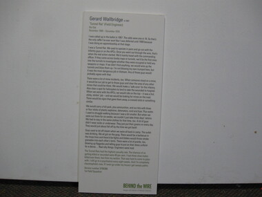
A Storybord on Gerard Wallbridge "Tunnel Rat" (Field engineer) Nui Dat, December 1969 - December 1970. Service Number 3796386, 1st Field Squadronstoryboard, 1st field squadron, nui dat, behind the wire, tunnel rats, gerard wallbridge -
 National Vietnam Veterans Museum (NVVM)
Poster - Poster, Information Board, Behind The Wire
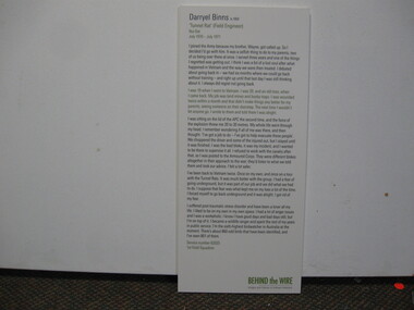
Storyboard of Darryel Binns "Tunnel Rat" (Field Engineer) Nui Dat, July 1970 - July 1971. Service Number 62025, 1st Field Squadronstoryboard, darryel binns, nui dat, tunnel rats, 1st field squadron -
 Kiewa Valley Historical Society
Plans - Southern Hydro - Bogong Power Development
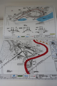
Southern Hydro owned the Kiewa Hydro Electric Scheme in May 2006 when these plans were created. The Site No. 1 and Site No. 2 are part of the Bogong Power Development Bogong Power Development is part of the Kiewa Hydro Electric SchemeLaminated A3 plans mostly black and white but with a little color and surrounded by a grid.(Also see KVHS 1439) 1. Tunnel and Civil works / Commissioners Lodge Site Plan 1: Site No. 1 / TBN /Water /Supply / Reservoir Site 2. Tunnel and Civil Works / Pedestrian Diversion Access Paths / and Tracks: Site No. 2 / Lake Guy Site / Bogong Victoriabogong power development, southern hydro 2006 -
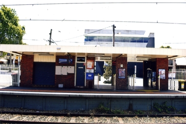 Whitehorse Historical Society Inc.
Photograph, Blackburn Railway Station, 2012
See NP3406Coloured photograph of the railway line near the Blackburn station, heading west towards the 'city Entry is from Railway Road and South Parade via a tunnel - 2012blackburn railway station, railways -
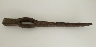 Federation University Historical Collection
Tool - Picks, Miner's Pick
This type of pick used in mining and tunnelling.Metal, slightly curved sharp end with hammerable top end. Open hole for handle which would have been wood.mining, pick, tools, trades -
 Bendigo Historical Society Inc.
Photograph - RALPH BIRRELL COLLECTION: TUNNEL BELOW THE CEMENT, WHITE HILLS
Colour photograph: 'showing tunnels below the cement where the miners chipped the undersurface to get the gold The thickness of the cement can be seen' Loose sand and gravel above the cement has already been removed. Image shows layer of cement, tunnel visible on LH side, clay and gravel in front. (see Mosaic 4400.220 for detailed information regarding the White Hills, written by Dr. Ralph Birrell)bendigo, mining, white hills -
 Bendigo Historical Society Inc.
Photograph - RALPH BIRRELL COLLECTION: WHITE HILLS MINING SITE
Colour photograph 'showing tunnels below the cement where the miners chipped the undersurface to get the gold The thickness of the cement can be seen'. Loose sand and gravel above the cement has already been removed. Image shows mining tunnel visible going in under the cement. White clay in foreground. (see Mosaic 4400.220 for detailed information regarding the White Hills, written by Dr. Ralph Birrell)bendigo, mining, white hills -
 National Vietnam Veterans Museum (NVVM)
Photograph, Behind The Wire
A black and white photograph Gerard Wallbridge "Tunnel Rat" (Field engineer) Nui Dat, December 1969 - December 1970. Service Number 3796386, 1st Field Squadronbehind the wire, photograph, gerard wallbridge, tunnel rats, 1st field squadron, nui dat -
 National Vietnam Veterans Museum (NVVM)
Photograph, Behind The Wire
A black and white photograph of Darryel Binns "Tunnel Rat" (Field Engineer) Nui Dat, July 1970 - July 1971. Service Number 62025, 1st Field Squadronphotograph, behind the wire, darryel binns, tunnel rats, nui dat, 1st field squadron -
 Whitehorse Historical Society Inc.
Article, Tunnel vision, 2005
Article on the progress of excavation works on Eastlink's Mullum Mullum Valley tunnel, and the visit of Premier Steve Bracks and Transport Minister Peter Batchelor to the site.Article on the progress of excavation works on Eastlink's Mullum Mullum Valley tunnel, and the visit of Premier Steve Bracks and Transport Minister Peter Batchelor to the site. Photos of site and visitors.Article on the progress of excavation works on Eastlink's Mullum Mullum Valley tunnel, and the visit of Premier Steve Bracks and Transport Minister Peter Batchelor to the site. eastern freeway extension, mullum mullum creek, eastlink -
 Wodonga & District Historical Society Inc
Album - Hume Reservoir Australia Album - Core wall with drainage tunnel and earth embankment in progress in Victoria, June 1924
This set of photos is from a leather bound album bearing the inscription "HUME RESERVOIR AUSTRALIA" plus 'The Rt. Hon. L. C. M. S. Amery, P. C., M .P.' all inscribed in gold. It was presented to The Rt. Hon. L. C. M. S. Amery, P. C., M. P, Secretary of State for Dominion Affairs on the occasion of his visit to the Hume Reservoir on 2nd November 1927. This album is of local and national significance as it documents the planning and development of the Hume Reservoir up to 1927. It was the largest water reservoir in the British Empire. The album records the pioneering engineering work that went into its construction.DEPARTMENT OF PUBLIC WORKS, N.S.W. RIVER MURRAY WATERS SCHEME. HUME RESERVOIR. 14. Core wall with drainage tunnel and earth embankment in progress in Victoria, June 1924.hume reservoir australia, river murray waters scheme, hume reservoir construction -
 Bendigo Historical Society Inc.
Document - MYSTERY OF JOHN MCMAHON'S GRAVE BIG HILL
The Mystery of John McMahon's Grave, Big Hill mentions granite stone markers south of the Tunnel. Some believed he was buried there, but further research has found he is buried at the Kangaroo Flat Cemetery in the Roman Catholic section, Grave No. 1134 on 20 May, 1874. Also mentioned is his widow was appointed Gate Keeper at Ravenswood on 2 September, 1874. Also mentioned is the death of Frederick Benton, who died on 24 February, 1860 of peritonitis. There is a sepia? Photo taken of the Big Hill Tunnel (Bendigo side looking south) from Picture Australia c. 1875 and a coloured one of the Big Hill Tunnel Bendigo side (photo taken March, 2008). On page 2 are two coloured views at Big Hill for John McMahon, 850 metres south of Big Hill Tunnel entrance, Melbourne side/east of line (photos taken March, 2008).person, individual, john mcmahon, mystery of john mcmahon's grave, big hill, john mcmahon, big hill tunnel, mrs i marchesi, mr marchesi, mrs ivy irene marchesi (nee bone), sarah mcmahon, sarah mcewan (mckeown/mckeon), ravenswood station, kangaroo flat cemetery, sarah jane mcmahon, frederick benton, pictureaustralia, vic rail, melbourne to mount alexander-murray rail line, stone markers for john mcmahon -
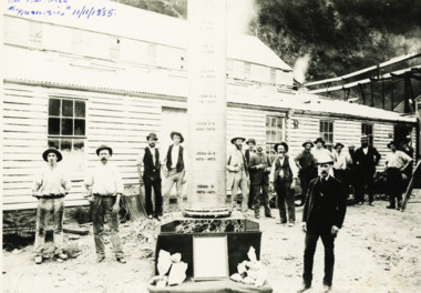
 Bendigo Historical Society Inc.
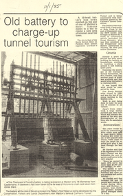
Document - LONG GULLY HISTORY GROUP COLLECTION:OLD BATTERY TO CHARGE-UP TUNNEL TOURISM
Photocopy of a newspaper article titled Old battery to charge-up tunnel tourism. There is a photo of a Thompson's Foundry battery which is being re-erected at the site of the North British mine on Parkin's Reef, near Carman's tunnel. The battery was recovered from a deep gully at Bola Creek. Other works include restoration of quartz roasting kilns and cyanide vats. Written at the top of the article is a date 11/1/85.bendigo, history, long gully history group, the long gully history group - old battery to charge-up tunnel tourism, thompson's foundry, parkin's reef reserve, conservation forests and lands department, carman's tunnel, north british mine, carman's tunnel committee, dr doug kemsley, the prospectors' and miners' association of victoria, mr ken garden -
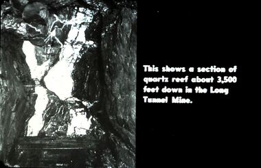 Bendigo Historical Society Inc.
Slide - DIGGERS & MINING. DIGGERS AND MINERS, c1930s-1940s
Diggers & Mining. Diggers and Miners. This shows a section of quartz reef about 3.500 feet down in the Long Tunnel Mine. Markings: 34 994.5 WAL. Used as a teaching aid.hanimounteducation, tertiary, goldfields -
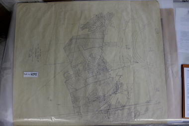 Coal Creek Community Park & Museum
Mine Map, 1942
6291.1 - Plan of "Austral Coal Mining Co" Lease in Korumburra detailing the mine tunnel plan, coal seam areas and some surface features such as railway sidings & Leura Creek. -
 Coal Creek Community Park & Museum
Mine Map
6306.1 - Map of Outtrim mining area, with modification where damage/erasure has occurred. Shows tunnels, faults, tramways, boreholes, surface roads and (apparently) paddock boundaries and a creek. -
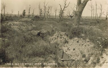 Bendigo Historical Society Inc.
Postcard - ACC LOCK COLLECTION: YPRES OLD TRENCHES NEAR ZILLEBEKE, POSTCARD, 1914-1918
Postcard, WW1, B&W image of Ypres old trenches near Zillebeke. Part of a corrugated iron fence at bottom of trench, leading to entrance of a tunnel. Defoliated trees in background.postcard, postcard, ww1, ypres, zillebeke, france, trenches -
 Bendigo Historical Society Inc.
Photograph - BASIL MILLER COLLECTION: TRAMS
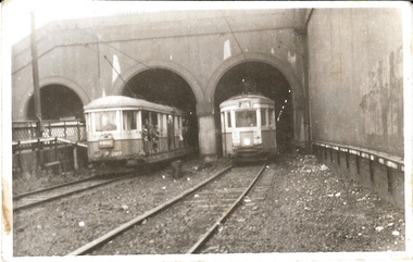
Black and white photograph of 2 trams, one entering and one leaving a tunnel. Inscription on reverse: 'O' class entering, and 'R' class emerging from Wynyard tunnel in tramway days of Sydney, (written in red ink). In blue ink, 28/2/1958. Last tramway day of Nth Sydney depot and lines serving Wynyard, the Spit, Balmoral Beach, Atho Wharf, Chatswood and Lane Cove. N.S.W. Tramways Hist. Scty.person, individual, basil miller -
 Bendigo Military Museum
Card - XMAS CARD, 1917
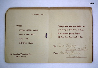
The card made by the 3rd Australian Tunnelling Coy AIF France.Christmas card with gold stamped rising sun badge. On Active Service with printed insetHandwritten on insert"Rose Lehmer/New South Wales/Brother Harry/Francedocuments-cards, christmas, aif -
 Coal Creek Community Park & Museum
Mine Map
8518.1 - Unlabelled map of mining tunnels, coal seams, boreholes, creeks, roads and (presumably) paddock boundaries. Based on features in common with other maps, very likely map of Korumburra area. -
 Tarnagulla History Archive
Photograph: Havelock Reef Ceremony, 28th April, 1995
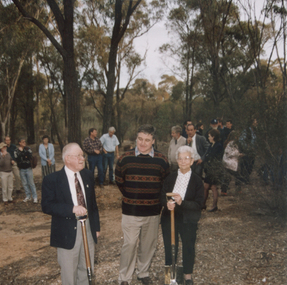
Donald Clark Collection. A colour photograph depicting Don Clark, Dick Sandner and Lorna Goltz at a ceremony to open drive to tunnel under the hill, Havelock Reef, South Poverty Reef, Tarnagulla. Original photograph. -
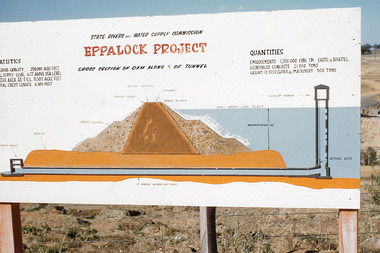 Bendigo Historical Society Inc.
Slide - Mouat Crawford Collection: Farming Life in the Wimmera, c1962
State Rivers and Water Supply Commission. Eppalock Project. Cross section of dam along tunnel. Markings: Plan of Eppalock Res. Near Bendigo SEP 62M. Used as a teaching aid.kodakwimmera, lake eppalock construction, irrigation, mouat crawford collection -
 Lakes Entrance Historical Society
Photograph - Goldmining Walhalla, J Phillips, December 1885
Detailed information on back of photograph regarding gold amountsBlack and white photograph showing the exhibits to be sent to the colonial and Indian Exhibition London by the Long Tunnel Company Many men in the photograph in front of weatherboard building Mechanics Institute Walhalla VictoriaSee Walhalla Memorialmines and mining, exhibition -
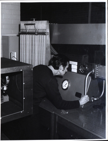 Federation University Historical Collection
Photograph - Black and White photograph, N. Harvey and Son, Ballarat School of Mines Laboratory Activities, 11/02/1972
Photograph of laboratories at the Ballarat School of Mines. 1. A male person at the viewing window of a wind tunnel. The man is probably Zig Plavina 2. Three males at a glass-sides tilting flume apparatus.ballarat school of mines, laboratory, tilting flume, wind tunnel, zig plavina -
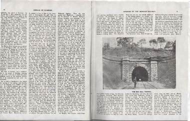 Bendigo Historical Society Inc.
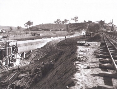
Document - RAILWAYS COLLECTION: THE BIG HILL TUNNEL
Railways Collection- Extract from page 78 &79 of Annals of Bendigo - Opening of the Bendigo railway - Black and white photo of The Big Hill Tunnel. The article describes the official Line opening ceremony.photograph, train -
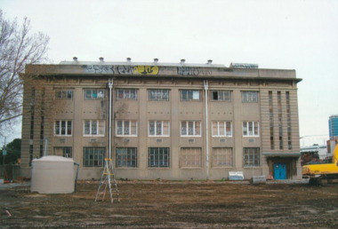 Port Melbourne Historical & Preservation Society
Photograph - Tunnel under Ingles Street, J Kitchen & Sons site, Port Melbourne, Lionel Layfield, 2014 - 2016
12 colour photographs relating to the tunnel at J Kitchen & sons factory site from rear of building 9 (Warehouse/factory) under Ingles St to the dispatch building on the other side of the road.industry - manufacturing, built environment - industrial, business and traders - soaps/candles, demolitions, j kitchen & sons pty ltd, symex holdings ltd -
 Bendigo Historical Society Inc.
Document - IAN DYETT COLLECTION: AUCTION CATALOGUE - NEW LONG TUNNEL GOLD MINE - WALHALLA
Catalogue for an auction sale held at the New Long Tunnel Gold Mine, Walhalla, Vic. On 12 February, 1941. Items include: mining machinery, tools, buildings, corrugated iron and leather belting.business, auctioneers, j h curnow & son pty ltd, ian dyett collection - auction catalogue - new long tunnel gold mine - walhalla, j h curnow & son, j l jamieson, the cambridge press -
 Bendigo Historical Society Inc.
Slide - DIGGERS & MINING. DIGGERS AND MINERS, c1864
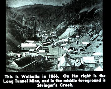
Diggers & Mining. Diggers and miners. Walhalla - Gold Town. This is Walhalla in 1864. On the right is the Long Tunnel Mine, and in the middle foreground is Stringer's Creek. Markings: 13 995 WAL. Used as a teaching aid.hanimounteducation, tertiary, goldfields