Showing 190 items matching "victoria floods"
-
 Bendigo Historical Society Inc.
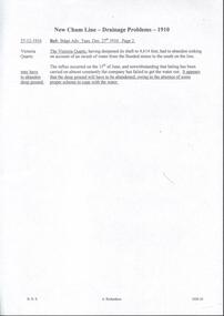
Document - DRAINAGE PROBLEMS - NEW CHUM LINE DRAINAGE PROBLEMS 1910
Handwritten extract from the Bendigo Advertiser 27/12/1910 Page 2. ''The Victoria Quartz, having deepened its shaft to 4,614 feet, had to abandon sinking on account of an inrush of water from the flooded mines to the south on the line. The influx occurred on the 15th of June, and notwithstanding that baling has been carried on almost constantly the company has failed to get the water out. It appears that the deep ground will have to be abandoned, owing to the absence of some proper scheme to cope with the water.'' Albert Richardson Mining History Collection.document, gold, drainage problems, drainage problems, new chum line drainage problems 1910, bendigo advertiser 27/12/1910 page 2, victoria quartz, albert richardson -
 Charlton Golden Grains Museum Inc
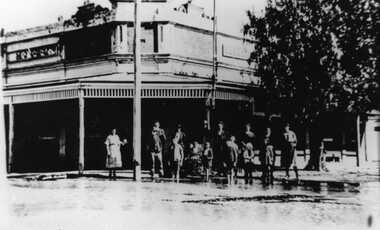
Photograph, 1923 Flood - Telegraph Hotel, Armstrong Street Charlton, c. 1923
... , Victoria Flood Telegragh Hotel Charlton Livingstone 1923 flood ...1923 Flood, Telegraph Hotel, Armstrong Street, Charlton, Victoria1923 flood - Telegraph Hotel, Armstrong Street Charlton. Obituary: Charlton 100 years ago 18-02-1922 - 24/02/1922. Mr Francis Gilbert Livingstone passed away at Castlemaine on 14th ins. He was a very well known & highly respected old resident of Charlton & Narrewillock. Until October last he held the license of the Telegraph Hotel and was a familiar figure in his wheel chair under the shade trees at land at Narrewillock, where he farmed until failing health compelled him to give up the strenuous work of those early pioneering days, and in 1892 he took the license of the Telegraph Hotel which he retained until recently. He was 61 years of age.flood, telegragh hotel, charlton, livingstone -
 Bendigo Historical Society Inc.
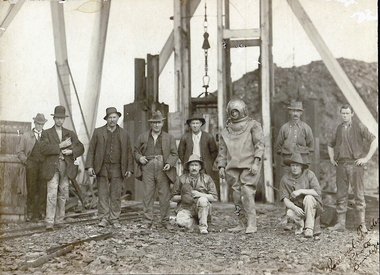
Photograph - TAMBOUR MAJOR MINE AT SPECIMEN HILL, 1920
Black and white photograph mounted on brown board. Ten males in front of mine shaft. One male in divers suit. Male second from L holding small dog. Cage and poppet legs in background. Mullock heap at back. Inscriptions: Hand written on BR corner of photo 'Percival Pinder, Photo, Bendigo' Hand written on board under photo 'Tambour Major GM Coy 846 ft'. On separate card glued to bottom of mount board, printed 'Diver inspecting flooded Tambour Major Mine at Specimen Hill in 1920'. Hand written in ball point pen on back 'Tambour Major' Mine Group photo taken at Tambour Major about 1920. Dad on extreme right, Joe Sheard, Mine Manager in diving suit. A Richardson, 29 Harrison Street' Hand printed in black ink on back 'Diver inspecting flooded Tambour Major Mine in 1920'. On back - circular purple stamp 'Royal Historical Society of Victoria, Bendigo Branch'.Percival Pinder, Bendigomining, surface equipment, tambour major mine, bendigo, mines and mining, miners, mine, specimen hill, flooded mine, diver -
 Melbourne Tram Museum
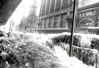
Photograph - Black & White Photograph/s, The Age, 17/02/1972 12:00:00 AM
Black and white photograph of a flood in Elizabeth St, with the GPO, Royal Arcade and London Stores in the background. Taken at the intersection with Flinders Lane. Shows a car with water washing over it and a safety zone in the background. Photograph by The Age, has a copy right stamp on the rear. Follows a massive downpour around the Queen Victoria Market. The cataloguer was working nearby in Collins St at the time, but no camera! See TMSV Running Journal April 1972 for details of the event.On the rear in pencil "Thursday 17/2/72 4 to 5pm, 3" Rain"trams, tramways, flooding, elizabeth st, gpo -
 Melbourne Tram Museum
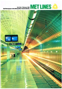
Magazine, Metropolitan Transit Authority (MTA), "Met Lines", 1986
Magazine, published by the Metropolitan Transit Authority of Victoria "Met Lines" (Metlines) - A4, printed on white gloss paper, with the MTA logo or symbol. Issued under the name of Kevin Shea as Chairman. References to Minister Tom Roper. Continues from Reg Item 1059 "Met Lines" - printed in an A4 version. Major tram and bus items listed. Tramway and bus names only listed, not railway. .1 - Vol 2 No. 1 - Feb. 1986 - front cover - Flagstaff station, St Kilda/Port Melbourne light rail system announced, police at Hawthorn learning about trams, Chinese delegation looking at Melbourne's trams, Elwood depot article with photos by Lloyd Rogers at time of Elwood depot coming part of The Met, promotional posters for tramcars, Tram cards, tram power supply upgraded (photo of Z129) - Brown Boveri equipment to Kew and Ascot Vale, memoirs of a tram conductress Nancy Scutt, item with photo of Conductor Jeff Harvey, employment notes, Preston Workshops Christmas party and presentation to Essendon depot tramway soccer champs by Norm Maddock. .2 - Vol 2, No. 2 - March 1986 - Jolimont workshops, modal interchange at Bundoora, Transport Information Centre, memoirs of a tram conductress continued, tram cricket matches, tramway bowls - photos and players listed, Harris trains to be phased out. .3 - Vol 2, No. 3 - April 1986 - front cover of a Met Tram overhead maintenance, linesmen training, new super scheme (old gratuity scheme), visit from ATMOEA NSW visit, Elwood bus depot 12 months with The Met, flying flags on trams, tramway bowls, cricket. .4 - Vol 2, No. 4, May 1986 - 20 pages - Met Information Centre - "Dreams of trams become a reality - driver Peter Gamble", tram tour for American visitors to the zoo, Harris trains, article and photos on Camberwell depot, pantographs on trams, face lift for trams (758) and new buses (182). .5 - Vol 2, No. 5, June/July 1986 - 40 pages - Clock shop, materials testing, lost property, chemical analysis - Preston Workshops, Bus Driving School, Munitions bus 301 at Hawthorn, AVM on trams (223), tram track repairs, relaying Preston workshops entrance for LRV's, new type of safety zones (967 and 871), Preston Workshops redevelopment for LRV's, tram shelters, transporting arts - new series, Michael Leunig, mentions Clifton Pugh tram 504, federal funding for trams, fitting air conditioners to trams. .6 - Vol 2, No. 6, August 1986 - 20 pages - front cover - rotary converter at Carlton, Doncaster bus depot celebrates 25 years, the day the rains came - Ray Marsh - 1972 floods, substations power tram network, Carlton, tram art of a different kind, launch of Leunig's tram. Doncaster party. .7 - Vol 2, No. 7, October 1986, 20 pages, artic buses start rolling (articulated), vandals, Robert Jacks tram launched, Peace tram 829,. .8 - Vol 2, No. 8, November 1986, 20 pages, MTA Annual report, Debbie Bateman Conductor thanked by passengers, Papal tour planning, MTA Ball, Frankston Neighbourhood launched, Essendon depot Soccer report. .9 - Vol. 2, No. 9, December 1986, 20 pages, Christmas issue, (has a $1.50 sticker on it), Met Lines year in review, Federal funding for more A class trams, Bundoora - La Trobe Uni bus interchanged opened, Domain Interchange opened, For next year 1987 - see Reg Item 1141 - Announced in December issue, Met Lines quarterly next year.trams, tramways, mta, the met, elwood depot, light rail, posters, power supply, kew, ascot vale, conductresses, sports, essendon depot, bundoora, jolimont workshops, tower truck, overhead, superannuation, flags, camberwell depot, drivers, trolley poles, pantographs, clocks, buses, avm, automatic vehicle monitoring, shelters, flooding, substation, carlton, transporting art, federal funding, a class, domain interchange, tram 2001, tram 129, tram 234, tram 50, tram 504, tram 871, tram 967, tram 223, tram 758 -
 Melbourne Tram Museum
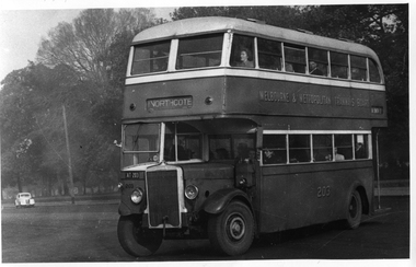
Photograph - Set of 11 Black and White photograph, Ken Flood, 18/04/1974 12:00:00 AM
Set of 11 black and white photographs sent to Keith Kings received from Ken Flood 4/6/1975. .1 - Bus No 203 1940 Leyland TD5c - Turning from Nicholson Street into Gertrude Street. - bound for Northcote. .2 - Bus No 201 1940 Leyland TD5c - In Nicholson Street at Albert Street - Photo. bound for Northcote .3.- Bus No 492 1943 Ford Austerity - at Queens Pde Clifton Hill - Note the Pram and Passenger bus sign by the front doorway. Photo not dated. .4 - Bus No 365 1948 OPS1 - Nicholson Street at Victoria Pde. bound for East Brunswick. Photo not dated. .5 - Bus No 325 1950 OPS4 - Nicholson Street at Victoria Pde. bound for East Brunswick. Photo not dated. Bus did not enter service until 1950. .6 - Bus No 500 1943 Ford Austerity - Marine Pde. Point Ormond. Note the Pram bus sign by the front door. .7 - Bus No 19 1938 Leyland Cub (diesel) with Preston Workshops body. - Lonsdale Street at William Street. W2 No 305 passes behind the bus. Late 1940's photo. .8 - Bus No 143 1940 Leyland TS8c drop enter - in Russell Street at LaTrobe Street bound for North Kew. (Belford Road via Collingwood). Photo not dated. .9 - Bus No 9 1938 Leyland Cub (diesel) with Preston Workshops body. - in Russell Street at LaTrobe Street bound for North Carlton .10 - Bus No 4 1938 Leyland Cub (Diesel) with Preston Workshops body - in Lonsdale Street at William Street. note destination not reset for the return trip. .11 - Bus No 150 1940 Leyland TS11c Drop enter - Nicholson Street at Victoria Pde. Photo not dated. Most of the photos dated 9/6/1949 unless noted otherwise. Notes on photos provided by Rod Atkins - see htd5860doc.pdfOn rear of the photos in ink; .1 - MMTB 203 9/6/49 - K Flood .2 - MMTB 201 - 9/6/49 - K Flood .3 - MMTB Ford #492 - K Flood .4 - MMTB #365 - K Flood .5 - MMTB #325 - K Flood .6 - MMTB #500 Pt Ormond 6/6/49 - K Flood .7 - MMTB #19 9/6/49 - K Flood .8 - MMTB #143 - K Flood .9 - MMTB #4 9/6/49, K Flood .10 - MMTB #4 9/6/49, K Flood .11 - MMTB #150 - K Floodtrams, tramways, buses, double deck buses, prams, mmtb buses, austerity buses, w2 class, tram 305, bus 203, bus 201, bus 492, bus 365, bus 500, bus 19, bus 143, bus 9, bus 4, bus 150, leyland, ford motor company, td5c class, ops1 class, ops4 class, ts8c class, cub class, ts11c class -
 Lakes Entrance Historical Society
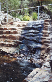
Photograph - Costick's Weir, 1999
Built 1942 - 43 to ensure as adequate water supply for fire fighting purposes, after the devastation of the 1939 forest fires. Used by locals as a swimming pool until flooding in the 1980's filled the weir with silt.Colour photograph of Costicks Weir, Old Colquhoun Road, Colquhoun Forest. Shows manmade dam in bush setting. Constructed by building a weir wall across a small natural gorge. Nowa Nowa Victoriavegetation, weir's, local history -
 Charlton Golden Grains Museum Inc
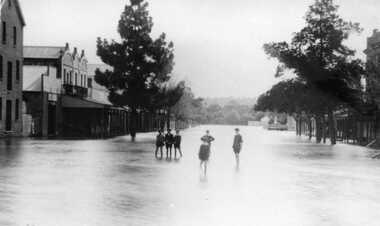
Photograph, Aug 1909
... 1909 flood, High Street, Charlton Victoria. Children...1909 flood, High Street, Charlton Victoria. Children ...1909 flood, High Street, Charlton Victoria. Children standing in floodwater in High Street looking west from corner of Armstrong Street. Malcolm's Flour Mill and Proctors Double story building.B/W photograph of 1909 flood. Children standing in floodwater in High Street looking West from Corner of Armstrong Street Charlton.flood, charlton, armstrong street, arm -
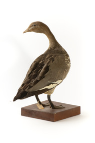 The Beechworth Burke Museum
Animal specimen - Australasian Wood Duck (female), Trustees of the Australian Museum, 1860-1880
The Australasian Wood Duck is commonly described as 'goose-like' in appearance. They reside throughout Australia and Tasmania in regions including grasslands, open woodlands, wetlands, flooded pastures and along the coast and bays. Unlike some breeds of ducks, this species can walk on land with ease and can often be seen perched on logs and in trees. The Wood Duck eat grass, clover and other herbs. On occasion they eat insects. This specimen is part of a collection of almost 200 animal specimens that were originally acquired as skins from various institutions across Australia, including the Australian Museum in Sydney and the National Museum of Victoria (known as Museums Victoria since 1983), as well as individuals such as amateur anthropologist Reynell Eveleigh Johns between 1860-1880. These skins were then mounted by members of the Burke Museum Committee and put-on display in the formal space of the Museum’s original exhibition hall where they continue to be on display. This display of taxidermy mounts initially served to instruct visitors to the Burke Museum of the natural world around them, today it serves as an insight into the collecting habits of the 19th century.This specimen is part of a significant and rare taxidermy mount collection in the Burke Museum. This collection is scientifically and culturally important for reminding us of how science continues to shape our understanding of the modern world. They demonstrate a capacity to hold evidence of how Australia’s fauna history existed in the past and are potentially important for future environmental research. This collection continues to be on display in the Museum and has become a key part to interpreting the collecting habits of the 19th century.The female Wood Duck has a pale brown head with dark glass eyes. The head is looking backwards over left shoulder. The bill is a dull grey colour and the legs are a similar grey.The breast is speckled cream-grey with a white lower belly and under-tail. There is a paper tag tied to the upper part of the Wood Duck's right leg, a white label attached to the front right of the wooden platform and a grey label on the left beside the white label.....[missing] Goose / ....[missing] page 38. / 133 /taxidermy mount, taxidermy, animalia, burke museum, beechworth, australian museum, skin, reynell eveleigh johns, bird, australian birds, australaisian shovelor, shovelor, wood duck, australian wood duck, female duck, maned duck, female -
 Bendigo Historical Society Inc.
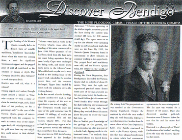
Document - LONG GULLY HISTORY GROUP COLLECTION: THE MINE FLOODING CRISIS - FINALE OF THE VICTORIA QUARTZ
BHS CollectionPhotocopy of a newspaper article titled Discover Bendigo by James Lerk titled The Mine Flooding Crisis - Finale of the Victoria Quartz. Soon after the flooding of the mine commenced in June 1910, tributers worked the upper levels. By 1913 the Company found it was uneconomic to allow tributers to continue working in the upper levels. Four Bendigo men, Ernest Smith, David Holden, Jack Harrison and David Patullo worked the mine during the Depression. They did well. A photo of David Patullo is in the article.bendigo, history, long gully history group, the long gully history group - the mine flooding crisis - finale of the victoria quartz, james lerk, victria quartz, brough smyth, bendigo advertiser 1912, great depression, ernest smith, david holden, jack harrison, david patullo, government battery eaglehawk -
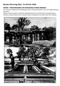 Wodonga & District Historical Society Inc
Photograph - Wodonga Creek Stock Bridge Collection
The Wodonga Creek Stock Bridge was constructed by the Country Roads Board in 1939. The date was recorded on a small plaque attached to one of the trestles. The bridge is an important reminder of one of the industries Wodonga was built on — cattle. It was constructed to develop a new stock route between Albury and Wodonga which would direct cattle away from the main bitumen roads and traffic bridges to the Wodonga Saleyards, where thousands of sheep and cattle were sold each month. It is a moderately tall timber trestle road bridge consisting of nine spans, with a deck length of 76 metres and deck width of 4.5 metres, and a maximum span length of 8.5 metres. The substantial timber deck featured decking laid horizontally and longitudinal running planks laid on top of it. The bridge also has timber side safety rails to discourage livestock from straying over the side. The bridge also became the centre of summer social activity for the young people of Wodonga as the area became a gazetted swimming area before the Wodonga Swimming Pool was constructed in 1959. In 1980 the Wodonga Saleyards were relocated to Bandiana to the east of the city. This meant that Wodonga Creek Stock Bridge was no longer needed for its original purpose. Although listed as a significant site by the Victorian Heritage and National Heritage Trust on 3/08/1998, the bridge fell into disrepair and also suffered damage from several floods. A suspension Bridge was constructed beside the Stock Route Bridge in 2013 and the old bridge was closed to traffic. Major damage caused by several floods, including a major flood in 2022 has resulted in the bridge being unsafe and its future is uncertain. The model of the Wodonga Creek Stock Bridge in our Collection made by Mr John Wild, depicts its current condition.The Wodonga Creek Stock Bridge is significant for technical, historic and social reasons and has been registered at the State Heritage level. It is of technical significance as a nine span bridge with tall timber trestles. Large bridges of this type are now very rare in Victoria. It is of historic significance as a surviving structurally authentic bridge designed specifically for livestock and drover use, on a historic stock route. The Stock Bridge is of social significance for its location at a popular riverside leisure spot since its construction in 1939.A collection of photographic images depicting the Wodonga Creek Stock Bridge. It contains both black and white and coloured images taken at different times in the Stock Bridge's history. A model of the Bridge made for Our Society is also included.wodonga creek stock bridge, wodonga heritage -
 City of Moorabbin Historical Society (Operating the Box Cottage Museum)
Newsletter - CMHS Moorabbin Mirror Issue 13 February 2018, CMHS Moorabbin Mirror Newsletter Issue 13 February 2018, 2018
This is Issue 13 of the Moorabbin Mirror produced by CMHS members Fran & Holger Bader , Geoffrey Paterson, February 2018 The Moorabbin Mirror reflects the history and heritage of the former City of Moorabbin — derived from Mooroobin, ‘a resting place’ in the Bunurrung spoken language. In 1994, the City of Moorabbin was integrated into the Cities of Bayside, Glen Eira, Kingston and Monash. Topics: Vale Mr Laurie Lewis; Street Names Files; KCC Tribute for Dr G Whitehead 20years ; Local heritage 'What House is that?'; Sands & McDougal 1860-1974 digitized by State Library Vic.;Alan Clarke donated in 2016 handwritten S&M copies of residents ; 1818 1st Australia Day Gvnr. Lachlan Macquarie;1858 Foundation Stone St Patrick's Cathedral laid by Bishop J.A. Goold; 1882 Assassination attempt on A/Bishop Goold in Brighton; 1948 UN Declaration of Human Rights; Census Victoria 2016 results; Plateways by Phil Rickard Light Rail HS;Flooding at BCM Dec./Jan. ; August Rietman Exhibition Report & Photos; This is Issue 13 of the Moorabbin Mirror, Newsletter of CMHS February 2018A4 x 3 paper folded to A5 x 6pp printed both sides with colour photographs. Moorabbin / Mirror / Newsletter City of Moorabbin Historical Society Inc. A0020543 (CMHS) / operating Box Cottage Museum (BCM) / ISSUE 13 FEBRUARY 2018moorabbin mirror, bader fran, bader holger, patterson geoffrey, lewis laurie;street name files; whitehead dr g.; sands and mcdougal; clark a; archbishop gool j.a.; st. patrick's cathedral melbourne; governor macquarie l.; plateways; rickard phil.; ohm 2017; reitman august, rietman stefanie; rietman william; lone digger memorials wwi; -
 Eltham District Historical Society Inc
Document - Folder, Orford family
The Orford family, a pioneer family remained continuously living and working in Eltham for 170 years from 1854 to 2024. James and Sarah Orford arrived in Sydney in 1839 aboard the ship “Orestes”; they had several children there before settling in Eltham in 1854. Three children, James Mathias, Sarah Amelia and Thomas Henry initially remained in the Eltham area. James eventually moved to Brunswick. Sarah married Arthur Butler Young and finally lived in Bunyip. Thomas who was six years old when the family arrived in 1854 remained in Eltham, married Helen Logan who died, leaving a large family. They lived in a slab hut by the Yarra at Laughing Waters and Thomas managed the Panton Park Estate, a selection owned by Magistrate Thomas Panton. Thomas’s son, Ernest Orford was born 1892 at Pitt Street, Eltham and also lived his entire life in Eltham working as a labourer, orchardist and later as a gardener and grounds keeper for Sir William Irvine, a former Chief Justice and Premier of Victoria. Ernest married Kate Thomas; their two sons Ron and Doug stayed in the area. Another of Thomas' sons, Arthur, also lived in Eltham. Four Orford generations attended Eltham schools. Doug Orford was born on the kitchen table (reference, son Ted Orford) of the family home at the corner of Reynolds Road and Mount Pleasant Road. Doug married Gwen and they established a family however Gwen died at a young age from cancer. Doug eventually remarried another Gwen and they lived for several decades in Napoleon Street, Eltham. Doug was actively involved in EDHS over many years, including serving as a committee member and vice president. Contributions by Doug and Gwen (Treasurer/Membership Secretary), his wife, assisted EDHS to continue to develop as a not-for-profit group intent on promoting and preserving our local history. Both Doug and Gwen were made Life Members of EDHS. They also acted as EDHS delegates to the Eastern Region of Historical Societies. His significant work with assisting to establish our valued Local History Centre helped develop our home base and supported the continued growth of our society. Doug’s local knowledge, suggestions and family connections were highly valued, Until recent times, he continued to regularly attend our Collections Team workshops providing his insights and historical information about photographs and society records. Doug died peacefully July 8, 2024, and represents the last link in the Orford Eltham chain which spanned 170 years. His funeral was held Thursday, July 18, 2024, at Le Pine Funerals, 848 Main Road, Eltham. Contents: Typed notes, no date: Memories of Ernest Orford [taped 1979] about his school days. Handwritten notes, no date: History of Ernie Orford Typed notes, no date: History of Thomas Henry Orford and family. Photocopy: Shire of Eltham General Rate Receipts. Received from D Orford 7 June 1923 and Received from E F Orford, 4 August 1924. Letter, no date: Nillumbik Shire to Russell Yeoman, Gwen Orford to receive Volunteer Recognition Award. Newsletter article: "The Orford Family, Eltham", Shire of Eltham Historical Society, No.80 September 1991. History of Orford family. Handwritten notes: 21 March 2011, genealogy of George Orford. On reverse Melways map makred with Orford and other land ownerships. Newspaper advertisement, 21 March 2011: "264 Reynolds Road, South Eltham", property for sale [land in ownership of Orford family]. Letter: St Margaret's Anglican Church Eltham to Doug Orford, 17 November 2011, Extracts from church records relative to Orford family. Newspaper article: "Timely facelift at war memorials', Diamond Valley Leader, 30 April 2024, Nillumbik war memorial will have some work and a bronze plaque will be installed at the Eltham Avenue of Honour, Wingrove Park; photograph of Doug Orford Newsletter item: "Welcome home medal", Eltham District Historical Society newsletter no.216 May 2014, World War I two 'Welcome Home Medals' in ownership of local men, being Harry Gilham and Doug Orford. Order of Service, Le Pine Funerals (Eltham), In Loving Memory of Douglas Frederick Orford 22nd August 1929 - 8th July 2024 Doug Orford Reminiscences (2002) in conjunction with Jock Read and Peter Bassett Smith; 4 pages - 3 typed, 1 handwritten possibly transcribed from an audio tape recording (location unknown). New word file and associated pdf created [\Dropbox\EDHS DATA\DOCUMENTS\COLLECTION CATALOGUE DOCUMENTS AND PDFs\2-2 Family Folders\EDHS_06110-2 Doug Orford reminiscences 2002.docx - 1 April 2025]Newspaper clippings, A4 photocopies, etcdoug orford, harry gilham, welcome home medal, eltham avenue of honour, nillumbik war memorial, wingrove park, henry dendy, alfred armstrong, james orford, 264 reynolds road south eltham, george orford, george joseph orford, maryanne george joseph, thomas henry orford, ernest orford, e f orford, eltham cemetery, helen orford, joseph panton, panton park, gordon lyon, banyule estate heidelberg, james matthias orford, wurundjeri, constable peter lawlor, george hill, franklin street eltham, ronald orford, eltham primary school, john brown, robert gamble school inspector, sarah orford, mary ann orford, james mathias orford, sarah amelia orford, james peet, arthur butler young, watsons creek victoria, kangaroo ground victoria, helen logan, william orford, jane orford, arthur orford, frederick orford, florrie orford, victor orford, chem orford, sunnymede eltham, panton hill estate, sir william irvine, gordon lyons, kate thomas, north eltham gospel church, harold clapp, eltham cricket club, research primary school, dalton street school eltham, keith banks, betty banks, benjamine boyd, laughing waters road eltham, freddie gilsinen, douglas frederick orford, eltham district historical society, funeral service, le pine funeral home, life member, order of service, 1934 flood, 1939 bushfires, alcock & pierce, ansell, associated schools sports, blacksmith shop, boakes, bridge street, bryce family, bullock track, butcher, catholic church, cliff lester, cliffy green, daisy smith, dave lyon, diamond creek, diana bassett smith, dick tooth, dr. frank may, eltham higher elementary school, ernie andrew, fire station, flower stall, fodder business, fruit shop, furniture store, gahan family, garni burges, greensborough, harold norman, harry hawker, hat factory, hawker & owen, hay and com store, henry hawker, henry street, j .harry butherway, jack burgoyne, jack ryan, jock read, john lyon, junk yard, kevin gahan, kilpatricks, len parsons, lyon family, machine factory, mc leans, memorial, metery road, miss reynolds, monteith 's bus, mr. gadd, mrs. bird, mrs. morrison, napoleon street, peter bassett smith, peter's gahan, plenty river, plumridge, produce store, public hall, rechabite hall, reynolds road, roger bird, rutter family, ryan family, shoe factory., staffs produce store, studley cairn gahan, sweeneys lane, swimming pool, taylor street, tennis court, warren family, wooden bridge, yarra brae road -
 Flagstaff Hill Maritime Museum and Village
Weapon - Historic Rifles, Royal Small Arms Factory, 1877-1900
... was important to travel in the southwest Victoria district, providing ...Martini-Henry Artillery Carbin rifles were made by the Royal Small Arms Factory at Enfield, Britain, from 1877 until 1900. Many were distributed to the British Colonies, including this pair, which was allocated to the Woodford Police, Victoria Police District of Warrnambool, Southwest Victoria. The Carbine model rifles were shorter than the standard rifles and more suited to mounted police and troopers. It is likely that in the early 20th century, Victoria Police replaced the two carbines with more modern firearms, and the outdated guns were stored in the stables. The rifles were left there and likely forgotten about due to changes in police staff. In 1915, police authorities announced that they would be replacing patrol horses with bicycles and would also close some smaller police stations. This affected Woodford Police Station, which closed in 1917. The forgotten firearms remained in the stables and were noticed by schoolboy Robert Jellie in 1940 and seen again in 1946. In 1995, the property was sold by the Education Department to a private owner. The Woodford Community donated the pair of Martini-Henry Carbines to the Victoria Police Museum in the late 1990s for mounting and display, which was funded by the Victoria Police Historical Society Inc. The decorative wood and glass display case and frame were designed to preserve the significant history of the guns. On November 1st 1999, the display was presented to Warrnambool Police and the local community due to the historical significance of the Woodford Police Station. In 2025, these items were formally deaccessioned by the Victoria Police Museum, and ownership was transferred to the Warrnambool Police Station. On March 10th, 2025, the display was transferred to Flagstaff Hill Maritime Museum and Village, where the historical story of the Martini-Henry Carbines could continue to be preserved and accessed by local families, the community, visitors to the area, and online visitors. WOODFORD POLICE: - The small settlement at Woodford was established in the 1840s around the Merri River where there was a ford across the water and a bridge from 1848 to 1851. The area was settled very early in Victoria’s history, and the river crossing provided travellers with access to the early route between Port Fairy (named Belfast at that time), Warrnambool and Melbourne. Occasionally, a Warrnambool police trooper would ride through Woodford and the district. In December 1854, Woodford Police barracks and stables were built on the hill by the Merri River on Bridge Road east, where Jubilee Park now stands. A local mounted trooper kept law and order in the area. In 1856, a lock-up was installed, and the first Woodford Police Station was in action in 1857. By 1871, the police station had been moved from the hill to land across the Merri River bridge, on the southern side of Bridge Road west, near Mill Street. In 1890, the police residence there was replaced by a stone Edwardian-style building with the stables and lock-up behind it and the old police station at the rear. The police continued to have a presence in Woodford until it was closed by the Police Commissioner in July 1917 for economic reasons. The residence was used for government housing until 1923, when it was taken over by the Education Department for the school teacher’s home. In 1995, it became privately owned. THE MARTINI-HENRY ARTILLERY CARBINE: - The Martini-Henry rifles were made in Britain from 1871 at the Royal Small Arms factory at Enfield and were stamped with the symbol of the Royal Cipher (Crown over VR) over ENFIELD to identify their origin. They were named after two of several people who helped design this method: Swiss Friederich von Martini and Scotsman Alexander Henry. The design was breech-loaded, and the inner barrel was rifled. A thumb rest was incorporated into the top right of the bullet receiver’s chamber. The small teardrop lever on the right side of the rifle showed whether the rifle was ready to be shot. In 1877, the shorter, lighter-weight Carbine version of the firearm was produced for mounted troops and artillery. Its official name was “Carbine, B.L., Rifled, Martini-Henry.” The bullets were slightly lighter in weight than those used for the longer rifle. The sight position was adjusted for the shorter gun, and wings were added to the sight on the tip, making it easier to slide the rifle back into a saddle bag. Some of the later Carbines also had leather sight covers screwed to the stock to prevent them from catching on the saddle bags. The Carbines had accessories available, such as barrel extensions with bayonets and swivels for adding slings. The Martini-Henry Carbine designs were later modified to fire the British .303 ammunition. Eventually, by 1900, the Martini-Henry Carbines were replaced by the Lee Enfield gun design. The pair of Martini-Henry Carbine firearms represents policing in the early pre-1900 days of colonial settlement; Woodford was one of the first townships settled in Victoria, and it had a police presence from 1854 until 1917. The rifles and display provide a historic connection between the location of Woodford and relatives and associates. The carbine rifles show a stage in the evolution of weapon design, adapted to suit mounted troops, and adding features to streamline use and storage. The ammunition was also improved during this progression. The carbines are important for their connection to policing law and order in a remote area. They are significant for their association with the township of Woodford, which was important to travel in the southwest Victoria district, providing access across a river for a road between Port Fairy and Melbourne, and later Warrnambool, and supplying food, goods and accommodation for the travellers. A pair of mounted rifles is mounted behind glass in a timer case, accompanied by a framed display of two photographs and an account of the rifles’ history. The case and display each have a horizontal board with a gently curved edge and carved decorations added. The identical firearms are British-made Martini Henry Carbine breach-loaded rifled guns, supplied by Britain to its Colonial troops from around 1877. The rifles are lever-action, single-shot .500 calibre weapons. They have a teardrop lever on their right side. They were used by Victoria Police mounted troops at the Woodford Police Station, Victoria. The black and white photographs were taken in 1946. The left photograph has a circled area; the right photograph is an enlarged view of the circled area, showing the Woodford Police Station in detail. The printed text is on textured paper with the Victoria Police watermark. It gives a summary of the rifle’s history. There is an inscription on the left photograph. Left photograph, handwritten in white pen: “WOODFORD” Document’s print: “During the late 1840s the small town of Woodford grew around the crossing of the Merri River on the Melbourne/Port Fairy Rad. Woodford was proclaimed a township in 1854 and a police quarters was established there in 1857. The police station remained until 1917 when it was closed and police service from then on was provided from Warrnambool. The building was then used as a school residence and is now privately owned. In !940 Robert JELLIE, then a schoolboy, observed two rifles mounted on the wall of the disused stable at the rear of the old police building. Following the devastating flood of 1946 (see photograph above) the rifles were again seen in the room next to the stable but were not seen again until the building was sold by the Education Department many years later. It was a recognition of the historical value of the rifles which led to their donation to the Warrnambool Police Complex. The rifles have been authenticated by the Victoria Police Armoury as being Victoria Police issue some time before 1900. The rifles are an identical pair of the famous British-made Martini Henry, a .500 inch calibre military weapon widely used by British Colonial troops. Victoria Police and the wider community of Warrnambool are indebted to the members of the Woodford community for their fine gesture in donating the rifles for mounting so that their historical importance can be preserved and they can be displayed for generations to come. This display was funded by the Victoria Police Historical Society Incorporated, and presented on the first day of November, 1999.”flagstaff hill maritime museum and village, great ocean road, shipwreck coast, martini henry, victoria police, woodford police station, rifle, carbine, display case, british, martini henry carbine, breech-loaded, rifled, colonial, single-shot, .500 calibre, weapon, gun, 1877, troops, mounted troops, merri river, victoria police woodford, victoria police warrnambool, victoria police melbourne, police quarters, robert jellie, school residence, stable, 1946 flood, victoria police armoury, identical pair, british colonial troops, victoria police historical society incorporated, woodford, bicycles, found by a schoolboy, edwardian-style building, victoria police museum, warrnambool police station -
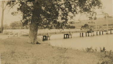 Lakes Entrance Historical Society
Photograph - Swan Reach Bridge, 1/12/2027 12:00:00 AM
The temporary bridge was in use until for four years, following the collapse of the permanent bascule bridge on 17 November 1925 due to attack by teredo worm. The temporary bridge was swept away during a flood in June 1930.Sepia toned photograph of a pontoon bridge over the Tambo River at Swan Reach Victoria, built as a temporary crossing after the collapse of the bascule bridge on 17 November 1925. Tambo River Christmas 1927 on reversereligion, buildings -
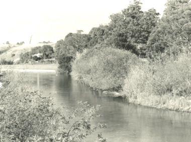 Lakes Entrance Historical Society
Photograph, G Legg Bairnsdale, Tambo River, Tambo Upper Victoria, 1970 1980 c
Black and white photograph of Tambo River, Tambo Upper Victoria. Also a black and white photograph of flood in the Tambo River location not identified rivers, topography, farming -
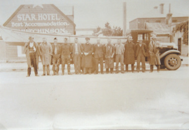 Lakes Entrance Historical Society
Photograph, H D Bulmer, Lakes Entrance fisherman rescue during 1934 floods near Sale, 1934 c
Lakes Entrance fishermen travelled to the Sale area to assist in the rescue of flood victims during 1930sSepia toned photograph of Lakes Entrance fishermen standing beside a boat on the tray of a small truck outside the Star Hotel Sale Victoriaships and shipping, floods, natural disasters -
 Lakes Entrance Historical Society
Postcard, Segerberg and Bulmer, Hospital Creek East Gippsland Victoria, 1913 c
Photograph Segerberg and Bulmer in partnership 1908 - 1913Black and white postcard showing heavily timbered country surrounding a timber bridge over the flooded Hospital Creek East Gippsland Victoriaocean, topography -
 Lakes Entrance Historical Society
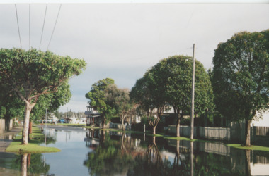
Photograph, Bulmer Street in flood Lakes Entrance Victoria, 2004 c
... Bulmer Street in flood Lakes Entrance Victoria....Floods Naturalm Disasters Township Colour photograph ...Colour photograph showing flood water in Bulmer Street looking south towards the Cunninghame Arm Lakes Entrance Victoria. Also second colour photograph taken at same time plus another of a house under construction following a mini tornado in 2005floods, naturalm disasters, township -
 Lakes Entrance Historical Society
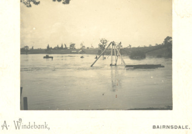
Photograph - floods in Mitchell River at Port of Bairnsdale Victoria, A Windeback, 1903 c
... of Bairnsdale Victoria floods in Mitchell River at Port of Bairnsdale ...Super structure of wharf crane just visible above floodwatersBlack and white photograph mounted on heavy card of floods in Mitchell River at Port of Bairnsdale Victoriabridges, boats and boating, rivers, floods -
 Lakes Entrance Historical Society
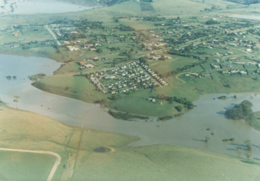
Photograph - Mitchell River in flood Bairnsdale Victoria, 1/04/1990 12:00:00 AM
... Mitchell River in flood Bairnsdale Victoria ...Mitchell River in flood Bairnsdale Victoria ... of Wy Yung near Bairnsdale Victoria Mitchell River in flood ...There was a deluge overnight in headwaters of Mitchell and Avon Rivers so the rivers rose overnight and flooded low lying areasColour aerial photograph of Mitchell River in flood showing Clifton Waters Village in centre and township of Wy Yung near Bairnsdale Victoriarivers, floods -
 Bendigo Historical Society Inc.
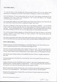
Document - VICTORIA HILL - VICTORIA HILL AND NEW CHUM HILL
Typed notes on Victoria Hill and New Chum Hill. Notes give location, value of gold and plans for a mining museum.document, gold, victoria hill, victoria hill and new chum hill, john neil macartney, the age, the australasian, bendigo goldfields registry 1871, victoria reef quartz mine, north old chum, victoria consols, new chum and victoria, pioneer, lansell 222 mine, lazarus, barnet lazarus, mt. alvernia hospital, fortuna villa, george lansell, a. h. q. survey regiment, central red white and blue, hudsons, burrowes & sterry, b c v channel 8, bendigo and district tourist association, section 14 of the lands act 1958, mr a r richardson, cr t r flood, tourist association -
 Lakes Entrance Historical Society
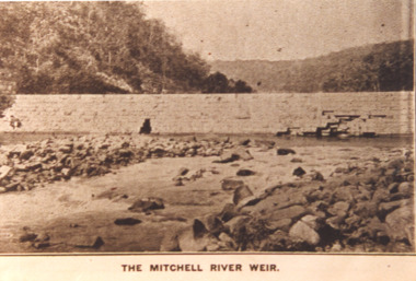
Photograph - Mitchell River Weir, Glenaladale Victoria, 1900 c
The Mitchell River Weir was commenced in 1900 work continued until almost completed, Foundation stone laid in March 1893 but the extensive flood damage in December 1893 ended the high hopes of the planners.Sepia toned photograph of weir on the Mitchell River at Glenaladale Victoriatopography, waterways, weir's -
 Bendigo Historical Society Inc.
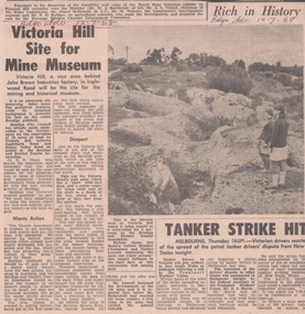
Newspaper - VICTORIA HILL - SITE FOR MINE MUSEUM
... and District Association Cr T R Flood Victoria Quartz Gold Mine ...Newspaper article and photo from the Bendigo Advertiser dated 12/7/68. Article mentions Victoria Hill, behind John Brown Industries Factory, will be the site for the mining and historical museum. Photo shows two visitors looking at the open cut area of Victoria Hill.newspaper, bendigo advertiser, victoria hill, site for mine museum, john brown industries, bendigo city council, bendigo and district association, cr t r flood, victoria quartz gold mine, lansell's 180 mine, theodore ballerstedt, mr george lansell, heather champness, shirley leersen -
 Lakes Entrance Historical Society
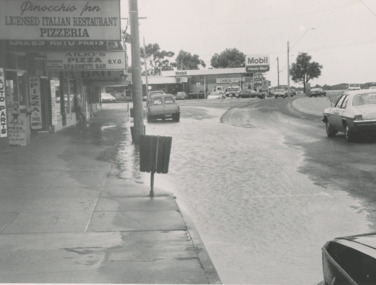
Photograph - Flooding of Esplanade Lakes Entrance Victoria 1993, Lakes Post Newspaper, 1/09/1993 12:00:00 AM
... Entrance Victoria Photograph Flooding of Esplanade Lakes Entrance ...Flooding due to inadequate drainage, it soon went down.Black and white photograph showing flooding on Esplanade west of Myers Street intersection, businesses in photograph Pinochio Pizzaria, Lakes Auto Parts, Arjus Pizza, Bait and Tackle and Mobil Service Station on opposite corner Lakes Entrance Victoriabusiness, roads and streets -
 Lakes Entrance Historical Society
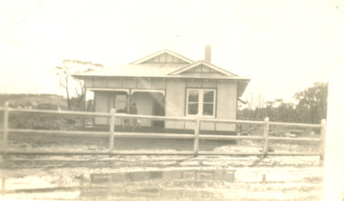
Photograph - Home of Fish Family, Roadknight Street Lakes Entrance Victoria, 1926 c
Also an enlarged copy of same photograph 05006.1 Built by J C Dahlsen for Vic Fish and family. Became shell museum 1960 to 70s for Mrs Newmans Camp Park named Gelia changed to Echo Beach, had various ownersBlack and white photograph of a small fibro clad house built for Vic and Myrtle Fish surrounded by receeding flood waters in Roadknight Street Lakes Entrance Victoriahouses, genealogy, floods -
 Lakes Entrance Historical Society
Photograph, Bairnsdale Advertiser, East Gippsland Floods 1988, 1/11/1988 12:00:00 AM
... Also two other black and white photographs of raging flood ...Also two other black and white photographs of raging flood waters during same flood event. 04933.1 10 x 17 cm and 04933.2 18 x 24.5 cmBlack and white photograph showing flood waters flowing through a camping park with two large tents and a caravan surrounded East Gippsland Victoriaoil and gas industry -
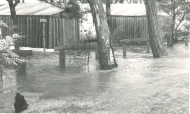
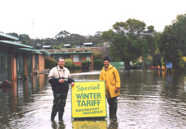 Lakes Entrance Historical Society
Photograph - floods 1998 Lakes Entrance Victoria, George Kyriakoo and Michael Pompaii at Sherwood Lodge Motel Lakes Entrance Victoria, 1/06/1998 12:00:00 AM
... floods 1998 Lakes Entrance Victoria... Photograph floods 1998 Lakes Entrance Victoria ...Colour photograph taken during floods showing George Kyriakoo and Michael Pompaii with water tariff sign at Sherwood Lodge Motel Lakes Entrance Victoriafloods, caravan parks -
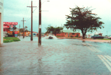 Lakes Entrance Historical Society
Photograph, Lakes Post Newspaper, floods 1998, Lakes Entrance Victoria, 1/06/1998 12:00:00 AM
... floods 1998, Lakes Entrance Victoria... taken during floods of part of Esplanade Lakes Entrance Victoria ...Colour photograph taken during floods of part of Esplanade Lakes Entrance Victoriafloods, gippsland lakes, natural disasters -
 Lakes Entrance Historical Society
Photograph, Jack Donelly, floods 1998 Lakes Entrance Victoria, 1998 c
... floods 1998 Lakes Entrance Victoria... the Western Pier at the entrance Lakes Entrance Victoria floods 1998 ...Photograph taken from Jemmys PointColour photograph showing discoloured flood water backed up by the incoming tide with fishing boat Crianda shown approaching the Western Pier at the entrance Lakes Entrance Victoriafloods, accommodation