Showing 14991 items
matching view to
-
 Lakes Entrance Historical Society
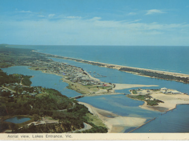
Postcard - Aerial view Lakes Entrance, Murray View Gympie Qld, 1970 c
Also a second postcard lookin west showing township, North Arm and Kalimna Heights 05213.1 10 x 15 cmBlack and white postcards showing aerial views of township, North Arm and Cunninghame Arm, Bullock Island and part of Kalimna Heights and Jemmys Point Lakes Entrance VictoriaAerial view of Lakes Entrance Victownship, waterways, islands -
 Camberwell Historical Society
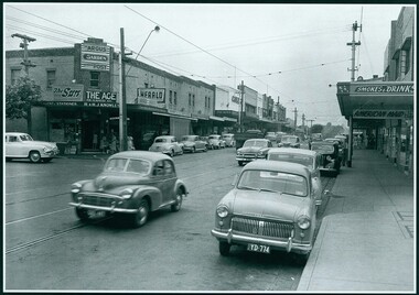
Photograph, Camberwell, Victoria, view of Toorak Road and stores, c. 1950
Print of photograph of Middle Camberwell with inscription 'Camberwell, Victoria, view of Toorak road and stores, c. 1950' Camberwell, Victoria, view of Toorak road and stores, c. 1950camberwell -
 Clunes Museum
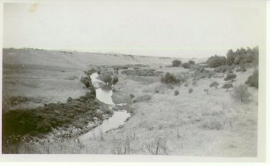
Photograph
VIEW OF CREEK AT CLUNESVIEW OF CREEK AT CLUNESlocal history, photography, photographs, clunes, landscape -
 Bendigo Historical Society Inc.
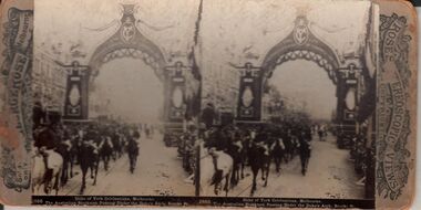
Photograph - HARRIS COLLECTION: STEREOSCOPIC VIEWS, 1908
Rose Stereoscopic Views. 1. Duke of York Celebrations Melbourne. 2. Duke of York Celebrations Melbourne. 3. Delhi Durbar State Entry into Delhi. Camels in the Procession. 4. The Splitters Falls, Gulf Stream, near Stony Creek, Grampians, Vic Australia,Rose Stereoscopic Viewsphotography, viewers -
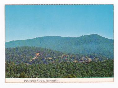 Marysville & District Historical Society
Postcard (item) - Colour postcard, Nucolorvue Productions Pty. Ltd, Panoramic View of Marysville, Pre 2009
A colour photograph of the view of Marysville from Barton's Lookout which is near the Cumberland Valley in Victoria.A colour photograph of the view of Marysville from Barton's Lookout which is near the Cumberland Valley in Victoria. The Cumberland Valley is notable for its giant mountain ash (Eucalyptus regnans) trees within the Cumberland Memorial Scenic Reserve, and relics from former sawmills and gold mining. The Big Culvert is located nearby on the Marysville-Woods Point Road, which was historically part of the Yarra Track. Cambarville, which is in the Cumberland Valley, was established as a timber mill town in the 1940s. Timber mill owners A Cameron and FJ Barton named Cambarville. They established the mill to salvage timber from trees destroyed in the 1939 bushfires. Cambarville was impacted by the 2009 Black Saturday bushfires and any remaining structures were destroyed. Barton's Lookout was named after a member of the Barton Family who were amongst Marysville's earliest pioneering families. This postcard was produced by Nucolorvue Productions as a souvenir of Marysville.NU-COLOR-VUE/ OF/ AUSTRALIA MARYSVILLE, VICTORIA Panoramic View of Marysville from/ CUMBERLAND. PLACE/ STAMP/ HERE POST CARD NUC.171 - NUCOLORVUE PRODUCTIONS PTY. LTD./ COPYRIGHT Printed in Australia Hi There! how are you? fine I hope....Hows school/ treating you?/ Isn't it beautiful now Autumns back again./ You'll have to come up soon and see us, where/ really you/ Ok! it beautiful, the air so fresh and/ clean it makes you want to cry. There are/ so many magnificent and brill marysville, barton's lookout, victoria, nucolorvue productions, postcard, souvenir, cumberland valley, cumberland memorial scenic reserve, big culvert, marysville-wood's point road, yarra track, mining, timber mills, a cameron, fj barton, cambarville, 1939 bushfires, 2009 black saturday bushfires -
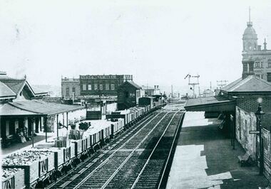 Camberwell Historical Society
Photograph, Camberwell Victoria, view of the railway station, c. 1930
Print of photograph of Camberwell Railway Station looking west. Inscription states 'Camberwell Victoria, view of the railway station, c. 1930' Camberwell Victoria, view of the railway station, c. 1930camberwell -
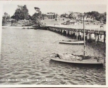 Phillip Island and District Historical Society Inc.
Photograph, Murray Views, Cowes pier
Tourist postcardSmall black & white photo of the Cowes Pier, two small yachts and views of main beach, jetty shed, band rotunda and Isle of Wight Hotel.View from the pier, Cowes, Phillip Islandcowes pier phillip island, isle of wight hotel, cowes jetty, cowes jetty shed, band rotunda, cowes -
 Melbourne Water
Photographic View Book, The Melbourne & Metropolitan Board of Works - Water Supply, Sewerage etc. ...Photographic Views, 1908
In 1891 The Melbourne and Metropolitan Board of Works (MMBW) was formed and became responsible for Melbourne's water supply. Melbourne had grown to a city of half a million people. To provide water to this rapidly growing city (especially the eastern suburbs), and to supplement the 1857 Yan Yean Reservoir, Melbourne's first water supply, the Watts River (near Healesville) was tapped. It supplied water to Melbourne, via the Maroondah aqueduct. In May 1892 the MMBW's first engineer-in-chief, Mr William Thwaites began construction on Melbourne's sewerage system. A treatment farm was built at Werribee and a pumping station was built at Spotswood (now the site of the Scienceworks Museum) to send the city's waste to Werribee. The first Melbourne homes were connected to the sewerage system in 1897. This book showcases the MMBW's infrastructure achievements and documents costs, requirements and key personnel involved in the development of the water supply and sewerage schemes.The introduction states "The water supply sources and headworks are in many cases situated in remote places and the sewerage works are chiefly underground. The Board has therefore resolved that these photographs of some of the scenes and works should be collected and bound for general information. August 1908" This book is in excellent condition and provides a detailed insight into the previous 17 years of work and the Board personnel of the MMBW leading up to 1908. It is of historical importance to the history of Melbourne for the photographic documents of places that were not generally open to the public, and for Melbourne Water in its detailed history of the MMBW in the early twentieth century. Photographic view book with hard khaki coloured cardboard cover and blue fabric binding. 120 Pages. Glossy paper with black and white plates and text about the MMBW, and scenic views and places of interest in association with the MMBW. The Melbourne & Metropolitan Board of Works - Water Supply, Sewerage etc. ...Photographic Views...mmbw, board members, sewerage, water supply, historic views, photographs -
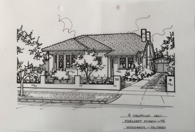 Kew Historical Society Inc
Drawing - Property Illustration, Margaret Picken, 4 View Point, Kew, 1995
After training as a Cartographic Draftsman within the mining industry, I worked as a property illustrator for real estate firms in the eastern suburbs of Melbourne for 22 years from 1983. I initially photographed houses with a Polaroid camera and made a 'thumbnail' sketch while there. The photos were used to scale off a sketch in pencil and then that sketch was overlaid with drafting film and the 'pen and ink' completed. The pens I used were the Rotring ‘Rapidigraph’ drafting pens. The ink was also made by Rotring (German).The film was ‘Rapidraw’, polyester drafting film, double matte. It takes a very fine line and doesn’t bleed. As well as house sketches, there were often floor plans and site plans ordered. Aerial sketches were ordered when the property needed an overall view. (Margaret Picken, 2020)This drawing is one of a series created by Margaret Picken for a number of real estate agents in Melbourne between 1983 and 2005. Each work is signed and dated by the artist.Gift of Margaret Picken, 2020Pen and ink architectural drawing on drafting film of 4 View Point, Kew by Margaret Picken.4 VIEW POINT, KEW / MARGARET PICKEN ~95 / WOODARDS ~ HAWTHORNartist -- margaret picken 1950-, architectural drawings -- houses -- kew (vic.), 4 view point - kew (vic) -
 Phillip Island and District Historical Society Inc.
Photograph - Post Card, Early 1900's
Donated by G. HaywoodBlack & White Postcard of view at Cape Woolamai. Land mass in foreground with sea in background."The Rose Series, P. 2789" "View at Cape Woolamai, Phillip Island, Vic."view cape woolamai, phillip island, g haywood -
 Clunes Museum
Photograph, 1865
VIEW IN TOWNSHIP CLUNES, SOUTH EAST. PERIOD 1865. TAKEN FROM HILLSIDE BELOW CAMP PARADE, VICINITY MR. SWANTON'S HOUSE PHOTOGRAPH OF TOWNSHIP OF CLUNES, SOUTH EAST .1 SEPIA PHOTOGRAPH MOUNTED ON CARDBOARD. .2 BLACK AND WHITE PRINT .3 SEPIA PHOTO PRINT .4 BLACK AND WHITE PHOTO PRINT .5 BLACK AND WHITE PHOTO PRINT HOUSES SURROUNDED BY PICKET FENCES, POPPET LEGS AND CHIMNEY STACK.VIEW IN TOWNSHIP CLUNES. SOUTH EAST.local history, photography, photographs, clunes township -
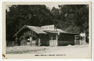 Marysville & District Historical Society
Postcard (Item) - Black and white postcard, Murray Views, Murray Views No. 6. "Log Cabin", Marysville, Vic, 1946
A black and white postcard of The Log Cabin in Marysville in Victoria.A black and white postcard of The Log Cabin in Marysville in Victoria. The Log Cabin was built by Thomas Henry Branchflower who had arrived from England late in 1921. It was built for Gwendoline Pitman after the death of her father Clarence Pitman and the disappearance of her sister Olive in July 1926. Gwendoline operated an artist and souvenir shop in the newly built Log Cabin in partnership with Peter Mackey who was a Melbourne optician and artist. This postcard was produced by Murray Views in Gympie, Queensland as a souvenir of Marysville. POST CARD STAMP REAL PHOTOGRAPH PRODUCED IN/ AUSTRALIA BY MURRAY VIEWS, GYMPIE, Q.the log cabin, thomas henry branchflower, gerald branchflower, marysville, mary chain, gwendoline pitman, clarence pitman, kooringa guesthouse, olive pitman, wilbur anderson, peter mackey, murray views no. 6., postcard, souvenir -
 Warrnambool and District Historical Society Inc.
Postcard - Views of Warrnambool
Pictures depicting scenes of Warrnambool & District. 9 pictures are, The Beach. Hopkins River. Thunder Point. Liebig St. Botanical Gardens. Breakwater and pier. Hopkins River. Soldiers Memorial. Hopkins Falls.A typical souvenir postcard from the 1930'sOblong postcard with flip down views of Warrnambool from a purse with two kittensValentine's Mail Novelty Post Card; Good Luck And a Bagful of Views from WARRNAMBOOLwarrnambool, hopkins river, warrnambool breakwater, warrnambool postcards, postcards, hopkins falls, thunder point, soldiers memorial -
 Glenelg Shire Council Cultural Collection
Postcard - Postcard - Nelson, Victoria, n.d
Coloured photo postcard, aerial view of Nelson, Victoria, showing the bridge, township and river mouth. Rose Series De Luxe colorview NO 1213Back: Maker details. 'Aerial view of Nelson Victoria'postcard, nelson -
 Melbourne Legacy
Slide, Operation Firewood - Eildon Reservoir, 1960s
Colour slide of a view of Lake Eildon from Big River Road. It was during Operation Firewood. Legatees would organise collection of wood from the country and distribute it to widows in metropolitan Melbourne. Other slides show the cutting and loading of wood and delivery to widows in metropolitan Melbourne. Was with many other slides taken in the 1950s and 1960s. The slides have been photographed to make digital images and moved to archive quality sleeves. In many cases the original images were not well focussed and the digital image the best available.A record of Legacy helping widows by sourcing, supplying and delivering firewood. When open fires were the main source of heating, a load of firewood and help moving it, would have been very important to the widows.Colour slide of a view of Lake Eildon during Operation Firewood in brown Anscochrome cardboard mount.Printed on front in red ink 'Anscochrome / View from this side / Made in Australia'. Hand written on front 'Eildon Reservoir from Big River Road' in blue pen. Printed on reverse in red ink 'Processed by Verycolor photo labs. Melbourne, Victoria'.operation firewood, trees, forest -
 Lakes Entrance Historical Society
Postcard, Bulmer H D, 1950c
Also one other postcard same donated by M & V Carpenter in spares box.Black and white postcard of the Princes Highway Jemmys Point, showing Bullock Island between North Arm and Cunninghame Arm, distant view of the entrance from Bass Strait to the Gippsland Lakes. Post and rail fence along roadside. Lakes Entrance VictoriaPrinces Highway and a view of the Entrance vegetation, roads and streets -
 Ballarat Tramway Museum
Slide - 35mm slide/s, Ben Parle, 8/04/1958 12:00:00 AM
Kodachrome Transparency - 35mm slide - cardboard mount, with one side with red border and words "Kodachrome Transparency / Processed by Kodak" top and bottom. Photo taken by Ben Parle 8/4/1958, date stamped onto slide. Has slide No. "20" stamped in red in top corner. Photo of Ballarat 12, Ripon St, just north of Sturt St, outbound to View Point. Tram has destination of View Point. "View Point line" / "8-4-58"tramways, trams, view point, ripon st, tram 12 -
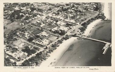 Phillip Island and District Historical Society Inc.
Photograph - Post Card, Unknown
Donated by Stan McFee from the Keith McIlwraith Collection.Black & White postcard showing an aerial view of Cowes Town Centre, beach and pier."The Rose Series P. 1022" "Aerial view of Cowes, Phillip Island." "Airspy Photo".cowes phillip island, cowes foreshore and pier, phillip island, stan mcfee, keith mcilwraith collection -
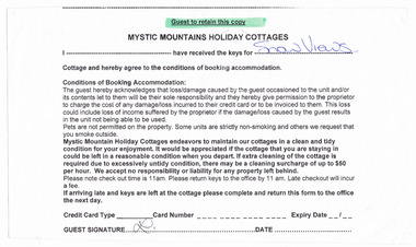 Marysville & District Historical Society
Ephemera (item) - Receipt for keys, MYSTIC MOUNTAINS HOLIDAY COTTAGES, Unknown
A receipt for keys received by a guest staying at Snow Views cottage in Marysville. Snow Views cottage was managed by Mystic Mountains Holiday Cottages in Marysville.A receipt for keys received by a guest staying at Snow Views cottage in Marysville. Snow Views cottage was managed by Mystic Mountains Holiday Cottages in Marysville.marysville, victoria, australia, accommodation, mystic mountains holiday cottages, aspen, barree, beauty spot, callista cottage, clouds hill, ell-jay, kings lodge, kookaburra cottage, larnook, lomatia lodge, mountain view, oakmont, snow views, settlers, tenadry, the springs, the ville, valley view, waratah, hillcrest house, b&b, receipt -
Glenelg Shire Council Cultural Collection
Photograph - Photographic print of a rephotographed photograph, c. 1970
Photographic print of a rephotographed photograph. Image shows view of harbour from Whalers Point/Bluff, Baths, piers, Cliff Street, Battery Point in Portland Victoria.Front: 'View from Whalers Point' - green ink -
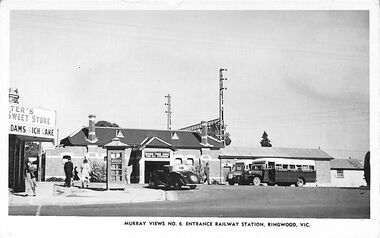 Ringwood and District Historical Society
Photograph/Postcard, Postcard and souvenir photograph - Murray Views No.6 Entrance Railway Station, Ringwood, Vic. Circa 1948
Black and white "Murray Views" postcard and souvenir photograph - 1948 handwritten on back. 1948 handwritten on back. Postcard - Real Photograph Produced in Australia by Murray Views, Gympie, Q. -
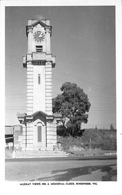 Ringwood and District Historical Society
Photograph/Postcard, Postcard - Murray Views No.2 - Ringwood Main St and Clocktower in original position
Black and white "Murray Views" postcard - Ringwood memorial clock tower, cnr Maroondah Highway & Warrandyte Road, looking south towards railway line.Front: "Murray Views No. 2 Memorial Clock, Ringwood, Vic." Back: "1948" handwritten. "Real Photograph Produced in Australia by Murray Views, Gympie, Q." -
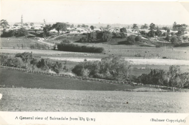 Lakes Entrance Historical Society
Postcard - view of Bairnsdale Victoria, Bulmer, 1940 c
Black and white postcard showing general view of Bairnsdale from Wy Yung water tower and St Marys church tower Bairnsdale VictoriaA General view of Bairnsdale from Wy Yung Bulmer copyrightroads and streets, township -
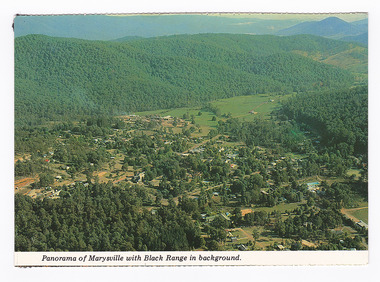 Marysville & District Historical Society
Postcard (item) - Colour postcard, K. & H. Ellis, Panorama of Marysville with Black Range in background, Pre 2009
A colour photograph of a view of Marysville in Victoria.A colour photograph of a view of Marysville in Victoria. The photograph has been taken from one of the many lookouts that surround Marysville.Panorama of Marysville with Black Range in background. Colorscans MARYSVILLE - VICTORIA Panorama of Marysville with Black/ Range in background. c PUBLISHED & PRINTED BY COLORSCAPES PUBLISHING PTY LTD 118-120 BRIGHTON STREET RICHMOND 3121 Supa-vu/ cards Photographed and Distributed by:/ K. & H. ELLIS - 35 Old Warburton Road/ Warburton 3799 20-1-81/ Dear Mum/ Just a line/ to let you know we/ have settled in here./ Its a nice park not to/ big, with a river in/ behind the van. (its/ more like a swift/ running creek, the/ kids are really enjoying/ it. There are plenty of/ walks to go on, up here/ tracks everywhere./ Hows the cooler going/ keeping you cool?/ We are able to say here until/ Sunday./ See you Mum/ Love Lois, Tom,/ & Kids. Mrs A. McTaggart/ 2 Frederick Street/ Kyabram Vic/ 3620. On reverse of postcard are 5 black marks; one in each corner and one in the centre from where the postcard has been removed from an album.marysville, victoria, postcard, souvenir, k & h ellis, colorscans publishing -
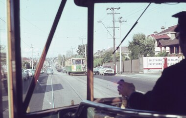 Melbourne Tram Museum
Slide, Keith Caldwell, 25/04/1964 12:00:00 AM
Agfa colour slide, blue / white plastic mount, photo by Keith Caldwell of the view from a Y1 tram in Riversdale Road, just east of Glenferrie Road with Y1 612 (city) coming the other way. 25/4/1964In ink "View from T1 25.4.64"trams, tramways, y1 class, riversdale rd, tram 612 -
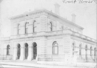 Stawell Historical Society Inc
Photograph, Court House in Patrick Street 1878
Court House Patrick Street 1878B/W front angled view of substancial Two story brick building, with three archways and wrought iron fence, to either side of the archways. This builing is the current courthouse.Victorian Views. C. Herbert, Photo. Stawell 1878stawell building, courthouse -
 Kew Historical Society Inc
Photograph - 'Raheen', Studley Park Road, 1979
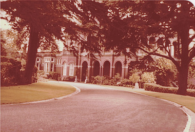
In 1979, a series of photographs of significant gardens in Kew (Victoria) were taken during a tour by Peter Watts, Historic Gardens Coordinator of National Trust Victoria. These were later purchased to add to the collection. In the case of each photo the colour had badly degraded over time. Original colour (degraded) positive photograph of 'Raheen', Studley Park Road, , Kew. A view of the south facing facade. Annotated in ink on reverse: "Raheen Front View with sweeping driveway / Oct 1979"gardens -- kew (vic.), raheen, studley park road -- kew (vic.) -
 Orbost & District Historical Society
black and white photograph, late 19th / early 20th century?
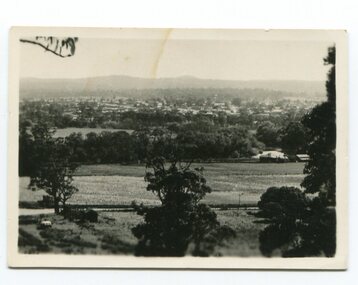
This photograph shows a distant view of the Orbost township taken from Grandview Lookout at Newmerella. It appears to have been taken before the railway line was there.This is a pictorial record of early Orbost.A small black / white photograph of the Orbost township taken from Grandview Lookout , Newmerella. The main road can be seen below with paddocks of crops on both sides.on back - "Distant View, Orbost from Grandview"orbost-township-c19th grandview-lookout orbost-flats-paddocks -
 Phillip Island and District Historical Society Inc.
Photograph - Post Card, Early 1900's
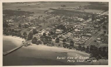
Photograph donated by Les JonesBlack & White postcard of an aerial view of Cowes. Jetty on the left - tree lined Thompson Avenue - Isle of Wight Hotel on the Esplanade left of Thompson Avenue and Bayview Guesthouse on the right on the Esplanade. Township and farmland."Aerial View of Cowes, Phillip Island. No. 147"aerial view of cowes phillip island, cowes township, part cowes township - cowes beach and jetty, phillip island, les jones -
 Camberwell Historical Society
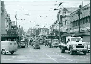
Photograph, Camberwell, Victoria, view of Burke Road and stores, c. 1950
Print of photograph looking north up Burke Road, with Rivoli Cinema on the right. Inscription 'Camberwell, Victoria, view of Burke Road and stores c. 1950' Camberwell, Victoria, view of Burke Road and stores c. 1950camberwell