Showing 157 items
matching wangaratta and district
-
 Wodonga & District Historical Society Inc
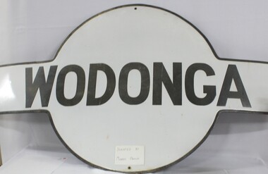
Sign - Wodonga Railway Station Sign
The Wodonga rail line and railway station opened in November 1873 when the section of the line from Wangaratta was completed. The expansion of the railways to the northeast of Victoria occurred after the Victorian Government took over the railways in 1867 and the trains serviced large towns such as Seymour, Wangaratta and Wodonga, as well as smaller towns along the way. The original Wodonga Station, located in the middle of the city, was closed on 9 November 2008 as part of the Wodonga rail bypass project. The station platform was largely removed and the area has been redeveloped as part of the Junction precinct.This sign has local and state historical significance as the railways played a critical part in opening up the interior of Australia for commerce, transportation and settlement. It enabled Wodonga to develop as an important centre for social and commercial purposes.A metal railway station platform sign, Wodonga is painted in black in the centre circle against an oblong cross piece"WODONGA"railways, wodonga railway station, victoria railways, wodonga -
 Wodonga & District Historical Society Inc
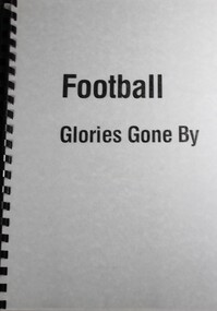
Booklet - Football Glories Gone By, Strad Jones, C. 1940
Handwritten information from the Strad Jones collection. Detailed explanation of the formation of Australian Rules football leagues and competition in Northeast Victoria. It provides information about key families in the Rutherglen area as well as other clubs in what became the Ovens and Murray Football League. Basic rules of football at the time are explained in the introduction. Details of meetings, games and game data, key events and premiership and medal winners are included. Covers period from 1890 to 1940. Clubs referenced in this publication include the initial members of Lake Rovers, Excelsior, Chiltern, Howlong, Corowa, Barnawartha and Border United. Member clubs changed over this period with the inclusion of Beechworth, Wodonga, Wangaratta and Benalla at different stages.Spiral bound containing hand written record and informationnon-fictionHandwritten information from the Strad Jones collection. Detailed explanation of the formation of Australian Rules football leagues and competition in Northeast Victoria. It provides information about key families in the Rutherglen area as well as other clubs in what became the Ovens and Murray Football League. Basic rules of football at the time are explained in the introduction. Details of meetings, games and game data, key events and premiership and medal winners are included. Covers period from 1890 to 1940. Clubs referenced in this publication include the initial members of Lake Rovers, Excelsior, Chiltern, Howlong, Corowa, Barnawartha and Border United. Member clubs changed over this period with the inclusion of Beechworth, Wodonga, Wangaratta and Benalla at different stages.australian rules football, football northeast victoria, ovens and murray football -
 Department of Energy, Environment and Climate Action
Pye Portable radio and charger
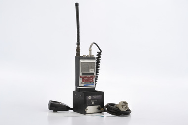
After the 1939 bushfires, the Forests Commission Victoria invested heavily in a radically new communications network. After suffering some inevitable delays due to the war, radio VL3AA switched into full operation in October 1945 proudly beaming out 200 watts across the State. But by today’s standards, the technology was primitive and the reception poor unless the user was on a high point somewhere. The radio signal was "line-of-sight" and bounced between fire towers and relay transmitters across the mountains back to the District offices. The advent of solid-state electronics in the 1960s replaced the more delicate valve sets which enabled greater use of vehicle mounted radios. The Commission continued to research, develop and build new radios at its many workshops around Victoria. The network was supported by a large team of skilled radio technicians. The more secure and versatile State Mobile Radio (SMR) digital trunk system came into operation in about 1995. Upgraded Tait Radios were purchased in 2014 after recommendations of the 2009 Bushfires Royal Commission. But it was the convergence of separate technologies such as 5G mobile phones, high-capacity and light-weight lithium batteries, Wi-Fi, the ever-expanding internet, cloud data storage, digital cameras, GPS, personal organisers and hundreds of supporting Apps into powerful smartphones and tablets which revolutionised bushfire communications from the mid-2000s. Portable radio with handset and chargerConservation Forests and Lands Wangarattabushfire, radios, forests commission victoria (fcv) -
 Wangaratta RSL Sub Branch
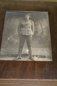
Photograph, Talma & Co, John "Jack" AMBROSE MM
Unknown WW1 soldier ................. 22/11/2018 ..........due to its poor condition the photograph was removed from its timber frame revealing below the photograph the handwritten words "Jack Ambrose married a girl Chick"..... identified as Ethel Maud CHICK Soldier identified as John AMBROSE MM 1132 Labourer of Carboor who served on the western front in France during the First World War. Joined 19/2/1916 aged 23 years and 4 months Born and enlisted at Wangaratta Embarked on 3/6/1916 on HMAT Persic. Served with 5/37Battalions. Wounded on 3 occasions, returning to Australia on 27/7/1919. Next of Kin - Edward Henry PAYNE (Cousin) of Carboor. Jack and Edward were both cousins to Sir Edward "Weary" Dunlop.By identifying this originally unknown soldier to be John "Jack" AMBROSE has revealed links to the children of Edward Samuel PAYNE and his wife Catherine Marie nee WALPOLE. Jack's mother Ida Elizabeth AMBROSE nee PAYNE is the elder sister of Alice Emily Maud DUNLOP nee PAYNE mother of Sir Ernest Edward "Weary" DUNLOP, twin sisters Lily May and Violet Minnie PAYNE who both served as Nurses during the First World War along with youngest brother Alfred Ernest PAYNE 1256. The latter three together with Jack AMBROSE are listed on the Wangaratta and District Victory Roll. Colonel Sir Ernest Edward "Weary" Dunlop, AC, CMG, OBE was born at Wangaratta (12 July 1907 – 2 July 1993) and an Australian Surgeon renowned for his leadership while being held prisoner by the Japanese during the Second World War.Framed timber mounted photograph of unknown WW1 Soldier - now identified to be John AMBROSE MM 1132 of CarboorBelow photograph handwritten "Jack Ambrose married a girl Chick" Rear Miss S Wright Farm Hill Carboor East via Wangarattajohn ambrose, 5th battalion ww1, carboor, wangaratta, weary dunlop -
 Wodonga & District Historical Society Inc
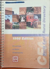
Book - North East Rural Directory 1998
The CFA North East Rural Directory for Regions 23 and 24 was designed to assist fire brigades and other emergency services in responding to calls in the North East region of Victoria. Its purpose was to minimize response times to emergency situations by providing accurate and detailed information about all of the localities in the regions. District 23 is based at Wangaratta and Extends as far south as Woods Point. District 24 is centred in Wodonga and extends past Corryong to the New South Wales border following the Murray River. It also includes Falls Creek and Mount Hotham.A spiral bound volume including colour topographic maps and illustrations of North East Victoria. The cover features a collage of colour photo of North East Victoria including a CFA firefighter in a truck with members of his family beside it. The book also features a key map, explanation of map references and symbols, localities index. Alphabetical road indexes for Wodonga, Albury, Wangaratta and Benalla as well as township maps and alphabetical road indexes for smaller communities are included.The CFA North East Rural Directory for Regions 23 and 24 was designed to assist fire brigades and other emergency services in responding to calls in the North East region of Victoria. Its purpose was to minimize response times to emergency situations by providing accurate and detailed information about all of the localities in the regions. District 23 is based at Wangaratta and Extends as far south as Woods Point. District 24 is centred in Wodonga and extends past Corryong to the New South Wales border following the Murray River. It also includes Falls Creek and Mount Hotham.emergency management north east victoria, cfa region 24, cfa wodonga, cfa region 23 -
 Wodonga & District Historical Society Inc
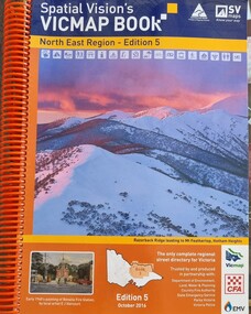
Book - Spatial Vision's VICMAP BOOK 2016 - Northeast Region, Spatial Vision Innovations Pty Ltd, 2016
This edition of Spatial Vision's VicMap Book North East Region was published in October 2016 and provides detailed topographic maps for the region. It was used by emergency services and various agencies, including the Country Fire Authority (CFA). It covers areas including Wodonga, Albury, Wangaratta, and beyond, including national parks and recreation areas. Text on the cover states that the volume is "Trusted by and produced in partnership with: Department of Environment, Land, Water & Planning, Country Fire Authority, State Emergency Service, Parks Victoria, Victoria Police".A spiral bound volume of 409 pages including colour topographic maps and illustrations of North East Victoria. The cover features a colour photo of Razorback Ridge leading to Mount Feathertop, Hotham Heights, Victoria. It also features an index map inside the front cover, a legend, road index, and locality index.This edition of Spatial Vision's VicMap Book North East Region was published in October 2016 and provides detailed topographic maps for the region. It was used by emergency services and various agencies, including the Country Fire Authority (CFA). It covers areas including Wodonga, Albury, Wangaratta, and beyond, including national parks and recreation areas. Text on the cover states that the volume is "Trusted by and produced in partnership with: Department of Environment, Land, Water & Planning, Country Fire Authority, State Emergency Service, Parks Victoria, Victoria Police".emergency management north east victoria, state emergency service, cfa wodonga -
 Wodonga & District Historical Society Inc
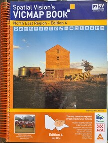
Book - Spatial Vision's VICMAP BOOK 2014 - North East Region
This edition of Spatial Vision's VicMap Book North East Region was published in May 2014 and provides detailed topographic maps for the region. It was used by emergency services and various agencies, including the Country Fire Authority (CFA). It covers areas including Wodonga, Albury, Wangaratta, and beyond, including national parks and recreation areas. Text on the cover states that the volume is "Trusted by and produced in partnership with: Department of Environment, Land, Water & Planning, Country Fire Authority, State Emergency Service, Parks Victoria, Victoria Police".A spiral bound volume of 409 pages including colour topographic maps and illustrations of North East Victoria. The cover features a colour photo of the old flour mill at Milawa, Victoria. It also features an index map inside the front cover, a legend, road index, and locality index.non-fictionThis edition of Spatial Vision's VicMap Book North East Region was published in May 2014 and provides detailed topographic maps for the region. It was used by emergency services and various agencies, including the Country Fire Authority (CFA). It covers areas including Wodonga, Albury, Wangaratta, and beyond, including national parks and recreation areas. Text on the cover states that the volume is "Trusted by and produced in partnership with: Department of Environment, Land, Water & Planning, Country Fire Authority, State Emergency Service, Parks Victoria, Victoria Police".emergency management north east victoria, cfa wodonga