Showing 203 items matching "warrandyte bridge"
-
 Ringwood and District Historical Society
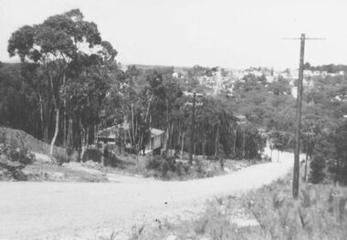
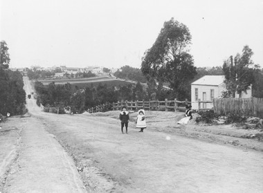
Photograph, View of Glenvale Road, Ringwood, looking towards Loughnan Road at bridge 1964
See Also #25Written on back of photograph, "1964 - View of Glenvale Road looking towards Loughnan Road at bridge. Original supplied by Garrett Gundry." -
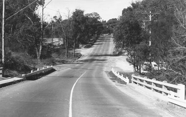
 Ringwood and District Historical Society
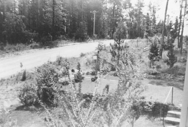
Photograph, View of Glenvale Road near top of first hill from bridge looking north east 1964
See Also #25Written on back of photograph, "Copy of a 1964 view of Glenvale Road near top of first hill from bridge looking north east. Original supplied by Garrett Gundry." -
 Ringwood and District Historical Society
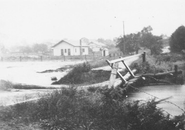
Photograph, Mullum Creek in flood, Ringwood. Adelaide St. Bridge to Reynolds Ave washed away, 1931
Catalogue card reads, "Mullum Creek in flood. Adelaide St. Bridge to Reynolds Ave washed away, 1931". Typed below photograph, "Adelaide St. bridge, to Reynolds Ave washed out in 1931 (Bridge not replaced). 1934?" -
 Ringwood and District Historical Society
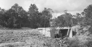
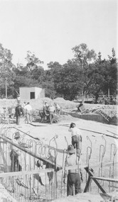
Photograph, Bridge over Mullum Creek under construction, Oliver Street. 1963
2 photographsWritten on back of photograph, "Bridge over Mullum Creek, Oliver Street. 17/11/1963" -
 Ringwood and District Historical Society
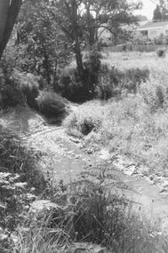
Photograph, Mullum Creek, 50 yards west of bridge in Ringwood Street Ringwood. May 1971
Writing on back of small photograph reads, "May 1971. Mullum Creek, 50 yards west of bridge in Ringwood St." Enlargement reads, "Mullum Creek looking west from bridge in Ringwood St. July 1972". -
 Ringwood and District Historical Society
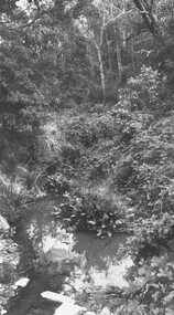
Photograph, Mullum Creek, 75 yds. east of bridge 1972
Written on backing sheet, "Mullum Creek, 75 yds. east of bridge 1972". -
 Ringwood and District Historical Society
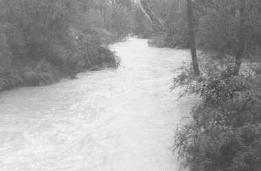
Photograph, Mullum Creek in flood, July 1963. Taken from foot bridge at end of Adelaide St., Ringwood
See also 2982Typed below photograph, "Mullum Creek in Flood - 1963". Other photographs read, "Mullum Creek in flood, July 1963. Taken from foot bridge at end of Adelaide St." -
 Ringwood and District Historical Society
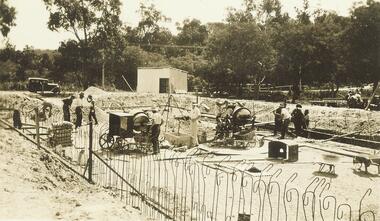
Photograph, Building the old Ringwood baths in Ringwood St 1934
Black and white photograph. 2 copies- 1 large, 1 small.Typed below photograph, "Building the old Ringwood baths in Ringwood St. The car is in Ringwood St. and the bridge over the Mullum Creek can be seen. 1934". -
 Ringwood and District Historical Society
Photograph, Heathmont (from railway bridge), 1967
Catalogue card reads, "Heathmont, 1967". -
 Ringwood and District Historical Society
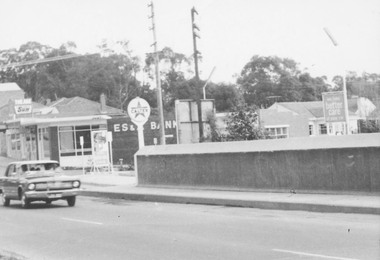
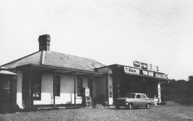
Photograph, Burnt Bridge Store (undated but post 1962)
Written below photograph, "Burnt Bridge Store". No date, but car has been identified by Peter Fry as an EJ Holden, which was produced by General Motors-Holden's in Australia from 1962 to 1963.[Introduced in July 1962, So this photo is sometime after 1962 -
 Ringwood and District Historical Society
Photograph, Pitt St. Ringwood, from clock tower. 1960
Showing Wantirna Rd railway bridge and trainWritten on back of photograph, "Pitt St. from clock tower. 1960". -
 Ringwood and District Historical Society
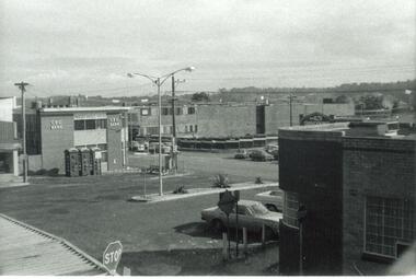
Photograph, Heathmont 1965. State Savings Bank to left. Bridge on right
Typed below photograph, "Heathmont 1965. State Savings Bank to left. Bridge on right". -
 Ringwood and District Historical Society
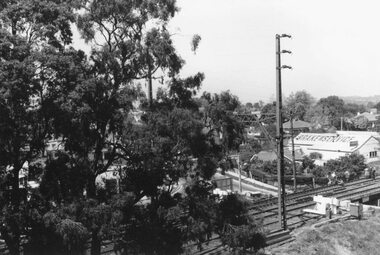
Photograph, Town hall site after demolition, from railway bridge. Ringwood. ca 1971-73
Undated, but after town hall demolition (1970) and others in this SS358 series are 1971-73Written on back of photograph, "Town hall site from railway bridge." -
 Ringwood and District Historical Society
Document, Council flood relief for Mullum Creek flood in Ringwood in 1934
Hand written letters to Ringwood Council re flood relief.Correspondence to Council from Ratepayers asking for flood relief resulting from the flood damage in the vicinity of Harrison Street bridge over Mullum Creek in 1934. -
 Ringwood and District Historical Society
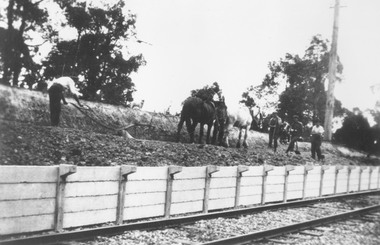
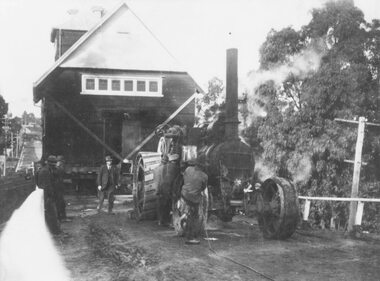
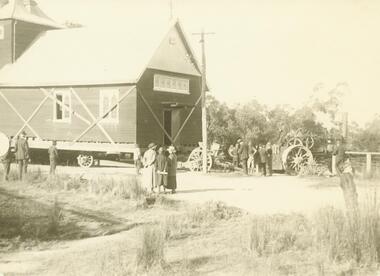
Photograph, Construction of Heathmont railway station by the Wieland family, 1926. Four photographs
3 large black and white photographs (1957-001 to -003) 25x15cms mounted on white board, plus one small B&W photograph (1957-004) 11.2 c 6.7 cms)On 1957-001: Typed below photograph, "Building Heathmont railway station platform by Wieland brother 1926. Note use of plough." On 1957-002: Typed below photograph, "Building Heathmont railway station platform by Wieland brother 1926. Heathmont Rd in Background." On 1957-003: Typed below photograph, "Building Heathmont railway station platform by Wieland brother 1926. Canterbury Rd in Centre Background, Bridge to left." On Reverse of 1957-004, handwritten: "All the men in Heathmont made the Heathmont Station. The one with X over him is dad. This was taken when they were making it before it was burned down, Ruby, xxxxxxxXXX" -
 Ringwood and District Historical Society
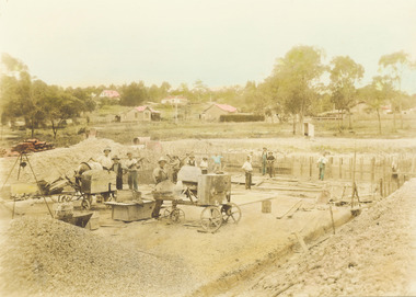
Photograph, Construction of Ringwood baths, Miles Avenue. Construction began in January 1934 and the pool was officially opened in November that year
Coloured photograph. Photograph taken by "Mervyne" Ringwood Studios."Written on back of photograph" Ringwood baths under construction. Photo taken from corner of Ringwood St & Miles Ave. Houses just above baths are in Reynolds Ave & top left in Warrandyte Road. Top centre- corner Warrandyte Road & Woodside Ave. White railing centre right is on the bridge across Mullum Creek. Adelaide St ran from Maroondah Highway to Reynolds Ave. Bridge later washed away- 1931. -
 Ringwood and District Historical Society
Photograph, Ringwood baths under construction, 1934. White railing at centre right is on the bridge across Mullum Creek
Sepia photograph"Written on back of photograph" Building baths Ringwood St. Looking Nth West. -
 Ringwood and District Historical Society
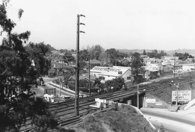
Photograph, View from Ringwood Clocktower overlooking Wantirna Road railway bridge and Thanet Street corner - Dec. 1969
Black and white photographWritten on back of photograph: "Wantirna Rd. from clocktower, 1969." -
 Ringwood and District Historical Society
Photograph, View from Ringwood Clocktower overlooking Wantirna Road railway bridge and Thanet Street corner - Dec. 1969
Black and white photographWritten on back of photograph: "Wantirna Rd bridge. from clocktower, 1969". Thanet Street corner. -
 Ringwood and District Historical Society
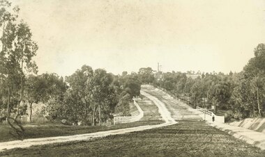
Photograph, Maroondah Highway East, Ringwood- 1900. Sandy Creek Bridge, Maroondah Hwy
3 photographs ( 2 large black and white, 1 small sepia)Written on all copies: "New Sandy Creek Bridge". Typed below large photograph: "Maroondah Highway Ringwood looking east. To right of bridge is now Ringwood Lake. Mount Dandenong Road turnoff to right at top of rise with antimony mine in background - 1900". -
 Ringwood and District Historical Society
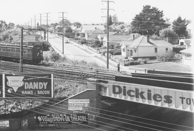
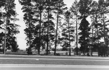
Photograph, Croydon West High School off Cutts Avenue and Maroondah Hwy, Ringwood - November, 1969
Written on backing sheet, "West Croydon School (In Ringwood municipality)". November 1969. The area behind the pine trees was used as a training ground by the Wilhelmina Soccer Club, later called Ringwood City SC and Ringwood FC. It was later sub-divided and the two streets named Wilhelmina and Juliana Courts, in honor of Wilhelmina, Queen of the Netherlands, and her daughter, Juliana, later succeeding her as Queen. The Burnt Bridge Shopping Centre can be seen in the far west on one of the images. -
 Ringwood and District Historical Society
Photographs, 1979-80 MMBW pipe line project at Hubbard Reserve, North Ringwood � Track down to creek bridge
Part of a 43-photo record of the MMBW�s engineering feat in drilling a 12 inch pipe line up to 40 feet deep through rock hardened by volcanic action associated with geological fault that occurs along the line. The work took place from October 1979 to May 1980 on the southern boundary of Hubbard Reserve, North Ringwood. The collection was presented to the Ringwood Historical Research Group by J Clarke on 9th June 1980.E565 N12 13 May 1980 A43 My old track down to the bridge over the creek. The pipe line went to the right of the big tree 40-foot down. -
 Ringwood and District Historical Society
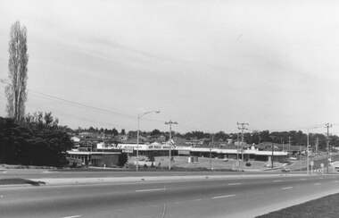
Photograph, Maroondah Highway East, Ringwood- 1969. Burnt Bridge Shopping Centre, cnr Maroondah Hwy and Beaufort Road
Black and white photographWritten on back of photograph: "Site of Burnt Bridge Hotel - (later a store). Nov 1969." -
 Ringwood and District Historical Society
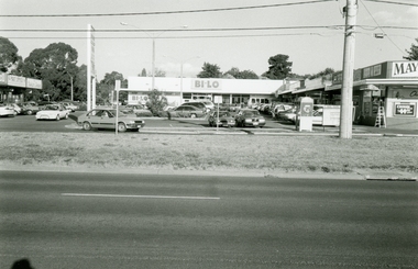
Photographs, Burnt Bridge Shopping Centre, East Ringwood in 1999
-
 Ringwood and District Historical Society
Photograph, C of E jambed on bridge over Mullum Creek, W'dyte Rd. Ringwood 1924
Written on back of photograph, "C of E jambed on bridge over Mullum Creek, W'dyte Rd. 1924." Typed below another copy: "Moving Church of England, Ringwood. Stuck on bridge over Mullum Creek in Warrandyte Rd. 1924". Written on backing sheet, "Church of England being moved from C/r Pratt Street and Maroondah H'way to rear post office via Warrandyte Rd., Reynolds Av. and Ringwood Street." -
 Ringwood and District Historical Society
Photograph, Church of England relocation: About to cross bridge over Mullum Creek, Warrandyte Rd (undated)
... Church of England relocation: About to cross bridge over... which this photograph was taken reads, "About to cross bridge... to cross bridge over Mullum Creek, Warrandyte Rd. English Church ...Smaller photograph that appears to be the original from which this photograph was taken reads, "About to cross bridge over Mullum Creek, Warrandyte Rd. English Church" Appears to be Church of England. -
 Ringwood and District Historical Society
Photograph, Addison home 1902 Ringwood in background
Black and white photograph of scene showing unmade road with two children, a boy and a girl standing outside a small wooden building. Lady is sitting by the side of road. Road dips down to a bridge then rises again towards distant settlement in background. (3 copies)Typed below enlarged photo, "Addison home, 1902 - Opposite present St. Paul's, Warrandyte Road". Written on backing sheet, "Andersons Creek Rd. 1903. Mrs. Addison (Annie Kennedy) and family - Annie, born 1897 and William. Their house at right was on a 5 acre block. Ringwood in background". Backing sheet of another copy reads, "Andersons Creek Road 1902 (Warrandyte Rd. looking south). Mrs. Addison (Annie Kennedy) and family. Annie (Jnr), born 1897 and Samuel John James William, born 1894. Their home, at right, was on a 5 acre block. Ringwood in background - burned down by pet magpie. T. Grant's land ploughed - now Eastland. Adelaide St. seen on right of it. Mullum Creek Bridge at foot of hill". Typed below this photograph, "Warrandyte Rd. Ringwood looking south from near Mullum Rd. Ringwood in background. Maroondah Highway at top of hill with Mullum Creek bridge seen in dip - 1902". -
 Ringwood and District Historical Society
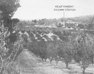
Photograph, View of what was Heathmont township taken from about Royal Avenue looking at Mr. Herman Pump's orchard. Old bridge over Canterbury Road can be seen on left
Typed below photograph, "View of what was Heathmont township taken from about Royal Avenue looking at Mr. Herman Pump's orchard. Old bridge over Canterbury Road can be seen on left." -
 Ringwood and District Historical Society
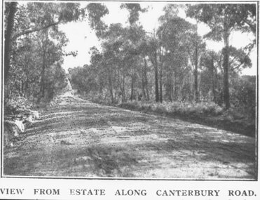
Photograph, Coleman's Heathmont Estate Sale, 15/12/1923. Looking west along Canterbury Road Heathmont. Railway bridge is situated at foot of hill
Printing below photograph reads, "View from estate along Canterbury Road." Typed on backing sheet below, "Canterbury Rd. Heathmont looking towards city. Railway bridge at foot of hill 1923. Area in foreground now shopping centre both sides of road." -
 Ringwood and District Historical Society
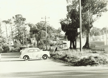
Photograph, Two photos taken at Deep Creek Road bridge c.1973
Typed below photograph, "Deep Creek Road bridge..."