Showing 213 items
matching warrandyte south
-
 Ringwood and District Historical Society
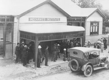
Photograph, Maroondah Highway Central, Ringwood. Mechanics Institute, Melbourne Street entrance - September, 1909
Black and white photograph (3 copies- 1 original and 2 copies)Typed below Photograph: "Mechanics Institute - Melbourne St. South. (Now demolished) Image shows a wooden building with sign above veranda reading "Mechanics Institute". Groups of men and children standing outside with car parked on roadway in front of building. Official opening by Premier of Victoria, Mr. John Murray. -
 Ringwood and District Historical Society
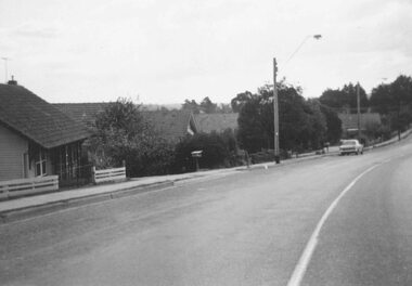
Photograph, South side of Bedford Road, Ringwood East, taken from outside shops on the corner of Illoura Avenue - 1/9/1974
Written on back of photograph, "Bedford Rd. looking at south side towards east from outside shops cnr. Illoura Ave. (As in brochure)" -
 Ringwood and District Historical Society
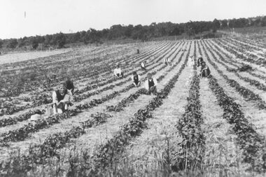
Photograph, Murphet's strawberry patch - New St. Ringwood - 1920
Black and white photograph. (2Copies)Written on back of photo, "Murfet's strawberry field. South side Rly line at Madden St. J. Maggs on left." -
 Ringwood and District Historical Society
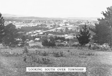
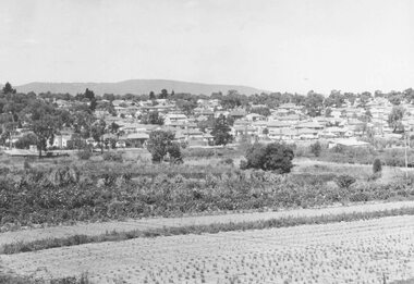
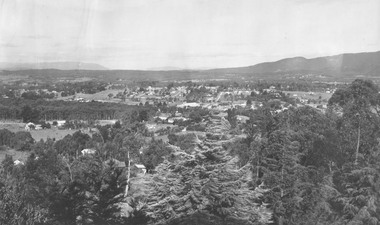
Photograph, Looking south over Ringwood township from Loughnans Hill c1930. Ringwood Street is the main road in the centre
Black and white photograph taken from hill overlooking township of Ringwood. (3 copies)Printed on photograph, "Looking south over township". Typed below photograph, "View from Loughnans Hill c1930. Ringwood Street is the main road in the centre. Old St. Pauls, railway crossing, Methodist church, state school, coolstores, etc. can all be seen". -
 Ringwood and District Historical Society
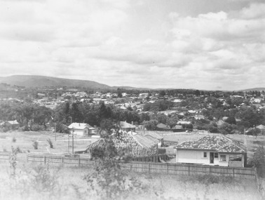
Photograph, New housing developments, New Street, 1960 viewed from railway line near Madden Street looking south-east
Written on back of photograph, "New housing settlement New Street, 1960. From railway line near Madden Street looking south-east. Dam centre foreground". -
 Ringwood and District Historical Society
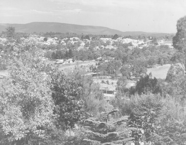
Photograph, View from Loughnan's Hill looking south east - c.1946
View from Loughnan's Hill looking south east - 1946. Written on back of photograph, "Smoke on left from Bamford's Timber Yard". -
 Ringwood and District Historical Society
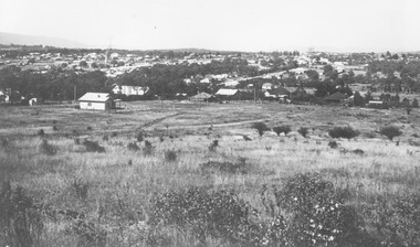
Photograph, View from Loughnan Rd. looking south east over Harrison Street/Andrew Street corner, c.1949
Black and white photograph showing some vacant land and new houses under construction. Developed area in background. (3 copies)Typed below photograph, "View from Loughnan Rd. looking south east, 1949". Written on backing sheet, "View from Loughnan Rd. to corner Harrison and Andrew Street, c1949". -
 Ringwood and District Historical Society
Photograph, Ringwood from Loughnan's Rd. - looking south, 1946
Black and white photograph, trees in foreground looking towards settled area. (3 copies).Various landmarks are noted on the backing sheet. They are, "Clock Tower, old Methodist Church, old Town Hall and old St. Paul's C of E spire". -
 Ringwood and District Historical Society
Photograph, Ringwood from Loughnans Hill. 1948
Black and white photograph taken from hill looking across valley towards settled area. Mountains in background. Catalogue card reads, "View from Loughnans Hill looking south east" -
 Ringwood and District Historical Society
Photograph, Looking south from railway line near Madden Street Ringwood (on right). 1960
Typed below photograph, "Looking south from railway line near Madden St. (on right). 1960" -
 Ringwood and District Historical Society
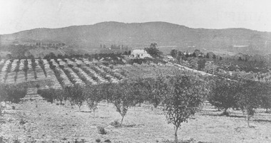
Photograph, View from Canterbury Road/Balfour Avenue area overlooking Martell's orchard, Heathmont, 1929
Black and white photograph of orchard. House in middle range, mountains in background. Photograph appears to be reproduced from subdivisional brochure. Note inserted in sleeve reads, "It has been pointed out that the mountains are to the east and the view is looking south. This therefore is not a 'straight' photograph. House still exists in Eden Avenue at October, 1996".(3 copies).Typed below photograph, "Panoramic view taken on the estate". "View overlooking Martell's orchard, Heathmont, 1929". Taken from corner Canterbury Rd. and Balfour Ave. looking south. Dandenong Creek just beyond house. Washusen Rd. on right". Written on back of one of the copies, "Heathmont Station Estate 1922". "Station Street, Lisgoold St. Canterbury Rd. Vivienne Cres. Balfour Ave." -
 Ringwood and District Historical Society
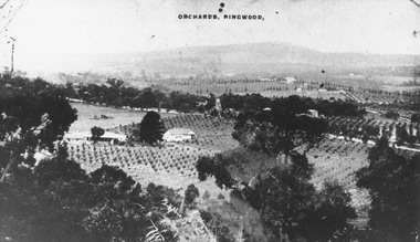
Photograph, View of Ringwood from Loughnans Hill. Pollards tank stand (centre) is on south side of Warrandyte Road. (Later location of Lauriston Crt.)
... (centre) is on south side of Warrandyte Road. (Later location of... tank stand (centre) is on south side of Warrandyte Road. (Later ...Black and white photograph looking down on orchards. House in centre of photograph, mountains in background. (3 copies)Written on back of one photograph, "Pollards tank stand" (centre) -
 Ringwood and District Historical Society
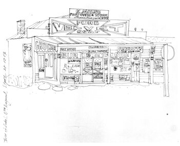
Photograph, Hand drawn picture by Eric Thake dated 1954 depicting Milne's Post Office and Store on the south-east corner of Oban Road and Warrandyte Road, North Ringwood
Typed below picture, "Mr. K. Milnes store. Corner Oban Rd. and Warrandyte Rd. 1954. Now demolished". -
 Ringwood and District Historical Society
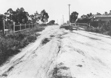
Photograph, Barkly Street, Ringwood - c1948
Black and white photograph of unmade road in poor condition. Houses in background.Typed below photograph, "Barkly St., Ringwood c.1948". Catalogue card states, "Taken about 100 yards down from Wantirna Road. Car probably going south along Wantirna Road. House far right now block of flats (Sept. 1975) but next two houses up street are there. Haig St. just behind car. Fence on house to left still there and curved front path. Shop visible corner Haig St. to left of big pole still there." -
 Ringwood and District Historical Society
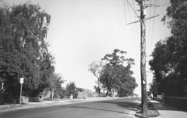
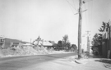
Photograph, Ringwood Street at Nelson Street Ringwood, looking south, early 1960s prior to Eastland development
Black and white photograph showing made road. Telegraph pole on right of picture. Tall trees to left of photograph. Houses either side of road. Road sign on telegraph pole reads, "Nelson St."Typed below photograph, "Ringwood St. looking south. Ringwood Reserve to left of row of trees in centre." -
 Ringwood and District Historical Society
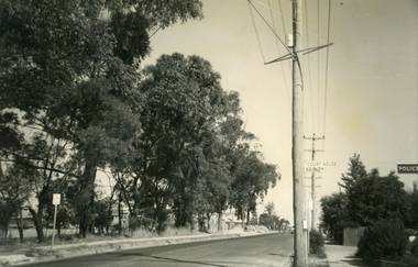
Photograph, Ringwood Street at Bourke Street Ringwood, looking south, early 1960s prior to Eastland development
Black and white photograph of road. Trees line left of street. Power pole to right of photograph with signage reading, 'Court House' and 'Bourke St.' Police station sign to right of picture.Typed below photograph, "Ringwood St. looking south. Ringwood Reserve on left". -
 Ringwood and District Historical Society
Photograph, Ringwood Street at Bond Street Ringwood, looking south, early 1960s prior to Eastland development
Typed below photograph, "Ringwood St. - The building of the Church of England and the vestry. Looking towards Civic Place. Eastland Car Park Civil Works on left". -
 Ringwood and District Historical Society
Photograph, Club Hotel, Ringwood from Whitehorse Road. Mt. Dandenong Road to old East Ringwood looking south. Taken about 1900-10
Catalogue card reads, "Club Hotel, Ringwood from Whitehorse Road. Mt. Dandenong Road to old East Ringwood looking south. Taken about 1900-10". Label below photograph is dated 1904. -
 Ringwood and District Historical Society
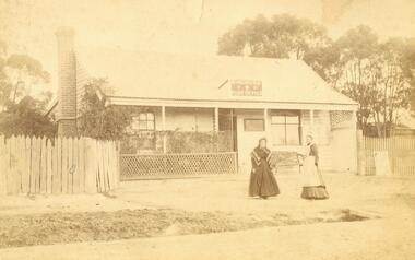
Photograph, Ringwood's first post office showing first postmistress, Miss M. Thompson. 1890
Typed below photograph, "Ringwood's first Post Office showing first Postmistress, Miss M. Thompson and her mother. 1890". (South side of Main Street (Maroondah Highway), approximately 300 meters west of Ringwood Railway Station). Writing on back of original photograph reads, "Grandma and Auntie Martha Thomson 1890". Stamps on back of photograph read, "Wall Bros. Photographers ... St. Kilda". Other stamp reads, "R.J.T. Futcher, Geelong, Victoria, Australia". -
 Ringwood and District Historical Society
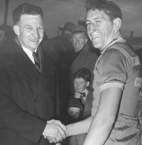
Photograph, Cr. A. Patterson (South Ward) congratulating winner of the Ringwood Road Race
Catalogue card reads, "Cr. A. Patterson (South Ward) congratulating winner of the Ringwood Road Race." [no date or identification of the winner]. -
 Ringwood and District Historical Society
Photograph, Parkwood High School from South-West 1981
Written on back of photograph, "E609, N19, 19/6/1981. Parkwood High School from South-West". -
 Ringwood and District Historical Society
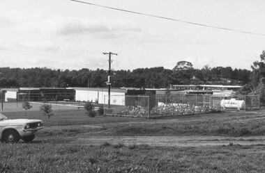
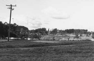
Photograph, The development east of Parkwood High School 1981
Written on back of photograph, "E610, N20, 19/6/1981. The development east of Parkwood High School which is to the left of the SEC pole. Roads in area close south of the school have not yet been made:. -
 Ringwood and District Historical Society
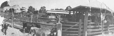
Photograph, Ringwood Market and Saleyards 1914
Black and white photograph (3 copies including original copy in poor condition)Typed below one photograph: "Ringwood Market and Saleyards. Now the site of the new Ringwood Market. Taken from Charter St. looking south east towards corner of Ringwood St. and Maroondah Highway. Old Coolstores in background on left were on Wantirna Rd. - 1914". Typed below another copy: "Ringwood Market - Corner Ringwood St. and Main St. - 1914". -
 Eltham District Historical Society Inc
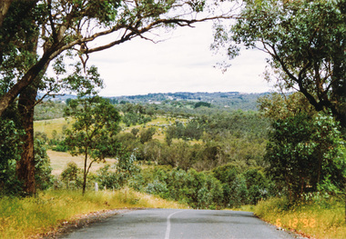
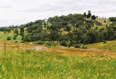
Photograph, Looking south along Menzies Road, Kangaroo Ground, 6 December 1992, 06/12/1992
The Eltham Horse Trail: Research and Warrandyte to Kinglake: Survey of proposed route, December 1992: (2) Warrandyte to Kangaroo GroundColour photographeltham horse trail (1992 survey), kangaroo ground, menzies road -
 Eltham District Historical Society Inc
Photograph, Looking south from Dawson Road, Kangaroo Ground, 6 December 1992, 06/12/1992
The Eltham Horse Trail: Research and Warrandyte to Kinglake: Survey of proposed route, December 1992: (2) Warrandyte to Kangaroo Ground, trail route to be determined (1992)Colour photographeltham horse trail (1992 survey), kangaroo ground, dawson road -
 Eltham District Historical Society Inc
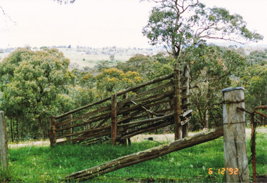
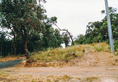
Photograph, Unopened section of Kings Road south from Glenvern Road, Panton Hill, 6 December 1992, 06/12/1992
The Eltham Horse Trail: Research and Warrandyte to Kinglake: Survey of proposed route, December 1992: (3) Kangaroo Ground to KinglakeColour photographeltham horse trail (1992 survey), glenvern road, kings road, panton hill -
 Eltham District Historical Society Inc
Photograph, Ingrams Road, south from Allendale Road, Research, 19 December 1992, 19/12/1992
The Eltham Horse Trail: Research and Warrandyte to Kinglake: Survey of proposed route, December 1992: (4) Connecting trail to ElthamColour photographeltham horse trail (1992 survey), allendale road, ingrams road, research (vic.) -
 Eltham District Historical Society Inc
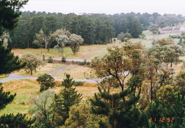
Photograph, Metropolitan Water pipe track south of Main Road from near The Esplanade, Research, 21 December 1992, 21/12/1992
The Eltham Horse Trail: Research and Warrandyte to Kinglake: Survey of proposed route, December 1992: (4) Connecting trail to ElthamColour photographeltham horse trail (1992 survey), research (vic.), the esplanade, main road -
 Eltham District Historical Society Inc
Photograph, Looking south-east at the intersection of Eltham-Yarra Glen Road and Kangaroo Ground-Warrandyte Road, Kangaroo Ground, 8 July 1994, 08/07/1994
Roll of 35mm colour negative film, 4 stripsFuji 100kangaroo ground, eltham-yarra glen road, kangaroo ground-warrandyte road -
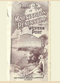 Ringwood and District Historical Society
Memorabilia, Tourist Map of Mornington Peninsula and Western Port - 1929
Multi-fold pictorial map of towns, railways and main roads east of Port Phillip Bay from Melbourne to Yarra Junction and south to Phillip Island and Wonthaggi, backed by details of main features and points of interest.Photo-Lithographed by Department of Lands and Survey, Melbourne, 2.8.1929.