Showing 1548 items matching " aerial photographs"
-
 Stawell Historical Society Inc
Photograph, North Western Woollen Mills -- Aerial View Showing Wood pile and train line at left
North Western Woollen Mills -Framed - Aerial ViewLarge Framed Photograph stawell industry -
 Stawell Historical Society Inc
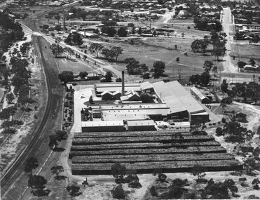
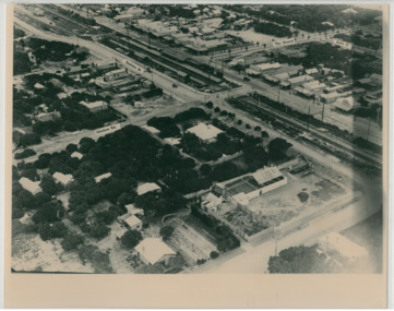
Photograph, Aerial Photo of Stawell 1981, 1981
Shows Railway Institute fire 1981. Swimming Pool in Cato Lake. Sawmill, King StreetVery Large Colour Print -
 National Vietnam Veterans Museum (NVVM)
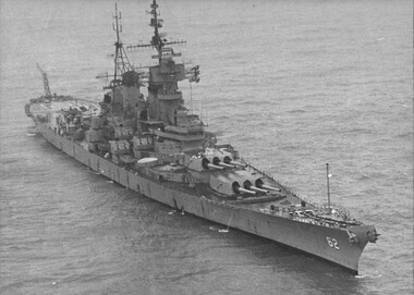
Photograph, Gibbons, Denis, USS New Jersey 1
Denis Gibbons (1937 – 2011) Trained with the Australian Army, before travelling to Vietnam in January 1966, Denis stayed with the 1st Australian Task Force in Nui Dat working as a photographer. For almost five years Gibbons toured with nine Australian infantry battalions, posting compelling war images from within many combat zones before being flown out in late November 1970 after sustaining injuries. The images held within the National Vietnam Veterans Museum make up the Gibbons Collection.A black and white photograph of the battleship USS New Jersey refurbished at a cost of US$27 million to engage targets, as far as thirty (30) miles inside North Vietnam. The New Jersey was recommisioned after President Nixon stopped the aerial bombing of the Northphotograph, tonkin gulf, president nixon, gibbons collection catalogue, uss new jersey, denis gibbons -
 Port Melbourne Historical & Preservation Society
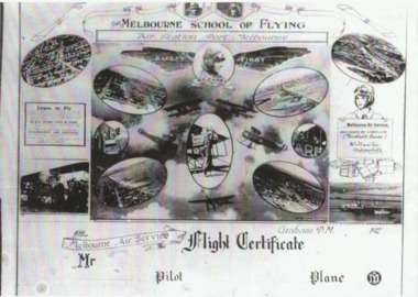
Photograph - Flight certificate given to passengers on Carey planes, 1920s
Sent by Carey's daughter Bertha Harvey during compilation of transport book "Linking "Us Together. (.01) lasercopy of aerial photo of Carey's Melbourne Air Service aerodrome on the Bend (Item .01 is absent from file as at Dec 2013) (.02) lasercopy of the Flight Certificate given to passengers on Carey planesfishermans bend, transport - aviation and aerodrome, r graham carey, melbourne air service -
 National Vietnam Veterans Museum (NVVM)
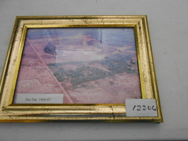
Photograph, Nui Dat 1966-67
... Nui Dat Photograph Coloured aerial copy of base Nui Dat ...Coloured aerial copy of base Nui Dat 1966-67.nui dat, photograph -
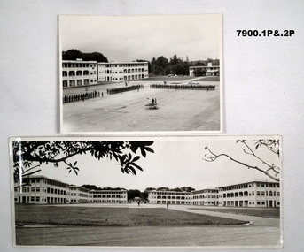 Bendigo Military Museum
Photograph - SELARANG BARRACKS, 1970
Various photos of Selarang Barracks in Singapore in 1970. Some aerial and some ground level views. Refer items in Collection of LLoyd Farrell. Refer Cat 7889P.1. Photo of 1 RAR on parade for Trooping of the Colours in 1970 at Selarang Base in Singapore. Covering 'A' 'B' 'C' and Admin Company. 2. Extended portrait photo of the Parade Square and buildings of Selarang Base, Singapore in 1970. 3. Aerial photo of Selarang Barracks from a distance. 4. Aerial photo of Selarang Barracks 1970. 5. Aerial photo of Changi Prison 1970 in Singapore.Written on back. 1. "1 M1+" 2. “Selarang Barracks 1970 occupied by 1st RAR” 4. “Selarang 70” 5. "Changi Prison 1970 Singapore".photograhs, changi, selarang, 1970, lloyd farrell. -
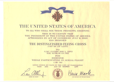 National Vietnam Veterans Museum (NVVM)
Document, United States of America, The Distinguished Flying Cross
On A4 gloss paper is the details from the United States of America of the Distinguished Flying Cross which was awarded to Flight Lieutenant Garry G. Cooper from Royal Australian Air Force for Heroism While Participating in Aerial Flight on the 6 May 1968. See photograph for more information on this award. The details are in black on a yellow background. There is a copy of a medal at the top of the document and it is signed by the Chief of Staff and Secretary of the Air Force. photocopy, flt lt g.g. cooper, garry cooper, 0219964, pilot, distinguished flying cross, australian force vietnam, raaf, united states of america, royal australian air force -
 Creswick Campus Historical Collection - University of Melbourne
Photograph - Aerial views of the Victorian School of Forestry Grounds and buildings, Victorian School of Forestry
... 1970s Photograph Aerial views of the Victorian School ...Three sets of Aerial views of the Victorian School of Forestry Grounds and buildings taken around the 1960s to early 1970s -
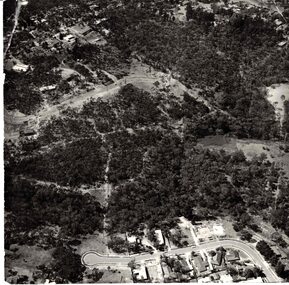 Whitehorse Historical Society Inc.
Photograph - Aerial Photograph, Bushland Yarran Dheran
... Aerial Photograph... Aerial Photograph ...Aerial photos of Yarra Dheran including Mitcham and Donvale.mitcham, donvale, yarra dheran -
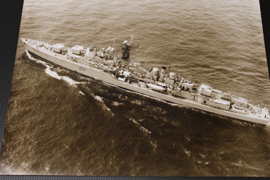 National Vietnam Veterans Museum (NVVM)
Photograph - Photograph, HMAS Vampire
During the Vietnam War, the HMAS Vampire repeatedly escorted the troop-carrier HMAS Sydney, which transported for Australian soldiers travelling to and from their service in Vietnam.An aerial b&w shot of HMAS Vampire at seaD11hmas, vampire, navy, vietnam, destroyer -
Moorabbin Air Museum
Photograph (item) - Essendon Aerodrome Aerial Derby Day 26 May 1927
... Photograph Essendon Aerodrome Aerial Derby Day 26 May 1927 ... -
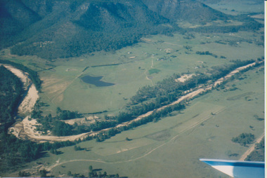 University of Melbourne, Burnley Campus Archives
Photograph - Colour print, Aerial View of Countryside, Unknown
... countryside aerial views river valley farm buildings dams ...4 colour photographs taken from a small aeroplane. Views of countryside, river, valley, mountains, dams, farm buildings countryside, aerial views, river, valley, farm buildings, dams, mountains -
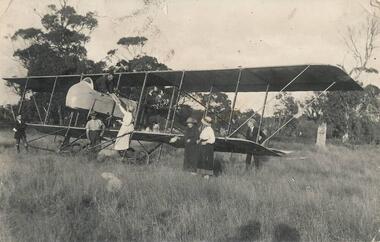 Phillip Island and District Historical Society Inc.
Photograph, 1920
Rhylston Park, an Italianate villa, was built in 1886 and the home of Mr Vaughan. One of a collection of over 400 photographs in an album commenced in 1960 and presented to the Phillip Island & Westernport Historical Society by the Shire of Phillip IslandPhotograph of an aeroplane and the first aerial bread delivery in Australia at Rhylston Park, Cowes, Phillip Island about 1920local history, photography, aeroplane, bread delivery, black & white photograph, air transport, john jenner, bryant west -
 Bendigo Military Museum
Photograph - 4th Field Survey Squadron – Operation MIZMAZE 92, Kimberley region, Western Australia, 1992
This is a set of 40 photographs taken in 1992 during 4th Field Survey Squadron’s deployment on Operation MIZMAZE 92 in the Kimberley region of Western Australia from the 13th of May to the 14th of July 1992. The area of operations was Wyndham, Halls Creek and Sandfire Flat. It was a two-part operation involving the field completion of topographic maps and the acquisition of mapping control by GPS field parties utilising Texas Instruments TI4100 Global Positioning System receivers. Survey parties conducted field checking of topographic maps and GPS control acquisition in Perentie 110 Series Survey variant FFR Land Rovers. Three Bell Kiowa LOH helicopters provided by 162 Recce Sqn supported field checking and limited deployment of GPS surveys parties. C-l30 Hercules from 36 Sqn supported deployment and extraction of personnel and equipment to and from from the AO. A Cessna 404 Titan Ambassador from Vee-H Aviation was used as the Wild RC10 camera platform for aerial photography acquisition.This is a set of 40 photographs taken in 1992 during 4th Field Survey Squadron’s deployment on Operation MIZMAZE 92 in the Kimberley region of Western Australia. The colour photographs are on 35mm negative film and are part of the Army Survey Regiment’s Collection. The photographs were scanned at 96 dpi. .1) - Photo, colour, 1992. CAPT Craig Hersant. .2) - Photo, colour, 1992. Unidentified officer/soldier. .3) & .4) - Photo, colour, 1992. Aboriginal rock art - Wandjina Gunduran, Donkey Creek. .5) - Photo, colour, 1992. Aboriginal rock art - Track Wandjinas, Donkey Creek. .6) & .7) - Photo, colour, 1992. CAPT Craig Hersant. .8) - Photo, colour, 1992. Kimberley region topography. CPL Glen Weatherell. .9) - Photo, colour, 1992. Unidentified personnel .10) - Photo, colour, 1992. Supermarket at unknown location. .11) to .13) - Photo, colour, 1992. Caravan park at unknown location. .14) - Photo, colour, 1992. Old bridge at Fitzroy Crosssing. .15) & .16) - Photo, colour, 1992. Survey party in Perentie 110 Series Land Rover. .17) & .18) - Photo, colour, 1992. Kimberley region topography. .19) - Photo, colour, 1992. Kimberley region topography. CPL Glen Weatherell. .20) - Photo, colour, 1992. Kimberley region topography, possibly the Bungle Bungles. .21) - Photo, colour, 1992. Kimberley region topography. SGT Frank Downie. .22) - Photo, colour, 1992. Kimberley region topography: the Bungle Bungles. .23) - Photo, colour, 1992. Kimberley region topography: the Bungle Bungles. .24) - Photo, colour, 1992. Kimberley region topography: the Bungle Bungles. SPR Neil Pedler. .25) & .26) - Photo, colour, 1992. Kimberley region topography: the Bungle Bungles. .27) - Photo, colour, 1992. Kimberley region topography. .28) - Photo, colour, 1992. Survey party with Perentie 110 Series Land Rover. .29) - Photo, colour, 1992. Kimberley region topography. .30) - Photo, colour, 1992. Survey party outside Perentie 110 Series Land Rover. .31) & .32) - Photo, colour, 1992. Survey party operating TI4100 GPS Receiver next to Perentie 110 Series Land Rover. SGT Eddie Jacobs. .33) & .34) - Photo, colour, 1992. Survey party operating TI4100 GPS Receiver next to Perentie 110 Series Land Rover. Unidentified surveyor. .35) - Photo, colour, 1992. Kimberley region topography. Hand water pump at well. .36) - Photo, colour, 1992. Survey party in Perentie 110 Series Land Rover. .37) - Photo, colour, 1992. Kimberley region topography. CPL Glen Weatherell. .38) - Photo, colour, 1992. Kimberley region topography viewed from Bell Kiowa LOH helicopter. .39) & .40) - Photo, colour, 1992. Unidentified surveyor field checking a preliminary map in a Bell Kiowa LOH helicopter..1P to .40P – There are no personnel identified. ‘1992 OP MIZMAZE annotated on negative sleeve.royal australian survey corps, rasvy, 4 fd svy sqn, op mizmaze 92 -
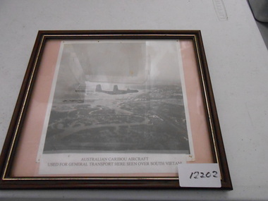 National Vietnam Veterans Museum (NVVM)
Photograph, Two RAAF Caribou over Vietnam
A black and white aerial photo of two Australian Caribou's aircrafts. The aircrafts were used in Vietnam for the transportation of soldiers to and from the conflict and was used for general transport of equipment. Photograph of two RAAF Caribou Aircraft over Vietnamcaribou, photograph, south vietnam -
 Bendigo Historical Society Inc.
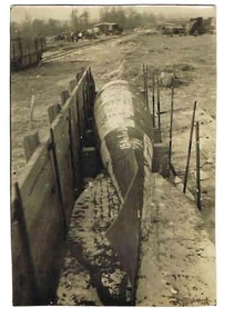
Photograph - ROBERT DENIS KELLY COLLECTION: TORPEDO
Black and white photo: torpedo situated on ground with wooden wall on LH side. Written on back in pencil 'Peronne, a Fritz aerial torpedo, 15 ft. long, 18 inches diameter, 1 1/4 tons in weight'person, robert denis kelly, world war 1, france, torpedo. -
Stawell Historical Society Inc
Photograph, B/W Aerial Photograph of Pleasant Creek Training Centre & Stawell Woolen Mills C 1960's, 1960's
... B/W Aerial Photograph of Pleasant Creek Training Centre... backing board. B/W Aerial Photograph of Pleasant Creek Training ...A3 Sized Aerial Photo on blue backing board.education, manufacturing -
 Bendigo Historical Society Inc.
Photograph - Kangaroo Flat Gold Mine Collection: photo album 1998
Photo album, black cover, gold border. One hundred colour photos, some with annotations. Label on front of album: Portal, machinery, underground shots 1998; drilling in Deborah St.; mines rescue vehicle; various staff; E.E.S. Displays; Board Meeting 1998. Staff photos: Rob Charlton, pump at Red, White Blue Cons.; Andrew Breen Workshop Manager; John Cahill; Patrick O'Boyle Mine Rescue Vehicle; John Cahill; Ben Clayton; Ricky Hannah; April Westcott; Ivette Maggs site clerk McMahons; Wayne Woodward; Fiona Hunt; Steve Woodall.kangaroo flat gold mine, bendigo mining nl, new bendigo gold project, goldmining, personnel, doug buerger, colin burns, tarnagulla, new moon, displays, box cut, unity mining, aerial photos, 1998 -
 Bendigo Historical Society Inc.
Photograph - Kangaroo Flat Gold Mine Collection: photo album 1998
Photo album, red cover with black binding. Seventy colour photos, some with annotations. Label on front of album: 'Office Move 1998. Bendigo Show, E.E.S. Display, 'Board' on site 1998, Residents visit Tarnagulla, shaft shots, E.E.S Display Central Deborah, Drilling at New Moon, Box Cut (2), Aerial site photos Nov. 1998' Album includes mine personnel photos of Doug Berger, Geoff McDermott, John Cahill, Colin Burns, Ken Belfrage, Dean Turnbull, Courtney Chamberlain, 'The Boys' - Frank, Woody, Pratty and Jason, and Jason Bourke. Mining photos include: Carshalton site 24.7.98, drilling at New Moon and portal reef mining Tarnagulla 1998.kangaroo flat gold mine, bendigo mining nl, new bendigo gold project, goldmining, personnel, doug buerger, colin burns, tarnagulla, new moon, displays, box cut, unity mining, aerial photos -
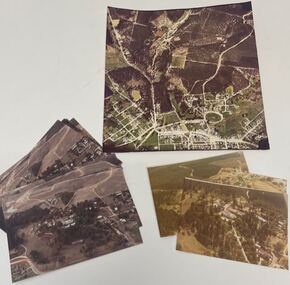
 Bendigo Historical Society Inc.
Map - FRED COWIE COLLECTION: AERIAL MAPS OF HEATHCOTE/EPPALOCK, 28-9-1960
Map, Heathcote C2, Township of Heathcote, Melbourne Road through town branching off to Bendigo & Echuca. Aerial Survey of Victoria. Photo-map prepared by Department of Crown Lands and Survey from photographs taken in 1960. Copied photographically at the Central Plan Office.Fred Cowie,46 McIvor Rd,Bgo..Central Plan Officemap, heathcote, fred cowie -
 Bendigo Historical Society Inc.
Map - FRED COWIE COLLECTION: AERIAL MAPS OF HEATHCOTE/EPPALOCK, 28-9-60
Map, Heathcote C3, Aerial Survey of Victoria, Photo-map prepared by Department of Crown Lands and Survey from photographs taken in 1960.Copied photographically at the Central Plan Office. Date 28-9 60, C.P.O.Neg. No.21588.Campaspe River, Coliban River. Flower Hill. Fred Cowie,46 McIvor Rd.Bendigo (Not located 29.9.2022)Central Plan Office.map, heathcote, fred cowie -
 Bendigo Historical Society Inc.
Map - FRED COWIE COLLECTION: AERIAL MAPS OF HEATHCOTE/EPPALOCK, 28-9-60
Map, Heathcote C4, Aerial Survey of Victoria,Photo-map prepared by Department of Crown Lands and Survey from photographs taken in 1960. Copied photographically at the Central Plan Office.Date 28-9-60,C.P.O.Neg.No.21590.Scale 4 inches to 1 mile. Fred Cowie,46 McIvor Rd,Bgo..Central Plan Office.map, heathcote, fred cowie -
 National Vietnam Veterans Museum (NVVM)
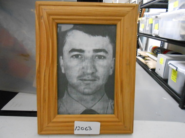
Photograph, Pilot Officer Robert Charles Carver (MIA)
Pilot Officer Robert Charles CARVER, 24was a career air force officer in No. 2 Squadron, RAAF. On 3 November 1970 the Canberra bomber he was in disappeared from a radar screen while returning from a night bombing mission in the northern I Corps Tactical Zone of South Vietnam. An extensive aerial search of the area failed to find any trace of the aircraft or crew and was called off after three days. In April 2009 the wreckage of the Canberra bomber was located in thick jungle in Quang Nam Province near the Laotian border. Human remains discovered near the site were identified in July 2009 as those of Carver and his crew and were repatriated to Australia on 31 August 2009 for burial in separate military funerals.Framed black and white head and shoulders photo of P.O. Carver (Missing In Action) in dress shirtphotograph, missing in action, p.o. robert carver, mia, no 2 squadron', canberra bomber, quang nam province, laotian border, royal australian air force, 0119223 -
 Chelsea & District Historical Society Inc
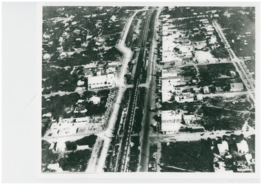
Photograph - Aerial Photo of Chelsea, c 1923
... Hansom was a pioneer of aerial photography in Australia. Chelsea ...Points of interest in the photo are Fox Theatre, Chelsea Railway Station and the building site of Masons Theatre on the corner of Chelsea Road and Station Street. Mr William Herbert Hansom was a pioneer of aerial photography in Australia.Black and white aerial photo of Chelsea, bordered by Thames Promenade, Balantyne Avenue, Catherine Avenue and Chelsea Road, Station Street, The Strand, Bath Street.W. H. Hansom ("Manders") Aerial Artist, Personally Conducted Flights over Melbourne and Suburbs St James' Building Bourke Street, Melbournechelsea, aerial photo, station street, chelsea road, the strand, bath street, fox theatre, masons theatre, w. h. hansom, chelsea railway station -
 Chelsea & District Historical Society Inc
Photograph - Aerial Photo of Chelsea, c 1923
... . Photograph Aerial Photo of Chelsea ...Points of interest in the photo are Fox Theatre in Station Street and Masons Theatre on the corner of Chelsea Road and Station Street; Chelsea Railway Station with a goods train going past. Street in photo are Station Street, Chelsea Road, Nepean Highway, Thames Promenade, Bath Street and The Strand. Black and white aerial photo of Chelsea. chelsea, aerial photo, station street, chelsea road, the strand, bath street, fox theatre, masons theatre, chelsea railway station, thames promenade, nepean highway -
 Chelsea & District Historical Society Inc
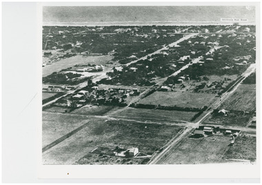
Photograph - Aerial Photo of Edithvale
... . The Edithvale Boat Shed can be seen on the foreshore. Photograph Aerial ...Edithvale Boat house was opened in 1918. Black and white aerial photo of Edithvale. It shows open paddocks, houses, unmade roads. The Edithvale Boat Shed can be seen on the foreshore. chelsea, aerial photo, edithvale boat house, edithvale -
 Whitehorse Historical Society Inc.
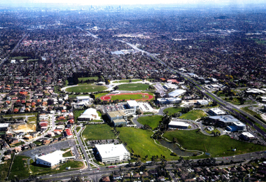
Photograph - Aerial Photograph, Tally Ho Industrial Park East Burwod, C.1995
... Aerial Photograph... Burwod Photograph Aerial Photograph ...Aerial Photo of Tally Ho Industrial Park. East Burwood Reserve and the Bill Sewart Athletic Track is in centre.tally ho industrial park, lend lease development pty ltd, east burwood reserve, bill sewart athletic track -
Clunes Museum
Photograph
Aerial coloured photo of Clunes, main buildings named and marked with yellow stickers, mines marked with white stickersaerial, clunes mines, john woodland collection -
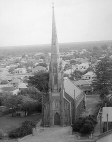 Stawell Historical Society Inc
Photograph, St. Matthew’s Presbyterian Church from town hall clock tower c1959-1960
St. Matthew’s Church 1959-1960 taken from town hall clock tower. Photo taken around 1959 -1960. The Centenary book states brick fence and pillars were a gift from McCracken Family, but not in the year the church was built. This photo was used for the Centenary book cover and was taken from the Town Hall clock tower. The roof line in bottom right corner of photo is rear of town hall.Two photographs of St Matthew's Church taken from the Stawell Town Hall. The photo shows an aerial view of the church and houses behind the church. stawell religion -
 Whitehorse Historical Society Inc.
Photograph - Ariel Photograph, Tally Ho Office Park 1995, 1995
Aerial view of Tally Ho Office Park on corner of Springvale Road & Burwood Highway, East Burwood. Site partly developed. Shows East Burwood Reserve (part) and Bill Sewart Athletics Track. Photo taken facing Burwood Highway.lend lease development pty ltd, tally ho office park, springvale road burwood east, burwood highway burwood east, bill sewart athletic track