Showing 2404 items
matching orchards
-
 Whitehorse Historical Society Inc.
Literary work, The Wattles, 2020
This account of "The Wattles" during the 1950's and 1960's has been based on memories of the 3 Stevens girls, Jennifer, Glenda and Dianne14 pages and 19.5 x 7 notenon-fictionThis account of "The Wattles" during the 1950's and 1960's has been based on memories of the 3 Stevens girls, Jennifer, Glenda and Dianneblue moon fruit cooperative ltd, mount pleasant methodist church, schwerkolt cottage & museum complex, stevens family -
 Eltham District Historical Society Inc
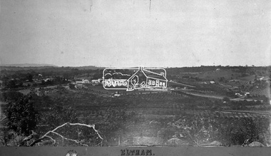
Negative - Photograph, Eltham, Vic, c.1890
... Orchards ...View looking northeast from present day Ely Street (near intersection of present day Cronus Court and Porter Street) across what will become the site of Eltham High School towards Main Road showing the Eltham Courthouse and Police station. View is very similar to the sketch of Eltham published in 'The Illustrated Australasian News', December 26, 1884, p212. Note the large bluestone cell block behind police house and stable. George Knapman's Shoeing Forge next to the courthouse and the concentration of buildings around the Evelyn Hotel and Watson's Eltham Hotel on opposite sides of Main Road at Pitt street. Also note George Stebbing's cottage (c.1860) on Pitt Street behind the courthouse and 'Sunnyside' (home of W.J. Taylor built c.1885) at the top of the hill on Bible Street. In the foreground are orchards running up to the main street, Maria Street and also between Brougham Street and Dalton Street bordered by Bible Street.This photo forms part of a collection of photographs gathered by the Shire of Eltham for their centenary project book,"Pioneers and Painters: 100 years of the Shire of Eltham" by Alan Marshall (1971). The collection of over 500 images is held in partnership between Eltham District Historical Society and Yarra Plenty Regional Library (Eltham Library) and is now formally known as the 'The Shire of Eltham Pioneers Photograph Collection.' It is significant in being the first community sourced collection representing the places and people of the Shire's first one hundred years.Digital image 4 x 5 inch B&W Negshire of eltham pioneers photograph collection, eltham, 1890, bible street, brougham steet, dalton street, eltham courthouse, eltham hotel, evelyn hotel, franklin street, grant house, knapmans forge, main road, maria street, orchards, police residence, police station, pre 1900, stebbing cottage, sunnyside, w.b. andrew corn store, watsons hotel, little eltham -
 Ringwood and District Historical Society
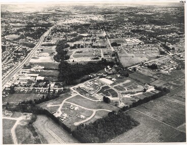
Photograph, Aerial View of Ringwood, Victoria - circa 1970
Black & white west-facing view over Oban Road along Mullum Mullum Road and Creek. Foreground showing early subdivision development of "Dunn's Orchard Estate" with formation of Frederic Drive (named after the orchardist - Frederic Dunn), Baron Court, Towerhill Drive, Tyson Court, Adele Court, Marilyn Crescent, Abbey Court, Highland Boulevard, Ailsa Court. -
 Ringwood and District Historical Society
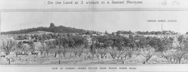
Photograph, Image used for land auction promotion of Garden Homes Estate between Mullum Mullum Road, Ringwood and Mullum Mullum Creek - 20/10/1923 , later developed to include The Centreway, Wattle Crescent, and Reserve Crescent, Ringwood
Black and white photograph of picture from subdivisional brochure. Picture shows orchard in foreground with a hill towards background. Treed area in the middle with a few houses scattered amongst them. To right of picture is printed, "Garden Homes Estate" with an arrow pointing to land. Printed above picture, "On the Land at 3 o'clock in a Seated Marquee. Typed below picture, "View of Gard -
 Ringwood and District Historical Society
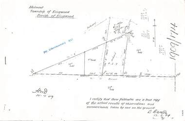
Document - Copy of Lands Department Field Notes - Parish of Ringwood, Victoria, Field Notes 1909/174 - Part of O.P. R72D surveyed 12.3.1909
Foolscap size photocopy of survey map with handwritten notations. References include Mount Dandenong Road, pathway, 2 room house, scillion, shed, WC, 17C sold, Cr lands, orchard, 17E sold, Township boundary, I certify that these field notes are a true copy of the actual results of observations and measurements taken by me on the ground (signed) D. Barker 12.3.09. -
 University of Melbourne, Burnley Campus Archives
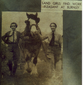
Photograph - Colour print, The Argus, Land Girls Find Work Pleasant at Burnley, 1937-1990
Photograph probably 1937, taken by A.P. Winzenried as a possible illustration for,"Green Grows Our Garden." Colour photograph. Copy of a newspaper article in, "The Argus," probably 1937, taken by A.P. Winzenried. Caption reads," Land Girls Find Work Pleasant at Burnley. Farm work appears to be a pleasant task for these girls photographed yesterday at Burnley Horticultural College. The plough horse is being returned to the stable after a day's work in the orchard." 2 girls leading Don, the draughthorse.Handwritten underneath, "M. Atkins, Don, J. Wakeford."a.p. winzenried, green grows our garden, female students, orchard, m. atkins, don, j. wakeford, donald, horse, land girls, students working outside, draughthorse, newspaper cutting -
 Southern Sherbrooke Historical Society Inc.
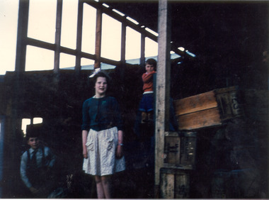
Photograph - Photo-colour- children at Narre Warren
Colour Photograph of children (maybe the Montague children), at the sheds of the orchard in Narre Warren. Features a boy(?) in blue on left hand side of the frame, a girl in a light dress and dark blue top with a ribbon in her hair in the centre, and a small boy in orange standing above her on the right. A crate can be seen on the far right side of the frame. See also VSSHP0195.01. -
 University of Melbourne, Burnley Campus Archives
Plan, Burnley Gardens. City of Richmond. Parish of Jika Jika - County of Bourke, 1927
Part-coloured plan showing drainage, sewerage drains, taps and waterstops. Area bounded by Swan St. To N, Yarra River on E and Richmond Park on SW side. Contour lines of orchard depicted, laying pens and yards. Coloured area depicts pavilion with surrounding garden and paths layout pencilled in. Photo-Lithograph by Dept. of Lands & Survey, Melbourne by W. Butsonsewerage, drainage, lithograph, pavilion -
 University of Melbourne, Burnley Campus Archives
Book - Register, The Orchard at Burnley Gardens, 22.05.1955
No. 237 handwritten. No. 01310H Norman Bros. Pty. Ltd. 60-62 Elizabeth St., Melbourneorchard, field station, history, fruit tree blocks, planting plans, newspaper cutting, red delicious apple, preston prolific fig -
 Linton and District Historical Society Inc
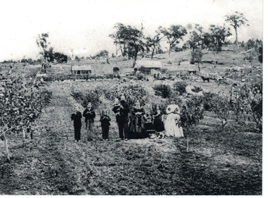
Photograph, The Wise Family at Their Property at Linton, circa 1869, 1869
Family members in this photograph are identified in the book "Dare to be Wise" - L-R: Thomas Wise, born 1858; William Bell Wise, born 1857; John Mardling Wise, born 1860; Thomas Mardling Wise holding baby Joseph James Jonah Wise, born 1868; Mary Bell Wise; Emily Rosina Wise, born 1866; Sarah Ann Wise, born 1854. The girl standing second from right is not identified but is probably Mary Wise, born 1859.Image shows the layout of what a small family holding in the second half of nineteenth century looked like. It also shows cultural and musical items important to the family along with their pets.Black and white copy of original photograph, which shows nine members of the Wise family standing in a row, at their property along Carngham Road at Linton. The photograph shows the layout of the property, with house and stables at rear, animals pens to one side, and orchard at the front. The three young boys in the photograph are holding flutes. The family's dog is lying down in front of the children to the right of the photo.wise family, houses, rural life, thomas mardling wise, mary wise (nee bell), sarah ann wise, william bell wise, thomas wise, mary wise, john mardling wise, joseph james jonah wise, emily wise -
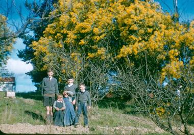
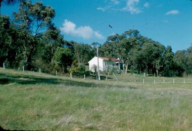
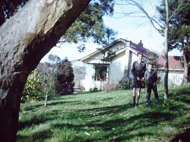
 Greensborough Historical Society
Photograph - Digital image, Frank Robinson, Greensborough wattles, 1954_
Greensborough wattles at Blackjack. The Blackjack property, house and acres of fruit orchards ran down to the Plenty River off Hume Street Greensborough and was the home of the Robinson family to late 1956. The photographs were taken as slides by Frank Robinson and digitised by his son James in 2015.Digital copy of colour photograph.robinson family -
 Greensborough Historical Society
Photograph - Digital Image, Blackjack - looking south east up the hill, 1954_
Greensborough wattles at Blackjack. The Blackjack property, house and acres of fruit orchards ran down to the Plenty River off Hume Street Greensborough and was the home of the Robinson family to late 1956. The photographs were taken as slides by Frank Robinson and digitised by his son James in 2015.Digital copy of colour photograph.robinson family, blackjack -
 University of Melbourne, Burnley Campus Archives
Photograph - Black and white print, Student Harvesting Activities, 1947-1948
Laminated photographs of students harvesting activitiesOn reverse, (1) "Carting in from Orchard." (2) "Grading for Cannery." (3) "Grading." (4) "Some 5 years old peach trees." (5) " 'Wardend' peach tree propagated by Burnley CRTS students 1947/8. 9ft ladder. Hanger pruning."orchard, grading, cannery, peach trees, burnley, crts, students, ladder, 1947-1948, commonwealth reconstruction scheme, hanger pruning, wardend peach -
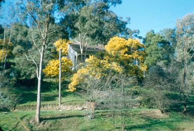
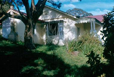
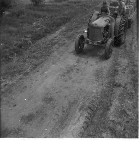
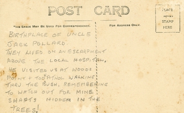 Ringwood and District Historical Society
Photographs, Collection of Pollard Photographs, Ringwood (Undated -probably early 1900's). Also Woods Point 1900, circa 1900
Pollard Photographs:; 1. Back of postcard of the Pollard home in Wonga Road (also called Anderson Creek Road Road, and now Warrandyte Road).; 2. One bushel net apples, J Pollard, Victoria, Australia.; 3. Joseph and Emma Pollard and Family. Emma is nursing baby Ethyl.; 4. Ringwood PS photograph. Jack Pollard is second from the RHS in the back row.; 5. Woods Point with arrow indicating mine manager's house: that of Joseph Pollard. Circa 1900. The Pollard family had a 20 acre orcharding property between Mullum Mullum Road and Wonga Road. Given on 4th September 2010 by Arthur Lunt from his cousin. The Pollard family. School photo at Ringwood State School. Jack�s father was Joseph � land (orchard) between Mullum and Wonga Roads +Additional Keywords: Pollard -
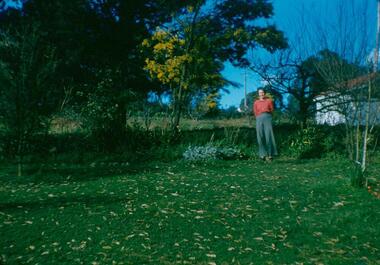
 Greensborough Historical Society
Photograph - Digital Image, Blackjack: five boys in the garden, wattle flowering, 1953_
Five boys in the garden at Blackjack, the home of the Robinson family to late 1956. The Blackjack property, house and acres of fruit orchards ran down to the Plenty River off Hume Street Greensborough. The photographs were taken as slides by Frank Robinson and digitised by his son James in 2015.Digital copy of colour photograph.blackjack, hume street greensborough, robinson family, frank robinson -
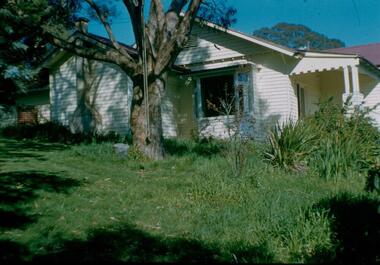
 Greensborough Historical Society
Photograph - Digital Image, Blackjack: Beb standing in the garden, 1953_
Beb standing in the garden at Blackjack, the home of the Robinson family to late 1956. The Blackjack property, house and acres of fruit orchards ran down to the Plenty River off Hume Street Greensborough. The photographs were taken as slides by Frank Robinson and digitised by his son James in 2015.Digital copy of colour photograph.robinson family, blackjack, hume street greensborough -
 Greensborough Historical Society
Photograph - Digital image, Frank Robinson, Greensborough Football Ground, 1956_
The Greensborough football ground 1956. The Blackjack property, house and acres of fruit orchards ran down to the Plenty River off Hume Street Greensborough and was the home of the Robinson family to late 1956. The photographs were taken as slides by Frank Robinson and digitised by his son James in 2015.Digital copy of colour photograph.frank robinson, greensborough football club -
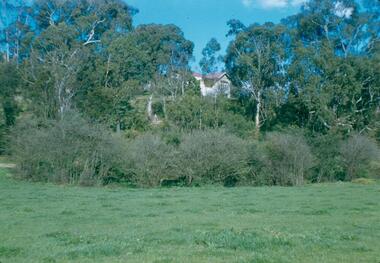
 Greensborough Historical Society
Photograph - Digital Image, Blackjack from the north west, 1954_
Blackjack from the north west. The Blackjack property, house and acres of fruit orchards ran down to the Plenty River off Hume Street Greensborough and was the home of the Robinson family to late 1956. The photographs were taken as slides by Frank Robinson and digitised by his son James in 2015.Digital copy of colour photograph.blackjack, robinson family -
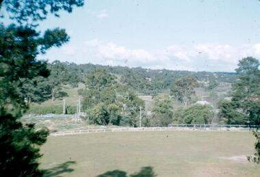
 Greensborough Historical Society
Photograph - Digital Image, View of Greensborough near Blackjack, 1954_
View of Greensborough near Blackjack. The Blackjack property, house and acres of fruit orchards ran down to the Plenty River off Hume Street Greensborough and was the home of the Robinson family to late 1956. The photographs were taken as slides by Frank Robinson and digitised by his son James in 2015.Digital copy of colour photograph.robinson family, blackjack -
 Greensborough Historical Society
Photograph - Digital Image, View of Blackjack near Greensborough, 1954_
View of Blackjack near Greensborough. The Blackjack property, house and acres of fruit orchards ran down to the Plenty River off Hume Street Greensborough and was the home of the Robinson family to late 1956. The photographs were taken as slides by Frank Robinson and digitised by his son James in 2015.Digital copy of colour photograph.robinson family, blackjack -
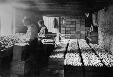 Eltham District Historical Society Inc
Photograph, Packing apples at Hurstbridge
Labourers grading and wrapping apples in paper and packing into wooden cases at the Hurstbridge packing shed. W.G. Gray's Allwood Nurseries was the largest orchard in the district and exported domestically and internationally. At one time the Hurstbridge railway station held the record for the number of apples sent away in one season. This photo forms part of a collection of photographs gathered by the Shire of Eltham for their centenary project book, "Pioneers and Painters: 100 years of the Shire of Eltham" by Alan Marshall (1971). The collection of over 500 images is held in partnership between Eltham District Historical Society and Yarra Plenty Regional Library (Eltham Library) and is now formally known as 'The Shire of Eltham Pioneers Photograph Collection.' It is significant in being the first community sourced collection representing the places and people of the Shire's first one hundred years.Digital imagesepp, shire of eltham pioneers photograph collection, hurstbridge, packing apples, fruit industry, export, apple industry -
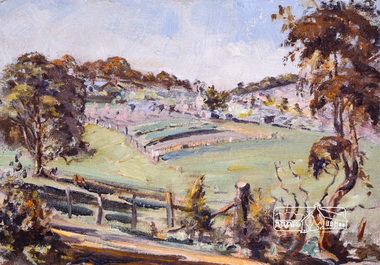 Eltham District Historical Society Inc
Photograph, Bird family Orchard, Pitt Street, Eltham, c.1980s
View looking northeast from near junction of Wattle Grove and Mount Pleasant Road across to Eucalyptus Road on right and Pitt Street at top. Early pioneer, George Bird Snr. arrived from England in 1852 and lived with his uncle, George Stebbing. He worked for him as bricklayer's assistant in building, among others, the Anglican and Methodist Churches in Eltham. In 1862 he purchased land in the east end of Pitt Street bounded by Eucalyptus Road and Wattle Grove and established a mixed farm and orchard. His son, Arthur Bird succeeded him and also worked on this orchard which then passed to Arthur's son, Harold Bird OAM, where Harold and Yvonne Bird lived in the family home till the mid 2000s A4 size photographic print reproduction of a paintingaos6, wattle grove, pitt street, arthur bird, bird family orchard, eucalyptus road, george bird, harold bird, yvonne bird, eltham -
 Eltham District Historical Society Inc
Photograph, Bird family Orchard, Pitt Street, Eltham, c.1980s, 1980s
View looking northeast from near junction of Wattle Grove and Mount Pleasant Road across to Eucalyptus Road on right and Pitt Street at top. Early pioneer, George Bird Snr. arrived from England in 1852 and lived with his uncle, George Stebbing. He worked for him as bricklayer's assistant in building, among others, the Anglican and Methodist Churches in Eltham. In 1862 he purchased land in the east end of Pitt Street bounded by Eucalyptus Road and Wattle Grove and established a mixed farm and orchard. His son, Arthur Bird succeeded him and also worked on this orchard which then passed to Arthur's son, Harold Bird OAM, where Harold and Yvonne Bird lived in the family home till the mid 2000s A4 size photographic printaos6, wattle grove, pitt street, arthur bird, bird family orchard, eucalyptus road, george bird, harold bird, yvonne bird, eltham -
 Greensborough Historical Society
Photograph - Digital Image, Blackjack: Peter and Paul, Greensborough 1956, 1956_
Peter and Paul Robinson, 1956, at Blackjack, the home of the Robinson family to late 1956. The Blackjack property, house and acres of fruit orchards ran down to the Plenty River off Hume Street Greensborough. The photographs were taken as slides by Frank Robinson and digitised by his son James in 2015.Digital copy of colour photograph.robinson family, blackjack -
 Greensborough Historical Society
Photograph - Digital Image, Blackjack from the river flats below, 1954_
Blackjack from the river flats below. The Blackjack property, house and acres of fruit orchards ran down to the Plenty River off Hume Street Greensborough and was the home of the Robinson family to late 1956. The photographs were taken as slides by Frank Robinson and digitised by his son James in 2015.Digital copy of colour photograph.blackjack, robinson family -
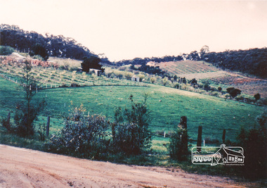
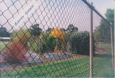
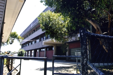 Whitehorse Historical Society Inc.
Photograph, Blackburn High School, 2012
Blackburn High School was opened in 1956. It was built on land previously covered with orchards owned by Mr Ron Pearce who was famous for growing cherries. In 1980 the school celebrated their silver jubilee. Blackburn High School has long been known for its successful music education program.Coloured photograph of recent Blackburn High School buildings on the corner of Springfield and William Road, Blackburn North - 2012blackburn high school, secondary schools, schools -
Whitehorse Historical Society Inc.
Legal record - Land Title, Spall Orchard, 1916-1982
Certificates of Title relating to the Spall Orchard, Wattle Valley Road Mitcham and surrounding parts of Crown Portion 128, Parish of Nunawading.Certificates of Title relating to the Spall Orchard, Wattle Valley Road Mitcham and surrounding parts of Crown Portion 128, Parish of Nunawading. Principal landowners: Louis Schwerkolt (Vol.3955 Fol.825), Francis Arnold Vaughan and James George & Sybil Margaret Spall (Vol.8249 Fol. 849). With historical summary, agent's sale notice 1984 and letter from Shirley Mill.Certificates of Title relating to the Spall Orchard, Wattle Valley Road Mitcham and surrounding parts of Crown Portion 128, Parish of Nunawading.wattle valley road, mitcham, highland avenue mitcham, trenham court mitcham, spall, james george, spall, sybil margaret, vaughan, francis arnold, schwerkolt, louis, mill, shirley, land titles -
 University of Melbourne, Burnley Campus Archives
Photograph - Colour prints, Garden Views, c2002
Collection of photographs donated by FOBG member Wendy Hansen. (1) Field Station looking through wire fence. (2) Wendy Hansen seated on bench beside Luffmann Ponds. (3, 4) Orchard Border. (5) Luffmann Ponds and resident heron. (6) Sunken Garden. (7) Rose Garden. (8, 9) Kath Deery Native Garden. (10) Sunken Garden.fobg, wendy hansen, field station, luffmann ponds, orchard border, sunken garden, rose garden, kath deery native garden -
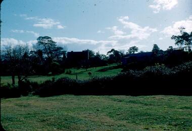
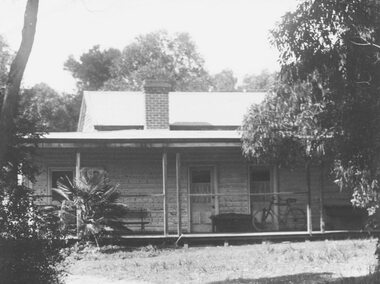 Ringwood and District Historical Society
Photograph, Original home on which Ringwood High School now stands, Bedford Road
Written on back of photographs, "This house is said to be the original home on which the High School, Bedford Road now stands. Owner of the orchard was Mrs. Theo Anderson, landscape painting artist. Original owner of land was ? Williams". Other copy says artist was, "Theodosia Anderson". -
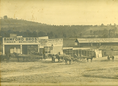 Ringwood and District Historical Society
Photograph, Maroondah Highway Central, Ringwood. Bamford's Timber Yard, 1910
Sepia photographImage shows timber yard with men and horse-drawn vehicle outside building. Warrandyte Road on right leading to Kennedy's orchard. Shop on corner was 'A. Wagner, Hairdresser. Photograph received from a Mr. Harrison, E.S.& A Bank Manager , Frankston. (Peter Paynes photographer).