Showing 174552 items
matching 34-schutt-street
-
 Eltham District Historical Society Inc
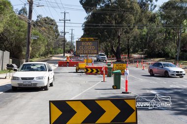
Photograph, Peter Pidgeon, Looking north at Walsh Street, Bolton Street upgrade, Eltham, 13 November, 2017, 13/11/2017
North bound lane closure. Born Digitalbolton street, bolton street upgrade, eltham, streets, walsh street -
 Eltham District Historical Society Inc
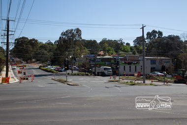
Photograph, Peter Pidgeon, Bolton Street Shops, Bolton Street upgrade, Eltham, 13 November, 2017, 13/11/2017
North bound lane closure. Born Digitalbolton street, bolton street upgrade, eltham, streets, walsh street, bolton street shops, bolton fish & chips, bolton pizza & pasta, bolton steet fruit market, bolton street deli, bolton street hot bread kitchen, chicken on charcoal @ bolton st, fleur de feliss florist, stephens meats, the cheesecake shop -
 Eltham District Historical Society Inc
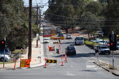
Photograph, Peter Pidgeon, Looking north across Main Road up Bolton Street, Eltham, during Bolton Street upgrade, Eltham, 13 November, 2017, 13/11/2017
North bound lane closure. Born Digitalbolton street, bolton street upgrade, eltham, streets, walsh street, bolton street shops, bolton fish & chips, bolton pizza & pasta, bolton steet fruit market, bolton street deli, bolton street hot bread kitchen, chicken on charcoal @ bolton st, fleur de feliss florist, stephens meats, the cheesecake shop, main road -
 Eltham District Historical Society Inc
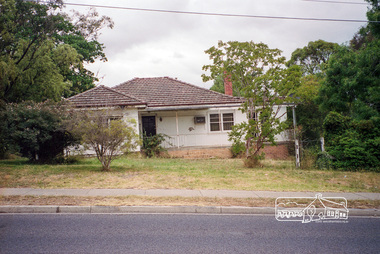
Photograph, Margaret Ball, 17 Bible Street, cnr with Brougham Street, Eltham, c.1999, 1999
The Margaret Ball (Pre 1960s Houses) Collection was a personal project initiated to mark the year 2000 and arose as a result of the disappearance of many pre-1960s parts of Eltham due to development. Approximately 200 pre-1960s style houses that were left in Eltham between Main Road and east to Bible Street, between Cecil Street to the north and south to Dalton Street were photographed in late 1999. Not all of the houses could be photographed; some because the garden or trees blocked the view of the house, others because of rubbish or cars were in the way, some because people were working on the house or in the gardens at the time.Roll of 35mm colour negative film, 6 stripsAgfa HDC 200 plus-2eltham, houses, streets, margaret ball (pre 1960s houses) collection, bible street, brougham street -
 Eltham District Historical Society Inc
Photograph, Margaret Ball, 74 Bridge Street, Eltham, Nov-Dec 1999 now part of units 72-74 Bridge Street, 1999
The Margaret Ball (Pre 1960s Houses) Collection was a personal project initiated to mark the year 2000 and arose as a result of the disappearance of many pre-1960s parts of Eltham due to development. Approximately 200 pre-1960s style houses that were left in Eltham between Main Road and east to Bible Street, between Cecil Street to the north and south to Dalton Street were photographed in late 1999. Not all of the houses could be photographed; some because the garden or trees blocked the view of the house, others because of rubbish or cars were in the way, some because people were working on the house or in the gardens at the time.Roll of 35mm colour negative film, 7 stripsKodak GC 400-6eltham, houses, streets, margaret ball (pre 1960s houses) collection, bridge street -
 Eltham District Historical Society Inc
Photograph, Margaret Ball, Looking towards Bible Street along Dudley Street, Eltham, June 1999, 1999
The Margaret Ball (Pre 1960s Houses) Collection was a personal project initiated to mark the year 2000 and arose as a result of the disappearance of many pre-1960s parts of Eltham due to development. Approximately 200 pre-1960s style houses that were left in Eltham between Main Road and east to Bible Street, between Cecil Street to the north and south to Dalton Street were photographed in late 1999. Not all of the houses could be photographed; some because the garden or trees blocked the view of the house, others because of rubbish or cars were in the way, some because people were working on the house or in the gardens at the time.Roll of 35mm colour negative film, 5 of 6 stripsFuji 200eltham, houses, streets, margaret ball (pre 1960s houses) collection, dudley street -
 Eltham District Historical Society Inc
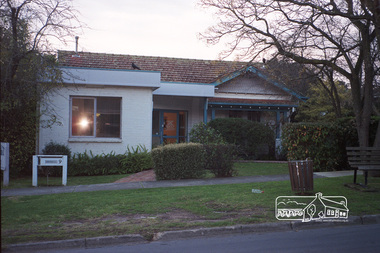
Photograph, Margaret Ball, Luck Street Clinic, 9 Luck Street, Eltham, June 1999, 1999
Owner 1960s: Dorothy Jolly, wife of Dr Jolly. Rented by Kenneth Johnson At time of photo the clinic was the practice of Dr Adams and Dr BowersThe Margaret Ball (Pre 1960s Houses) Collection was a personal project initiated to mark the year 2000 and arose as a result of the disappearance of many pre-1960s parts of Eltham due to development. Approximately 200 pre-1960s style houses that were left in Eltham between Main Road and east to Bible Street, between Cecil Street to the north and south to Dalton Street were photographed in late 1999. Not all of the houses could be photographed; some because the garden or trees blocked the view of the house, others because of rubbish or cars were in the way, some because people were working on the house or in the gardens at the time.Roll of 35mm colour negative film, 10 stripsFuji 200eltham, houses, streets, margaret ball (pre 1960s houses) collection, luck street -
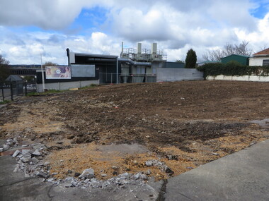
 Ballarat Heritage Services
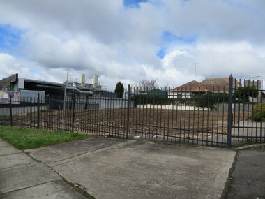
Photograph - Colour, Vacant Lot on the Corner of Armstrong Street South and Grant Street, Ballarat, 2017, 15/09/2017
Colour photograph of a vacant block. It had formerly been Leading Edge Computer which burnt down in 2016. The building was leveled in September 2017.armstrong street south, vacant black, grant street -
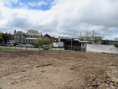
 Ballarat Heritage Services
Photograph - Colour, Vacant Lot on the Corner of Armstrong Street South and Grant Street, Ballarat, 2017, 15/09/2017
Colour photograph of a vacant block. It had formerly been Leading Edge Computer which burnt down in 2016. The building was leveled in September 2017.armstrong street south, ballarat -
 Ballarat Heritage Services
Photograph - Colour, Vacant Lot on the Corner of Armstrong Street South and Grant Street, Ballarat, 2017, 15/09/2017
Colour photograph of a vacant block. It had formerly been Leading Edge Computer which burnt down in 2016. The building was leveled in September 2017.lamp, anderson and ritchie -
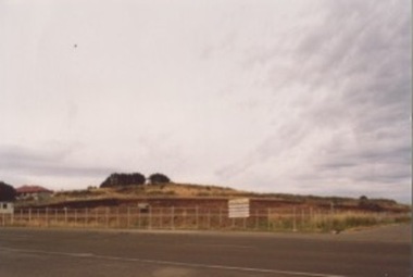
 Ballarat Heritage Services
Photograph - Photograph - Colour, Corner of Vickers Street and Albert Street, Sebastopol, 2020, 07/04/2020
The South Star Mine commenced operations in the 1880s and worke the quartz laods after the great floods of 1875 forced the closure of most alluvial mines. The South Star Mine sunk its first shaft in 1886, but broke into old alluvial workings and had to be abandoned because of flooding. The second shaft commenced in 1887, and was the deepest eer sunk in the Ballarat district, reaching 956 metres. 180 men worked three shifts each day.Colour photograph of the site of the South Star Mine in Sebastopol. sebastopol, albert street, south star mine, mining -
 Stawell Historical Society Inc
Photograph, Upper Main Street Stawell with the Patrick Street & Main Street corner at centre of Photo 1880
Stawell Township - Upper Main Street 1880. Patrick Street Main Street corner at centre of Photo.stawell -
 Northern District School of Nursing. Managed by Bendigo Historical Society Inc.
Photograph - Nursing staff outside "Mayfort"
The Northern District School of Nursing opened in 1950 in to address the issues around nurse recruitment, training and education that had previously been hospital based. The residential school was to provide theoretical and in-house education and practical training over three years. The students would also receive practical hands-on training in the wards of associated hospitals. The Northern District School of Nursing operated from Lister House, Rowan Street, Bendigo. It was the first independent school of nursing in Victoria and continued until it closed in 1989.Three (unnamed) nurses outside "Mayfort", Nurse's accommodation Wattle Street, Bwendigo, the NDSN school's first hostel, View Street. Colour photograph. Mayfort - nurse's accommodation for trainees during P.T.S. intakes.Mayfort, Wattle Streetndsn, nursing, uniforms -
 Kilmore Historical Society
Photograph, Sydney Street & Clarke Street
15cm x 10cm coloured photograph of the construction site on the corner of Sydney Street and Clarke Street. The site is now Coles Supermarket, Aldi, Liquorland, McDonalds, Coles Express, Kilmore Pizza Factory. Multiple photos taken over a period of time before the structure was being built. Brewery Hill can be seen in the backgroundWritten on the back: Site being prepared for the new Coles buildingconstruction, supermarkets -
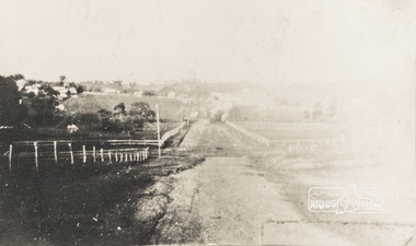 Eltham District Historical Society Inc
Photograph, Brougham Street, Eltham, early 1900s, 1900s
Colour photograph of a poor quality photograph (in album) of Brougham Street, Eltham looking east from near Susan Street, early 1900seltham, brougham street, wellington street, susan street -
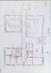 Federation University Historical Collection
Building Plan, School of Mines Lydiard Street Administration Building, Late 1970s
Office spaces in SMB, Lydiard Street Administration Building at street level. Each of the five photocopies shows a different arrangement of the Council Room.ballarat school of mines, administration building, plans, lydiard street, offices -
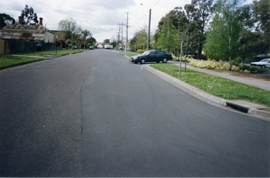 Whitehorse Historical Society Inc.
Photograph, Victoria Street, Mitcham, 1/10/2000 12:00:00 AM
Coloured photograph of of Victoria Street looking east. Car is exiting from multi storey car park in Edward Street into Victoria Avenue.victoria street, mitcham -
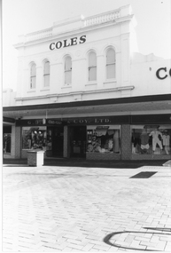 Stawell Historical Society Inc
Photograph, G. J. Coles Shop at 113 Main Street Stawell -- Different Angle
Shop 113 Main Street Stawell once Coles retail store now Lyal Eales. Coles store operated around 1984, 1991. Lyal Eales opened in 2013.A different view of the Coles retail store when the street was turned into a mall, as the photo shows a brick pavement in front of the building. The entrance area between two display windows with a third display windows to the right. The upper level has 5 arch shaped windows.COLESg. j. coles retail shop stawell -
 Surrey Hills Historical Society Collection
Photograph, 6a Thistle Street, Surrey Hills, 1924
One of the oldest homes in Surrey Hills. The photo was taken in 1924 when the property was purchased by Mr John Francis Evans, father of Mrs Lillian Austin. The Evans family came from Gembrook. John Evans was born in Wales; he and his wife Mary had 3 children, 2 daughters and one son. Mary Evans pre-deceased her husband, who died on 23 October 1924 at Hillsborough, 6A Thistle Street. The first owner of the property was Mrs Rachel Sweetnam (nee Lewis) who married Thomas Edward Sweetnam on 24 September 1884 at St John's Church, Camberwell. REF: THE ARGUS 4 Oct 1884 Thomas second eldest surviving son of Matthew Sweetnam married to Rachel (Ray) third eldest daughter of Captain T.D. Lewis, Culm Haven, Camberwell. Thomas was active in land sales and variously described as a land agent, real estate agent and auctioneer. The property - Hillsboro or Hillsborough - was originally a house on a farm of 10 acres owned by her. It became 6A Thistle Street. According to the Alan Holt property register Rachel Sweetnam owned the property prior to 1890 and a family tree on Ancestry.com has that it was owned by her in c1886. It is likely that at this stage the property was an investment rather than the Sweetnam's family residence. Other property owners or residents are: 1890 Selina Gaylor 1900 Stephen Pullen 1910 William Murray (draftsman) 1920 George C Hughes 1930 Arthur Leslie Austin (tram driver) 1980 Mrs Lillian Evelyn Austin Lillian Austin died on 19 August 1983 and the property was sold that year for $87,000. The house is still extant (January 2025). Note that we also have material / photos regarding George Hughes and family.Black and white photo of a timber home with brick chimneys and a (?) corrugated iron roof. There are sheds and outbuildings attached to the house. The garden looks untended. In the background a mature eucalypt tree can be seen.houses, hillsboro, timber houses, mrs lillian austin, hillsborough, selina gaylor, stephen pullen, william murray, george hughes, arthur austin, john francis evans, thistle street -
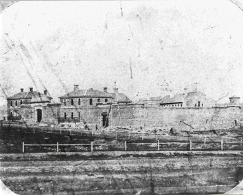 Federation University Historical Collection
Photograph - Photograph - Black and White, Former Ballarat Gaol, c1861, c1861
The former Ballarat Gaol was commenced in 1856 and completed in 1862, This view looks up Lydiard Street South, and was taken before the Ballarat Courthouse was built south of the gaol in 1868. The wall was built from quarried basalt with local bricks. A system of burning the lime mortar between the joints and the shape of the wall meant it had a high degree of stability. From 1870 on more buildings were constructed and these became the School of Mines and Industries Ballarat. The Gaol closed in 1965. This image shows the Ballarat Gaol c. 1861 giving us an understanding of what the site looked like before all the changes that have occurred over the years since the gaol closed and other organisations have had the site. Black and white image showing the former Ballarat Gaol from Lydiard Street South.Label on underneath photograph: The Ballarat Gaol, c.1861 - This view looks up Lydiard Street towards our present school entrance. The gaol buildings remain unchanged . Note that the Court House, now S.M.B's Elec. classrooms, has not yet been built on the right hand side of the gaol.ballarat gaol, ballarat school of mines, gaol, m113, lydiard street, courthouse, lime mortar, lydiard street south -
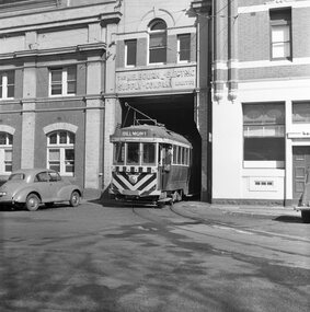 Ballarat Tramway Museum
Photograph - Black & White Photograph/s, John Webster, 21/08/1955 12:00:00 AM
Yields information about the appearance of one of Geelong's trams prior to closure and entry to the depot building.Black and white photograph of Geelong No. 34 leaving the depot with the conductor leaning out front door. The tram has the destination of "Belmont" Photographed by John Webster, 21/8/1955. The "Stripped Horror" Actual print part of the whole negative, see btm 4197i3.. Negative scanned at hi res 4/6/2020 and image updated.On rear in ink "Stripped Horror, / Tram 34, Geelong Vic" and in top right hand corner "EH 34 / 21-8-55 JR" On Negative in ink "EH36"tramways, trams, geelong, depot, tram 34 -
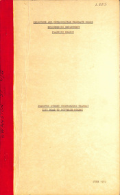 Melbourne Tram Museum
Document - Report, Melbourne & Metropolitan Tramways Board (MMTB), "Swanston Street Underground Tramway City Road to Bouverie Street", Jun. 1972
Report - Foolscap, card covers, red binding strip, 12 sheets + 4 drawings (fold out), titled "Swanston Street Underground Tramway City Road to Bouverie Street", detailing the proposal, including costs, issues, drains, obstructions. Includes cross sections of the tunnels and notes on public access. Dated June 1972. Drawings not scanned.Has "Lees" in ink on top right hand corner.trams, tramways, underground tramways, swanston st, reports, new tramways -
 Surrey Hills Historical Society Collection
Photograph, Pye and Stamford family members at 'Tanglewood', 12 Loch Street, Surrey Hills, c1916-1918, 1916-1918
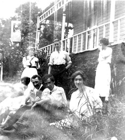
Both Hazel and Mabel Pye were artists and their father built a studio at the back of the 12 Loch Street home. The family were also associated with the amateur theatre group 'The Benwerrin Players'. Information from Frank Stamford (via Surrey Hills History Facebook page), March 2017: "This photograph was taken around 1918. It is a family occasion. The four people sitting down, from left to right, are Clara (Dolly) Stamford nee Noar (my grandmother), Frank Stamford (my grandfather), Laurence Stamford (my father, who was born in 1904), and Hazel Pye (a cousin of my father). The three people standing, from left to right, are Alice Pye (nee Noar) - mother of Mabel and Hazel, and sister of Clara, Reg Stamford (brother of Laurence, and born in 1900), and Mabel Pye." Dorothy Stamford was a cousin of Hazel and Mabel Pye.Black and white photo including Misses Mabel and Hazel Pye with other family members. The group is seated and standing in front of a verandah of a timber Edwardian style home.loch street, artists, 'tanglewood', mrs clara ellen stamford, miss clara ellen noar, frank stamford, laurence stamford, hazel pye, miss alice elanor noar, mrs alice eleanor pye, reg stamford, mabel pye -
 Federation University Historical Collection
Photograph - Black and White, Vernon Holt, Frank Wright at 6 Pleasant Street North, Ballarat, 1923, Jan 1923
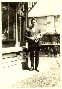
Frank Wright was a renown resident of Smeaton, where he was born. He lived at Laura Villa, and attended Smeaton State School. His father William was a gold miner and his mother's name was Sarah. Their family won many singing and instrumental awards. Frank was tutored by Percy Code and was awarded a gold medal for the highest marks in the ALCM examinations in the British Colonies at the age of seventeen years. He became the Australian Open Cornet Champion by the age of eighteen. A year later, Frank conducted the City of Ballarat Band, and later the Ballarat Soldiers’ Memorial Band. He formed the Frank Wright Frisco Band and Frank Wright and his Coliseum Orchestra. These bands won many South Street awards, and Frank as conductor won many awards in the Australian Band Championship contest. In 1933 Frank Wright sailed to England to conduct the famous St Hilda’s Band and was later appointed Musical Director of the London County Council, where he organized many amazing concerts in parks, in and around the London district. He was made Professor of Brass and Military Band Scoring and conducted at the Guildhall of Music and Drama. Frank was often invited to adjudicate Brass Band Championships around Europe, in Australia, including South Street and in New Zealand. The Frank Wright Medal at the Royal South Street competition is awarded to an individual recognized as making an outstanding contribution to brass music in Australia.Black and white photograph of a man standing standing on a path beside the wall and windows of a house. The man is dressed in a suit and is holding a cornet. The place is 6 Pleasant Street, North Ballarat and the man is Frank Wright.Written is pen on the back - Frank Wright 21, 6 Pleasant St N. Ballarat, Taken by Vernon Holt, Jan 1923frank wright, cornet, conductor, ballarat, vernon holt -
 Moorabbin Air Museum
Manual (Item) - Cessna - Operation Manual For Cessna 182 (Skylane)
Schutt Flying Academy Operations Manual Appendix 3 To Section 4 -
Moorabbin Air Museum
Manual (Item) - Cessna - Operation Manual For Cessna 210
Schutt Flying Academy Operations Manual Appendix 5 To Section 4 -
Moorabbin Air Museum
Manual (Item) - Cessna - Operation Manual For Cessna 172 (Skyhawk)
Schutt Flying Academy Operations Manual Appendix 2 To Section 4 -
Whitehorse Historical Society Inc.
Newspaper, Nunawading Gazettes 1976, 1976
A collection of 1976 Nunawading Gazettes Vol 26.A collection of 1976 Nunawading Gazettes Vol 26. The following numbers are missing: Nos, 2, 3, 5, 8, 11, 17, 25, 27, 28, 33, 34, 36, 47, 50A collection of 1976 Nunawading Gazettes Vol 26. nunawading gazette, newspapers -
 Bacchus Marsh & District Historical Society
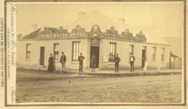
Photograph, Court House Hotel Main Street Bacchus Marsh 1883
This building on the corner of Court House Place and Main Street Bacchus Marsh was a licensed hotel since 1864. Prior to 1864 the building was in use as a saddlery business, established by Joseph Purday and Alfred Smith. In 1864, Purday and Alfred Tanner converted the shop to a hotel. Tanner, followed by his wife Ann, were licensees until 1892. The hotel signage above the door features the Prince of Wales feathers, an acknowledgement of the Prince of Wales Volunteer Light Horse Werribee unit which used the hotel for their meetings. In 1911 the single-storey hotel was demolished and a two-storey brick hotel was built. The identities of the five men and one woman in the photo are not known. The woman at the left of the group is possibly Ann Tanner who was the licensee around the time this photograph was taken. Small sepia unframed photograph on card with gold border framing photograph. Housed in the album, 'Photographs of Bacchus Marsh and District in 1883 by Stevenson and McNicoll'. A group of five men and one woman can be seen standing in front of the Court House Hotel building, Main Street Bacchus Marsh. A large ornate sign around the roofline bears the words “Courthouse Hotel”. Above the door a sign featuring the Prince of Wales feathers also has the name “Ann Tanner.” One of the men is displaying a document which apparently is of some importance, now lost.On the front: Stevenson & McNicoll. Photo. 108 Elizabeth St. Melbourne. COPIES CAN BE OBTAINED AT ANY TIME. On the back: LIGHT & TRUTH inscribed on a banner surmounted by a representation of the rising sun. Copies of this Portrait can be had at any time by sending the Name and Post Office Money Order or Stamps for the amount of order to STEVENSON & McNICOLL LATE BENSON & STEVENSON, Photographers. 108 Elizabeth Street, MELBOURNE. stevenson and mcnicoll 1883 photographs of bacchus marsh and district, hotels bacchus marsh, court house hotel bacchus marsh -
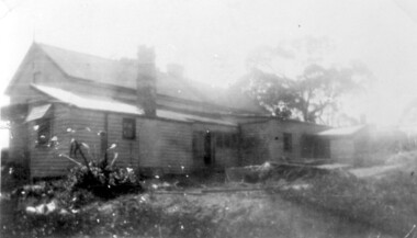
 Eltham District Historical Society Inc
Photograph, "Southern Wood", Brougham Street and Bolton Street, Eltham
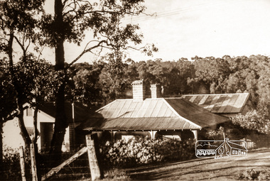
Sepia photograph showing 'Southern Wood' at cnr of Brougham and Bolton streets, Eltham. The Heidelberg School artist Walter Withers lived in this property.southern wood, brougham street, bolton street, eltham, walter withers