Showing 19889 items
matching east-malvern
-
 Ringwood and District Historical Society
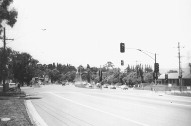
Photograph, Canterbury Road looking east from west side of Heatherdale Road intersection up towards Cadbury. Ringwood 1979
Written on back of photograph, "Jan. 79. Canterbury Road looking east from west side of Heatherdale Road intersection up towards Cadbury where road narrows down 3 to 1 lane. Before road widening." -
 Ringwood and District Historical Society
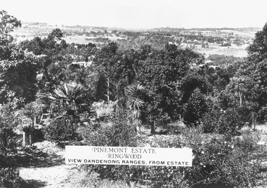
Photograph, Two images of view from Pinemont Estate, Loughnans Hill, looking east, c1930
Black and white photograph of view. Trees and bushes in foreground, orchards and mountains towards background. (2 copies)Typed on photograph, "Pinemont Estate, Ringwood. View Dandenong Ranges, from estate". Typed below photograph, "View from Loughnans Hill, looking east, c1930. Club Hotel can just be seen top right corner". -
 Ringwood and District Historical Society
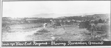
Photograph, Birds eye view East Ringwood - Showing Recreation Ground. Mt. Dandenong Rd. on right. Taken from present Civic Centre site. Football final in progress - 1923
Written below photograph, "Birds eye view East Ringwood - Showing Recreation Ground". Typed below photograph, "Mt. Dandenong Rd. on right. Taken from present Civic Centre site. Football final in progress - 1923". -
 Ringwood and District Historical Society
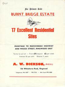
Flyer, Land Sale Brochure, Burnt Bridge Estate, Ringwood East/Croydon, Vic. - circa 1959
Bi-folded single sheet with black and red print both sides including subdivision features and local facilitiesSubdivision layout includes Marcus Road, Maggs Street and Maroondah Highway Croydon/Ringwood East. (Agent) A.W. Dickson, 136 Whitehorse Road, Ringwood, Telephones WU 6007, WU 7016, after hours WU 6868. -
 Eltham District Historical Society Inc
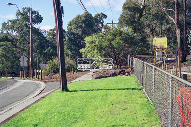
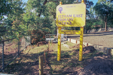
Photograph - Colour Print, Peter Pidgeon, Eltham East Primary School, Grove Street, Eltham, September 1999
These photos were taken to support an application regarding 'greening' in school landscapes. The school went on to win a voucher for education supplies from 'Windmill'. Eltham East Primary School was opened in August 1963.eltham east primary school, grove street -
 Eltham District Historical Society Inc
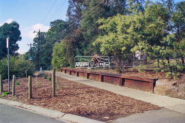
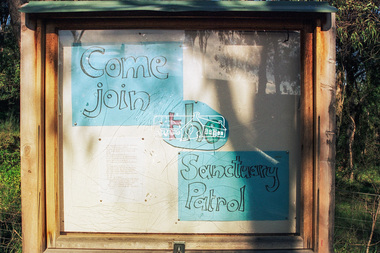
Photograph - Colour Print, Peter Pidgeon, Eltham East Primary School, Grove Street, Eltham, September 1999
These photos were taken to support an application regarding 'greening' in school landscapes. The school went on to win a voucher for education supplies from 'Windmill'. Eltham East Primary School was opened in August 1963.eltham east primary school, luck street, wildlife sanctuary -
 Eltham District Historical Society Inc
Folder, Thank You letters from Eltham East Primary School, May 2006
Handwritten letters by individual primary school students from Eltham East primary School sent to Eltham District Historical Society following an excursion to the Eltham Local History centre and heritage precinct.10 pages of handwritten letters in landscape format on lined paperHG Booklet 19harry gilham collection, eltham east primary school, education program, thank you, letters, school tours -
 Ringwood and District Historical Society
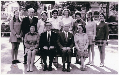
Photographs, School photographs associated with Nesta Potts and Alfred Potts, including Staff photograph circa 1969 Heathmont East Primary School - Alfred Potts in the front row wearing glasses, Nesta in front row right, with Head Teacher (Angus MacCallum?) between them. Of interest is the late Joan Kirner (former Premier of Victoria, d.2015) third from the right, back row
Letter dated 14-Jun-2015 from Victoria Potts to RDHS with four school photographs associated with her parents, Nesta Potts and Alfred Potts.; a) Staff photograph circa 1969 Heathmont East Primary School, including Alfred Potts in the front row wearing glasses, Nesta in front row right, with Head Teacher (Angus MacCallum?) between them. Of interest is the late Joan Kirner (former Premier of Victoria, d.2015) third from the right, back row.; b) Heathmont East State School Grade 1A 1968; c) Eastwood State School Grade 4B 1968; d) Heathmont State School Grade 2 1956 +Additional Keywords: Potts, Victoria / Potts, Alfred / Potts, Nesta / Kirner, Joan -
 Federation University Historical Collection
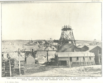
Book, J.W. Gregory, Memoirs of the Geological Survey of Victoria No. 4: The Ballarat East Gold-Field, 1907, 1907
Blue soft covered report with 40 plates and plans. Inciudes Geology of Ballarat. Little Bendigo Goldfield, Ballarat West Goldfield, Ballarat East Goldfield, history, nuggets, indicators, faults, microscopic structure of Ballarat Rocks and ores, general type of the Ballarat East Mines and the genesis of their ores. Mines include New Zealand Trust, Llanberris No. 1, Llanberris No 2, Victoria United, Britannia United, New Britannia, Last Chance, Exchange, Normanby North, New Normanby, North Woah Hawp. Photpgraphic plates include: Victoria United Mine, Llanberres No. 1, Normanby North, North Woah Hawp Mine, View looking south from the Britannia Mullock Heap, View from Sovereign Hill, The place in Learmonth Street Golden Point where gold was first discovered at Ballarat. j.w. gregory, ballarat east, ballarat east goldfield, e.j. dunn, geolological survey of victoria, new zealand trust, llanberris no. 1, llanberris no 2, victoria united, britannia united, new britannia, last chance, exchange, normanby north, new normanby, north woah hawp, mining, indicators, gold mining, poppet head -
 Kew Historical Society Inc
Plan - Subdivision Plan, Erin Heights Estate, East kew, 1917
Pru Sanderson, in her groundbreaking ‘City of Kew Urban Conservation Study : Volume 2 - Development History’ (1988), summarised the periods of urban development and subdivisions of land in Kew. The periods that she identified included 1845-1880, 1880-1893, 1893-1921, 1921-1933, 1933-1943, and Post-War Development. These periods were selected as they represented periods of rapid growth or decline in urban development. An obvious starting point for Sanderson’s groupings involved population growth and the associated economic cycles. These cycles also highlighted urban expansion onto land that was predominantly rural, although in other cases it represented the decline and breakup of large estates. A number of the plans in the Kew Historical Society’s collection can also be found in other collections, such as those of the State Library of Victoria and the Boroondara Library Service. A number are however unique to the collection.The Kew Historical Society collection includes almost 100 subdivision plans pertaining to suburbs of the City of Melbourne. Most of these are of Kew, Kew East or Studley Park, although a smaller number are plans of Camberwell, Deepdene, Balwyn and Hawthorn. It is believed that the majority of the plans were gifted to the Society by persons connected with the real estate firm - J. R. Mathers and McMillan, 136 Cotham Road, Kew. The Plans in the collection are rarely in pristine form, being working plans on which the agent would write notes and record lots sold and the prices of these. The subdivision plans are historically significant examples of the growth of urban Melbourne from the beginning of the 20th Century up until the 1980s. A number of the plans are double-sided and often include a photograph on the reverse. A number of the latter are by noted photographers such as J.E. Barnes.The Erin Heights Estate in Kew included just seven lots in in Valerie Street. These were all that remained of this wartime subdivision, the other 11 allotments on Balfour and Belford Roads having already been sold. Balfour Road was to be only a temporary name as the street is currently called Windella Avenue. Now, the parkland opposite the subdivision is the reserve created from the route of the Outer Circle Railway. This Railway reached Kew East in 1925, but had been planned as far back as 1873. The development focuses on the benefits of living in Kew: being at the highest of Kew’s ‘suburbs’; being a good residential area; its rapid growth; and the proximity of the Kew East tram in High Street. In 1917, the electric tramline only extended to a terminus at the Harp of Erin hotel. The terminus is clearly represented on the plan.subdivision plans - east kew, erin heights estate -
 Melbourne Tram Museum
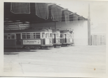
Photograph - Black & White Photograph/s, Chris Phillips, Feb. 1969
Black and white photograph, of the front of the "new" shed at Malvern tram depot, 9/2/1969, with tram SW6 898, and W2's (594, 572) and W5 775 at the front of the roads. Taken by Chris Phillips and printed on Kodak Paper. Tram 839 has a side panel advertisement for "Permasette Wave Set Lotion"On the rear in red ink "Malvern Depot 9/2/69"trams, tramways, mmtb, malvern depot, tram 898, tram 594, tram 572, tram 775 -
 Latrobe Regional Gallery
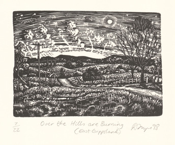
Print, FRAZER, David b. 1966 Foster, Victoria, Over the hills are burning (East Gippsland), 1998
Wood engravingSigned and dated 'D Frazer 98' lower right corner under printed image. Titled 'Over the Hills are Burning (East Gippsland)' centred below print. Edition 7/22, lower left corner under printed image. -
 Kew Historical Society Inc
Plan - Subdivision Plan, J R Mathers & McMillan, Myrtle Hill Estate, East Kew, circa 1949, c.1949
The Kew Historical Society's map collection includes a substantial number of real estate subdivision plans, mainly of Kew but also of surrounding suburbs in Melbourne. Most of the subdivision plans date from the 1920s and 1930s when the districts old homes and local farmland were being split up to accommodate residential growth in the postwar period. These early plans were assembled by a local firm, Jas R Mather & McMillan, which had an office in Cotham Road. Many of the plans, and sometimes photos, were annotated by the agents.Subdivision plans are historically important documents used as evidence for the growth of suburbs in Australia. They frequently provide information about when the land was sold as well as evidence relating to surveyors and real estate and financial agents. The numerous subdivision plans in the Kew Historical Society's collection represent working documents, ranging from the initial sketches made in planning a subdivision to printed plans on which auctioneers or agents listed the prices for which individual lots were sold. In a number of cases, the reverse of a subdivision plan in the collection includes a photograph of a house that was also for sale by the agent. These photographs provide significant heritage information relating house design and decoration, fencing and household gardens.The photograph may also be aesthetically significant depending on the importance of the photographic atelier.Myrtle Hill, at 14 Vista Avenue, Kew, is of local historical and architectural significance as a good example of a large and imposing single-storey Italianate house of the early 1870s surviving in Kew. Originally sited on a large allotment overlooking Normanby Road, the setting of the house has been dramatically altered through extensive subdivision and development. The subdivision plan of the ‘Myrtle Hill Estate’ indicates that in one such subdivision, 11 allotments were created fronting Bowyer Avenue, Myrtle Avenue, and Normanby Road. The outline and building profile of Myrtle Hill is shown on the west side of Bowyer Avenue.The full (typed) title of this subdivision plan is :"Plan of SUBDIVISION of part of CROWN PORTION 83. / at KEW / PARISH OF BOROONDARA. / COUNTY OF BOURKE". / "MYRTLE HILL ESTATE / EAST KEW" In addition to the Title and subtitle, the plan also lists the advantages of the subdivision. -
 Whitehorse Historical Society Inc.
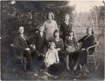
Photograph, Lowen Family, C1931
The Lowen family were one of the first to settle in East Burwood. They were orchardists.Black and white photograph of the Lowen family of East Burwood taken outside near their orchard in about 1931. Both parents are seated on cane chairs. Standing: (left to right) Cedric Jnr.,Thelma, Florence. Seated: Cedric Lowen, Merle, Joy and Lucy Lowen (nee Tainton) In front: Shirleyorchardists, lowen, shirley, lowen family, cedric, thelma, florence, merle, lowen lucy (nee tainton), joy -
 Ringwood and District Historical Society
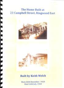
Book, Biography of owner of 23, Campbell Street, Ringwood East, 1920-1968
Keith Welch was a local builderBiography in yellow covered spiral binder containing a short biography of Keith Welch (26-12-1920 - 16-7-1968) who built and lived in the house at 23, Campbell Street, Ringwood East. Complied by his widow Gloria Welch in 2008. Contains many family photos and associated family events. The house was sold by Richard Carter in 2013. -
 Kew Historical Society Inc
Plan - Subdivision Plan, Forres Estate, East Kew, 1919, 1919
Pru Sanderson, in her groundbreaking ‘City of Kew Urban Conservation Study : Volume 2 - Development History’ (1988), summarised the periods of urban development and subdivisions of land in Kew. The periods that she identified included 1845-1880, 1880-1893, 1893-1921, 1921-1933, 1933-1943, and Post-War Development. These periods were selected as they represented periods of rapid growth or decline in urban development. An obvious starting point for Sanderson’s groupings involved population growth and the associated economic cycles. These cycles also highlighted urban expansion onto land that was predominantly rural, although in other cases it represented the decline and breakup of large estates. A number of the plans in the Kew Historical Society’s collection can also be found in other collections, such as those of the State Library of Victoria and the Boroondara Library Service. A number are however unique to the collection.Subdivision plans are historically important documents used as evidence of the growth of suburbs in Australia. They frequently provide information about when the land was sold on which a built structure was subsequently constructed as well as evidence relating to surveyors and real estate and financial agents. The numerous subdivision plans in the Kew Historical Society's collection represent working documents, ranging from the initial sketches made in planning a subdivision to printed plans on which auctioneers or agents listed the prices for which individual lots were sold. In a number of cases, the reverse of a subdivision plan in the collection includes a photograph of a house that was also for sale by the agent. These photographs provide significant heritage information relating house design and decoration, fencing and household gardens.An annotated subdivision plan for the Forres Estate, Kew East. The estate was advertised in 1919, the Melbourne Auctioneers being represented locally by Henry Kellett, Estate Agent of High Street, Kew. The name of the estate was derived from the mansion (demolished 2016) of the same name in Normanby Road, which was at one stage owned by the Mayor of Kew, Cr. J. S. Were.subdivision plans - kew, forres estate, argyle road, simpson street, hubert street, normanby road -
 Melbourne Tram Museum
Document - Notice, Melbourne & Metropolitan Tramways Board (MMTB), "Notice to Traffic Staff - East Burwood Tram Route Extension", 13/07/1978 12:00:00 AM
Duplicated foolscap notice - titled "Notice to Traffic Staff - East Burwood Tram Route Extension", printed by the MMTB, dated 13/7/1978 - signed by R. C. Drummond as Traffic Manager, No. C 2768 - advising of the opening of the extension on 20/7/1978, tram stops, running times, traffic signal lights, toilet facilities and track telephones.trams, tramways, mmtb, east burwood, opening, new tramway -
 Orbost & District Historical Society
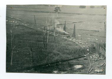
black and white photograph, 1916
This photograph shows the pile drivers at work in the construction of the viaduct across the Snowy River flats. The Snowy River Floodplain Railway Bridges, two sequential and exceptionally long and low timber railway bridges on the Snowy River floodplain just west of Orbost, were built in 1916, and provided the original terminus point for the Bairnsdale-Orbost railway. The bridges are 770 metres and 183 metres long respectively. The shorter bridge is of uniformly 4.57 metre timber-beam construction, and has a sweeping curve in its deck. The longer bridge has a combination of 4.57 metre and 6.1 metrespans, and two 3.66 metre spans. The bridges are constructed from 'Southern Mahogany', Eucalyptus Botryoides, which grew along the coast east of Bairnsdale. The Snowy floodplain bridges were initially built in the context of an early twentieth-century interest in American-style 'Developmental Railways', designed to open remote areas to closer settlement, even if that meant running at a loss. The line was closed in August 1987. (information from Victorian Heritage Database)This item is associated with the history of the Orbost-Bairnsdale railway line and therefore reflects the role that the rail line played in the social and economic history of Orbost.A black / white photograph of the farming flats at Orbost during the construction of the East Gippsland railway.orbost-railway east-gippsland-railway viaduct-orbost transport railway -
 Lakes Entrance Regional Historical Society (operating as Lakes Entrance History Centre & Museum)
Album, M Fish
Many copied from publications of Bairnsdale, Metung, Lakes Entrance, Lake TyersRed folder containing images of East Gippsland settlements and activities East Gippsland Victoriawaterways, township, ships and shipping -
Ringwood and District Historical Society
Magazine - Magazine/Periodical, Ringwood Inspectorate, Nature Notes, from East Ringwood Primary Schools Mothers Club. 1968, 1968
In the 1970s, Nature Notes was a publication managed by the Mothers Club at East Ringwood Primary School which raised funds for the school. It was printed, collated and delivered to the other primary schools in the area. Local expert Fred Rogers contributed.4 double paged magazines - typed with pen & ink drawings. +Additional Keywords: Rogers, F. -
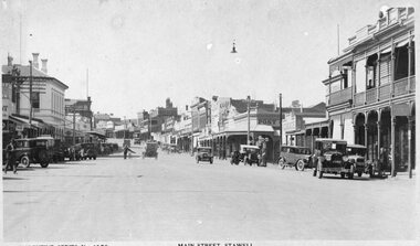 Stawell Historical Society Inc
Photograph, Main Street Stawell looking East from area in front of Town Hall -- Postcard c1930
Valentine Series No 1078 Main Street looking East from area in front of Town Hall c1930 Town Hall Hotel Post Office and Post Office Hotel and Bull and Mouth Hotel are visible. Vehicles in street.Valentine Series No. 1078 Main Street Stawellstawell business streetscape -
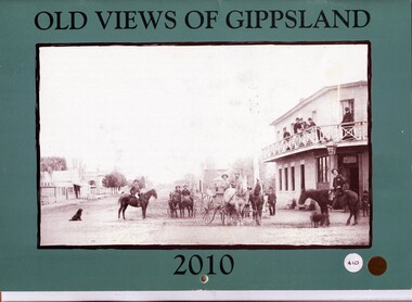 Orbost & District Historical Society
calendar, Old Views of Gippsland 2010, 2009
This calendar is one of a series published annually by East Gippsland Historical Society. It cost $10.This item is a useful reference tool.A 2010 stapled calendar, titled "Old Views of Gippsland". On the turquoise coloured front is a black/white photograph of the main street of Rosedale before the time of motor vehicles. It contains early photographs of East Gippsland, one for each month. There is a hole for hanging. The title is at the top and the year at the bottom in black print. -
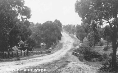 Ringwood and District Historical Society
Photograph, Maroondah Highway East, Ringwood- 1870. Sandy Creek, now Ringwood Lake
3 photographs (2 large black and white, 2 small- 1 black and white, 1 sepia) Written on all photographs, "View at Ringwood" Typed below large photograph: "Main St looking east. Right hand side of gully now Ringwood Lake. Written on back of sepia print: "1870, Sandy Creek now Ringwood Lake"