Showing 1519 items
matching farming.
-
 Wodonga & District Historical Society Inc
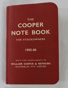
Booklet - Hamilton-Smith Collection "The Cooper Note Book for Stockowners" 1965 - 66
The Hamilton-Smith collection was donated by the children of Grace Mary Hamilton-Smith nee Ellwood (1911-2004) and John Hamilton-Smith (1909-1984) who settled in Wodonga in the 1940s. The Ellwood family had lived in north-east Victoria since the late 1800s. Grace’s mother, Rosina Ellwood nee Smale, was the first teacher at Baranduda in 1888, and a foundation member of the C.W.A. Rosina and her husband Mark retired to Wodonga in 1934. Grace and John married at St. David’s Church, Albury in 1941. John was a grazier, and actively involved in Agricultural Societies. The collection contains significant items which reflect the local history of Wodonga, including handmade needlework, books, photographs, a wedding dress, maps, and material relating to the world wars. This item has well documented provenance and a known owner. It forms part of a significant and representative historical collection which reflects the local history of Wodonga. It contributes to our understanding of social and family life in early twentieth century Wodonga, as well as providing interpretative capacity for themes including local history and social history. Small red booklet with white text embossing. wodonga, hamilton-smith, hamilton-smith collection, stock, cows, cow, agriculture, farm, farming, book -
 Wodonga & District Historical Society Inc
Functional object - Milk Can c. 1900s
North east Victoria was a major dairy producing region in the late nineteenth century. The first iteration of the Wodonga Butter Factory Ltd was established in 1892. Dairy was sent from farmers across the district for processing at the factory in Wodonga in the 1890s. Victorian creameries regularly exported frozen butter to London, stock was transported by rail for sale in Melbourne, and of course sold and consumed locally. E.W. Manns, of the prominent local Wodonga family, was a shareholder and was closely involved in the establishment of the Wodonga Butter Company. Many families living on farms also owned their own cow, and had equipment to process their own dairy products at home. Milk cans such as this one were used to store and transport milk from farms to dairies and butter factories for processing.This item represents the history of local industry in Wodonga and north east Victoria. A large metal milk can with handlesmilk, butter, cream, dairy, milk can, farming, farm, cow, rural, agriculture, wodonga -
 Wodonga & District Historical Society Inc
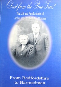
Book - Dust From the Pine Trees : The Life and Family Stories of Arthur and Elizabeth Ann Henman - From Bedfordshire to Barmedman, Lila McCann & Betty Lawrence
The story of the life, family and achievements of Arthur Henman, born in 1861 in Lidlington, Bedfordshire, England and his wife Elizabeth Ann nee Pollard of Bonegilla, Victoria. For a time on arrival in Australia at the age of 17, Arthur had a contract to supply timber to the New South Wales Railway Department. After marrying in 1888, Arthur and Elizabeth became successful dairy farmers in Glen Innes, northern New South Wales, before deciding to come to the Barmedman district. They took up the property, now well known as "Pine Valley." They had a pioneer's task to face for a thick belt of green timber stretched from the back door of their first home to Temora. Undaunted by the task, but with great determination and courage, they fashioned a first class property out of the wild and waste of those days and made valuable contribution to the fledgling communities until retirement from active farming in 1923 when they moved to Sydney.non-fictionThe story of the life, family and achievements of Arthur Henman, born in 1861 in Lidlington, Bedfordshire, England and his wife Elizabeth Ann nee Pollard of Bonegilla, Victoria. For a time on arrival in Australia at the age of 17, Arthur had a contract to supply timber to the New South Wales Railway Department. After marrying in 1888, Arthur and Elizabeth became successful dairy farmers in Glen Innes, northern New South Wales, before deciding to come to the Barmedman district. They took up the property, now well known as "Pine Valley." They had a pioneer's task to face for a thick belt of green timber stretched from the back door of their first home to Temora. Undaunted by the task, but with great determination and courage, they fashioned a first class property out of the wild and waste of those days and made valuable contribution to the fledgling communities until retirement from active farming in 1923 when they moved to Sydney.pioneers australia, pioneers nsw, arthur henman, elizabeth ann pollard, barmedman district nsw -
 Victorian Farmers Federation
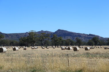
Photograph, Lisa Gervasoni, Hay bales in the Grampians Region, 27/01/2017
Hay bales are a key food in a grazing livestock production system. The paddock shows the co-existence of native vegetation which provides cover for livestock. Digital photographfarming, hay, native vegetation, agriculture, farm, western victoria -
 Victorian Farmers Federation
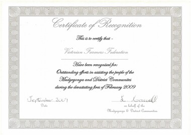
Work on paper - Certificate of recognition, Outstanding efforts in assisting the people of Mudgegonga and District Communities during devastating fires of February 2009
Relates to the Black Saturday bushfires in Victoria in February 2009A4 certifcate on paperbushfire, recovery, agriculture, farming, rural community -
 City of Kingston
Photograph - Colour, 29 January 1993
Bonbeach, Carrum and Patterson Lakes are suburbs in the City of Kingston. Bonbeach and Carrum were holiday destinations in early 20th century and over time the housing has converted to permanent residential structures. In Patterson Lakes, the area consists predominantly of newer housing developments and the tidal canal system which is accessible to many dwellings joins Port Phillip Bay.Bonbeach, Carrum and Patterson Lakes were previously part of the extensive Carrum Carrum Swamp. The area was once a source of fish and eels for the Mayone-Bulluk clan of the Bunurong people. Over time the area was drained and this allowed farming at Carrum and Bonbeach, although the area was prone to flooding. In the early 1920s and 30s the land was converted to residential dwellings. In 1973 investigations commenced nearby to Bonbeach and Carrum into the development of a unique residential area comprising canals and waterways. It was originally proposed to be known as "Gladesville". Circa 1974, the area was rezoned from rural to residential and named Patterson Lakes. Development has been continuous since the 1970s with staged construction of the waterways, residential housing, and supporting infrastructure and facilities.Laminated colour aerial photograph of the Bonbeach, Carrum and Patterson Lakes region within City of Kingston. This 1993 image includes Bonbeach High School prior to demolition, Bonbeach Primary School and Patterson River Golf Club. Sections of Patterson Lakes are not yet developed, including Rhode and Staten Islands. Long Island Point appears to be a recent development with many spare blocks and new houses under construction. The Patterson River marina is prominent and the river mouth as it meets Port Phillip Bay. The Carrum railway station is visible.Black type on white adhesive sticker: No. 6661 Black type on white adhesive sticker: 26E/6661, 29/1/93, 4.25 pm Black type on white adhesive sticker 29-1-93 Yellow circular adhesive stickerbonbeach, carrum, patterson lakes, patterson river, carrum carrum swamp, canals and waterways -
City of Kingston
Photograph - Colour, Circa 1993
Edithvale is a suburb in the City of Kingston. It is located between Aspendale and Chelsea on the Port Phillip Bay and built within remnant areas of the Carrum Carrum swamp. The foreshore precinct comprises a wide sandy beach, with low sand dunes and numerous historic boat sheds. The suburb consists of older style dwellings and former holiday houses, combined with mid-century housing and newer homes. The large blocks are increasingly subdivided and the existing dwellings demolished to accommodate units and townhouses, thus changing the landscape of the area and reducing the tree canopy.The beachside suburb of Edithvale was previously part of the extensive Carrum Carrum Swamp. The area was once a source of fish and eels for the Mayone-Bulluk clan of the Bunurong people. Over time the area was drained and predominantly devoted to dairy farming and holiday houses. The farms were gradually sold and subdivided with a large number of homes built after World War II and in the 1960s. Edithvale is mainly residential with a shopping strip along Nepean Highway but little significant industry was ever established in the area apart from a plaster works and confectionary factory, both now closed.Aerial colour photograph of Edithvale as viewed from Alexandra Avenue in the north to Ella Grove Chelsea/Edithvale in the south. The area is built-up with residential housing and facilities including Edithvale Primary School, numerous churches and the Edithvale Railway station. Large sections depict the remnant Carrum Carrum swamp. Edithvale Common and the former "Duck Inn" (Melbourne Water/Friends of Edithvale Seaford Wetlands) can be seen. Edithvale Recreational reserve, the valodrome and Edithvale Public Golf Course are prominent. The image shows vacant land in the area now known as Aspendale Gardens and the newer residential section of Chelsea Heights is not developed. A bike path has been established to cover the secondary drain. The Golf Links Court residential development located off Hughes Avenue is a large vacant block.Yellow circular adhesive sticker on plastic Black ink (marker): * (asterisk) Black type on white adhesive sticker: P000108edithvale, aspendale, chelsea, carrum carrum swamp -
City of Kingston
Photograph - Colour, 6 March 1993
Edithvale is a suburb in the City of Kingston. It is located between Aspendale and Chelsea on the Port Phillip Bay and built within remnant areas of the Carrum Carrum swamp. The foreshore precinct comprises a wide sandy beach, with low sand dunes and numerous historic boat sheds. The suburb consists of older style dwellings and former holiday houses, combined with mid-century housing and newer homes. The large blocks are increasingly subdivided and the existing dwellings demolished to accommodate units and townhouses, thus changing the landscape of the area and reducing the tree canopy.The beachside suburb of Edithvale was previously part of the extensive Carrum Carrum Swamp. The area was once a source of fish and eels for the Mayone-Bulluk clan of the Bunurong people. Over time the area was drained and predominantly devoted to dairy farming and holiday houses. The farms were gradually sold and subdivided with a large number of homes built after World War II and in the 1960s. Edithvale is mainly residential with a shopping strip along Nepean Highway but little significant industry was ever established in the area apart from a plaster works and confectionary factory, both now closed.Laminated aerial colour photograph of Edithvale as viewed from Alexandra Avenue in the north to Ella Grove Chelsea/Edithvale in the south. regents Park Aspendale can be seen in the top left. The area is built-up with residential housing and facilities including Edithvale Primary School, numerous churches and the Edithvale Railway station. Large sections depict the remnant Carrum Carrum swamp. Edithvale Common and the former "Duck Inn" (Melbourne Water/Friends of Edithvale Seaford Wetlands) can be seen. Edithvale Recreational reserve, the valodrome and Edithvale Public Golf Course are prominent. The image shows vacant land in the area now known as Aspendale Gardens and the newer residential section of Chelsea Heights is not developed. A bike path has been established to cover the secondary drain. The Golf Links Court residential development located off Hughes Avenue is a large vacant block.Black type on white adhesive label: 6-3-93 Black type on white adhesive label: 25/9211, 6/3/93, 11.20 am Black type on white adhesive label: 9211 Yellow circular adhesive sticker Black pencil: 9211 6-3-93 arrow pointing Nedthvale, carrum carrum swamp, aspendale, chelsea -
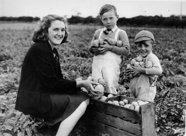 City of Kingston
Photograph - Black and white, c.1945
This photograph shows Gladys Marriott, aged 15, in the potato fields of her father's property in Moorabbin. Her cousin Graeme (centre) and younger brother Alfred (right) are with her. Moorabbin is a suburb in the City of Kingston that was originally established as a rural market gardening communityThe Marriott property in Moorabbin was adjacent to a secret wartime wireless receiving station established in March 1942 in Chesterville Road, Moorabbin. The station was established on requisitioned market garden properties, and soon housed WRAN (Women's Royal Australian Navy) personnel and up to 35 US Navy servicemen. The Navy personnel intercepted Japanese coded communications and then despatched these by motorbike messenger to Queens Road, St Kilda where the Directorate of Naval Communications and the code-breaking unit called FRUMEL (Fleet Radio Unit - Melbourne) were housed. The information intercepted by the wireless receiving station helped shape the Allied response to Japan's advances in the Pacific. Declassified defence records show that this unprepossessing station handled some of World War II's most sensitive secrets, however the local community were unaware of its significance. Gladys Marriott, working on her father's property, would regularly take the family's cows to graze in the fields adjoining the station with no concept of what the Navy personnel were doing. Black and white photograph of a young woman and two small boys standing around a wooden crate filled with potatoes. They each have potatoes in their hands. They are standing in a field. Handwritten in red ink: A 601 / 72% Handwritten in black ink: CHAP 6. Handwritten in black ink: GLADYS STOTT (MARIOTT) / DURING WAR YEARS / With Spybase Storymarket garden, children, farming, local production, world war ii, wireless receiving station, moorabbin -
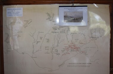 Buninyong Visitor Information Centre
Map, et al, Early Squatters Stations 1837-1838, This map was created in 2016 by a group of U3A Ballarat students under the Tutor, John Olsen
The map shows rivers and pastoral holdings from 1837 to 1838. Stations occupied around Geelong in 1837 are shown in red and those occupied in 1838 are shown in black. Reproduction of a coloured map shows pastoral stations around the Geelong area from 1837-1940. pastoralism, stations, farming, settlement, squatters -
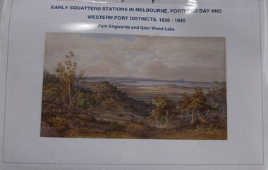 Buninyong Visitor Information Centre
Booklet - Index to Map, et al, Early Squatters' Stations in Melbourne, Portland Bay and Western Port Districts, 1836-1840, 2016
Photocopied copy of an index.Horizontally bound A4 typed listing with coloured illustration on the front page and a clear plastic cover sheet.non-fictionPhotocopied copy of an index.settlers, farming, pastoralism -
 Wooragee Landcare Group
Photograph, 3rd April 2004
This photograph depicts fox behaviour specialist Camille Veselsky demonstrating the use of a fox bait trap at an event conducted as part of an awareness campaign highlighting damage done to farm and domestic animals and native wildlife in April 2004. Camille Veselsky is a specialist in fox behaviour who worked for the Hume Rural lands Protection Board on pest animal control for 27 years. This date is suggested by the photograph's position in the 2004-2005 Wooragee Landcare Group Coordinator's Report folder. A note accompanying the item suggests an alternative date of 24th June 2004, however. This event raised awareness about the impacts of foxes in rural areas and provided practical training in techniques to control their populations. Flyers contained in the parent folder suggest that baiting may have been agreed as a method of fox control as the event depicted was followed by a two week baiting campaign a fortnight later. Pictured in this photograph, left to right: unknown, unknown, Quentin Mansfield, Graeme Missen, unknown, Helmut Wiemann, presenter Camille Veselsky, Ursula Wiemann, unknowns. A note accompanying the items suggests the photograph may have been taken by Karen Bowley or Maree Missen. In the folder, the photograph is accompanied by a printed label stating: 'Sensible precautions must be taken when handling FOXOFF.' Regional areas like Wooragee are susceptible to fox attacks due to the availability of food such as rubbish, scraps, native wildlife and livestock. Foxes can have a huge impact on native wildlife and domestic life as they are known to chew through irrigation systems, dig-up and defecate in gardens, raid rubbish bins and harass other domestic animals. Ground-dwelling native species are particularly susceptible to predation by foxes, which when combined with loss of habitat can endanger these species. Affected species include Speckled Warblers, Plovers, Diamond Firetails, Spotted Quail-Thrushes, Turquoise Parrots, Dunnarts, Bandicoots, Phascogales, skinks, geckos and legless lizards. This photograph is significant as an example of awareness raising and threat control programs undertaken by Wooragee Landcare Group in the 2000s in Indigo Shire. Landscape coloured photograph printed on gloss paper. Reverse: WAN NA 0ANA2N0 NNN+ 3 8743 / [PRINTED] 24 / [HANDWRITTEN] (No. 1 1) / 257 [PRINTED}wooragee landcare, wooragee, north-east victoria, indigo shire, landcare movement, 2004, fox control, pest control, native animal protection, farming, farm life, foxes, vermin, baiting, traps, speckled warbler, plovers, diamond firetails, spotted quail-thrush, turquoise parrot, dunnarts, bandicoots, phascogales, skinks, geckos, legless lizard, chickens, ducks, guinea-pigs, camille veselsky, quentin mansfield, graeme missen, helmut wiemann, ursula wiemann, karen bowley, maree missen -
 Wooragee Landcare Group
Photograph, 3rd April 2004
This photograph depicts fox behaviour specialist Camille Veselsky demonstrating the use of a fox bait trap at an event conducted as part of an awareness campaign highlighting damage done to farm and domestic animals and native wildlife in April 2004. Camille Veselsky is a specialist in fox behaviour who worked for the Hume Rural lands Protection Board on pest animal control for 27 years. This date is suggested by the photograph's position in the 2004-2005 Wooragee Landcare Group Coordinator's Report folder. A note accompanying the item suggests an alternative date of February 2004, however. This event raised awareness about the impacts of foxes in rural areas and provided practical training in techniques to control their populations. Flyers contained in the parent folder suggest that baiting may have been agreed as a method of fox control as the event depicted was followed by a two week baiting campaign a fortnight later. Pictured in the photograph, left to right: unknown, Quentin Mansfield; four unknown people; Mary Prowse; two unknown people; Helmut Wiemann; unknown person. In the folder, the photograph is accompanied by a printed label stating: 'Train foxes to take free feeds before using the 1080. Small traces of fish oil can help attract foxes to the bait station.' Regional areas like Wooragee are susceptible to fox attacks due to the availability of food such as rubbish, scraps, native wildlife and livestock. Foxes can have a huge impact on native wildlife and domestic life as they are known to chew through irrigation systems, dig-up and defecate in gardens, raid rubbish bins and harass other domestic animals. Ground-dwelling native species are particularly susceptible to predation by foxes, which when combined with loss of habitat can endanger these species. Affected species include Speckled Warblers, Plovers, Diamond Firetails, Spotted Quail-Thrushes, Turquoise Parrots, Dunnarts, Bandicoots, Phascogales, skinks, geckos and legless lizards. This photograph is significant as an example of awareness raising and threat control programs undertaken by Wooragee Landcare Group in the 2000s in Indigo Shire.Landscape coloured photograph printed on gloss paper. Reverse: 25 / 2 [HANDWRITTEN] WAN NA 0ANA2N0 NNN+ 1 8743 / [PRINTED] (No.12) / 258wooragee, wooragee landcare group, indigo shire, north-east victoria, fox, foxes, pest control, vermin, conservation, baiting, trapping, farming, wildlife, speckled warblers, plovers, diamond firetails, spotted quail-thrush, turquoise parrot, dunnarts, bandicoots, phascogales, skinks, geckos, legless lizards, camille veselsky -
 Wooragee Landcare Group
Photograph, 3rd April 2004
This photograph depicts people attending the 'Spotlight on Fox' event watching a demonstration. The event was conducted as part of an awareness campaign highlighting damage done to farm and domestic animals and native wildlife in April 2004. This date is suggested by the photograph's position in the 2004-2005 Wooragee Landcare Group Coordinator's Report folder. A note accompanying the item suggests an alternative date of February 2004, however. This event raised awareness about the impacts of foxes in rural areas and provided practical training in techniques to control their populations. Flyers contained in the parent folder suggest that baiting may have been agreed as a method of fox control as the event depicted was followed by a two week baiting campaign a fortnight later. Pictured in this photograph, left to right: unknown; Sue Berwick ; Jerry Alexander; rest unidentified. A note accompanying the items suggests the photograph may have been taken by Karen Bowley or Maree Missen. Regional areas like Wooragee are susceptible to fox attacks due to the availability of food such as rubbish, scraps, native wildlife and livestock. Foxes can have a huge impact on native wildlife and domestic life as they are known to chew through irrigation systems, dig-up and defecate in gardens, raid rubbish bins and harass other domestic animals. Ground-dwelling native species are particularly susceptible to predation by foxes, which when combined with loss of habitat can endanger these species. Affected species include Speckled Warblers, Plovers, Diamond Firetails, Spotted Quail-Thrushes, Turquoise Parrots, Dunnarts, Bandicoots, Phascogales, skinks, geckos and legless lizards. This photograph is significant as an example of awareness raising and threat control programs undertaken by Wooragee Landcare Group in the 2000s in Indigo Shire.Landscape coloured photograph printed on gloss paperReverse: WAN NA 0ANA2N0 NNN 0 8743 / [PRINTED] (No. 13) / 259wooragee, wooragee landcare, indigo shire, north-east victoria, foxes, fox, pest control, vermin, conservation, baiting, trapping, events, 2004, wildlife, speckled warbler, plovers, diamond firetails, spotted quail-thrush, turquoise parrots, dunnarts, bandicoots, phascogales, skinks, geckos, legless lizards, farming, chickens, ducks, guinea-pigs -
 Wooragee Landcare Group
Photograph, 28th April 2004
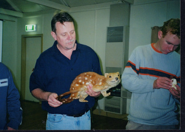
Wooragee Landcare was formed in 1989 to promote sustainable conservation and land-use practices in the North-East region of Victoria. The organisation's work has included public awareness and education campaigns to control invasive, introduced species and protect native wildlife, such as campaigns to bait or trap foxes and to identify and monitor quoll populations in the region. The organisation has drawn on the work of a variety of Government and academic experts to inform best practice approaches are utilised. In 2004 Andrew Murray, a leading quoll expert from Parks Victoria, conducted training for Wooragee Landcare members and the local community in how to identify potential quoll habitat and populations (through identifying scat and other methods). Spotted-tail or Tiger quolls were known to have lived in the Mt Pilot and Stanley Plateau region previously but habitat encroachment, competitor species such as foxes and natural disasters had reduced sightings in recent years. The Spotted-Tail quoll (formerly known as the Tiger Quoll) is the largest of four species of native marsupial carnivore on mainland Australia, and the second-largest carnivore (after the dingo). The species' scientific name, Dasyurus maculatus, references its' 'hairy tail'. Adults are approximately 125cm long, including their long tail, and weigh around 5 kilograms. The Spotted-tail quoll is currently considered to be a threatened species, but other species are currently listed as endangered. This photograph is significant as an example of wildlife protection awareness programs undertaken by Wooragee Landcare Group in the 2000s in Indigo Shire.Landscape coloured photograph printed on gloss paper.Reverse: WAN NA 0ANA2N0 NNN+ 2 8743 / [PRINTED] (No.22) / 268wooragee, wooragee landcare, kiewa landcare, indigo shire, north-east victoria, farming, conservation, wildlife, quoll, quolls, marsupials, predators, simon feillafe, andy murray, south-east forests, spotted tail quoll, mt pilot, stanley plateau, andrew murray -
 Wooragee Landcare Group
Photograph, 28th April 2004
Wooragee Landcare was formed in 1989 to promote sustainable conservation and land-use practices in the North-East region of Victoria. The organisation's work has included public awareness and education campaigns to control invasive, introduced species and protect native wildlife, such as campaigns to bait or trap foxes and to identify and monitor quoll populations in the region. The organisation has drawn on the work of a variety of Government and academic experts to inform best practice approaches are utilised. In 2004 Andrew Murray, a leading quoll expert from Parks Victoria, conducted training for Wooragee Landcare members and the local community in how to identify potential quoll habitat and populations (through identifying scat and other methods). Spotted-tail or Tiger quolls were known to have lived in the Mt Pilot and Stanley Plateau region previously but habitat encroachment, competitor species such as foxes and natural disasters had reduced sightings in recent years. The Spotted-Tail quoll (formerly known as the Tiger Quoll) is the largest of four species of native marsupial carnivore on mainland Australia, and the second-largest carnivore (after the dingo). The species' scientific name, Dasyurus maculatus, references its' 'hairy tail'. Adults are approximately 125cm long, including their long tail, and weigh around 5 kilograms. The Spotted-tail quoll is currently considered to be a threatened species, but other species are currently listed as endangered.This photograph is significant as an example of wildlife protection awareness programs undertaken by Wooragee Landcare Group in the 2000s in Indigo Shire.Landscape coloured photograph printed on gloss paper.Reverse: WAN NA 0ANA2N0 NNN+ 1 8743 / [PRINTED] (No.23) / 269wooragee, wooragee landcare, indigo shire, north-east victoria, andrew murray, queries about quolls, wildlife, conservation, farming, predators, spotted tail quolls, quolls, marsupials, south-east forests, mt pilot, stanley plateau -
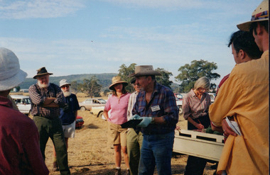
 Wooragee Landcare Group
Photograph, 5 September 2004
This photograph was taken at Samaria Farm on Sunday the 5th of September as part of a day trip by the Wooragee Landcare Group. The event was about looking at land use on small farms and as a social get-together for the Group. Wooragee Landcare was also researching how small landholders could run some enterprises around the time of this trip. Samaria Farm is located in northeast Victoria, near Mount Samaria, which is located 130 km northeast of Melbourne. Samaria Farm was owned by Sue and Due Matheson at the time of the trip and had a renowned rose garden, pigs, poultry, alpacas, and goats on their nine-hectare farm. The rose garden consists of 3000 damask roses. Samaria Farm distils the oil from these roses and is the only farm in Australia to do this. Rose oil has historically been used for religious and medical use. 20 kg of rose buds are picked by hand every day, which is then distilled and produced 5 to 8 ml of oil. The entire four-week season produces 80 to 100 ml of oil. Rose water is also created during this process and produces about 300 litres per season. Along with the oil, the Farm also harvests lemons, lime, olives, and oranges. The Farm is currently owned by Utako and Anthony since 2022, with Vicki and Allan Wight being the previous owners. Wooragee Landcare Group was created in 1988. Its core mission is to work towards eradicating animals and pests from the land to protect the natural vegetation and promote revegetation projects. This photograph is a great example of the type of events that Wooragee Landcare Group has organized, while educating the public about the importance of land use management. The group is important to the community and for the environment. Landscape colored photograph printed on gloss paperReverse: WAN NA E0NA2N2. ANN+ 1 4240/ [PRINTED] (No. 19) / 372samaria farm, wooragee landcare group, wooragee, victoria, mount samaria, farming, roses, rose oil, damask roses, agriculture, pests, vegetation -
 Marysville & District Historical Society
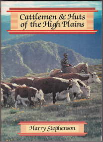
Book - Paperback book, Harry H. Stephenson, Cattlemen & Huts of the High Plains, 1980
A book that records the early development of Victoria's alpine regions by the pioneer cattlemen.Paperback book. The cover photograph shows snow plains, wildflowers, cattle, cattlemen and the mountain scenery across the Howqua Valley in Victoria.non-fictionA book that records the early development of Victoria's alpine regions by the pioneer cattlemen.cattle, victoria, beeding, history, hill farming, mountain life, cattlemen -
 Warrnambool and District Historical Society Inc.
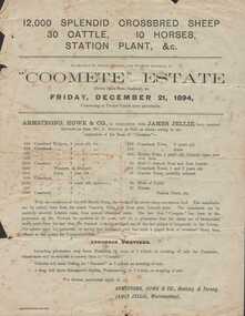
Document - Advertisement, Coomete estate, Sale of stock and plant, 1894
Augustus Bostock was the 9th child of Robert & Rachael Bostock of Vaucluse Epping Forest, Van Diemen’s Land. He was only 4 years old when his mother died. He was inspired by his father to seek his fortune in the Western District of Victoria. He arrived around 1850. He married Margaret Aitkin in July 1865. Augustus owned several properties in the district and leased others. He sat on the court of Warrnambool, Mortlake or Hexham as required. He resided at Marramook in Hawkesdale and later moved to Vaucluse in Hopetoun Road Warrnambool, where he died in 1920 at the age of 87. He was involved in many aspects of life in the Western District, racing, cricket, and social activities to name a few. This flyer is advertising the sale of 12000 sheep, 30 cattle, 10 horses and station plant at the expiration of the lease of Coomete. It states that Coomete has been in the possession of Mr. Augustus Bostock for over 30 yearsThis is one of a number of documents which relate to the Bostock family who were one of the most important pioneering families of the Western District. They owned and leased various properties around Warrnambool and were involved in many aspects of social and business life. This document contains a detailed view of the stock owned by Augustus Bostock at Coomete. From a social perspective the details provided show that it was an event of some importance in the farming area.Cream paper with heading and title in large font at the top with Coomete Estate in uppercase inside banner lines underneath with details of stock and numbers to be sold in smaller print below. Mercer printer Geelong. For further particulars apply to Armstrong, Howe & Co Geelong and Terang, James Jellie Warrnambool.coomete, warrnambool, augustus bostock, coomete lease, 1894